

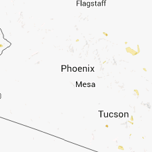
Hail Map for Monday, July 7, 2014

Number of Impacted Households on 7/7/2014
0
Impacted by 1" or Larger Hail
0
Impacted by 1.75" or Larger Hail
0
Impacted by 2.5" or Larger Hail
Square Miles of Populated Area Impacted on 7/7/2014
0
Impacted by 1" or Larger Hail
0
Impacted by 1.75" or Larger Hail
0
Impacted by 2.5" or Larger Hail


Cities Most Affected by Hail Storms of 7/7/2014
| Hail Size | Demographics of Zip Codes Affected | ||||||
|---|---|---|---|---|---|---|---|
| City | Count | Average | Largest | Pop Density | House Value | Income | Age |
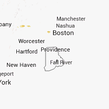
| Saint Louis, MO | 3 | 1.83 | 2.00 | 3143 | $109k | $47.0k | 41.7 |
| Cedar Hill, MO | 1 | 2.00 | 2.00 | 342 | $100k | $46.9k | 40.8 |
| Scottsbluff, NE | 1 | 1.75 | 1.75 | 157 | $75k | $31.0k | 37.9 |
| Burnsville, MN | 1 | 1.75 | 1.75 | 2473 | $153k | $58.3k | 35.9 |
| Central City, NE | 1 | 1.75 | 1.75 | 26 | $67k | $34.8k | 41.8 |
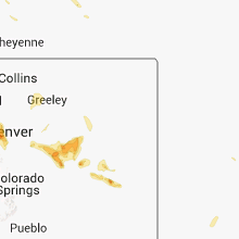
| Arvada, CO | 1 | 1.75 | 1.75 | 2323 | $204k | $69.9k | 43.0 |
| Bruning, NE | 1 | 1.75 | 1.75 | 4 | $46k | $33.6k | 47.1 |
| Gering, NE | 1 | 1.75 | 1.75 | 52 | $75k | $34.5k | 38.2 |
| Savage, MN | 1 | 1.75 | 1.75 | 1910 | $167k | $76.0k | 34.5 |
| Clatonia, NE | 1 | 1.75 | 1.75 | 9 | $49k | $38.8k | 46.8 |
| Bayard, NE | 1 | 1.75 | 1.75 | 5 | $52k | $30.8k | 43.5 |
| Sheldon, WI | 1 | 1.75 | 1.75 | 11 | $56k | $34.5k | 40.8 |
| Sutton, NE | 1 | 1.75 | 1.75 | 8 | $62k | $35.2k | 43.4 |
| Oconto, NE | 1 | 1.75 | 1.75 | 1 | $26k | $27.3k | 48.8 |
| Clay Center, KS | 1 | 1.75 | 1.75 | 17 | $56k | $35.2k | 44.5 |
Hail and Wind Damage Spotted on 7/7/2014
Filter by Report Type:Hail ReportsWind Reports
States Impacted
Kansas, Vermont, Wisconsin, Illinois, Massachusetts, Indiana, Arizona, New York, Pennsylvania, Minnesota, Nebraska, Kentucky, Ohio, Iowa, Connecticut, North Dakota, Missouri, South Carolina, Texas, Colorado, NevadaKansas
| Local Time | Report Details |
|---|---|
| 11:33 AM CDT | Power lines and trees down. city without powe in franklin county KS, 57.8 miles SW of Kansas City, MO |
| 11:38 AM CDT | Semi truck blown over on interstate 35 near williamsbur in franklin county KS, 56.4 miles N of Chanute, KS |
| 5:19 PM CDT | Storm damage reported in logan county KS, 21.2 miles SSE of Colby, KS |
| 5:20 PM CDT | Several 6 to 8 inch tree limbs down. some trees also down. a couple of canopies on buildings downtown were blown off. time estimated by rada in logan county KS, 21.2 miles SSE of Colby, KS |
| 8:27 PM CDT | Quarter sized hail reported near Clay Center, KS, 40.1 miles WNW of Manhattan, KS, estimated hail of 1 inch in size |
| 8:27 PM CDT | Golf Ball sized hail reported near Clay Center, KS, 28.9 miles WNW of Manhattan, KS, 1.75 inch hail estimated |
| 8:28 PM CDT | Quarter sized hail reported near Clay Center, KS, 32.2 miles WNW of Manhattan, KS |
| 9:17 PM CDT | 50-60 mph wind gusts felt by trained spotter. no major damage reporte in pottawatomie county KS, 9.7 miles NE of Manhattan, KS |
| 9:39 PM CDT | Quarter sized hail reported near Hanover, KS, 52.4 miles NNW of Manhattan, KS |
| 9:48 PM CDT | Storm damage reported in atchison county KS, 50.1 miles NW of Kansas City, MO |
| 9:51 PM CDT | Storm damage reported in nemaha county KS, 46.2 miles NNE of Manhattan, KS |
| 10:01 PM CDT | 70 mph winds and many small tree branches littering the road near the junction of kansas highways 16 and 1 in pottawatomie county KS, 17.5 miles N of Manhattan, KS |
| 10:14 PM CDT | Strong winds with medium branches dow in clay county KS, 33.5 miles WNW of Manhattan, KS |
| 10:14 PM CDT | Quarter sized hail reported near Clay Center, KS, 33.5 miles WNW of Manhattan, KS |
| 10:20 PM CDT | Power lines dow in pottawatomie county KS, 14.4 miles ENE of Manhattan, KS |
| 10:20 PM CDT | Power lines dow in pottawatomie county KS, 26.4 miles E of Manhattan, KS |
| 10:20 PM CDT | Power lines dow in pottawatomie county KS, 13.6 miles E of Manhattan, KS |
| 10:21 PM CDT | Storm damage reported in riley county KS, 6 miles WSW of Manhattan, KS |
| 10:22 PM CDT | 60 mph wind gust estimate in pottawatomie county KS, 25.7 miles NE of Manhattan, KS |
| 10:29 PM CDT | Storm damage reported in leavenworth county KS, 27.8 miles WNW of Kansas City, MO |
| 10:30 PM CDT | 70 mph wind gust with stor in geary county KS, 16 miles WSW of Manhattan, KS |
| 10:31 PM CDT | Storm damage reported in geary county KS, 16 miles SW of Manhattan, KS |
| 10:32 PM CDT | Storm damage reported in geary county KS, 13.4 miles SW of Manhattan, KS |
| 10:33 PM CDT | Storm damage reported in shawnee county KS, 38.6 miles E of Manhattan, KS |
| 10:39 PM CDT | Storm damage reported in wyandotte county KS, 8 miles W of Kansas City, MO |
| 10:42 PM CDT | Storm damage reported in pottawatomie county KS, 5.7 miles ENE of Manhattan, KS |
| 10:42 PM CDT | Storm damage reported in pottawatomie county KS, 5.7 miles ENE of Manhattan, KS |
| 10:45 PM CDT | Roof blown off of a barn. trees down on several roads across the southeast corner of the county. numerous power outages through out the count in wabaunsee county KS, 37.4 miles SE of Manhattan, KS |
| 10:47 PM CDT | Storm damage reported in geary county KS, 13.4 miles SW of Manhattan, KS |
| 10:51 PM CDT | Top of elm trees snapped off...estimated to be 6 inches in diamete in morris county KS, 36.1 miles S of Manhattan, KS |
| 10:55 PM CDT | 3 feet diameter trees down. power lines down and power ou in osage county KS, 52.6 miles ESE of Manhattan, KS |
| 10:55 PM CDT | Off duty nws employee estimates 60 to 70 mph winds in west lawrence with power outages widesprea in douglas county KS, 41.4 miles WSW of Kansas City, MO |
| 10:56 PM CDT | Tree limbs up to 6 inches in diameter down through out the are in shawnee county KS, 50.3 miles ESE of Manhattan, KS |
| 10:59 PM CDT | Storm damage reported in morris county KS, 35.9 miles S of Manhattan, KS |
| 11:01 PM CDT | Larger tree limbs of 1-2 inches broken off trees. power ou in osage county KS, 48.9 miles SE of Manhattan, KS |
| 11:02 PM CDT | Repeated 55-65 mph winds in johnson county KS, 27.5 miles SW of Kansas City, MO |
| 11:08 PM CDT | Storm damage reported in johnson county KS, 19.1 miles SW of Kansas City, MO |
| 11:15 PM CDT | Storm damage reported in johnson county KS, 20.2 miles SW of Kansas City, MO |
| 11:32 PM CDT | Numerous large tree limbs down and tree split in quenemo. power outages in the are in osage county KS, 62.1 miles N of Chanute, KS |
| 11:32 PM CDT | Power poles down in lebo. also reported numerous power outages in burlingto in coffey county KS, 55.3 miles NNW of Chanute, KS |
| 11:33 PM CDT | Power lines and trees down. city without powe in franklin county KS, 57.8 miles SW of Kansas City, MO |
| 11:35 PM CDT | Trees down blocking roads in miami county KS, 39.3 miles SSW of Kansas City, MO |
| 11:38 PM CDT | Semi truck blown over on interstate 35 near williamsbur in franklin county KS, 56.4 miles N of Chanute, KS |
| 11:53 PM CDT | Storm damage reported in coffey county KS, 45.2 miles NNW of Chanute, KS |
| 11:59 PM CDT | Tree down. power out across linn county in linn county KS, 52.8 miles S of Kansas City, MO |
| 12:01 AM CDT | Tree reported down on highway 31 2 miles west of garnet in anderson county KS, 42.8 miles NNE of Chanute, KS |
| 12:10 AM CDT | Tree limbs down. power lines down as well as power outag in franklin county KS, 53 miles SSW of Kansas City, MO |
Vermont
| Local Time | Report Details |
|---|---|
| 2:47 PM EDT | Many trees and wires down on bosley hill rd and tunnel st in windham county VT, 51.6 miles E of Schenectady, NY |
Wisconsin
| Local Time | Report Details |
|---|---|
| 1:55 PM CDT | Golf Ball sized hail reported near Sheldon, WI, 81.8 miles WSW of Rhinelander, WI |
| 1:55 PM CDT | Ping Pong Ball sized hail reported near Holcombe, WI, 85.3 miles WSW of Rhinelander, WI |
| 2:01 PM CDT | Quarter sized hail reported near Gilman, WI, 79 miles WSW of Rhinelander, WI |
| 2:15 PM CDT | Ping Pong Ball sized hail reported near Holcombe, WI, 85.3 miles WSW of Rhinelander, WI |
| 2:20 PM CDT | Quarter sized hail reported near Eau Claire, WI, 70.6 miles N of La Crosse, WI, late report. damage to cars in the area. many dents on my car roof and another cars in the area. |
| 3:45 PM CDT | Tree damage reported from foster south to county lin in eau claire county WI, 57.1 miles N of La Crosse, WI |
| 3:45 PM CDT | Quarter sized hail reported near Eleva, WI, 62.1 miles N of La Crosse, WI |
| 3:55 PM CDT | Tree down kieth street and bracket ave in eau claire county WI, 70.6 miles N of La Crosse, WI |
| 4:03 PM CDT | Numerous power lines down near osse in trempealeau county WI, 53 miles N of La Crosse, WI |
| 4:33 PM CDT | Trees down in the hatfield area north of black river fall in jackson county WI, 49.3 miles NNE of La Crosse, WI |
| 6:00 PM CDT | Quarter sized hail reported near Sparta, WI, 23.8 miles ENE of La Crosse, WI, trained spotter reported hail sizes ranges from a nickel to a quarter |
| 6:27 PM CDT | Juneau county 911 call reported a couple of trees down in germantown township in juneau county WI, 61.5 miles E of La Crosse, WI |
| 6:45 PM CDT | Quarter sized hail reported near Arkansaw, WI, 64 miles NW of La Crosse, WI |
| 7:00 PM CDT | 18 inch diameter tree branch blown dow in marquette county WI, 49.6 miles N of Madison, WI |
| 7:10 PM CDT | Marquette county law enforcement reports trees down all over the county. estimated time of event 630 pm to 710 p in marquette county WI, 49.6 miles N of Madison, WI |
| 7:19 PM CDT | Half Dollar sized hail reported near Solon Springs, WI, 28.7 miles SSE of Duluth, MN |
| 8:00 PM CDT | Quarter sized hail reported near Independence, WI, 38.7 miles NNW of La Crosse, WI |
| 8:07 PM CDT | Quarter sized hail reported near Kendall, WI, 43.7 miles E of La Crosse, WI |
| 8:20 PM CDT | Quarter sized hail reported near Hillsboro, WI, 44.3 miles ESE of La Crosse, WI |
| 8:21 PM CDT | Quarter sized hail reported near Hillsboro, WI, 46.4 miles ESE of La Crosse, WI |
Illinois
| Local Time | Report Details |
|---|---|
| 2:05 PM CDT | Tree reported down at dogwood and volmer lanes in godfre in madison county IL, 23.6 miles N of Saint Louis, MO |
| 2:31 PM CDT | Branches and power lines down in tow in bond county IL, 46.8 miles ENE of Saint Louis, MO |
| 3:18 PM CDT | Tree down on power line as well as numerous large tree limbs dow in marion county IL, 58.4 miles E of Saint Louis, MO |
| 3:22 PM CDT | Quarter sized hail reported near Salem, IL, 64.9 miles E of Saint Louis, MO |
| 3:40 PM CDT | Quarter sized hail reported near Keenes, IL, 65.9 miles WNW of Evansville, IN |
| 3:40 PM CDT | Measured from portable anemomete in wayne county IL, 65.9 miles WNW of Evansville, IN |
| 4:07 PM CDT | Power lines down in the cit in wayne county IL, 51.9 miles WNW of Evansville, IN |
| 4:15 PM CDT | At least eight trees... one to three feet in diameter... down on south side of albion. power lines down and power flashes seen by spotter. one tree fell in poo in edwards county IL, 38.8 miles NW of Evansville, IN |
| 7:26 PM CDT | Half Dollar sized hail reported near Okawville, IL, 37.7 miles ESE of Saint Louis, MO |
| 7:41 PM CDT | Quarter sized hail reported near Mascoutah, IL, 22.6 miles ESE of Saint Louis, MO |
| 2:32 AM CDT | A few 2-4 foot diameter trees...numerous 4-6 inch tree limbs...and several power lines down in the central part of the city of lincol in logan county IL, 39.1 miles SSE of Peoria, IL |
Massachusetts
| Local Time | Report Details |
|---|---|
| 3:18 PM EDT | Large healthy trees down on monroe river road in franklin county MA, 50.8 miles E of Schenectady, NY |
| 3:25 PM EDT | Many trees and wires down on west northfield rd. time estimated per rada in franklin county MA, 76.7 miles E of Schenectady, NY |
| 3:42 PM EDT | Large trees and 3 power line poles down on depot and south streets in franklin county MA, 71.5 miles E of Schenectady, NY |
| 3:45 PM EDT | Large tree down on wendell road in franklin county MA, 75.5 miles NW of Providence, RI |
| 4:08 PM EDT | Trees and wires down near rte 28 in franklin county MA, 75.5 miles NW of Providence, RI |
| 4:20 PM EDT | Large branches down near post office in worcester county MA, 61 miles NNW of Providence, RI |
| 4:20 PM EDT | Large branches down near post office in worcester county MA, 61 miles NNW of Providence, RI |
| 4:21 PM EDT | Trees and wires down on camp collier road in worcester county MA, 60 miles NNW of Providence, RI |
| 4:26 PM EDT | Large tree limbs down on camp collier road in worcester county MA, 60 miles NNW of Providence, RI |
| 4:30 PM EDT | Considerable tree damage along rt. 101 in ashburnham center looking toward gardne in worcester county MA, 61 miles NNW of Providence, RI |
| 4:37 PM EDT | 8 trees with power line poles down in worcester county MA, 60 miles NNW of Providence, RI |
| 4:40 PM EDT | Large tree on wires on alexander road in franklin county MA, 67.6 miles E of Schenectady, NY |
| 4:40 PM EDT | Wires down on a car on fort roa in franklin county MA, 69.8 miles NW of Providence, RI |
| 4:55 PM EDT | One foot diameter tree fell on a house on bay street in worcester county MA, 51.4 miles NNW of Providence, RI |
| 5:00 PM EDT | Wires down on main roa in worcester county MA, 62.2 miles NW of Providence, RI |
| 5:13 PM EDT | Tree down across rt. 13 near monadnock golf course. time approximat in worcester county MA, 55.3 miles NNW of Providence, RI |
| 5:15 PM EDT | Half Dollar sized hail reported near Lunenburg, MA, 55.3 miles NNW of Providence, RI, photo of half dollar size hail sent by tv media via twitter |
| 5:30 PM EDT | Large tree down on tech park driv in middlesex county MA, 50.6 miles N of Providence, RI |
| 5:32 PM EDT | Trees down at concord country clu in middlesex county MA, 43.3 miles N of Providence, RI |
| 5:40 PM EDT | Wires down on south bedford street near the woburn lin in middlesex county MA, 47.9 miles NNE of Providence, RI |
| 5:42 PM EDT | Wires down on middlesex roa in middlesex county MA, 47.9 miles NNE of Providence, RI |
| 5:43 PM EDT | Multiple trees down on houses...cars. wires down on hemlock lane and hilltop drive. other trees down on old billerica road and cosby stree in middlesex county MA, 45.9 miles N of Providence, RI |
| 5:45 PM EDT | Multiple tree limbs and wires down on main stree in middlesex county MA, 47.8 miles NNE of Providence, RI |
| 5:47 PM EDT | Trees...wires...and a street light down on mass av in middlesex county MA, 44.2 miles NNE of Providence, RI |
| 5:49 PM EDT | Large trees and power lines down. numerous road closures. wires down on a roof on con street. phone pole snapped at marlboro roa in middlesex county MA, 47.8 miles NNE of Providence, RI |
| 5:50 PM EDT | Primary wires down in middlesex county MA, 51.8 miles NNE of Providence, RI |
| 5:50 PM EDT | Trees and wires down on highland ave. at lawso in middlesex county MA, 45.3 miles NNE of Providence, RI |
| 5:50 PM EDT | Tree down on perth stree in middlesex county MA, 47.4 miles NNE of Providence, RI |
| 5:55 PM EDT | Tree down on kennedy driv in middlesex county MA, 45.6 miles NNE of Providence, RI |
| 5:55 PM EDT | Tree down on power line on corey ave. large tree down on riverside ave. phone pole down on mass ave. wires down on lawrence s in middlesex county MA, 44 miles NNE of Providence, RI |
| 6:03 PM EDT | Tree down on house at wade stree in middlesex county MA, 45.6 miles NNE of Providence, RI |
| 6:04 PM EDT | Tree down on a house on old billerica roa in middlesex county MA, 45.9 miles N of Providence, RI |
| 7:17 PM EDT | Trees down in berkshire county MA, 46.3 miles ESE of Schenectady, NY |
| 7:24 PM EDT | Trees and wires down in berkshire county MA, 42.8 miles SE of Schenectady, NY |
| 7:25 PM EDT | Trees down on cars in berkshire county MA, 42.8 miles SE of Schenectady, NY |
| 8:10 PM EDT | Large limb down on wires on west pelham road in franklin county MA, 66.7 miles NW of Providence, RI |
Indiana
| Local Time | Report Details |
|---|---|
| 3:20 PM EDT | From a weatherbug site in clay county IN, 54.5 miles WSW of Indianapolis, IN |
| 3:52 PM EDT | Numerous trees downed across northern clay count in clay county IN, 55.2 miles WSW of Indianapolis, IN |
| 5:10 PM EDT | 4 foot diameter tree down at sr 340 and cr 550 in vigo county IN, 59.6 miles WSW of Indianapolis, IN |
| 5:05 PM CDT | Numerous large tree limbs down on southeast side of evansville near angel mounds. time estimate in vanderburgh county IN, 1.3 miles E of Evansville, IN |
| 6:16 PM EDT | Reports of trees and power lines down near in 46 in brown count in brown county IN, 39.4 miles S of Indianapolis, IN |
| 7:00 PM EDT | Tress reported down across the county. details not provided. time estimated by rada in switzerland county IN, 39.2 miles SW of Cincinnati, OH |
| 4:20 AM CDT | A large limb was blown down and a wooden swing set was destroye in gibson county IN, 27.6 miles NNE of Evansville, IN |
Arizona
| Local Time | Report Details |
|---|---|
| 12:50 PM MST | Trees down at silverbell and grant. time estimated from rada in pima county AZ, 3.5 miles NW of Tucson, AZ |
| 12:50 PM MST | 2 trees uprooted at starr pass in pima county AZ, 3.5 miles W of Tucson, AZ |
New York
| Local Time | Report Details |
|---|---|
| 4:01 PM EDT | Many trees down including on cars... power lines... storage shed. also in town of lisle. damage reports from 401 pm to 417 p in broome county NY, 45.3 miles S of Syracuse, NY |
| 4:19 PM EDT | Trees and wires down on miller valley road in chautauqua county NY, 53 miles S of Buffalo, NY |
| 4:38 PM EDT | Trees and wires down in chenango county NY, 50.5 miles SSE of Syracuse, NY |
| 4:39 PM EDT | Large tree limbs down in livingston county NY, 52.2 miles ESE of Buffalo, NY |
| 4:41 PM EDT | Reports of trees and wires down. large tree down on a ca in chenango county NY, 50.5 miles SSE of Syracuse, NY |
| 4:50 PM EDT | Multiple large trees dow in tompkins county NY, 46.3 miles SSW of Syracuse, NY |
| 5:00 PM EDT | Trees and wires down in otsego county NY, 62.7 miles WSW of Schenectady, NY |
| 5:00 PM EDT | Trees and wires down in otsego county NY, 61.7 miles WSW of Schenectady, NY |
| 5:20 PM EDT | Numerous trees and wires down in allegany county NY, 63.1 miles SE of Buffalo, NY |
| 5:41 PM EDT | Trees down in schoharie county NY, 29.4 miles WSW of Schenectady, NY |
| 5:44 PM EDT | Tree down in schoharie county NY, 26.8 miles WSW of Schenectady, NY |
| 5:47 PM EDT | Tree down in schoharie county NY, 26.1 miles W of Schenectady, NY |
| 5:58 PM EDT | Tree down in schoharie county NY, 26.1 miles W of Schenectady, NY |
| 5:58 PM EDT | Tree down in schoharie county NY, 26.8 miles WSW of Schenectady, NY |
| 6:25 PM EDT | Trees and wires down in schenectady county NY, 3.2 miles NE of Schenectady, NY |
| 6:40 PM EDT | Tree down in columbia county NY, 30.3 miles SSE of Schenectady, NY |
| 6:40 PM EDT | Tree down across ward stree in orange county NY, 58.6 miles NNW of Brooklyn, NY |
| 6:40 PM EDT | Tree down across ward stree in orange county NY, 58.6 miles NNW of Brooklyn, NY |
| 6:40 PM EDT | Several 4 to 5 inch diameter tree limbs dow in orange county NY, 60.8 miles N of Brooklyn, NY |
| 6:56 PM EDT | Large tree branches down in orange county NY, 57.9 miles N of Brooklyn, NY |
| 6:56 PM EDT | Numerous trees and wires down across newburg in orange county NY, 55.7 miles N of Brooklyn, NY |
| 7:01 PM EDT | Trees down in columbia county NY, 36.7 miles SE of Schenectady, NY |
| 7:08 PM EDT | Trees down in dutchess county NY, 62.7 miles N of Brooklyn, NY |
| 7:10 PM EDT | Tree limbs down in rensselaer county NY, 30.6 miles ENE of Schenectady, NY |
| 10:24 PM EDT | Storm damage reported in lez041 county NY, 1.2 miles WSW of Buffalo, NY |
Pennsylvania
| Local Time | Report Details |
|---|---|
| 4:30 PM EDT | Tree down in snyder township on route 28 in jefferson county PA, 60.6 miles WNW of State College, PA |
| 5:10 PM EDT | Many trees down in cook forest state park in clarion county PA, 73.5 miles NNE of Pittsburgh, PA |
| 5:18 PM EDT | Trees down on river road in barnett township in forest county PA, 76.1 miles NE of Pittsburgh, PA |
| 5:27 PM EDT | Tree down in jefferson county PA, 68.3 miles WNW of State College, PA |
| 5:31 PM EDT | Tree down in jefferson county PA, 68.3 miles WNW of State College, PA |
| 5:43 PM EDT | Tree down in jefferson county PA, 59.9 miles WNW of State College, PA |
| 5:50 PM EDT | Large tree branches snapped and two trees dow in jefferson county PA, 57.9 miles WNW of State College, PA |
| 5:52 PM EDT | Several limbs reported dow in jefferson county PA, 57.9 miles WNW of State College, PA |
| 6:10 PM EDT | Trees down on kilmer roa in clearfield county PA, 50.8 miles NW of State College, PA |
| 6:15 PM EDT | Large tree down blocking quehanna highwa in elk county PA, 43.7 miles NW of State College, PA |
| 6:20 PM EDT | A couple of trees down on route 84 in pike county PA, 30.8 miles E of Scranton, PA |
| 6:27 PM EDT | Trees down on knobs roa in clearfield county PA, 39.2 miles NW of State College, PA |
| 7:50 PM EDT | Trees wires down in clinton county PA, 32.1 miles NE of State College, PA |
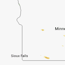
Minnesota
| Local Time | Report Details |
|---|---|
| 4:25 PM CDT | Quarter sized hail reported near Willmar, MN, 34.3 miles ENE of Montevideo, MN |
| 5:12 PM CDT | Recorded two wind gusts via vehicle anemometer of 58.2 and 61.2 the average sustained winds for approx 10 min was anywhere from 27-36 mph. no damage was observe in mcleod county MN, 59.2 miles W of Minneapolis, MN |
| 5:22 PM CDT | 58mph to 61mph wind gust measured from a car anemomete in mcleod county MN, 56.4 miles W of Minneapolis, MN |
| 5:30 PM CDT | Mesonet station winthrop 2 w /mn032/ in sibley county MN, 64 miles WSW of Minneapolis, MN |
| 5:45 PM CDT | Power out in town in mcleod county MN, 46.3 miles WSW of Minneapolis, MN |
| 5:45 PM CDT | Quarter sized hail reported near Shakopee, MN, 17.6 miles SW of Minneapolis, MN |
| 5:45 PM CDT | Quarter sized hail reported near Burnsville, MN, 15.8 miles S of Minneapolis, MN |
| 5:50 PM CDT | Golf Ball sized hail reported near Savage, MN, 15.8 miles SSW of Minneapolis, MN, estimated from photo posted on social media |
| 5:56 PM CDT | Quarter sized hail reported near Burnsville, MN, 15.1 miles S of Minneapolis, MN |
| 6:00 PM CDT | Ping Pong Ball sized hail reported near Burnsville, MN, 13.8 miles S of Minneapolis, MN |
| 6:00 PM CDT | Ping Pong Ball sized hail reported near Minneapolis, MN, 12.9 miles SSW of Minneapolis, MN |
| 6:00 PM CDT | Golf Ball sized hail reported near Burnsville, MN, 15.1 miles S of Minneapolis, MN |
| 6:00 PM CDT | Quarter sized hail reported near Burnsville, MN, 13.8 miles S of Minneapolis, MN |
| 6:00 PM CDT | Multiple limbs up to 8 in along county road 11 between echo park lane and county road 38...extends to 140th street at echo park in dakota county MN, 14.4 miles S of Minneapolis, MN |
| 6:01 PM CDT | Quarter sized hail reported near Burnsville, MN, 16.5 miles S of Minneapolis, MN |
| 6:07 PM CDT | Quarter sized hail reported near Saint Paul, MN, 16.7 miles S of Minneapolis, MN, 5 minutes of hail mixed with heavy wind driven rain. |
| 6:13 PM CDT | 6 inch tree down blocking road in dakota county MN, 15.2 miles S of Minneapolis, MN |
| 6:15 PM CDT | Large tree down on lynn ave and 126th street on the northeast side of savag in scott county MN, 14.9 miles SSW of Minneapolis, MN |
| 6:25 PM CDT | 3 to 4 inch branch across roa in sibley county MN, 42 miles WSW of Minneapolis, MN |
| 6:51 PM CDT | Awos station stanton ap /syn/ in goodhue county MN, 36.5 miles SSE of Minneapolis, MN |
| 6:52 PM CDT | Small tree limbs down and fire dept and responding to a transformer fir in dakota county MN, 26.2 miles SE of Minneapolis, MN |
| 7:08 PM CDT | Large tree limbs down 6 inches broken at the base from center of tre in dakota county MN, 18 miles S of Minneapolis, MN |
| 7:20 PM CDT | 3 to 4 foot diameter oak tree blown over. also reported 100 acres of corn and beans destroye in martin county MN, 71.8 miles WNW of Mason City, IA |
| 8:10 PM CDT | Number of trees damaged. relayed by medi in olmsted county MN, 60.8 miles NE of Mason City, IA |
| 9:07 PM CDT | Quarter sized hail reported near Spring Grove, MN, 26.1 miles SW of La Crosse, WI |
Nebraska
| Local Time | Report Details |
|---|---|
| 3:40 PM MDT | Storm damage reported in cherry county NE, 38 miles WSW of Valentine, NE |
| 5:30 PM CDT | Estimated winds of 70 to 80 mph with zero visibility. pastures flooded als in cherry county NE, 40.5 miles S of Valentine, NE |
| 4:49 PM MDT | Quarter sized hail reported near Scottsbluff, NE, 2.4 miles NW of Scottsbluff, NE, hail ranged from nickel size to quarter quarter size... |
| 4:52 PM MDT | Golf Ball sized hail reported near Gering, NE, 0.8 miles S of Scottsbluff, NE |
| 4:53 PM MDT | Quarter sized hail reported near Scottsbluff, NE, 0.6 miles NNE of Scottsbluff, NE |
| 4:53 PM MDT | Golf Ball sized hail reported near Scottsbluff, NE, 0.6 miles NNE of Scottsbluff, NE |
| 4:55 PM MDT | Quarter sized hail reported near Scottsbluff, NE, 2.6 miles N of Scottsbluff, NE, hail ranged from nickel size to quarter size. this was located 2 miles north of the air port. |
| 4:55 PM MDT | Quarter sized hail reported near Scottsbluff, NE, 1.7 miles E of Scottsbluff, NE, public reported hail damage to cars in perkins parking lot east of scottsbluff. |
| 6:00 PM CDT | Trees downed in brown county NE, 53.2 miles SSE of Valentine, NE |
| 6:00 PM CDT | 6 inch diameter branches down in blaine county NE, 61.1 miles SSE of Valentine, NE |
| 5:15 PM MDT | Quarter sized hail reported near Gering, NE, 10.7 miles SE of Scottsbluff, NE, hail to the size of quarters coving 50 percent of the ground. stones were very hard...and broke out one window of a residence. |
| 6:20 PM CDT | A lot of small tree branches down with pea size hail in blaine county NE, 59 miles NE of North Platte, NE |
| 6:22 PM CDT | Quarter sized hail reported near Shelby, NE, 53.6 miles ENE of Grand Island, NE, quarter sized hail lasted about 1 minute. |
| 6:25 PM CDT | Storm damage reported in loup county NE, 57.6 miles WSW of Oneill, NE |
| 5:30 PM MDT | Golf Ball sized hail reported near Bayard, NE, 17.3 miles SE of Scottsbluff, NE, hail was observed near hubbard gap south of mcgrew nebraska. |
| 6:45 PM CDT | Golf Ball sized hail reported near Central City, NE, 15.2 miles NE of Grand Island, NE, golf ball size hail near chapman. report relayed from facebook. |
| 7:03 PM CDT | Golf Ball sized hail reported near Oconto, NE, 50.3 miles E of North Platte, NE |
| 7:05 PM CDT | Quarter sized hail reported near Marquette, NE, 21.2 miles ENE of Grand Island, NE |
| 7:05 PM CDT | Quarter sized hail reported near Litchfield, NE, 45.3 miles WNW of Grand Island, NE, quarter size hail and 40 to 45 mph wind. |
| 7:25 PM CDT | Quarter sized hail reported near Eddyville, NE, 60.3 miles E of North Platte, NE, dimes to quarter size hail covering about 50 percent of the ground. |
| 7:40 PM CDT | Quarter sized hail reported near Waco, NE, 46.1 miles E of Grand Island, NE |
| 7:42 PM CDT | Quarter sized hail reported near Miller, NE, 55 miles W of Grand Island, NE, spotter went out and measured after the fact and reported quarter size hail. |
| 7:53 PM CDT | Quarter sized hail reported near Lincoln, NE, 53.2 miles SW of Omaha, NE |
| 8:05 PM CDT | Golf Ball sized hail reported near Sutton, NE, 30.7 miles SE of Grand Island, NE |
| 8:12 PM CDT | Quarter sized hail reported near Bennet, NE, 49.3 miles SW of Omaha, NE |
| 8:19 PM CDT | Quarter sized hail reported near Shickley, NE, 47.7 miles SE of Grand Island, NE, 50 mph winds and quarter sized hail. |
| 8:20 PM CDT | Ping Pong Ball sized hail reported near Hastings, NE, 23.1 miles S of Grand Island, NE |
| 8:36 PM CDT | Golf Ball sized hail reported near Bruning, NE, 57.5 miles SE of Grand Island, NE, golf ball and slightly larger hail ongoing for 5 minutes. 60 mph estimated wind gusts as well. |
| 8:38 PM CDT | Quarter sized hail reported near Wilber, NE, 75.9 miles SW of Omaha, NE, 45 mph winds also. |
| 8:45 PM CDT | Golf Ball sized hail reported near Clatonia, NE, 73 miles SW of Omaha, NE |
| 9:04 PM CDT | Spotter estimated wind speeds greater than 60 mp in jefferson county NE, 76.9 miles SE of Grand Island, NE |
| 9:05 PM CDT | Quarter sized hail reported near Fairbury, NE, 73.6 miles SE of Grand Island, NE |
| 9:30 PM CDT | Storm damage reported in gage county NE, 61.4 miles NNW of Manhattan, KS |
| 9:34 PM CDT | Quarter sized hail reported near Falls City, NE, 80.1 miles NE of Manhattan, KS |
Kentucky
| Local Time | Report Details |
|---|---|
| 4:50 PM CDT | Roof damage to 2 homes on chris ave in ne henderson county. 2 ft dia tree down on one home. roof peeled off part of 2nd home. numerous smaller trees and power line dama in henderson county KY, 8.8 miles SSE of Evansville, IN |
| 5:10 PM CDT | Time estimated by rada in henderson county KY, 9.5 miles S of Evansville, IN |
| 5:30 PM CDT | Large limbs reported down. one blocking a road. power lines reported down as wel in daviess county KY, 28.5 miles ESE of Evansville, IN |
| 5:40 PM CDT | Large tree limbs and power lines down. large tree limb blocking griffith ave east. utility pole across todd bridge roa in daviess county KY, 28.5 miles ESE of Evansville, IN |
| 6:02 PM CDT | Trees down in the deanefield area in ohio county KY, 47.6 miles ESE of Evansville, IN |
| 7:25 PM EDT | One tree down at sharon rd and black rock rd. time estimated from rada in carroll county KY, 38.1 miles SW of Cincinnati, OH |
| 7:42 PM EDT | Several trees reported down across the count in gallatin county KY, 30.1 miles SW of Cincinnati, OH |
| 8:00 PM EDT | Five boats damaged and three set adrift at smugglers cove marin in gallatin county KY, 30.5 miles SSW of Cincinnati, OH |
| 7:09 PM CDT | One downed tree blocking the road in hart county KY, 43.1 miles SSW of Louisville, KY |
| 7:15 PM CDT | Trees down across the county in hart county KY, 49.8 miles SSW of Louisville, KY |
| 8:20 PM EDT | Several trees down and a tree on a van at the intersection of westport road and herr lane in jefferson county KY, 18.6 miles NNE of Louisville, KY |
| 8:20 PM EDT | Several trees down and a tree on a van at the intersection of westport road and herr lane in jefferson county KY, 20 miles NNE of Louisville, KY |
| 8:20 PM EDT | A downburst with winds estimated at 65 mph downed several large mature trees at the westport condominiums just north of st mattthews. several trees fell across parked c in jefferson county KY, 16.1 miles N of Louisville, KY |
| 8:30 PM EDT | Report of house damage at washburn avenue and finley avenue in jefferson county KY, 20 miles NNE of Louisville, KY |
Ohio
| Local Time | Report Details |
|---|---|
| 6:05 PM EDT | One tree down in northern worthington. time estimated from rada in franklin county OH, 9.6 miles N of Columbus, OH |
| 6:05 PM EDT | Large limbs down near sr161 and us2 in franklin county OH, 8.9 miles N of Columbus, OH |
| 6:18 PM EDT | One large branch down on theori ave near clark state r in franklin county OH, 8.9 miles ENE of Columbus, OH |
| 6:18 PM EDT | Several large limbs down in the are in franklin county OH, 8 miles NE of Columbus, OH |
| 6:37 PM EDT | Several trees down around route 161 and route 31 in licking county OH, 19.4 miles ENE of Columbus, OH |
| 6:48 PM EDT | Quarter sized hail reported near Oxford, OH, 30.8 miles NNW of Cincinnati, OH |
| 6:52 PM EDT | A few trees down in licking county OH, 27.2 miles E of Columbus, OH |
| 8:20 PM EDT | Quarter sized hail reported near Wilmington, OH, 38.9 miles NE of Cincinnati, OH |
| 8:20 PM EDT | Quarter sized hail reported near Clarksville, OH, 37.6 miles NE of Cincinnati, OH |
| 8:25 PM EDT | Some trees and powerlines dow in lake county OH, 22.6 miles NE of Cleveland, OH |
| 8:25 PM EDT | Some trees dow in lake county OH, 17.7 miles NE of Cleveland, OH |
| 8:26 PM EDT | Quarter sized hail reported near Wilmington, OH, 38.9 miles NE of Cincinnati, OH |
| 8:27 PM EDT | Quarter sized hail reported near Wilmington, OH, 39.3 miles NE of Cincinnati, OH |
| 8:28 PM EDT | Half Dollar sized hail reported near Wilmington, OH, 40.2 miles NE of Cincinnati, OH |
| 9:15 PM EDT | A few large limbs down in munson townshi in geauga county OH, 25.2 miles E of Cleveland, OH |
Iowa
| Local Time | Report Details |
|---|---|
| 6:28 PM CDT | Quarter sized hail reported near Glenwood, IA, 19.9 miles SE of Omaha, NE |
| 7:15 PM CDT | Creston awos measured a peak wind gust of 52 kts in union county IA, 55.2 miles SW of Des Moines, IA |
| 7:35 PM CDT | 50 to 60 mph winds with pea size hai in fremont county IA, 39.2 miles SSE of Omaha, NE |
| 8:01 PM CDT | Lamoni asos measured peak wind gust of 55 kts in decatur county IA, 67.9 miles SSW of Des Moines, IA |
| 8:02 PM CDT | Lamoni asos measured peak wind gust of 64 kts in decatur county IA, 67.9 miles SSW of Des Moines, IA |
Connecticut
| Local Time | Report Details |
|---|---|
| 7:33 PM EDT | Trees down in litchfield county CT, 68.9 miles NNE of Brooklyn, NY |
| 8:00 PM EDT | Several trees and wires down across tow in fairfield county CT, 60.6 miles NE of Brooklyn, NY |
| 8:05 PM EDT | Tree down through the roof of garage on baldwin stree in new haven county CT, 77.7 miles NE of Brooklyn, NY |
| 8:10 PM EDT | Tree down across maple ridge roa in new haven county CT, 77.7 miles NE of Brooklyn, NY |
| 8:15 PM EDT | Large tree down blocking byam road at west waterbury roa in new haven county CT, 79.4 miles NE of Brooklyn, NY |
| 8:30 PM EDT | Large tree down blocking west johnson avenue and knotter driv in new haven county CT, 79.6 miles WSW of Providence, RI |
North Dakota
| Local Time | Report Details |
|---|---|
| 6:48 PM CDT | The wind gust was measured at the grand forks airpor in grand forks county ND, 74.5 miles NNW of Fargo, ND |
Missouri
| Local Time | Report Details |
|---|---|
| 6:50 PM CDT | Quarter sized hail reported near Saint Louis, MO, 7.5 miles WSW of Saint Louis, MO |
| 6:57 PM CDT | Half Dollar sized hail reported near Saint Louis, MO, 8.9 miles SW of Saint Louis, MO |
| 6:58 PM CDT | Half Dollar sized hail reported near Saint Louis, MO, 2.3 miles WNW of Saint Louis, MO, south saint louis city. |
| 6:58 PM CDT | Golf Ball sized hail reported near Saint Louis, MO, 8 miles SSW of Saint Louis, MO |
| 7:01 PM CDT | Hen Egg sized hail reported near Saint Louis, MO, 8.9 miles SW of Saint Louis, MO |
| 7:05 PM CDT | Quarter sized hail reported near Saint Louis, MO, 2.3 miles WNW of Saint Louis, MO, walsh st. and mackland ave |
| 7:22 PM CDT | Quarter sized hail reported near Saint Louis, MO, 11 miles SW of Saint Louis, MO |
| 7:23 PM CDT | Golf Ball sized hail reported near Saint Louis, MO, 11 miles SW of Saint Louis, MO |
| 7:25 PM CDT | Half Dollar sized hail reported near Saint Louis, MO, 11 miles SW of Saint Louis, MO |
| 7:26 PM CDT | Half Dollar sized hail reported near Saint Louis, MO, 14.5 miles SSW of Saint Louis, MO |
| 7:28 PM CDT | Half Dollar sized hail reported near Saint Louis, MO, 11 miles SW of Saint Louis, MO |
| 7:48 PM CDT | Storm damage reported in worth county MO, 86.4 miles SE of Omaha, NE |
| 8:00 PM CDT | Hen Egg sized hail reported near Cedar Hill, MO, 29.9 miles SW of Saint Louis, MO |
| 8:11 PM CDT | Quarter sized hail reported near House Springs, MO, 24.7 miles SW of Saint Louis, MO |
| 8:14 PM CDT | Ping Pong Ball sized hail reported near Imperial, MO, 20.3 miles SSW of Saint Louis, MO |
| 8:24 PM CDT | Ping Pong Ball sized hail reported near House Springs, MO, 29 miles SW of Saint Louis, MO |
| 8:28 PM CDT | Storm damage reported in mercer county MO, 74.6 miles S of Des Moines, IA |
| 8:33 PM CDT | Trees down blocking route b 2 south of cansvill in harrison county MO, 81.8 miles S of Des Moines, IA |
| 8:38 PM CDT | Via social media in harrison county MO, 85.7 miles NNE of Kansas City, MO |
| 8:40 PM CDT | Trees down 2-3 miles south of bethany... blocking route 69 at the s curves in harrison county MO, 82.5 miles NNE of Kansas City, MO |
| 8:47 PM CDT | 2-4 inch diameter tree limbs down in harrison county MO, 85.7 miles NNE of Kansas City, MO |
| 8:48 PM CDT | Storm damage reported in harrison county MO, 81 miles NNE of Kansas City, MO |
| 9:04 PM CDT | Large tree limb down on lulu s in grundy county MO, 85.4 miles NE of Kansas City, MO |
| 9:04 PM CDT | Large tree limb down on lulu s in grundy county MO, 85.4 miles NE of Kansas City, MO |
| 9:14 PM CDT | Tree limbs down in buchanan county MO, 46.9 miles NNW of Kansas City, MO |
| 9:15 PM CDT | Several trees and large limbs down in sullivan county MO, 75.5 miles W of Kahoka, MO |
| 9:18 PM CDT | Large tree flown down on crowder road. whole tree was snapped of in grundy county MO, 85.4 miles NE of Kansas City, MO |
| 9:30 PM CDT | 3-4 inch diameter tree limbs down in dekalb county MO, 47.6 miles NNE of Kansas City, MO |
| 9:32 PM CDT | Storm damage reported in dekalb county MO, 47.6 miles NNE of Kansas City, MO |
| 9:34 PM CDT | Large limb down on locust st in livingston county MO, 72.8 miles NE of Kansas City, MO |
| 9:45 PM CDT | Trees down on hh. also trees down at b and e hwys near ridgely... mo in platte county MO, 19.2 miles NNW of Kansas City, MO |
| 9:45 PM CDT | Tree on house on route w in caldwell county MO, 49.2 miles NNE of Kansas City, MO |
| 9:55 PM CDT | Storm damage reported in macon county MO, 54 miles SW of Kahoka, MO |
| 10:02 PM CDT | Storm damage reported in linn county MO, 62.4 miles NNW of Columbia, MO |
| 10:13 PM CDT | Large tree down b highway and covered bridge road in platte county MO, 20 miles N of Kansas City, MO |
| 10:22 PM CDT | Filled watercans blown off porch in clay county MO, 19.1 miles N of Kansas City, MO |
| 10:25 PM CDT | Tree down across a gravel road in shelby county MO, 43.3 miles SSW of Kahoka, MO |
| 10:30 PM CDT | Shingles were blown off the spotters hom in shelby county MO, 36.2 miles SSW of Kahoka, MO |
| 10:30 PM CDT | Tree limbs down in shelby county MO, 45.4 miles SSW of Kahoka, MO |
| 10:35 PM CDT | Storm damage reported in clay county MO, 11.7 miles N of Kansas City, MO |
| 10:35 PM CDT | Numerous reports of tree limbs and power lines down across southern knox count in knox county MO, 36.8 miles SSW of Kahoka, MO |
| 10:40 PM CDT | Large tree down on mckenzie street in randolph county MO, 32.8 miles N of Columbia, MO |
| 10:42 PM CDT | Multiple tree limbs dow in clay county MO, 7.5 miles N of Kansas City, MO |
| 10:46 PM CDT | Large limb down in la bell in lewis county MO, 23.1 miles SSW of Kahoka, MO |
| 10:49 PM CDT | Storm damage reported in platte county MO, 10.1 miles NNW of Kansas City, MO |
| 10:50 PM CDT | Power lines down in lewis county MO, 23.1 miles SSW of Kahoka, MO |
| 10:52 PM CDT | Storm damage reported in saline county MO, 58.5 miles W of Columbia, MO |
| 10:52 PM CDT | Powerlines down in saline county MO, 48 miles WNW of Columbia, MO |
| 11:03 PM CDT | Estimated at grandview triangle in jackson county MO, 15.8 miles SSE of Kansas City, MO |
| 11:10 PM CDT | 20 to 30 trees and numerous power lines reported down county-wide in howard county MO, 23.5 miles NW of Columbia, MO |
| 11:12 PM CDT | Storm damage reported in pettis county MO, 51.4 miles WSW of Columbia, MO |
| 11:16 PM CDT | Storm damage reported in pettis county MO, 51.4 miles WSW of Columbia, MO |
| 11:18 PM CDT | Loss of power in the area in pettis county MO, 51.4 miles WSW of Columbia, MO |
| 11:21 PM CDT | Storm damage reported in jackson county MO, 17.3 miles ESE of Kansas City, MO |
| 11:25 PM CDT | Numerous large trees blocking roads and power lines down across columbia...mainly in western and southern sections of town in boone county MO, 0.3 miles SE of Columbia, MO |
| 11:27 PM CDT | Storm damage reported in cass county MO, 19.7 miles S of Kansas City, MO |
| 11:28 PM CDT | University of missouri south far in boone county MO, 4.5 miles SE of Columbia, MO |
| 11:30 PM CDT | Stop sign blown over at highway 61 and route hh in ralls county MO, 54.4 miles SSE of Kahoka, MO |
| 11:35 PM CDT | Store front windows broken out of 3 stores and several cars move in marion county MO, 52.2 miles SSE of Kahoka, MO |
| 11:35 PM CDT | Numerous trees down...power lines down and power poles snappe in audrain county MO, 29.1 miles ENE of Columbia, MO |
| 11:35 PM CDT | Stop sign blown over at route hh and u.s. highway 6 in ralls county MO, 53.9 miles SSE of Kahoka, MO |
| 11:40 PM CDT | Multiple trees down at garden hill mobile home park. tree into structure with structural damag in cass county MO, 43 miles SSE of Kansas City, MO |
| 11:45 PM CDT | Estimated 60-70mph winds... with tree blown down on south side of jefferson cit in cole county MO, 27.5 miles SSE of Columbia, MO |
| 11:48 PM CDT | Storm damage reported in cole county MO, 27.5 miles SSE of Columbia, MO |
| 11:50 PM CDT | Hand held observatio in cole county MO, 27.5 miles SSE of Columbia, MO |
| 11:50 PM CDT | Tree limbs down on numerous streets thoughout the county. numerous power outages reporte in callaway county MO, 21.9 miles ESE of Columbia, MO |
| 11:50 PM CDT | Traffic light blown down in downtown hannibal. several store front windows shattere in marion county MO, 52.2 miles SSE of Kahoka, MO |
| 11:55 PM CDT | Trees down in versailles in morgan county MO, 45.2 miles SW of Columbia, MO |
| 11:57 PM CDT | Caller could hear limbs cracking. bbq pit was blown across yar in montgomery county MO, 44.4 miles E of Columbia, MO |
| 11:58 PM CDT | Trees and power lines down. shed destroye in audrain county MO, 51.6 miles ENE of Columbia, MO |
| 11:58 PM CDT | Power lines down in ralls county MO, 57.8 miles NE of Columbia, MO |
| 12:00 AM CDT | Roof lifted off a building with debris in the air. time estimated from rada in audrain county MO, 51.6 miles ENE of Columbia, MO |
| 12:00 AM CDT | Several power lines down and trees down in montgomery county MO, 44.4 miles E of Columbia, MO |
| 12:05 AM CDT | Tree limbs down blocking route a in osage county MO, 33.2 miles SE of Columbia, MO |
| 12:05 AM CDT | Tree down blocking road at highway 161 and route v in montgomery county MO, 49.8 miles E of Columbia, MO |
| 12:07 AM CDT | Numerous limbs up to 3 inches in diameter and up to 20 feet long down on city roadway in montgomery county MO, 44.4 miles E of Columbia, MO |
| 12:08 AM CDT | Power lines down in ralls county MO, 60.4 miles SSE of Kahoka, MO |
| 12:17 AM CDT | Trees down in eldo in miller county MO, 43.6 miles SSW of Columbia, MO |
| 12:18 AM CDT | Trees down in several locations along route in pike county MO, 61.5 miles ENE of Columbia, MO |
| 12:20 AM CDT | Tree blown down. report from faceboo in camden county MO, 58.5 miles SSW of Columbia, MO |
| 12:24 AM CDT | Tree was down at highway a and pin oak church roa in warren county MO, 58.9 miles E of Columbia, MO |
| 12:24 AM CDT | Several trees dow in pike county MO, 66.5 miles ENE of Columbia, MO |
| 12:25 AM CDT | Storm damage reported in warren county MO, 52.5 miles WNW of Saint Louis, MO |
| 12:30 AM CDT | Power lines down in meta... a tree was blown into a residence at bonnets mill... and multiple mail boxes were damaged in lin in osage county MO, 42.1 miles SE of Columbia, MO |
| 12:30 AM CDT | Storm damage reported in franklin county MO, 51.8 miles NNE of Salem, MO |
| 12:44 AM CDT | Storm damage reported in warren county MO, 43.4 miles W of Saint Louis, MO |
| 12:45 AM CDT | Tree blown down at highway bb and farm road 61. time estimate in greene county MO, 18.4 miles NW of Springfield, MO |
| 12:54 AM CDT | Storm damage reported in lincoln county MO, 48.6 miles WNW of Saint Louis, MO |
| 1:05 AM CDT | Wind estimated 50 to 60 mph in st. louis county MO, 20.6 miles W of Saint Louis, MO |
| 1:25 AM CDT | Highway sign blown over and blocking highway 5 in vernon county MO, 61.3 miles E of Chanute, KS |
| 1:40 AM CDT | Tree down and partially blocking highway d in vernon county MO, 63.7 miles E of Chanute, KS |
| 1:45 AM CDT | Tree blown down at highway bb and farm road 61. time estimate in greene county MO, 18.4 miles NW of Springfield, MO |
| 2:13 AM CDT | Tree blown down blocking highway 16 in greene county MO, 17.6 miles WNW of Springfield, MO |
| 2:18 AM CDT | Power out in republi in greene county MO, 12.2 miles WSW of Springfield, MO |
| 2:19 AM CDT | 6-inch tree limb blown dow in greene county MO, 0.6 miles S of Springfield, MO |
| 2:24 AM CDT | Power lines down at fort and nichol in greene county MO, 0.6 miles S of Springfield, MO |
South Carolina
| Local Time | Report Details |
|---|---|
| 7:55 PM EDT | Quarter sized hail reported near Harleyville, SC, 25.4 miles W of Charleston, SC, quarter size hail reported in harleyville. |
| 7:57 PM EDT | Quarter sized hail reported near Harleyville, SC, 25.4 miles W of Charleston, SC, local police reported quarter size hail in harleyville. hail ended around 805 pm. |
Texas
| Local Time | Report Details |
|---|---|
| 7:20 PM CDT | Trees down. part of metal roof stripped off buildin in harris county TX, 27.8 miles NNW of Houston, TX |
Colorado
| Local Time | Report Details |
|---|---|
| 8:04 PM MDT | Quarter sized hail reported near Agate, CO, 59.3 miles ESE of Denver, CO |
| 8:09 PM MDT | Quarter sized hail reported near Agate, CO, 57.3 miles ESE of Denver, CO |
| 8:09 PM MDT | Ping Pong Ball sized hail reported near Boulder, CO, 21.9 miles NNW of Denver, CO |
| 8:15 PM MDT | Half Dollar sized hail reported near Louisville, CO, 17.7 miles NNW of Denver, CO |
| 8:18 PM MDT | Quarter sized hail reported near Louisville, CO, 17.7 miles NNW of Denver, CO |
| 8:35 PM MDT | Four to six inch diameter tree branches broken in jefferson county CO, 8.4 miles NW of Denver, CO |
| 8:38 PM MDT | Half Dollar sized hail reported near Arvada, CO, 8.4 miles NW of Denver, CO |
| 8:39 PM MDT | Golf Ball sized hail reported near Arvada, CO, 10.1 miles NW of Denver, CO |
| 8:40 PM MDT | Quarter sized hail reported near Arvada, CO, 8.4 miles NW of Denver, CO |
| 8:42 PM MDT | Half Dollar sized hail reported near Arvada, CO, 8.4 miles NW of Denver, CO, 52nd and ward |
| 8:45 PM MDT | Greater than two inch diameter tree brances broken in arapahoe county CO, 10.8 miles SSW of Denver, CO |
| 9:25 PM MDT | Greater than two inch diameter tree brances broken in arapahoe county CO, 10.8 miles SSW of Denver, CO |
Nevada
| Local Time | Report Details |
|---|---|
| 9:10 PM PDT | 58 mph gust recorded at sierra vista hs at 910 pm in clark county NV, 13.3 miles SSW of Las Vegas, NV |
Connect with Interactive Hail Maps