

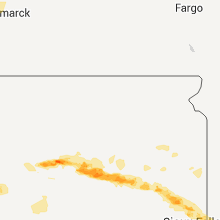
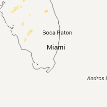
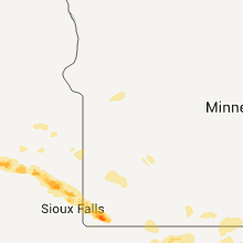
Hail Map for Friday, June 19, 2015

Number of Impacted Households on 6/19/2015
0
Impacted by 1" or Larger Hail
0
Impacted by 1.75" or Larger Hail
0
Impacted by 2.5" or Larger Hail
Square Miles of Populated Area Impacted on 6/19/2015
0
Impacted by 1" or Larger Hail
0
Impacted by 1.75" or Larger Hail
0
Impacted by 2.5" or Larger Hail


Cities Most Affected by Hail Storms of 6/19/2015
| Hail Size | Demographics of Zip Codes Affected | ||||||
|---|---|---|---|---|---|---|---|
| City | Count | Average | Largest | Pop Density | House Value | Income | Age |
| Marmarth, ND | 3 | 2.75 | 2.75 | 0 | $12k | $28.6k | 42.8 |
| Hammond, MT | 2 | 3.38 | 4.25 | 0 | $71k | $14.6k | 45.5 |
| Olive, MT | 2 | 2.25 | 2.75 | 0 | $58k | $36.5k | 42.5 |
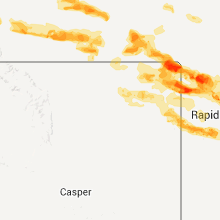
| Newell, SD | 1 | 4.50 | 4.50 | 1 | $38k | $25.9k | 47.2 |
| Saint Onge, SD | 1 | 4.50 | 4.50 | 6 | $50k | $25.7k | 46.4 |
| Nisland, SD | 2 | 2.13 | 2.50 | 3 | $25k | $23.9k | 49.8 |
| Holabird, SD | 2 | 1.88 | 2.00 | 1 | $19k | $42.0k | 43.0 |
| Huron, SD | 2 | 1.75 | 1.75 | 47 | $59k | $30.0k | 40.5 |
| Dell Rapids, SD | 2 | 1.75 | 1.75 | 39 | $94k | $44.3k | 36.0 |
| Spearfish, SD | 1 | 3.00 | 3.00 | 62 | $98k | $30.2k | 38.6 |
| Vale, SD | 1 | 2.75 | 2.75 | 2 | $28k | $33.5k | 47.5 |
| Alzada, MT | 1 | 2.75 | 2.75 | 0 | $138k | $33.8k | 52.5 |
| Lame Deer, MT | 1 | 2.50 | 2.50 | 0 | $48k | $23.3k | 23.7 |
| Baker, MT | 1 | 2.50 | 2.50 | 0 | $49k | $30.7k | 42.1 |
| Hermosa, SD | 1 | 2.25 | 2.25 | 3 | $127k | $35.4k | 44.4 |
| Ashland, MT | 1 | 2.00 | 2.00 | 0 | $51k | $27.0k | 34.1 |
| Busby, MT | 1 | 2.00 | 2.00 | 0 | $49k | $27.9k | 22.9 |
| Hill City, SD | 1 | 2.00 | 2.00 | 3 | $97k | $36.2k | 47.3 |
| Volborg, MT | 1 | 1.75 | 1.75 | 0 | $106k | $36.3k | 48.7 |
| Keystone, SD | 1 | 1.75 | 1.75 | 9 | $97k | $31.4k | 50.6 |
| Loring, MT | 1 | 1.75 | 1.75 | 0 | $43k | $26.3k | 43.0 |
| Fairview, MT | 1 | 1.75 | 1.75 | 3 | $41k | $32.1k | 41.3 |
| Cartwright, ND | 1 | 1.75 | 1.75 | 1 | $28k | $30.7k | 44.5 |
| Billings, MT | 1 | 1.75 | 1.75 | 75 | $81k | $26.8k | 34.8 |
| Garryowen, MT | 1 | 1.75 | 1.75 | 0 | $76k | $55.9k | 30.3 |
| Rhame, ND | 1 | 1.75 | 1.75 | 0 | $31k | $22.9k | 47.0 |
| Ellsworth, MN | 1 | 1.75 | 1.75 | 12 | $32k | $31.9k | 46.8 |
Hail and Wind Damage Spotted on 6/19/2015
Filter by Report Type:Hail ReportsWind Reports
States Impacted
Tennessee, North Carolina, Illinois, South Dakota, Montana, Kentucky, Florida, South Carolina, New Mexico, Virginia, Indiana, North Dakota, Oklahoma, Georgia, Wyoming, Minnesota, NebraskaTennessee
| Local Time | Report Details |
|---|---|
| 1:05 PM EDT | Numerous trees down along dry valley rd. and chatata valley rd. south of charleston. pea sized hail was reported as wel in bradley county TN, 35 miles ENE of Chattanooga, TN |
| 4:40 PM CDT | One mobile home destroyed several homes damaged. multiple trees down some on homes. damage concentraited around guthrie road and north poplar st. funnel cloud reporte in henry county TN, 17.9 miles NE of Mc Kenzie, TN |
| 6:00 PM EDT | Quarter sized hail reported near Greeneville, TN, 45.1 miles SW of Bristol, TN |
| 6:51 PM CDT | Trees down across southwestern portions of county in macon county TN, 43.7 miles ENE of Nashville, TN |
North Carolina
| Local Time | Report Details |
|---|---|
| 1:22 PM EDT | First report. several trees down around mill spring and near columbus. trees down on moore rd...john shehan rd...and near polk central schoo in polk county NC, 40.9 miles NE of Greenville, SC |
| 2:15 PM EDT | A few isolated trees down along polly spout rd. also small hail in vein mountain communit in mcdowell county NC, 61.1 miles NE of Greenville, SC |
| 3:28 PM EDT | Many tree branches blown down with at least a few of them being at least 2 inches in diamete in burke county NC, 54.3 miles NW of Charlotte, NC |
| 3:28 PM EDT | 3 feet diameter tree on rutherford college down and post office signs bent to 45 degree angle. exit 114 off interstate 40...many tree limbs of 2 to 3 inches diameter do in burke county NC, 52.1 miles NW of Charlotte, NC |
| 3:37 PM EDT | Quarter sized hail reported near Denton, NC, 55.3 miles ENE of Charlotte, NC, quarter size hail reported at nc hwy 49 and brantley gordon rd... time estimated by radar |
| 4:07 PM EDT | Quarter sized hail reported near Mooresville, NC, 22.3 miles N of Charlotte, NC, report of quarter sized hail along brawley school road. |
| 4:13 PM EDT | Trees down at intersection of highway 21 and huntington roa in iredell county NC, 23.3 miles N of Charlotte, NC |
| 4:22 PM EDT | Two trees dow in iredell county NC, 22.6 miles N of Charlotte, NC |
| 4:27 PM EDT | Trees dow in iredell county NC, 24.7 miles N of Charlotte, NC |
| 4:39 PM EDT | Trees and power lines down on neel r in rowan county NC, 34.3 miles NNE of Charlotte, NC |
| 4:40 PM EDT | Tree down in grays greek... time estimated by radar in cumberland county NC, 61.5 miles SSW of Raleigh, NC |
| 4:50 PM EDT | Many trees down at the intersection of sherrills ford road and highway 15 in rowan county NC, 34.8 miles NNE of Charlotte, NC |
| 4:53 PM EDT | At least 6 trees down in salisbury with one falling on a railroad track near the amtrak statio in rowan county NC, 36.9 miles NNE of Charlotte, NC |
| 4:55 PM EDT | Metal and wood roof blown off a business... limbs 2 inches in diameter down... time estimated by radar in moore county NC, 58.2 miles WSW of Raleigh, NC |
| 5:15 PM EDT | Large hickory tree down along parkton-tobermory rd near thumper r in robeson county NC, 65.8 miles SSW of Raleigh, NC |
| 5:22 PM EDT | Several trees down near where highway 64 crosses over into davidson count in davie county NC, 50.7 miles NNE of Charlotte, NC |
| 5:40 PM EDT | One tree down and large limbs down on power line in cabarrus county NC, 11.3 miles ENE of Charlotte, NC |
| 5:45 PM EDT | Tree down at arnold road... time estimated by radar in davidson county NC, 55.4 miles NNE of Charlotte, NC |
| 6:48 PM EDT | Quarter sized hail reported near Jacksonville, NC, 47.8 miles NE of Wilmington, NC, social media report of quarter-size hail in jacksonville. |
| 6:50 PM EDT | Quarter sized hail reported near Jacksonville, NC, 47.8 miles NE of Wilmington, NC, onslow 911 center reports nickel to quarter size hail at their location. public reports via media of 1 inch hail as well. |
| 7:32 PM EDT | Part of roof blown off a car dealership damaging a few cars. time estimated based off rada in new hanover county NC, 5.6 miles E of Wilmington, NC |
| 7:48 PM EDT | Power line down... time estimated by radar in cumberland county NC, 51.1 miles SSW of Raleigh, NC |
| 7:48 PM EDT | Power line down... time estimated by radar in cumberland county NC, 55.1 miles SSW of Raleigh, NC |
| 7:50 PM EDT | Tree down... time estimated by radar in cumberland county NC, 53.1 miles SSW of Raleigh, NC |
| 7:55 PM EDT | Tree down... time estimated by radar in cumberland county NC, 53.7 miles SSW of Raleigh, NC |
| 7:55 PM EDT | Tree down... time estimated by radar in cumberland county NC, 48.6 miles S of Raleigh, NC |
| 7:55 PM EDT | Tree down... time estimated by radar in cumberland county NC, 57.5 miles SSW of Raleigh, NC |
| 7:56 PM EDT | Several trees reported down on raeford road... time estimated by radar in cumberland county NC, 53.1 miles SSW of Raleigh, NC |
| 8:00 PM EDT | Tree down... time estimated by radar in cumberland county NC, 50.1 miles S of Raleigh, NC |
| 8:00 PM EDT | Tree down... time estimated by radar in cumberland county NC, 57.5 miles SSW of Raleigh, NC |
| 8:03 PM EDT | Tree down... time estimated by radar in cumberland county NC, 49 miles S of Raleigh, NC |
| 8:05 PM EDT | Trees down... time estimated by radar in cumberland county NC, 58 miles S of Raleigh, NC |
| 8:26 PM EDT | Trees down at mile marker 1 interstate 85 northboun in cleveland county NC, 33.2 miles W of Charlotte, NC |
Illinois
| Local Time | Report Details |
|---|---|
| 12:30 PM CDT | Two barns destroye in marion county IL, 68.3 miles SSW of Mattoon, IL |
| 4:55 PM CDT | Severe roof damage at buisness in the community. structure is a poll bar in jackson county IL, 34.1 miles NNE of Cape Girardeau, MO |
| 4:55 PM CDT | Severe roof damage at hotel in the communit in jackson county IL, 34.1 miles NNE of Cape Girardeau, MO |
South Dakota
| Local Time | Report Details |
|---|---|
| 1:05 PM CDT | Hen Egg sized hail reported near Holabird, SD, 42.5 miles ENE of Pierre, SD |
| 2:27 PM CDT | Quarter sized hail reported near Miller, SD, 64.9 miles ENE of Pierre, SD, radar estimated time |
| 2:45 PM CDT | Quarter sized hail reported near Ree Heights, SD, 58 miles ENE of Pierre, SD, junction hwy 14 and ree heights corner. |
| 3:00 PM CDT | Golf Ball sized hail reported near Holabird, SD, 41.5 miles ENE of Pierre, SD |
| 3:00 PM CDT | 60 mph winds blew golfball size hail into the siding of the house causing numerous hole in hyde county SD, 41.5 miles ENE of Pierre, SD |
| 3:01 PM CDT | Quarter sized hail reported near Miller, SD, 67.8 miles E of Pierre, SD, relayed from hand conuty em. |
| 3:30 PM CDT | Quarter sized hail reported near Holabird, SD, 41.5 miles ENE of Pierre, SD |
| 3:31 PM CDT | Quarter sized hail reported near Wessington, SD, 71.7 miles S of Aberdeen, SD |
| 4:10 PM CDT | Golf Ball sized hail reported near Huron, SD, 76.6 miles S of Aberdeen, SD |
| 4:12 PM CDT | Half Dollar sized hail reported near Huron, SD, 75.4 miles S of Aberdeen, SD |
| 4:15 PM CDT | Golf Ball sized hail reported near Huron, SD, 77.1 miles S of Aberdeen, SD |
| 4:20 PM CDT | Quarter sized hail reported near Huron, SD, 77.1 miles S of Aberdeen, SD, social media report |
| 4:21 PM CDT | Quarter sized hail reported near Huron, SD, 76.5 miles S of Aberdeen, SD |
| 4:24 PM CDT | Quarter sized hail reported near Huron, SD, 77.1 miles S of Aberdeen, SD, social media report |
| 5:47 PM CDT | Storm damage reported in lake county SD, 36.5 miles NNW of Sioux Falls, SD |
| 6:50 PM CDT | Golf Ball sized hail reported near Dell Rapids, SD, 19.7 miles N of Sioux Falls, SD |
| 6:52 PM CDT | Golf Ball sized hail reported near Dell Rapids, SD, 19.7 miles N of Sioux Falls, SD |
| 7:30 PM MDT | Storm damage reported in butte county SD, 63.8 miles NW of Rapid City, SD |
| 8:08 PM MDT | Quarter sized hail reported near Nisland, SD, 50.8 miles NNW of Rapid City, SD |
| 8:13 PM MDT | Golf Ball sized hail reported near Nisland, SD, 50.8 miles NNW of Rapid City, SD, broken windows |
| 8:20 PM MDT | Softball sized hail reported near Newell, SD, 42.3 miles NNW of Rapid City, SD, multiple windows broken in house |
| 8:20 PM MDT | Multiple windows broken in house in butte county SD, 42.3 miles NNW of Rapid City, SD |
| 8:20 PM MDT | Storm damage reported in butte county SD, 44.6 miles NNW of Rapid City, SD |
| 8:25 PM MDT | Softball sized hail reported near Saint Onge, SD, 43 miles NW of Rapid City, SD |
| 8:30 PM MDT | Baseball sized hail reported near Vale, SD, 37.2 miles NNW of Rapid City, SD |
| 8:30 PM MDT | Tea Cup sized hail reported near Spearfish, SD, 46.5 miles NW of Rapid City, SD |
| 8:30 PM MDT | Tennis Ball sized hail reported near Nisland, SD, 44.4 miles NNW of Rapid City, SD, combined with wind gusts of 60-70mph... 5 windows were broken |
| 8:30 PM MDT | Estimated 60-70 mph winds. neighbor lost roof of bar in butte county SD, 44.4 miles NNW of Rapid City, SD |
| 10:10 PM MDT | Storm damage reported in ziebach county SD, 71.6 miles ENE of Rapid City, SD |
| 10:20 PM MDT | Hen Egg sized hail reported near Hill City, SD, 19.9 miles WSW of Rapid City, SD, report via twitter |
| 10:30 PM MDT | Golf Ball sized hail reported near Keystone, SD, 16.2 miles SW of Rapid City, SD, report via twitter |
| 10:30 PM MDT | Quarter sized hail reported near Keystone, SD, 16.4 miles SSW of Rapid City, SD, mostly pea size with a few quarter size hail |
| 10:48 PM MDT | Hen Egg sized hail reported near Hermosa, SD, 16.9 miles S of Rapid City, SD, report via twitter |
| 12:15 AM CDT | Semi blown over...machine shed destroyed...powerlines down in jones county SD, 43.9 miles SW of Pierre, SD |
| 11:20 PM MDT | Storm damage reported in pennington county SD, 51.3 miles ESE of Rapid City, SD |
| 12:22 AM CDT | Storm damage reported in jones county SD, 42 miles SW of Pierre, SD |
| 12:25 AM CDT | Storm damage reported in jones county SD, 40.2 miles SW of Pierre, SD |
| 12:27 AM CDT | Power flashe in jones county SD, 35.5 miles SSW of Pierre, SD |
| 12:30 AM CDT | 16-18 inch trees broke at base...lots of branches down in town in jones county SD, 37.6 miles SSW of Pierre, SD |
| 12:30 AM CDT | Storm damage reported in lyman county SD, 17.4 miles S of Pierre, SD |
| 12:33 AM CDT | Estimated eighty mph winds with a couple flipped trailers in jones county SD, 35.9 miles SSW of Pierre, SD |
| 12:40 AM CDT | Storm damage reported in hughes county SD, 16.5 miles ENE of Pierre, SD |
| 12:41 AM CDT | Pierre airport asos in hughes county SD, 1.5 miles E of Pierre, SD |
| 1:05 AM CDT | Estimated 90 mph winds flipped over a pickup truck. large area of shingles blown off roof with large tree branches downe in lyman county SD, 35 miles SE of Pierre, SD |
| 1:05 AM CDT | Winds estimated at 75 to 80 mph...shingle damage to roof in lyman county SD, 37.1 miles SE of Pierre, SD |
| 1:10 AM CDT | Storm damage reported in tripp county SD, 42.9 miles NE of Valentine, NE |
| 1:15 AM CDT | Storm damage reported in tripp county SD, 48.9 miles NE of Valentine, NE |
| 1:15 AM CDT | At big bend dam campers flipped...trees down...trailer home flipped...downed power lines...some trees fell on homes in buffalo county SD, 51.6 miles ESE of Pierre, SD |
| 1:25 AM CDT | Storm damage reported in lyman county SD, 60.7 miles SE of Pierre, SD |
| 1:30 AM CDT | Storm damage reported in brule county SD, 64.2 miles SE of Pierre, SD |
| 1:36 AM CDT | Estimated eighty mph winds caused damage to roof of hotel with a street sign snapped. freeway boom also snappe in lyman county SD, 61.5 miles SE of Pierre, SD |
| 1:49 AM CDT | Storm damage reported in charles mix county SD, 68.5 miles NNW of Oneill, NE |
| 1:49 AM CDT | Trees down in gregory county SD, 68.7 miles NNW of Oneill, NE |
| 1:52 AM CDT | Trees down in charles mix county SD, 65.1 miles N of Oneill, NE |
| 1:59 AM CDT | Storm damage reported in jerauld county SD, 82.9 miles ESE of Pierre, SD |
| 3:10 AM CDT | Large tree downed on main street in minnehaha county SD, 19.6 miles NNW of Sioux Falls, SD |
Montana
| Local Time | Report Details |
|---|---|
| 12:45 PM MDT | Quarter sized hail reported near Peerless, MT, 38.9 miles NE of Glasgow, MT, hail covered ground |
| 1:45 PM MDT | Quarter sized hail reported near Peerless, MT, 38.9 miles NE of Glasgow, MT, hail covered ground |
| 2:25 PM MDT | Ping Pong Ball sized hail reported near Wolf Point, MT, 43.2 miles ENE of Glasgow, MT |
| 2:40 PM MDT | Ping Pong Ball sized hail reported near Wolf Point, MT, 56.5 miles ENE of Glasgow, MT |
| 3:00 PM MDT | Quarter sized hail reported near Forsyth, MT, 51.9 miles SW of Miles City, MT, public reported quarter size hail. |
| 3:05 PM MDT | Storm damage reported in garfield county MT, 60.2 miles NNW of Miles City, MT |
| 3:11 PM MDT | Awos at poplar airport in roosevelt county MT, 66.5 miles E of Glasgow, MT |
| 3:25 PM MDT | Quarter sized hail reported near Wolf Point, MT, 54.3 miles ESE of Glasgow, MT |
| 3:41 PM MDT | Storm damage reported in custer county MT, 2.5 miles NW of Miles City, MT |
| 3:50 PM MDT | Hail from dime to nickel size in prairie county MT, 28.7 miles ENE of Miles City, MT |
| 4:06 PM MDT | Quarter sized hail reported near Miles City, MT, 13.5 miles E of Miles City, MT, public reported quarter size hail on the highway. |
| 4:09 PM MDT | Golf Ball sized hail reported near Volborg, MT, 52.1 miles SSE of Miles City, MT, ping-pong to golf-ball size hail reported by trained spotter. |
| 4:15 PM MDT | At glendive airport in dawson county MT, 71.3 miles NE of Miles City, MT |
| 4:17 PM MDT | Ping Pong Ball sized hail reported near Sidney, MT, 40.9 miles WSW of Williston, ND, wind gusts estimated to 70 mph. crop damage reported as well as broken windows and needed roof repairs. heavy rain also reported. |
| 4:19 PM MDT | Trees down in fairview via social media report in richland county MT, 28.5 miles SW of Williston, ND |
| 4:20 PM MDT | Storm damage reported in richland county MT, 34.5 miles WSW of Williston, ND |
| 4:25 PM MDT | Half Dollar sized hail reported near Fairview, MT, 28.5 miles SW of Williston, ND, social media report. |
| 4:27 PM MDT | Trees uprooted and snapped off. hogans slough floode in yellowstone county MT, 7.1 miles SW of Billings, MT |
| 4:30 PM MDT | 4 trees down on par 3 golf cours in yellowstone county MT, 2.8 miles WSW of Billings, MT |
| 4:30 PM MDT | Golf Ball sized hail reported near Fairview, MT, 28.5 miles SW of Williston, ND, social media report. |
| 4:30 PM MDT | Quarter sized hail reported near Sidney, MT, 38.7 miles SW of Williston, ND |
| 4:30 PM MDT | Trained spotter estimated 60 mph winds along with nickel size hail and heavy rai in fallon county MT, 54.7 miles E of Miles City, MT |
| 4:32 PM MDT | Public reported semi-truck tipped over. they also reported a crane was tipped over due to thunderstorms wind in yellowstone county MT, 4.3 miles WSW of Billings, MT |
| 4:33 PM MDT | Storm damage reported in yellowstone county MT, 3.9 miles SW of Billings, MT |
| 4:34 PM MDT | Quarter sized hail reported near Billings, MT, 3.9 miles SW of Billings, MT, thunderstorm brought quarter size hail along with a 78 mph wind gust at the national weather service office. |
| 4:34 PM MDT | Thunderstorm brought quarter size hail along with a 78 mph wind gust at the national weather service offic in yellowstone county MT, 3.9 miles SW of Billings, MT |
| 4:35 PM MDT | Golf Ball sized hail reported near Billings, MT, 4.4 miles S of Billings, MT, golf-ball size hail. |
| 4:35 PM MDT | Ping Pong Ball sized hail reported near Billings, MT, 4.5 miles S of Billings, MT |
| 4:35 PM MDT | Power lines down because of win in yellowstone county MT, 3.5 miles SW of Billings, MT |
| 4:36 PM MDT | Tree uprooted by win in yellowstone county MT, 3.7 miles WSW of Billings, MT |
| 4:40 PM MDT | Multiple power lines down. fence and siding damag in yellowstone county MT, 3.7 miles SW of Billings, MT |
| 4:40 PM MDT | Half Dollar sized hail reported near Billings, MT, 5.1 miles S of Billings, MT, public reported half-dollar size hail with a 59 mph t-storm wind gust. spotter received 0.31 inches of rain in the last 10 minutes. spotter also reported some roof dama |
| 4:40 PM MDT | Public reported half-dollar size hail with a 59 mph t-storm wind gust. spotter received 0.31 inches of rain in the last 10 minutes. spotter also reported some roof dama in yellowstone county MT, 5.1 miles S of Billings, MT |
| 4:45 PM MDT | Golf Ball sized hail reported near Olive, MT, 58.5 miles SSE of Miles City, MT |
| 4:45 PM MDT | Storm damage reported in yellowstone county MT, 3.3 miles WNW of Billings, MT |
| 4:53 PM MDT | Quarter sized hail reported near Broadus, MT, 64.7 miles SSE of Miles City, MT |
| 4:53 PM MDT | Storm damage reported in big horn county MT, 84.9 miles NW of Gillette, WY |
| 5:00 PM MDT | Half Dollar sized hail reported near Broadus, MT, 59.9 miles SSE of Miles City, MT |
| 5:01 PM MDT | Golf Ball sized hail reported near Loring, MT, 76.5 miles NW of Glasgow, MT |
| 5:10 PM MDT | Ping Pong Ball sized hail reported near Baker, MT, 71.2 miles E of Miles City, MT |
| 5:39 PM MDT | Golf Ball sized hail reported near Garryowen, MT, 55.4 miles ESE of Billings, MT, golf ball hail in gary owen |
| 5:40 PM MDT | Tennis Ball sized hail reported near Hammond, MT, 72 miles NNE of Gillette, WY |
| 5:45 PM MDT | Grapefruit sized hail reported near Hammond, MT, 72.1 miles NNE of Gillette, WY, public reported softball hail 2 miles north of hammond on crow creek rd. |
| 5:55 PM MDT | Quarter sized hail reported near Broadus, MT, 65.4 miles SSE of Miles City, MT |
| 5:59 PM MDT | Storm damage reported in big horn county MT, 53.7 miles ESE of Billings, MT |
| 6:00 PM MDT | Storm damage reported in big horn county MT, 76.1 miles ESE of Billings, MT |
| 6:00 PM MDT | Hen Egg sized hail reported near Busby, MT, 76.1 miles ESE of Billings, MT |
| 6:00 PM MDT | Public reported a semi-truck blown over on highway 212 near lame deer and blocking traffi in rosebud county MT, 67.5 miles SW of Miles City, MT |
| 6:18 PM MDT | Quarter sized hail reported near Broadus, MT, 65.4 miles SSE of Miles City, MT |
| 6:25 PM MDT | Tennis Ball sized hail reported near Lame Deer, MT, 74.4 miles SSW of Miles City, MT |
| 6:30 PM MDT | Public reported a semi-truck blown over on highway 212 near lame deer and blocking traffi in rosebud county MT, 67.5 miles SW of Miles City, MT |
| 6:42 PM MDT | Baseball sized hail reported near Olive, MT, 51.3 miles SSE of Miles City, MT, law enforcement reported baseball hail 20 miles north of broadus on highway 59. car windows smashed as well as damage to residence. |
| 6:50 PM MDT | Hen Egg sized hail reported near Ashland, MT, 65.6 miles SSW of Miles City, MT |
| 6:50 PM MDT | Baseball sized hail reported near Alzada, MT, 73.7 miles NE of Gillette, WY |
| 6:50 PM MDT | Tennis Ball sized hail reported near Baker, MT, 75.7 miles E of Miles City, MT |
| 6:51 PM MDT | Half Dollar sized hail reported near Broadus, MT, 70 miles SSE of Miles City, MT |
| 7:00 PM MDT | Quarter sized hail reported near Broadus, MT, 70 miles SSE of Miles City, MT |
| 7:00 PM MDT | Storm damage reported in powder river county MT, 73.6 miles NNW of Gillette, WY |
| 7:30 PM MDT | Quarter sized hail reported near Broadus, MT, 66.7 miles N of Gillette, WY |
Kentucky
| Local Time | Report Details |
|---|---|
| 2:00 PM CDT | Late report. tree limbs down throughout the are in graves county KY, 41.9 miles N of Mc Kenzie, TN |
| 5:00 PM EDT | Tree reported down on a house near dixie hw in hardin county KY, 29 miles SSW of Louisville, KY |
| 5:14 PM EDT | Telephone poles and power lines reported down along dixie highway in the cit in hardin county KY, 21.5 miles SSW of Louisville, KY |
| 7:20 PM CDT | Two trees down in glasgo in barren county KY, 69 miles S of Louisville, KY |
Florida
| Local Time | Report Details |
|---|---|
| 4:20 PM EDT | A tree was blocking the intersection of lasalle street and palm avenue in the san marco area as reported by local media. the time given was based on rada in duval county FL, 1.5 miles S of Jacksonville, FL |
| 4:20 PM EDT | Large tree down on hendricks ave in duval county FL, 1.5 miles SSE of Jacksonville, FL |
| 5:00 PM EDT | Strong wind gust 60-70 mph and large palm tree down at 121 zachary dr n in duval county FL, 11.8 miles N of Jacksonville, FL |
| 5:00 PM EDT | Large tree down in the 7400 block san jose blvd in duval county FL, 13.1 miles SSE of Jacksonville, FL |
| 5:15 PM EDT | Several trees down blocking roadway along secret way near secret lake park in cassleberry. updated information relayed by cfnews13 and spotte in seminole county FL, 10 miles NNE of Orlando, FL |
| 5:15 PM EDT | Seminole county emergency management reported several powerlines and fences down in lake kathryn estates along with numerous tree limbs snapped. a carport awning was al in seminole county FL, 11 miles NNE of Orlando, FL |
| 5:28 PM EDT | Several trees down in roadway in secret lake area of casselberry. report and pictures relayed by cfnews13. time estimated from rada in seminole county FL, 9.7 miles NNE of Orlando, FL |
| 5:57 PM EDT | Orange county fire rescue reported a partial roof collapse of a home on voltaire drive in orlando. residence is currently unihabitable. corrected time estimated from ra in orange county FL, 6.1 miles S of Orlando, FL |
| 6:15 PM EDT | Seminole county emergency management reported several powerlines and fences down in lake kathryn estates along with numerous tree limbs snapped. a carport awning was al in seminole county FL, 11 miles NNE of Orlando, FL |
| 6:45 PM EDT | Large trees down in flagler county FL, 62.3 miles SSE of Jacksonville, FL |
| 6:45 PM EDT | Emergency management reported trees and powerlines down across the mondex are in flagler county FL, 60.9 miles SSE of Jacksonville, FL |
| 6:57 PM EDT | Orange county fire rescue reported a partial roof collapse of a home on voltaire drive in orlando. residence is currently unihabitabl in orange county FL, 6.1 miles S of Orlando, FL |
| 7:00 PM EDT | Emergency management reported powerlines down in daytona north at avacado boulevard and ironwood avenu in flagler county FL, 60.9 miles SSE of Jacksonville, FL |
South Carolina
| Local Time | Report Details |
|---|---|
| 4:45 PM EDT | Several trees down along us 52 near society hill in darlington county SC, 74.6 miles SE of Charlotte, NC |
| 5:40 PM EDT | Tree down on bermuda roa in dillon county SC, 78.2 miles W of Wilmington, NC |
| 5:50 PM EDT | Large limbs down on road near intersection of hwy 9 and horace rd in dillon county SC, 78.5 miles W of Wilmington, NC |
| 7:45 PM EDT | South carolina highway patrol reported two trees down on u.s. route 321 between bettersen and tarboro roads. time of event was estimated from radar dat in jasper county SC, 30.5 miles N of Savannah, GA |
| 8:21 PM EDT | Tree down on laurin willis road in marlboro county SC, 85.4 miles ESE of Charlotte, NC |
| 8:36 PM EDT | South carolina highway patrol reported a tree down at the intersection of langfordville and firetower roads. time of event was estimated from radar dat in jasper county SC, 38 miles N of Savannah, GA |
New Mexico
| Local Time | Report Details |
|---|---|
| 2:51 PM MDT | Quarter sized hail reported near Magdalena, NM, 92.3 miles NNE of Silver City, NM, grassy lookout usfs personnel reported dime to quarter sized up to 2 inches deep. |
Virginia
| Local Time | Report Details |
|---|---|
| 5:43 PM EDT | Two trees down along fairy stone park roa in franklin county VA, 30.4 miles SSW of Roanoke, VA |
| 6:00 PM EDT | One tree down along snow creek roa in franklin county VA, 31.6 miles SSE of Roanoke, VA |
| 6:06 PM EDT | Tree on rd near intersection of hwy 29 and davis rd. spotter also noticed large portion of a tree broken off with about 25 foot branch in a front yard. time radar estim in pittsylvania county VA, 44 miles SE of Roanoke, VA |
| 6:06 PM EDT | Tree across road near intersection of hwy 29 and davis rd. spotter also noticed a large portion of another tree with limb about 25 ft long in a persons yar in pittsylvania county VA, 44 miles SE of Roanoke, VA |
Indiana
| Local Time | Report Details |
|---|---|
| 6:10 PM EDT | Trees down along state road 6 in crawford county IN, 39 miles WNW of Louisville, KY |
North Dakota
| Local Time | Report Details |
|---|---|
| 5:25 PM CDT | Golf Ball sized hail reported near Cartwright, ND, 15.5 miles SW of Williston, ND, still hailing at the time this report was sent. golf ball size hail was the largest stone and there were few of them. also had very heavy rain but no amount. gusty wind |
| 4:48 PM MDT | Baseball sized hail reported near Marmarth, ND, 94.6 miles E of Miles City, MT, manily golf ball sized hail with some baseballs. hail lasted about 5 minutes. |
| 5:30 PM MDT | Storm damage reported in golden valley county ND, 86.4 miles SSW of Williston, ND |
| 5:48 PM MDT | Baseball sized hail reported near Marmarth, ND, 94.6 miles E of Miles City, MT, manily golf ball sized hail with some baseballs. hail lasted about 5 minutes. |
| 6:49 PM CDT | Report from earlier. watford city raws measured wind spee in mckenzie county ND, 29.9 miles SSE of Williston, ND |
| 5:50 PM MDT | Baseball sized hail reported near Marmarth, ND, 93.9 miles E of Miles City, MT, hail size ranged from 1.25 to 2.75 inches in size. |
| 5:55 PM MDT | Power is out. very heavy rain accompanied the strong wind in dunn county ND, 64 miles SE of Williston, ND |
| 6:13 PM MDT | Golf Ball sized hail reported near Rhame, ND, 106.4 miles E of Miles City, MT |
| 6:40 PM MDT | North side of dickinson. medium size tree limbs down along with minor street floodin in stark county ND, 95.5 miles W of Bismarck, ND |
| 8:25 PM CDT | Storm damage reported in morton county ND, 30.1 miles W of Bismarck, ND |
| 8:40 PM CDT | Storm damage reported in morton county ND, 16.1 miles NW of Bismarck, ND |
| 8:45 PM CDT | Combined with heavy rain. visibility about 10 fee in morton county ND, 13.4 miles W of Bismarck, ND |
| 8:49 PM CDT | Storm damage reported in burleigh county ND, 10.3 miles NNW of Bismarck, ND |
| 8:53 PM CDT | Storm damage reported in morton county ND, 5.3 miles W of Bismarck, ND |
| 8:54 PM CDT | Strong winds...several branches 3 to 4 inhces thick are down in morton county ND, 5.5 miles WNW of Bismarck, ND |
| 9:03 PM CDT | Storm damage reported in burleigh county ND, 0.3 miles N of Bismarck, ND |
| 9:04 PM CDT | Storm damage reported in burleigh county ND, 5.8 miles N of Bismarck, ND |
| 9:09 PM CDT | Storm damage reported in morton county ND, 5.5 miles WNW of Bismarck, ND |
| 9:10 PM CDT | Storm damage reported in burleigh county ND, 6.5 miles ESE of Bismarck, ND |
| 9:10 PM CDT | Spotter reported parts of roof torn off a group hom in morton county ND, 6.5 miles WNW of Bismarck, ND |
| 9:35 PM CDT | Lawn furniture tipped and blown but not damaged. highest winds lasted just a few minute in emmons county ND, 18.3 miles SE of Bismarck, ND |
| 9:47 PM CDT | Storm damage reported in burleigh county ND, 27 miles ESE of Bismarck, ND |
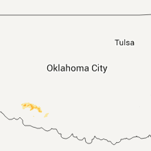
Oklahoma
| Local Time | Report Details |
|---|---|
| 5:35 PM CDT | Half Dollar sized hail reported near Headrick, OK, 60 miles ENE of Childress, TX |
Georgia
| Local Time | Report Details |
|---|---|
| 6:45 PM EDT | The sheriffs office received reports of trees down in and near the brunswick city limits. one tree fell on a home with no reported injuries. the time given was based on in glynn county GA, 56.8 miles N of Jacksonville, FL |
| 7:33 PM EDT | Ksav reported a peak wind gust of 59 mp in chatham county GA, 7.3 miles WNW of Savannah, GA |
| 7:34 PM EDT | Tree down on crossgate rd near hwy 21 in chatham county GA, 7.1 miles NW of Savannah, GA |
| 7:34 PM EDT | Tree fell on a house at 221 byck ave. another tree fell at 241 byck ave pulling down power lines. another tree down near intersection of byck ave and chatham villa dr o in chatham county GA, 4.5 miles WNW of Savannah, GA |
Wyoming
| Local Time | Report Details |
|---|---|
| 6:27 PM MDT | Quarter sized hail reported near Moorcroft, WY, 35.2 miles E of Gillette, WY |
Minnesota
| Local Time | Report Details |
|---|---|
| 7:34 PM CDT | Quarter sized hail reported near Luverne, MN, 27 miles ENE of Sioux Falls, SD |
| 7:54 PM CDT | Golf Ball sized hail reported near Ellsworth, MN, 35.8 miles E of Sioux Falls, SD |
| 3:40 AM CDT | Storm damage reported in rock county MN, 19.2 miles ENE of Sioux Falls, SD |
Nebraska
| Local Time | Report Details |
|---|---|
| 2:15 AM CDT | Storm damage reported in cherry county NE, 0.3 miles S of Valentine, NE |
| 2:16 AM CDT | Storm damage reported in brown county NE, 41.7 miles ESE of Valentine, NE |
| 3:00 AM CDT | Storm damage reported in holt county NE, 0.2 miles NNW of Oneill, NE |
Connect with Interactive Hail Maps