

Hail Map for Saturday, June 22, 2019

Number of Impacted Households on 6/22/2019
0
Impacted by 1" or Larger Hail
0
Impacted by 1.75" or Larger Hail
0
Impacted by 2.5" or Larger Hail
Square Miles of Populated Area Impacted on 6/22/2019
0
Impacted by 1" or Larger Hail
0
Impacted by 1.75" or Larger Hail
0
Impacted by 2.5" or Larger Hail


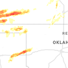


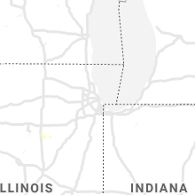


Cities Most Affected by Hail Storms of 6/22/2019
| Hail Size | Demographics of Zip Codes Affected | ||||||
|---|---|---|---|---|---|---|---|
| City | Count | Average | Largest | Pop Density | House Value | Income | Age |
| Hutchinson, KS | 2 | 2.38 | 2.75 | 138 | $46k | $29.0k | 33.5 |
| Wheeler, TX | 2 | 2.00 | 2.00 | 2 | $42k | $32.9k | 35.1 |
| Campo, CO | 1 | 2.00 | 2.00 | 0 | $22k | $24.6k | 51.3 |
| Kim, CO | 1 | 2.00 | 2.00 | 0 | $39k | $31.8k | 52.4 |
| Clarendon, TX | 1 | 2.00 | 2.00 | 1 | $51k | $29.3k | 42.4 |
| Whitmire, SC | 1 | 1.75 | 1.75 | 24 | $41k | $25.4k | 43.5 |
| Two Buttes, CO | 1 | 1.75 | 1.75 | 0 | $35k | $31.6k | 49.5 |
| Harper, KS | 1 | 1.75 | 1.75 | 10 | $47k | $33.3k | 42.2 |
| Johnson, KS | 1 | 1.75 | 1.75 | 1 | $73k | $39.9k | 35.1 |
| Amorita, OK | 1 | 1.58 | 1.58 | 2 | $10k | $25.0k | 48.3 |
Hail and Wind Damage Spotted on 6/22/2019
Filter by Report Type:Hail ReportsWind Reports
States Impacted
Alabama, Missouri, Georgia, South Carolina, Colorado, Mississippi, Kentucky, North Carolina, Tennessee, Kansas, Texas, Oklahoma, Arizona, Iowa, NebraskaAlabama
| Local Time | Report Details |
|---|---|
| 12:59 PM CDT | Trees and a large power line down on sockwell lan in colbert county AL, 10.6 miles SE of Florence, AL |
| 1:00 PM CDT | Trees and power lines down along duncan lane and county line roa in colbert county AL, 11.5 miles SE of Florence, AL |
| 1:01 PM CDT | Half Dollar sized hail reported near Leighton, AL, 10.8 miles SE of Florence, AL, through broadcast media. |
| 1:15 PM CDT | A tree was knocked down on cr 91/lambs ferry roa in lauderdale county AL, 20.9 miles E of Florence, AL |
| 2:23 PM CDT | Trees down near winston and walker county line on hwy 195 per sheriff dispatch. time estimated by rada in winston county AL, 46.1 miles NW of Birmingham, AL |
| 2:45 PM CDT | Tree down near the intersection of hunt rd and river rd. time estimated from rada in walker county AL, 27.5 miles NW of Birmingham, AL |
| 2:50 PM CDT | Tree down on hwy 269 near star drive in rd. time estimated from rada in walker county AL, 29.8 miles WNW of Birmingham, AL |
| 2:56 PM CDT | Several trees down on roland johnson parkwa in cullman county AL, 34.7 miles N of Birmingham, AL |
| 3:05 PM CDT | Quarter sized hail reported near Dora, AL, 21.6 miles NW of Birmingham, AL, received via social media. time estimated from radar. |
| 3:05 PM CDT | Tree down on scenic trail. time estimate in blount county AL, 24.1 miles N of Birmingham, AL |
| 3:08 PM CDT | Several trees blown down near the river along cr 2 in blount county AL, 34.2 miles N of Birmingham, AL |
| 3:10 PM CDT | Trees down within the city. time estimated from rada in blount county AL, 40.6 miles NNE of Birmingham, AL |
| 3:10 PM CDT | Trees down within the city. time estimated from rada in blount county AL, 25.7 miles N of Birmingham, AL |
| 3:10 PM CDT | Tree down near intersection of flat top rd and lacy rd. time estimated from rada in jefferson county AL, 17.5 miles WNW of Birmingham, AL |
| 3:15 PM CDT | Several trees were blown down around corne in jefferson county AL, 20.7 miles NNW of Birmingham, AL |
| 3:25 PM CDT | Tree and power lines down on walker chapel rd. time estimated from rada in jefferson county AL, 6.2 miles N of Birmingham, AL |
| 3:25 PM CDT | Trees down on hwy 26 near camp branch. time estimate in shelby county AL, 21.6 miles S of Birmingham, AL |
| 3:38 PM CDT | A roof of a barn was blown off and several trees were blown down along highway 13 in etowah county AL, 44.2 miles NE of Birmingham, AL |
| 3:40 PM CDT | Trees down in and around the city. time estimate in shelby county AL, 16.3 miles SE of Birmingham, AL |
| 3:42 PM CDT | Trees blown down around altoon in etowah county AL, 45.5 miles NE of Birmingham, AL |
| 3:45 PM CDT | Trees down blocking multiple lanes on hwy 431 near sand mountain pawn. time estimate in etowah county AL, 59.8 miles NE of Birmingham, AL |
| 3:48 PM CDT | Trees uprooted near the forest oaks elementary schoo in shelby county AL, 16.8 miles SE of Birmingham, AL |
| 3:49 PM CDT | Multiple trees were blown down at lawson gap road and mountainboro roa in etowah county AL, 57.1 miles NE of Birmingham, AL |
| 3:50 PM CDT | Multiple trees down in and around town. time estimate in shelby county AL, 19.6 miles SE of Birmingham, AL |
| 3:50 PM CDT | Tree down on hwy 411 near new hopewell baptist church. received via social media. time estimate in st. clair county AL, 45.8 miles NE of Birmingham, AL |
| 3:50 PM CDT | Multiple trees down in and around town. time estimated from rada in shelby county AL, 27.2 miles SE of Birmingham, AL |
| 3:55 PM CDT | Tree on home on alabama avenue. fd en route. time estimate in etowah county AL, 56.7 miles NE of Birmingham, AL |
| 4:00 PM CDT | Trees were blown down at noccalula falls park campgroun in etowah county AL, 57.9 miles NE of Birmingham, AL |
| 4:00 PM CDT | Multiple trees down in and around town. time estimate in shelby county AL, 25.1 miles ESE of Birmingham, AL |
| 4:01 PM CDT | Several trees were blown down around the city of gadsde in etowah county AL, 58.6 miles NE of Birmingham, AL |
| 4:05 PM CDT | Multiple trees down and quarter size hail along judd lane. time estimate in talladega county AL, 35.2 miles SE of Birmingham, AL |
| 4:25 PM CDT | Trees down along lakeshore dr. time estimated from rada in st. clair county AL, 27.9 miles E of Birmingham, AL |
| 4:48 PM CDT | Trees were blown dow in clay county AL, 50.2 miles NNW of Auburn, AL |
| 4:50 PM CDT | Tree down on house on east college st. time estimate in clay county AL, 50.9 miles NNW of Auburn, AL |
| 4:50 PM CDT | Trees were blown dow in tallapoosa county AL, 28.3 miles NNW of Auburn, AL |
| 4:50 PM CDT | Carport collapsed at residence along hwy 77. time estimated from rada in clay county AL, 46.1 miles NNW of Auburn, AL |
| 5:01 PM CDT | Quarter sized hail reported near Northport, AL, 49 miles WSW of Birmingham, AL |
| 5:05 PM CDT | Trees down along cypress creek ave. just north of this location... trees also down along hargrove rd e. time estimated from rada in tuscaloosa county AL, 46.9 miles WSW of Birmingham, AL |
| 5:20 PM CDT | Several trees down in and round the city. time estimated from rada in tallapoosa county AL, 22.3 miles NW of Auburn, AL |
| 5:25 PM CDT | Trees down near intersection of sr 50 and cold creek rd. time estimated from rada in tallapoosa county AL, 23.3 miles WNW of Auburn, AL |
| 5:30 PM CDT | Trees blown down on cr in lamar county AL, 38.3 miles ENE of Starkville, MS |
| 5:37 PM CDT | Trees down along 26th ave. time estimated from rada in chambers county AL, 22.9 miles NE of Auburn, AL |
| 5:38 PM CDT | Tree down on cr 114. time estimated from rada in chambers county AL, 26.6 miles N of Auburn, AL |
| 6:00 PM CDT | A few trees blown dow in elmore county AL, 27.7 miles W of Auburn, AL |
| 8:18 PM CDT | A tree was knocked down at cr 24 and leona driv in lauderdale county AL, 5.5 miles N of Florence, AL |
Missouri
| Local Time | Report Details |
|---|---|
| 1:00 PM CDT | Several roads closed across osage county due to floodin in osage county MO, 47.9 miles SE of Columbia, MO |
| 5:24 PM CDT | Power pole broken at hwy 169 and cr 30 in andrew county MO, 54 miles N of Kansas City, MO |
| 5:28 PM CDT | Storm damage reported in buchanan county MO, 49.2 miles NNW of Kansas City, MO |
| 5:39 PM CDT | Power lines down in east wathena and west elwoo in doniphan county KS, 48.6 miles NNW of Kansas City, MO |
| 6:22 PM CDT | Trees down across the road on highway 1 just past highway a in daviess county MO, 68.8 miles NNE of Kansas City, MO |
| 6:43 PM CDT | Power lines dow in dekalb county MO, 46.9 miles NNE of Kansas City, MO |
| 7:00 PM CDT | Storm damage reported in daviess county MO, 63.5 miles NNE of Kansas City, MO |
| 7:27 PM CDT | Several structures near trenton sustained damage... including several power lines dow in grundy county MO, 84.2 miles NE of Kansas City, MO |
| 7:35 PM CDT | Storm damage reported in grundy county MO, 85.7 miles NNE of Kansas City, MO |
| 10:33 PM CDT | Storm damage reported in cass county MO, 26.7 miles SE of Kansas City, MO |
| 10:45 PM CDT | Wind gusted to 60 mph for at least 30 seconds in creighto in cass county MO, 50.5 miles SSE of Kansas City, MO |
| 10:55 PM CDT | Off duty nws meteorologists. large tree broken and hit side of house. power ou in johnson county MO, 43.2 miles SE of Kansas City, MO |
| 11:04 PM CDT | Storm damage reported in johnson county MO, 51.7 miles ESE of Kansas City, MO |
| 11:09 PM CDT | Corrected for time. storm chaser in warrensburg measured 73 mph win in johnson county MO, 51.7 miles ESE of Kansas City, MO |
| 11:39 PM CDT | Tree damage in sedalia. report via mpin in pettis county MO, 49.9 miles WSW of Columbia, MO |
| 11:50 PM CDT | 15th and engineer ave in sedali in pettis county MO, 50.4 miles WSW of Columbia, MO |
Georgia
| Local Time | Report Details |
|---|---|
| 2:18 PM EDT | A tree was down blocking the road on hwy 278 near the intersection of hwy 8 in emanuel county GA, 64.2 miles S of Augusta, GA |
| 3:35 PM EDT | Quarter sized hail reported near Lithia Springs, GA, 13.8 miles W of Atlanta, GA, quarter-sized hail reported at sweetwater creek state park. |
| 3:54 PM EDT | The county warning point reports a tree down on powerlines on east 4th street. time estimated based on rada in mcintosh county GA, 53.3 miles SSW of Savannah, GA |
| 3:58 PM EDT | The county warning point reports a tree down on lakeview roa in bulloch county GA, 49.2 miles NW of Savannah, GA |
| 4:06 PM EDT | A tree was reported down by the screven 911 center on rocky ford rd and thomasboro rd. time estimated by rada in screven county GA, 53.5 miles SSE of Augusta, GA |
| 4:08 PM EDT | Tree and power lines reported down on still l in wheeler county GA, 46.8 miles NNE of Douglas, GA |
| 4:09 PM EDT | Tree reported down on a home on campground rd near the intersection with us- in jefferson county GA, 24.1 miles SW of Augusta, GA |
| 4:10 PM EDT | Tree reported down on cat squirrel lane near glenwoo in wheeler county GA, 46.6 miles NNE of Douglas, GA |
| 4:12 PM EDT | A tree was reported down at buttermilk rd and mcdonald rd. time estimated by rada in screven county GA, 48 miles SSE of Augusta, GA |
| 4:16 PM EDT | Burke county sheriff reported trees and power lines down in the town of waynesbor in burke county GA, 26.9 miles S of Augusta, GA |
| 4:28 PM EDT | 2 to 3 trees down near woodlawn rd and adams rd in newton county GA, 38.9 miles ESE of Atlanta, GA |
| 4:29 PM EDT | Mulitple trees were reported down near hwy 84 and simmons crossing se by the 911 center. time was estimated by rada in long county GA, 42.3 miles WSW of Savannah, GA |
| 4:36 PM EDT | Corrects previous tstm wnd gst report from 5 nne waynesboro. skywarn spotter reported estimated winds of 58 mph... no hail... extremely heavy rain in burke county GA, 22 miles S of Augusta, GA |
| 4:54 PM EDT | Tree on a power line on rye patch r in long county GA, 42.7 miles WSW of Savannah, GA |
| 4:55 PM EDT | Tree down on a mobile home on n macon st in ludowici. injuries unknow in long county GA, 46 miles WSW of Savannah, GA |
| 4:57 PM EDT | Sheriff dept reported numerous treed down near the county lin in lincoln county GA, 31.4 miles WNW of Augusta, GA |
| 4:57 PM EDT | Sheriff dept reported numerous trees down along lincolnton highway and north fish dam roa in mcduffie county GA, 30.4 miles WNW of Augusta, GA |
| 5:13 PM EDT | Tree down across the road at the intersection of hwy 142 and georgia 1 in putnam county GA, 60.6 miles ESE of Atlanta, GA |
| 5:27 PM EDT | Tree reported down in the road at the intersection of hwy 16 and old augusta r in hancock county GA, 58.6 miles WSW of Augusta, GA |
| 5:30 PM EDT | Tree reported down in the road at the intersection of hwy 15 and cody johnson r in hancock county GA, 58.2 miles WSW of Augusta, GA |
| 5:56 PM EDT | Power line reported down across sgoda r in twiggs county GA, 85.9 miles SE of Atlanta, GA |
| 6:15 PM EDT | Several trees downed and small shelters damaged 10 miles south of surrenc in appling county GA, 38.7 miles E of Douglas, GA |
| 6:25 PM EDT | Reports of a tree down near clem community cente in carroll county GA, 40.8 miles WSW of Atlanta, GA |
| 6:40 PM EDT | A few trees down on ga hwy 219 between bartley rd and baughs cross rd in troup county GA, 34.9 miles NE of Auburn, AL |
| 6:48 PM EDT | Power line down along the 1200 block of country club road north of newna in coweta county GA, 32.6 miles SW of Atlanta, GA |
| 7:06 PM EDT | Recieved photos of tree damage near huddleston pon in fayette county GA, 25.9 miles SSW of Atlanta, GA |
| 7:08 PM EDT | Large tree blocking 3/4 of the road near georgia pacifi in meriwether county GA, 45.9 miles ENE of Auburn, AL |
| 7:10 PM EDT | Few trees down in fd roosevelt state park in harris county GA, 41.5 miles ENE of Auburn, AL |
| 7:42 PM EDT | Reports of wind damage to powerlines along lifsey springs rd in pike county GA, 49.5 miles S of Atlanta, GA |
| 7:50 PM EDT | Ping Pong Ball sized hail reported near Byron, GA, 78.8 miles SSE of Atlanta, GA, spotter reported hail approximately the size of ping pong balls just nw of byron. |
| 8:18 PM EDT | Reports of wires down and blocked roadway at jordan rd sw and old tucker rd sw. due to significant weather advisor in gwinnett county GA, 16.1 miles ENE of Atlanta, GA |
| 9:23 PM EDT | Tree blocking roadway on ball ground hw in cherokee county GA, 38.7 miles N of Atlanta, GA |
| 9:30 PM EDT | Trees down across elliot family parkway se of emm in dawson county GA, 51.1 miles NNE of Atlanta, GA |
| 9:35 PM EDT | Utility line down near the 1700 block of hood rd ne of jasper g in pickens county GA, 51.2 miles N of Atlanta, GA |
| 10:48 PM EDT | Trees down on the 100 block of brittany drive se of perry g in houston county GA, 81.5 miles NW of Douglas, GA |
South Carolina
| Local Time | Report Details |
|---|---|
| 2:40 PM EDT | Quarter sized hail reported near Cleveland, SC, 16.4 miles NNW of Greenville, SC, up to 1 inch hail se of caesars head state park. |
| 3:00 PM EDT | Public reported several trees down on ridge springs r in pickens county SC, 15.4 miles N of Greenville, SC |
| 3:29 PM EDT | Schp reported a tree down near intersection of gano dr. and silver lake rd. time estimated by rada in spartanburg county SC, 28.6 miles E of Greenville, SC |
| 3:29 PM EDT | Schp reported a tree down near the intersection of rogers bridge rd and main st. time estimated by rada in spartanburg county SC, 28.9 miles E of Greenville, SC |
| 3:36 PM EDT | Trees down nw of spartanburg... s in spartanburg county SC, 38.2 miles ENE of Greenville, SC |
| 3:54 PM EDT | Half Dollar sized hail reported near Moore, SC, 34.7 miles E of Greenville, SC, up to half dollar-sized hail sw of roebuck... sc. |
| 4:05 PM EDT | Numerous trees and some power lines down... mainly between jonesville and unio in union county SC, 56.3 miles E of Greenville, SC |
| 4:19 PM EDT | The 911 center reported a tree that had fallen onto a vehicle near savannah hwy and browning gate rd. time is estimated by rada in hampton county SC, 46.5 miles N of Savannah, GA |
| 4:22 PM EDT | Schp reported a tree down near the intersection of highway 601 and highway 3. time estimated from radar dat in hampton county SC, 45.7 miles N of Savannah, GA |
| 4:24 PM EDT | Schp reported a tree down near highway 321. time estimated from radar dat in hampton county SC, 43.6 miles NNW of Savannah, GA |
| 4:38 PM EDT | Golf Ball sized hail reported near Whitmire, SC, 60.8 miles ESE of Greenville, SC, golf ball size hail reported in whitmire. time estimated by radar. |
| 4:46 PM EDT | Schp reported a tree down. time estimated from radar dat in jasper county SC, 36.3 miles NNE of Savannah, GA |
| 4:46 PM EDT | Schp reported trees down near the intersection of pocotaligo road and early branch... abe trail and highway 3... and two sisters ferry road and mount carmel road. time in hampton county SC, 48.9 miles N of Savannah, GA |
| 4:49 PM EDT | A 911 center reported a tree down on castle hall rd and hwy 17. time is estimated by rada in beaufort county SC, 41 miles NNE of Savannah, GA |
| 4:57 PM EDT | A tree was reported down by the beaufort county 911 center on wimbee landing road and kinloch rd. time is estimated by rada in beaufort county SC, 41.1 miles NE of Savannah, GA |
| 4:58 PM EDT | Schp reported tree in roadway i-77 at sc-200. time estimated by rada in fairfield county SC, 50 miles S of Charlotte, NC |
| 5:02 PM EDT | Schp reported a tree down near the intersection of lowcountry highway and hendersonville highway. time estimated from report and from radar dat in colleton county SC, 46.6 miles NNE of Savannah, GA |
| 5:05 PM EDT | Schp reported tree in roadway reservoir road. time estimated by rada in fairfield county SC, 62.3 miles SSW of Charlotte, NC |
| 5:07 PM EDT | A tree was reported down on river road by a 911 center. time is estimated by rada in beaufort county SC, 45.4 miles NNE of Savannah, GA |
| 5:09 PM EDT | A tree was reported down at river road and charleston hwy by the beaufort county 911 center. time is estimated by rada in beaufort county SC, 44.5 miles NNE of Savannah, GA |
| 5:14 PM EDT | A tree was reported down by the beaufort county 911 center at jenkins rd and charleston hwy. time is estimated by rada in beaufort county SC, 43.3 miles NNE of Savannah, GA |
| 5:19 PM EDT | Schp reported a tree down near the intersection of hendersonville highway and ritter road. time estimated from radar dat in colleton county SC, 50 miles SW of Charleston, SC |
| 5:19 PM EDT | Allendale county dispatch reported a tree down on cow pen branch r in allendale county SC, 58.7 miles ESE of Augusta, GA |
| 5:22 PM EDT | The 911 center reported wires down on boundary street and wilmington street. time is estimated by rada in beaufort county SC, 38 miles NE of Savannah, GA |
| 5:24 PM EDT | Corrects previous tstm wnd dmg report from 3 nne chesterfield. trees reported down on hwy 145 and sweeney rd. corrected time estimated by rada in chesterfield county SC, 53.2 miles SE of Charlotte, NC |
| 5:25 PM EDT | The 911 center reported wires down on sams point rd. time is estimated by rada in beaufort county SC, 34.5 miles NE of Savannah, GA |
| 5:27 PM EDT | Tree down on turkey farm road. time estimated by rada in richland county SC, 73.6 miles NE of Augusta, GA |
| 5:31 PM EDT | Trees reported down on hwy 145 and sweeney rd. time estimated by rada in chesterfield county SC, 53.2 miles SE of Charlotte, NC |
| 5:32 PM EDT | Schp reported multiple trees down on boston st... rhea st and darby st. time estimated by rada in richland county SC, 67.5 miles NE of Augusta, GA |
| 5:35 PM EDT | Schp reported tree in roadway i-20 at mm 74eb. time estimated by rada in richland county SC, 69.4 miles NE of Augusta, GA |
| 5:38 PM EDT | Sc law enforcement report trees in roadway near wallace... sc. time estimated via rada in marlboro county SC, 65.3 miles ESE of Charlotte, NC |
| 5:40 PM EDT | Trees and power lines down near the intersection of parklane road and hwy 277. time estimated from rada in richland county SC, 72 miles NE of Augusta, GA |
| 5:49 PM EDT | Sc state troopers reported downed trees along sc-79 just north of bennettsvill in marlboro county SC, 72.8 miles ESE of Charlotte, NC |
| 5:51 PM EDT | Public reported large trees down across the road near wallace... s in marlboro county SC, 70.3 miles ESE of Charlotte, NC |
| 5:54 PM EDT | Highway patrol reported trees down along i-20 near mile marker 7 in richland county SC, 77.4 miles S of Charlotte, NC |
| 5:55 PM EDT | Highway patrol reported trees down on highway 521 at lockhart roa in kershaw county SC, 63 miles SSE of Charlotte, NC |
| 5:58 PM EDT | Sc law enforcement report trees in the roadway near bennettsville. time estaimted via rada in marlboro county SC, 80.6 miles ESE of Charlotte, NC |
| 6:00 PM EDT | Schp reported tree down on spring hill road. time estimated by rada in sumter county SC, 70.7 miles NNW of Charleston, SC |
| 6:02 PM EDT | Schp reported tree in roadway on hwy 378 near the wateree river swamp. time estimated by rada in sumter county SC, 61.7 miles NNW of Charleston, SC |
| 6:03 PM EDT | News outlet reports that a large tree was blown down (uprooted) in the community of clio narrowly missing a home and a vehicle. the tree was hardwood oak and was estima in marlboro county SC, 86 miles ESE of Charlotte, NC |
| 6:08 PM EDT | Schp reported tree in roadway on catchall road. time estimated by rada in sumter county SC, 64.4 miles NNW of Charleston, SC |
| 6:10 PM EDT | Schp reported tree down on black river road. time estimated by rada in sumter county SC, 63.8 miles NNW of Charleston, SC |
| 6:12 PM EDT | Schp reported tree down on loring mill rd and hwy 378. time estimated by rada in sumter county SC, 57.9 miles NNW of Charleston, SC |
| 6:15 PM EDT | Schp reports a tree down on sears st at memorial blv in dorchester county SC, 32.9 miles W of Charleston, SC |
| 6:15 PM EDT | Highway patrol reported trees down on i-26 near mile marker 13 in calhoun county SC, 60.7 miles ENE of Augusta, GA |
| 6:20 PM EDT | Trees reported down on old manning roa in sumter county SC, 46.7 miles NNW of Charleston, SC |
| 6:20 PM EDT | Schp reported multiple trees down on underwood rd... eddie lane and poole rd. time estimated by rada in sumter county SC, 46.3 miles NNW of Charleston, SC |
| 6:21 PM EDT | Sc law enforcement reported a large tree blocking i-95 near dillon... sc. public reported other trees down within the same area of dillo in dillon county SC, 84.7 miles W of Wilmington, NC |
| 6:26 PM EDT | Beaufort county dispatch reported a tree down on family ln near lands end r in beaufort county SC, 35.1 miles ENE of Savannah, GA |
| 6:27 PM EDT | Corrects previous tstm wnd dmg report from 2 wnw shiloh. schp reported tree down on i-95 at mm 138. time estimated by rada in sumter county SC, 52 miles N of Charleston, SC |
| 6:27 PM EDT | Folly pier wxflow gusted to 53 kt at 627 pm. peak gust 56 kt at 632 p in amz350 county SC, 37.9 miles S of Charleston, SC |
| 6:28 PM EDT | Schp reported a tree down on i26 at mm 178e in dorchester county SC, 18.2 miles WSW of Charleston, SC |
| 6:35 PM EDT | Schp reported tree down on i-26 at mm 138. time estimated by rada in sumter county SC, 52 miles N of Charleston, SC |
| 6:41 PM EDT | Sheriff dept reported trees and power lines down county-wide. time estimated by rada in clarendon county SC, 37.2 miles NW of Charleston, SC |
| 6:41 PM EDT | Public reported trees down within the town of mullins on highway 7 in marion county SC, 75.8 miles W of Wilmington, NC |
| 6:42 PM EDT | Public reported several trees down with power outages near the community of clausse in florence county SC, 69.1 miles NNE of Charleston, SC |
| 6:42 PM EDT | Schp reported a tree down on fort johnson r in charleston county SC, 32 miles S of Charleston, SC |
| 6:47 PM EDT | A tree was reported down on mudville rd by the berkeley county 911 center. time is estimated by rada in berkeley county SC, 12.1 miles W of Charleston, SC |
| 7:00 PM EDT | Sheriff dept reported trees and power lines down county-wide. time estimated by rada in clarendon county SC, 38.8 miles N of Charleston, SC |
| 7:12 PM EDT | Public reported large trees downed near magnolia highway east of aynor... s in horry county SC, 69.9 miles WSW of Wilmington, NC |
| 7:15 PM EDT | Several trees down near galivants ferry... sc. report corroborated by sc law enforcement mentioning trees down on pee dee highwa in horry county SC, 72.5 miles NE of Charleston, SC |
| 7:29 PM EDT | Public reported trees down near the town of aynor. sc law enforecement also report trees down along sc31 in horry county SC, 70.9 miles WSW of Wilmington, NC |
| 7:47 PM EDT | Public reported several trees down near the town of georgetown. a few of these trees were found blocking roadway in georgetown county SC, 34.1 miles E of Charleston, SC |
| 7:53 PM EDT | Multiple power lines down near little river... sc blocking an intersection on us-17. time estimated via rada in horry county SC, 46.1 miles WSW of Wilmington, NC |
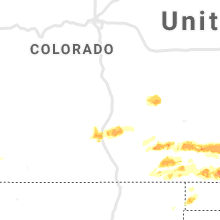
Colorado
| Local Time | Report Details |
|---|---|
| 1:55 PM MDT | Quarter sized hail reported near Cimarron, CO, 69.4 miles SE of Grand Junction, CO, lasted 10 minutes. |
| 7:28 PM MDT | Hen Egg sized hail reported near Kim, CO, 80.8 miles ESE of Pueblo, CO |
| 9:17 PM MDT | Corrects previous tstm wnd gst report from 9 s springfield. asos station ksp in baca county CO, 107 miles WSW of Garden City, KS |
| 9:25 PM MDT | Golf Ball sized hail reported near Two Buttes, CO, 88.2 miles WSW of Garden City, KS |
| 9:56 PM MDT | Quarter sized hail reported near Campo, CO, 110.9 miles WSW of Garden City, KS, corrects previous hail report from 1 n campo. |
| 9:58 PM MDT | Hen Egg sized hail reported near Campo, CO, 109.8 miles WSW of Garden City, KS |
Mississippi
| Local Time | Report Details |
|---|---|
| 3:12 PM CDT | Large tree down on cr 117 in lee county MS, 56 miles NNE of Starkville, MS |
| 3:35 PM CDT | Tree down across dorsey evergreen r in itawamba county MS, 56.3 miles NNE of Starkville, MS |
Kentucky
| Local Time | Report Details |
|---|---|
| 3:24 PM CDT | Siding peeled back from a house. time estimate in christian county KY, 50.6 miles NW of Nashville, TN |
North Carolina
| Local Time | Report Details |
|---|---|
| 4:26 PM EDT | Trees down near selwyn and queens av in mecklenburg county NC, 2.9 miles S of Charlotte, NC |
| 4:30 PM EDT | Social media report of a large tree down at lawyers rd & lebanon r in mecklenburg county NC, 8.6 miles ESE of Charlotte, NC |
| 4:38 PM EDT | Multiple trees down off hwy 601 just north of monroe... n in union county NC, 22.8 miles SE of Charlotte, NC |
| 4:59 PM EDT | Trees down on savannah rd. power lines also reported down at lower white store rd and mineral springs church rd on the south side of peachlan in anson county NC, 35 miles ESE of Charlotte, NC |
| 5:10 PM EDT | Trees down on nc 742 n in wadesbor in anson county NC, 43.4 miles ESE of Charlotte, NC |
| 5:15 PM EDT | Trees down at us highway 52 and country club rd in wadesbor in anson county NC, 47.9 miles ESE of Charlotte, NC |
| 5:15 PM EDT | Numerous trees down across anson county. time and location approximate pending more detailed informatio in anson county NC, 45.5 miles ESE of Charlotte, NC |
| 5:31 PM EDT | Tree reported down on hwy 52. time estimated by rada in chesterfield county SC, 56.8 miles ESE of Charlotte, NC |
| 5:33 PM EDT | Trees and power poles down at us 1 south and st stephens church r in richmond county NC, 60.9 miles ESE of Charlotte, NC |
| 5:43 PM EDT | Trees down at aslington st and hamer rd in rockingha in richmond county NC, 63.3 miles ESE of Charlotte, NC |
| 5:48 PM EDT | Tree and power lines down on 4th st in hamle in richmond county NC, 69.2 miles ESE of Charlotte, NC |
| 5:56 PM EDT | Multiple trees and power lines down on old wire rd... rockingham rd... and old stage rd... to the west and south of laurel hil in scotland county NC, 76.8 miles ESE of Charlotte, NC |
| 6:41 PM EDT | Public reported large trees down near the town of fairmont with damage to power lines. duke energy also shows widespread power outages in the area. time estimated via r in robeson county NC, 68.8 miles WNW of Wilmington, NC |
| 7:53 PM EDT | Columbus county 911 call center reports multiple trees down with power outages in the town of nikina and surrounding areas. time estimated via rada in columbus county NC, 42.1 miles W of Wilmington, NC |
| 8:03 PM EDT | Public reported large trees down and power outages near the town of ash... nc just after 8pm. time estimated via rada in brunswick county NC, 35 miles WSW of Wilmington, NC |
Tennessee
| Local Time | Report Details |
|---|---|
| 3:28 PM CDT | Several trees down and roof damage to homes in the hazelwood subdivision in montgomery county TN, 43.8 miles NW of Nashville, TN |
| 3:32 PM CDT | Several trees and power lines down across the city of clarksville in montgomery county TN, 41.8 miles NW of Nashville, TN |
| 3:34 PM CDT | Trees down blocking whitfield road and warfield blvd in montgomery county TN, 41.8 miles NW of Nashville, TN |
| 3:37 PM CDT | Several trees down at beachaven winery at i-24 and dunlop road in montgomery county TN, 39.1 miles NW of Nashville, TN |
| 3:45 PM CDT | Tree blown down on a ca in montgomery county TN, 35.8 miles NW of Nashville, TN |
| 3:45 PM CDT | Photo showed tree fell onto a house in sango in montgomery county TN, 33.2 miles NW of Nashville, TN |
| 3:54 PM CDT | Trees reportedly blown down onto i-24 in montgomery county TN, 28.6 miles NW of Nashville, TN |
| 4:12 PM CDT | Spotter estimates 60 mph wind gus in robertson county TN, 19.6 miles NNW of Nashville, TN |
| 4:12 PM CDT | Photo showed tree down across road at 1646 ridge circle in joelton in cheatham county TN, 17.2 miles NW of Nashville, TN |
| 4:34 PM CDT | Trees down blocking whitfield road and warfield blvd in montgomery county TN, 41.8 miles NW of Nashville, TN |
| 4:43 PM CDT | Large tree limbs down in oak hill area in davidson county TN, 4 miles S of Nashville, TN |
| 4:50 PM CDT | Tree down on power line on chandler road in hermitage in davidson county TN, 9.5 miles E of Nashville, TN |
| 4:51 PM CDT | 3 trees down on highway 368. time is radar estimate in hardeman county TN, 49 miles E of Memphis, TN |
| 4:52 PM CDT | Large tree limbs down in mount juliet on old lebanon dirt road in wilson county TN, 15.1 miles E of Nashville, TN |
| 5:00 PM CDT | Numerous large trees down on gore road at highway 64 in lawrence county TN, 36.3 miles NNE of Florence, AL |
| 5:25 PM CDT | Tree and power line down across highway 242 with roadway blocked in westpoint in lawrence county TN, 24.2 miles NNE of Florence, AL |
| 6:23 PM CDT | County sheriff reports trees down in the county. also... mping report indicates trees down and uprooted and a roof blown off of structure. but report did not specify fr in franklin county TN, 44.6 miles WNW of Chattanooga, TN |
| 6:32 PM CDT | Tree down across a road near kimbal in marion county TN, 20.4 miles W of Chattanooga, TN |
| 6:35 PM CDT | 7 reports of trees down near south pittsburg and new hope across the south end of the count in marion county TN, 21.1 miles W of Chattanooga, TN |
| 6:45 PM CDT | Tree down in gillis mills cemeter in hardin county TN, 29.6 miles NW of Florence, AL |
Kansas
| Local Time | Report Details |
|---|---|
| 4:09 PM CDT | Quarter sized hail reported near Ellsworth, KS, 64.5 miles E of Hays, KS |
| 4:12 PM CDT | Half Dollar sized hail reported near Ellsworth, KS, 60.2 miles E of Hays, KS |
| 4:45 PM CDT | Quarter sized hail reported near Topeka, KS, 42 miles E of Manhattan, KS |
| 5:00 PM CDT | 1 to 2 inch tree limbs down. delayed repor in jefferson county KS, 48.4 miles W of Kansas City, MO |
| 5:15 PM CDT | Wind gusts are at least 60 mph... estimated in excess of 60 mp in jefferson county KS, 48.4 miles W of Kansas City, MO |
| 5:23 PM CDT | Golf Ball sized hail reported near Harper, KS, 46.3 miles WSW of Wichita, KS |
| 5:35 PM CDT | 60- 70 mph wind gusts on us 59 at rogers roa in jefferson county KS, 43.7 miles WNW of Kansas City, MO |
| 5:59 PM CDT | 60-65 mph estimate in harper county KS, 47 miles SW of Wichita, KS |
| 6:02 PM CDT | Quarter sized hail reported near Beloit, KS, 77.2 miles ENE of Hays, KS, report via social media. |
| 6:05 PM CDT | Part of a live and healthy 12 inch tree fell onto a house just northeast of lansing. winds were around 50 mph at the time per emergency managemen in leavenworth county KS, 20.1 miles NW of Kansas City, MO |
| 6:10 PM CDT | Estimated 60 to 70 mph west of goddard. blowing dust as wel in sedgwick county KS, 17.3 miles W of Wichita, KS |
| 6:23 PM CDT | Hen Egg sized hail reported near Hutchinson, KS, 39.4 miles NW of Wichita, KS |
| 6:24 PM CDT | Delayed repor in jackson county KS, 39.8 miles ENE of Manhattan, KS |
| 6:25 PM CDT | 8 foot section of fence blown down in sedgwick county KS, 13.5 miles W of Wichita, KS |
| 6:26 PM CDT | Baseball sized hail reported near Hutchinson, KS, 36.6 miles NW of Wichita, KS, tennis ball to baseball sized reported |
| 6:27 PM CDT | Estimated 75 to 80 mph winds in goddar in sedgwick county KS, 13.5 miles W of Wichita, KS |
| 6:34 PM CDT | Media chaser reports 65-70 mph winds at the dillon warehous in sedgwick county KS, 13.5 miles W of Wichita, KS |
| 6:34 PM CDT | Storm damage reported in sedgwick county KS, 22.4 miles SW of Wichita, KS |
| 6:43 PM CDT | Storm damage reported in sedgwick county KS, 6.8 miles W of Wichita, KS |
| 6:43 PM CDT | Winds estimated greater than 60 mph in mcpherson county KS, 50.3 miles NNW of Wichita, KS |
| 6:45 PM CDT | 60-65 mph winds at maize and kellog in sedgwick county KS, 7.9 miles W of Wichita, KS |
| 6:46 PM CDT | Estimated 65-70 mph winds in west wichita in sedgwick county KS, 6.8 miles W of Wichita, KS |
| 6:46 PM CDT | Quarter sized hail reported near Goddard, KS, 12.2 miles WSW of Wichita, KS, along macarthur road. |
| 6:52 PM CDT | Storm damage reported in riley county KS, 5.9 miles NW of Manhattan, KS |
| 6:53 PM CDT | Storm damage reported in sedgwick county KS, 6.4 miles WNW of Wichita, KS |
| 6:53 PM CDT | Nws employee reported the gus in sedgwick county KS, 8.2 miles WNW of Wichita, KS |
| 6:58 PM CDT | Pea size hail also reporte in sedgwick county KS, 6 miles WSW of Wichita, KS |
| 7:02 PM CDT | 24 inch tree laying across the road near 21st and ridge. numerous reports of tree damage are being reported across west wichita in sedgwick county KS, 6.8 miles W of Wichita, KS |
| 7:12 PM CDT | Large tree limbs down on zoo blv in sedgwick county KS, 7.2 miles WNW of Wichita, KS |
| 7:15 PM CDT | Storm damage reported in sedgwick county KS, 6.2 miles NE of Wichita, KS |
| 7:15 PM CDT | Tree limbs down on a power line at mansfield and gilbert. report via twitte in sedgwick county KS, 5.3 miles E of Wichita, KS |
| 7:22 PM CDT | Storm damage reported in pottawatomie county KS, 17.5 miles NE of Manhattan, KS |
| 8:12 PM CDT | Storm damage reported in sedgwick county KS, 14 miles SSW of Wichita, KS |
| 8:39 PM CDT | 50 mph sustained with gusts to 75 mp in butler county KS, 13.9 miles SE of Wichita, KS |
| 8:56 PM CDT | Storm damage reported in douglas county KS, 37.6 miles WSW of Kansas City, MO |
| 9:09 PM CDT | Estimated 60 mph between beaumont and leon in butler county KS, 38.2 miles E of Wichita, KS |
| 9:11 PM CDT | Microburst caused damage along tank ave between 4th and 8th streets. trees uprooted and power poles snapped of in wilson county KS, 22 miles SW of Chanute, KS |
| 10:00 PM CDT | Delayed report. 12 inch tree uprooted at 311th and beaver creek road. time estimated by radar. estimate on wind speed not give in miami county KS, 38.5 miles SSW of Kansas City, MO |
| 11:29 PM CDT | Storm damage reported in stanton county KS, 55.3 miles WSW of Garden City, KS |
| 11:30 PM CDT | Golf Ball sized hail reported near Johnson, KS, 47.2 miles WSW of Garden City, KS, public report of golf ball size hail northwest of big bow. |
| 11:35 PM CDT | Storm damage reported in stanton county KS, 54.1 miles WSW of Garden City, KS |
| 12:00 AM CDT | Quarter sized hail reported near Ulysses, KS, 37.8 miles SW of Garden City, KS, emergency manager report of quarter size hail in ulysses. |
| 1:10 AM CDT | Ping Pong Ball sized hail reported near Montezuma, KS, 34.8 miles SE of Garden City, KS |
| 1:11 AM CDT | Storm damage reported in gray county KS, 34.8 miles SE of Garden City, KS |
| 1:29 AM CDT | Quarter sized hail reported near Ensign, KS, 41.5 miles ESE of Garden City, KS |
| 1:29 AM CDT | Storm damage reported in gray county KS, 41.5 miles ESE of Garden City, KS |
| 3:20 AM CDT | Storm damage reported in geary county KS, 12.7 miles SW of Manhattan, KS |
| 4:28 AM CDT | Storm damage reported in sumner county KS, 34.7 miles SSW of Wichita, KS |
| 4:55 AM CDT | Power lines and poles down in the peck are in sumner county KS, 15.9 miles S of Wichita, KS |
| 5:08 AM CDT | Numerous reports of trees and power poles down in derby. debris is covering the roadways in spots. time estimated based on rada in sedgwick county KS, 10.3 miles SSE of Wichita, KS |
| 5:09 AM CDT | Wunderground ambient weather station measured 76mph sustained speed with gust to 111mp in sedgwick county KS, 9.5 miles SSE of Wichita, KS |
| 5:09 AM CDT | Wunderground davis weather station measured 67mph gust in sedgwick county KS, 10.5 miles SSE of Wichita, KS |
| 5:10 AM CDT | Storm damage reported in sumner county KS, 25 miles SSE of Wichita, KS |
| 5:14 AM CDT | Tree branches 3-4 inches in diameter down on the northern end of rose hill in butler county KS, 13.9 miles SE of Wichita, KS |
| 5:23 AM CDT | Large tree down across the road on 8 in sedgwick county KS, 15.2 miles SSE of Wichita, KS |
| 6:26 AM CDT | 50 to 60 mph wind in greenwood county KS, 46.9 miles WNW of Chanute, KS |
| 6:51 AM CDT | Storm damage reported in montgomery county KS, 35.2 miles SSW of Chanute, KS |
Texas
| Local Time | Report Details |
|---|---|
| 4:22 PM CDT | A few trees uprooted by the roots just south of tom bea in grayson county TX, 53.6 miles NNE of Dallas, TX |
| 11:50 PM CDT | Baseball sized hail reported near , , 54.5 miles E of Amarillo, TX |
| 11:58 PM CDT | Quarter sized hail reported near Mclean, TX, 59.5 miles NNW of Childress, TX |
| 12:00 AM CDT | Half Dollar sized hail reported near Mclean, TX, 59.5 miles NNW of Childress, TX |
| 12:03 AM CDT | Hen Egg sized hail reported near Clarendon, TX, 54.6 miles E of Amarillo, TX |
| 1:21 AM CDT | Hen Egg sized hail reported near Wheeler, TX, 69.2 miles N of Childress, TX, trained spotter reported hail larger than golf ball... but not quite the size of tennis ball. storm started out as quarters and increased in sized over time. |
| 1:34 AM CDT | Hen Egg sized hail reported near Wheeler, TX, 69.2 miles N of Childress, TX, 2 inch hail stopped after about 10 to 15 minutes of large hail. |
Oklahoma
| Local Time | Report Details |
|---|---|
| 5:15 PM CDT | Ping Pong Ball sized hail reported near Amorita, OK, 70.1 miles ENE of Woodward, OK, time of hail fall estimated. measured with caliper. |
| 2:10 AM CDT | Quarter sized hail reported near Cheyenne, OK, 61.4 miles SSW of Woodward, OK |
Arizona
| Local Time | Report Details |
|---|---|
| 3:35 PM MST | Asos station kinw winslow airport - gust front from decaying storm in navajo county AZ, 54 miles ESE of Flagstaff, AZ |
Iowa
| Local Time | Report Details |
|---|---|
| 7:05 PM CDT | Dime sized hail along with the 60 mph wind in union county IA, 60.2 miles SW of Des Moines, IA |
| 7:15 PM CDT | Quarter sized hail reported near Cromwell, IA, 58 miles SW of Des Moines, IA, hail lasted about 5 minutes - largest stones the size of quarters. |
| 7:50 PM CDT | Pea sized hail as wel in adair county IA, 47.9 miles WSW of Des Moines, IA |
Nebraska
| Local Time | Report Details |
|---|---|
| 8:28 PM CDT | Storm damage reported in richardson county NE, 81.5 miles NE of Manhattan, KS |
Connect with Interactive Hail Maps