

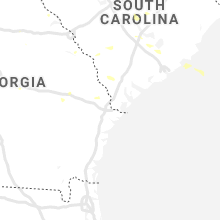
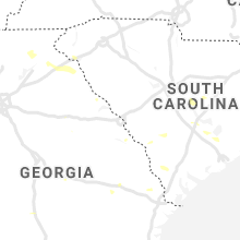
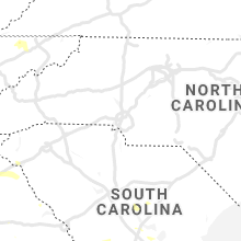
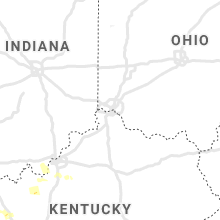
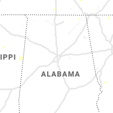
Hail Map for Friday, June 21, 2019

Number of Impacted Households on 6/21/2019
0
Impacted by 1" or Larger Hail
0
Impacted by 1.75" or Larger Hail
0
Impacted by 2.5" or Larger Hail
Square Miles of Populated Area Impacted on 6/21/2019
0
Impacted by 1" or Larger Hail
0
Impacted by 1.75" or Larger Hail
0
Impacted by 2.5" or Larger Hail


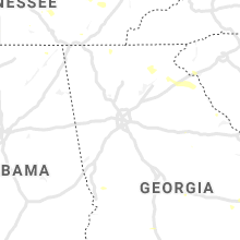
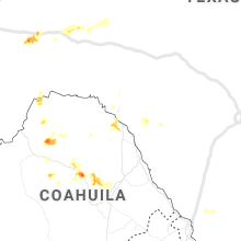


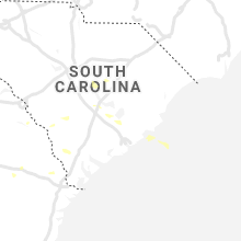


Cities Most Affected by Hail Storms of 6/21/2019
| Hail Size | Demographics of Zip Codes Affected | ||||||
|---|---|---|---|---|---|---|---|
| City | Count | Average | Largest | Pop Density | House Value | Income | Age |
| Matheson, CO | 3 | 2.10 | 2.75 | 1 | $75k | $37.2k | 51.0 |
| Simla, CO | 2 | 1.88 | 2.00 | 3 | $86k | $32.2k | 39.0 |
| Sharon Springs, KS | 2 | 1.75 | 1.75 | 1 | $47k | $34.4k | 46.0 |
| Barlow, KY | 1 | 3.00 | 3.00 | 22 | $46k | $29.4k | 40.5 |
| Monument, KS | 1 | 2.50 | 2.50 | 1 | $47k | $48.0k | 40.5 |
| Claflin, KS | 1 | 2.50 | 2.50 | 4 | $51k | $32.0k | 45.8 |
| Limon, CO | 1 | 2.00 | 2.00 | 2 | $88k | $35.1k | 38.2 |
| Benton, KY | 1 | 1.75 | 1.75 | 101 | $83k | $36.0k | 43.9 |
| Justiceburg, TX | 1 | 1.75 | 1.75 | 1 | $350k | $75.5k | 56.7 |
| Blue Springs, MO | 1 | 1.75 | 1.75 | 2100 | $100k | $55.2k | 34.0 |
| Calhan, CO | 1 | 1.75 | 1.75 | 17 | $121k | $42.2k | 39.6 |
Hail and Wind Damage Spotted on 6/21/2019
Filter by Report Type:Hail ReportsWind Reports
States Impacted
Nebraska, Missouri, Kansas, Iowa, Illinois, Indiana, Colorado, Kentucky, Texas, Tennessee, Alabama, Georgia, North Carolina, South CarolinaNebraska
| Local Time | Report Details |
|---|---|
| 7:02 AM CDT | Tree down. time estimated based on rada in gage county NE, 70.6 miles N of Manhattan, KS |
| 7:11 AM CDT | Several large branches dow in johnson county NE, 59.9 miles SSW of Omaha, NE |
| 7:30 AM CDT | Very strong winds with several limbs dow in johnson county NE, 64.8 miles SSW of Omaha, NE |
| 7:30 AM CDT | Numerous limbs down and street signs blown over throughout tecumseh. some minor street flooding as wel in johnson county NE, 62.9 miles SSW of Omaha, NE |
| 7:38 AM CDT | Storm damage reported in otoe county NE, 45.1 miles S of Omaha, NE |
| 8:34 PM CDT | Quarter sized hail reported near Petersburg, NE, 55.2 miles SSE of Oneill, NE, reported at loreto... ne. |
Missouri
| Local Time | Report Details |
|---|---|
| 7:06 AM CDT | Large tree down at wornell and 61st terrance. report received from kcf in jackson county MO, 5.7 miles S of Kansas City, MO |
| 7:20 AM CDT | 1-inch tree limbs down; shingles blown off homes. report received via mpin in clay county MO, 6.7 miles N of Kansas City, MO |
| 7:45 AM CDT | Quarter sized hail reported near Kansas City, MO, 7.8 miles S of Kansas City, MO |
| 7:45 AM CDT | Delayed report: 8 inch tree limb dow in jackson county MO, 18.6 miles ESE of Kansas City, MO |
| 7:51 AM CDT | Storm damage reported in livingston county MO, 72.8 miles NE of Kansas City, MO |
| 7:53 AM CDT | 1 to 2 inch limbs dow in cass county MO, 22.1 miles SSE of Kansas City, MO |
| 7:58 AM CDT | Quarter sized hail reported near Kansas City, MO, 7 miles SSE of Kansas City, MO |
| 8:00 AM CDT | Storm damage reported in linn county MO, 77.6 miles NW of Columbia, MO |
| 8:00 AM CDT | Delayed report: trees approximately 12-15 inches in diameter down in roadway. roofing material blow off of building. all debris blown ese of original directio in jackson county MO, 18.2 miles S of Kansas City, MO |
| 8:10 AM CDT | Number of 12-24 inch limbs dow in linn county MO, 77.6 miles NW of Columbia, MO |
| 8:14 AM CDT | Quarter sized hail reported near Lees Summit, MO, 15.1 miles SE of Kansas City, MO |
| 8:34 AM CDT | Storm damage reported in linn county MO, 61.8 miles NNW of Columbia, MO |
| 9:01 AM CDT | Delayed report: tree down across the road and power line down near s morley and kwix r in randolph county MO, 31.3 miles N of Columbia, MO |
| 9:01 AM CDT | Storm damage reported in randolph county MO, 31.3 miles N of Columbia, MO |
| 9:05 AM CDT | Golf Ball sized hail reported near Blue Springs, MO, 18.6 miles ESE of Kansas City, MO |
| 9:09 AM CDT | Storm damage reported in randolph county MO, 26.9 miles N of Columbia, MO |
| 9:44 AM CDT | Quarter sized hail reported near Rocheport, MO, 12.3 miles W of Columbia, MO, time estimated from radar. |
| 9:59 AM CDT | Trees and powerlines down in mexico. time estimated from rada in audrain county MO, 26.4 miles NE of Columbia, MO |
| 9:59 AM CDT | Two trees down near the intersection of pearson street and washington street in mexico. time estimated from rada in audrain county MO, 29 miles ENE of Columbia, MO |
| 10:03 AM CDT | 6 inch tree knocked over a roadway in s central columbi in boone county MO, 1.6 miles ESE of Columbia, MO |
| 10:12 AM CDT | Power lines down at kendrick mobile home par in monroe county MO, 53.2 miles S of Kahoka, MO |
| 10:12 AM CDT | Trees down in northern frankfor in pike county MO, 65.9 miles NE of Columbia, MO |
| 10:15 AM CDT | Tree down behind hous in jackson county MO, 3.8 miles SSW of Kansas City, MO |
| 10:20 AM CDT | Power line dow in marion county MO, 44 miles SSE of Kahoka, MO |
| 10:20 AM CDT | Trees down across multiple roads in ralls county... including near ilasco. time estimated from rada in ralls county MO, 56.2 miles SSE of Kahoka, MO |
| 10:30 AM CDT | Delayed report. measured 73 mph gust at lx in jackson county MO, 15.1 miles SE of Kansas City, MO |
| 10:31 AM CDT | Storm damage reported in jackson county MO, 15.1 miles SE of Kansas City, MO |
| 10:52 AM CDT | Storm damage reported in lafayette county MO, 47 miles E of Kansas City, MO |
| 11:08 AM CDT | A couple 18 to 24 inch trees uprooted or snapped at the base. three power poles broken. several tree limbs snappe in audrain county MO, 29.1 miles ENE of Columbia, MO |
| 11:30 AM CDT | Reported at 3641 hopewell rd wentzville tree down reported by law enforcemen in st. charles county MO, 35.5 miles WNW of Saint Louis, MO |
| 11:57 AM CDT | Several 3 to 8 inch branches dow in st. charles county MO, 24.4 miles WNW of Saint Louis, MO |
| 12:28 PM CDT | Mesonet station wktm7 wah kon tah raws wind gust reported of 70 mp in cedar county MO, 61.2 miles NW of Springfield, MO |
| 1:38 PM CDT | Large tree limbs downed near crabtree cove camping park. time estimated by rada in cedar county MO, 40.6 miles NW of Springfield, MO |
| 1:50 PM CDT | Corrects previous non-tstm wnd dmg report from 1 ne bolivar to tstm wnd dmg. a tree landed on a house in bolivar on east division street. time estimated from rada in polk county MO, 29 miles NNW of Springfield, MO |
| 2:05 PM CDT | Tree limbs down. estimated 55-60 mph winds. report via social medi in phelps county MO, 19 miles WNW of Salem, MO |
| 2:07 PM CDT | A tree fell and blocked a roadway on 240th road northeast of pleasant hope. time estimated from rada in polk county MO, 20 miles NNE of Springfield, MO |
| 2:21 PM CDT | Several reports of limbs and objects down in/around salem. reports via social media. time estimated by rada in dent county MO, 0.9 miles NNW of Salem, MO |
| 2:40 PM CDT | Quarter sized hail reported near Strafford, MO, 10.4 miles ENE of Springfield, MO, corrects previous hail report from strafford for time. strafford is reporting heavy... consistent quarter sized hail. time based on radar. |
| 2:45 PM CDT | Quarter sized hail reported near Strafford, MO, 10.4 miles ENE of Springfield, MO, strafford is reporting heavy... consistent quarter sized hail. time based on radar. |
| 3:25 PM CDT | Power lines down in west plains. west plains asos reported at 3:19 pm 41 mph gust. time estimate in howell county MO, 64.9 miles SSW of Salem, MO |
| 3:43 PM CDT | *** 1 fatal... 2 inj *** tree fell on boat on the current river in the vicinity of the waymeyer shute national park service river access. driver of the boat was killed in carter county MO, 48.2 miles SSE of Salem, MO |
| 3:45 PM CDT | Large limbs down on north end of m highwa in carter county MO, 47.4 miles SE of Salem, MO |
| 3:50 PM CDT | Tree and limbs down in the goodhope are in douglas county MO, 33.7 miles SE of Springfield, MO |
| 4:05 PM CDT | Powerlines down. broadcast media relaye in bollinger county MO, 29 miles WNW of Cape Girardeau, MO |
| 4:06 PM CDT | Trees snapped and damage to the porch on a house. time estimate in bollinger county MO, 28.6 miles WNW of Cape Girardeau, MO |
| 4:10 PM CDT | Relayed by broadcast media. 2 trees down in scopu in bollinger county MO, 21.7 miles WNW of Cape Girardeau, MO |
| 4:10 PM CDT | Numerous trees and power lines down around the county. time estimate in bollinger county MO, 23.4 miles W of Cape Girardeau, MO |
| 4:17 PM CDT | Bricks stripped from an apartment building. heavy tree damage. time estimate in cape girardeau county MO, 9.2 miles NW of Cape Girardeau, MO |
| 4:25 PM CDT | Windows blown out of restore horizon. windows also blown out of cars. time estimate in cape girardeau county MO, 0.4 miles WSW of Cape Girardeau, MO |
| 4:25 PM CDT | Multiple trees and tree limbs down... siding peeled of in cape girardeau county MO, 12.2 miles WSW of Cape Girardeau, MO |
| 4:25 PM CDT | 60mph wind gust... broken treelimbs and roof shingle damag in cape girardeau county MO, 1.4 miles W of Cape Girardeau, MO |
| 4:29 PM CDT | Storm damage reported in scott county MO, 5.4 miles SSW of Cape Girardeau, MO |
| 4:30 PM CDT | Large tree blocking highway t 1 mile south of route k in butler county MO, 50.6 miles WSW of Cape Girardeau, MO |
| 4:33 PM CDT | Storm damage reported in butler county MO, 56.9 miles SW of Cape Girardeau, MO |
| 4:40 PM CDT | Home with significant shingle damag in cape girardeau county MO, 10.7 miles SW of Cape Girardeau, MO |
| 4:49 PM CDT | Large tree snapped. photo relayed via twitter. time estimate in butler county MO, 59.9 miles SW of Cape Girardeau, MO |
| 4:55 PM CDT | Tree limbs down. 55-60mph estimat in mississippi county MO, 28.1 miles SSE of Cape Girardeau, MO |
| 5:23 PM CDT | Estimated 60-70 mph wind gust in new madrid county MO, 48.5 miles S of Cape Girardeau, MO |
| 5:37 PM CDT | 60 mph wind gust at kennett airpor in dunklin county MO, 74.5 miles N of Memphis, TN |
Kansas
| Local Time | Report Details |
|---|---|
| 7:22 AM CDT | 12-inch tree limb down. time radar estimate in johnson county KS, 18.9 miles SSW of Kansas City, MO |
| 7:25 AM CDT | Large tree down into house. photos received via twitter. time radar estimate in johnson county KS, 14 miles WSW of Kansas City, MO |
| 7:44 AM CDT | Ping Pong Ball sized hail reported near Prairie Village, KS, 6.9 miles SSW of Kansas City, MO |
| 7:52 AM CDT | Estimates gusts from 50-65mp in geary county KS, 17.9 miles WSW of Manhattan, KS |
| 7:55 AM CDT | Esimated 55-60 mph gust in geary county KS, 18.6 miles WSW of Manhattan, KS |
| 8:36 AM CDT | Ping Pong Ball sized hail reported near Lenexa, KS, 12.7 miles SW of Kansas City, MO |
| 9:05 AM CDT | 5 to 6 inch diameter tree down near the intersection of urish and 29th stree in shawnee county KS, 43.6 miles ESE of Manhattan, KS |
| 9:30 AM CDT | Estimated 60 mph wind gust in douglas county KS, 36.6 miles W of Kansas City, MO |
| 9:35 AM CDT | Tree limb damage and power lines down around perry. time estimated from rada in jefferson county KS, 43.4 miles W of Kansas City, MO |
| 9:38 AM CDT | 3-4 inch tree branches dow in douglas county KS, 36.7 miles WSW of Kansas City, MO |
| 9:40 AM CDT | Em reports numerous power lines down from t-storm winds around city of lawrence. time estimated from rada in douglas county KS, 37.7 miles WSW of Kansas City, MO |
| 9:55 AM CDT | Semi overturned due to t-storm wind gusts near mile marker 188 on i-3 in franklin county KS, 46.9 miles SW of Kansas City, MO |
| 10:16 AM CDT | Storm damage reported in johnson county KS, 25.4 miles SW of Kansas City, MO |
| 10:25 AM CDT | Delayed report. tree damage in lero in coffey county KS, 29.1 miles NNW of Chanute, KS |
| 2:09 PM CDT | Delayed report of 15-20 power poles snapped along rock creek roa in franklin county KS, 52.4 miles SW of Kansas City, MO |
| 8:29 PM MDT | Estimate wind over 60 mp in wallace county KS, 59.7 miles SW of Colby, KS |
| 8:29 PM MDT | Corrects previous tstm wnd gst report from 6 ese weskan. estimate wind over 60 mp in wallace county KS, 59.7 miles SW of Colby, KS |
| 8:30 PM MDT | Ping Pong Ball sized hail reported near Sharon Springs, KS, 51.1 miles SW of Colby, KS |
| 8:32 PM MDT | Golf Ball sized hail reported near Sharon Springs, KS, 51.1 miles SW of Colby, KS, report received via social media. |
| 8:32 PM MDT | Report received via social medi in wallace county KS, 51.1 miles SW of Colby, KS |
| 8:32 PM MDT | Tree fell on a truck. est golf ball size hail and 80 plus mph wind gust in wallace county KS, 51.6 miles SW of Colby, KS |
| 8:34 PM MDT | Storm damage reported in wallace county KS, 52.3 miles SW of Colby, KS |
| 8:37 PM MDT | Golf Ball sized hail reported near Sharon Springs, KS, 49.4 miles SW of Colby, KS |
| 8:38 PM MDT | Report of wind damage in the town of weskan... ks. large branches broken and one large tree uproote in wallace county KS, 61.6 miles SW of Colby, KS |
| 9:08 PM MDT | Sharon springs has trees down and car windows broken. power out in parts of sharon spring in wallace county KS, 58 miles SW of Colby, KS |
| 10:20 PM CDT | Tennis Ball sized hail reported near Monument, KS, 27.7 miles SSW of Colby, KS, second hand report from the em. |
| 10:49 PM CDT | Quarter sized hail reported near Oakley, KS, 29.6 miles SSE of Colby, KS |
| 11:56 PM CDT | Quarter sized hail reported near Peabody, KS, 35.5 miles NNE of Wichita, KS |
| 1:20 AM CDT | Quarter sized hail reported near Hutchinson, KS, 43.2 miles NW of Wichita, KS |
| 1:57 AM CDT | Tennis Ball sized hail reported near Claflin, KS, 49.2 miles ESE of Hays, KS |
| 2:35 AM CDT | Storm damage reported in rice county KS, 66.4 miles NW of Wichita, KS |
| 2:42 AM CDT | Tree limbs downed in tow in rice county KS, 65.7 miles NW of Wichita, KS |
| 2:55 AM CDT | Storm damage reported in rice county KS, 66.4 miles NW of Wichita, KS |
| 2:55 AM CDT | Storm damage reported in rice county KS, 60.3 miles NW of Wichita, KS |
| 3:02 AM CDT | Large tree fell on house and caved in roo in reno county KS, 52.1 miles NW of Wichita, KS |
| 5:00 AM CDT | Storm damage reported in mitchell county KS, 62.7 miles ENE of Hays, KS |
Iowa
| Local Time | Report Details |
|---|---|
| 8:19 AM CDT | Measured on home weather statio in page county IA, 58.9 miles SE of Omaha, NE |
Illinois
| Local Time | Report Details |
|---|---|
| 10:26 AM CDT | Tree down at 22nd street and washington street in downtown quincy. time estimated from rada in adams county IL, 39 miles SSE of Kahoka, MO |
| 10:40 AM CDT | Reports of trees and power lines down in new canton via em and 911 call in pike county IL, 63.1 miles SSE of Kahoka, MO |
| 10:59 AM CDT | Also quarter size hai in pike county IL, 73.9 miles SE of Kahoka, MO |
| 10:59 AM CDT | Quarter sized hail reported near Pittsfield, IL, 73.9 miles SE of Kahoka, MO, also 60mph plus winds. |
| 11:47 AM CDT | Reported at 14th st quincy il tree down on 14th and oa in adams county IL, 36.3 miles SSE of Kahoka, MO |
| 12:06 PM CDT | Hardwood tree approximately 18 to 24 inches in diameter snapped at bas in macoupin county IL, 59.1 miles NNE of Saint Louis, MO |
| 12:08 PM CDT | Mature pine tree uprooted. time estimated from rada in macoupin county IL, 54.6 miles NNE of Saint Louis, MO |
| 12:09 PM CDT | Reported at township line rd il downed tre in st. clair county IL, 34.3 miles SE of Saint Louis, MO |
| 12:29 PM CDT | Trash cans blown over... no limbs dow in madison county IL, 8 miles NNE of Saint Louis, MO |
| 12:30 PM CDT | 3.5 inch diameter tree limb dow in montgomery county IL, 47.9 miles NE of Saint Louis, MO |
| 12:45 PM CDT | Corrects previous non-tstm wnd gst report from caseyvill in st. clair county IL, 9.2 miles E of Saint Louis, MO |
| 1:42 PM CDT | Broadcast media and law enforcement report trees and lines down in centrali in marion county IL, 58.3 miles E of Saint Louis, MO |
| 1:43 PM CDT | Multiple trees down. time estimated from rada in marion county IL, 58.3 miles E of Saint Louis, MO |
| 2:15 PM CDT | Power outag in jefferson county IL, 72.2 miles ESE of Saint Louis, MO |
| 2:44 PM CDT | Storm damage reported in hamilton county IL, 54.9 miles WNW of Evansville, IN |
| 4:32 PM CDT | Tree down near s.20th/lindell av in jackson county IL, 32.6 miles NNE of Cape Girardeau, MO |
| 4:40 PM CDT | Two trees covering rocky comfort road. time estiamte in jackson county IL, 28.6 miles NE of Cape Girardeau, MO |
| 4:40 PM CDT | Large tree branch on house. tree limbs down around the area as well. time estimate in jackson county IL, 34.4 miles NNE of Cape Girardeau, MO |
| 4:45 PM CDT | *** 1 fatal *** one person was killed when a tree fell onto a car on old highway 5 in pulaski county IL, 19.9 miles E of Cape Girardeau, MO |
| 4:46 PM CDT | *** 1 inj *** one person was seriously injured when a tree fell them in a park in mounds. report relayed by pulaski county e in pulaski county IL, 23.2 miles SE of Cape Girardeau, MO |
| 4:50 PM CDT | Power outages... trees snappe in williamson county IL, 44.4 miles NE of Cape Girardeau, MO |
| 4:50 PM CDT | Trees down along grand av in williamson county IL, 40.9 miles NE of Cape Girardeau, MO |
| 4:54 PM CDT | Tree on a home. time estimate in williamson county IL, 45 miles NE of Cape Girardeau, MO |
| 4:58 PM CDT | Numerous trees down around the county. roads blocked by fallen trees. at least one power pole knocked down. time estimate in johnson county IL, 36.4 miles ENE of Cape Girardeau, MO |
| 5:03 PM CDT | Time estimate in williamson county IL, 50.4 miles NE of Cape Girardeau, MO |
| 5:03 PM CDT | Time estimate in williamson county IL, 45 miles ENE of Cape Girardeau, MO |
| 5:03 PM CDT | Several oak trees of 3 to 4 feet in diameter blown down. time estimate in johnson county IL, 43.6 miles ENE of Cape Girardeau, MO |
| 5:10 PM CDT | Storm damage reported in williamson county IL, 44.8 miles NE of Cape Girardeau, MO |
Indiana
| Local Time | Report Details |
|---|---|
| 3:50 PM CDT | Power lines down. flag poles bent. tree limbs broke in gibson county IN, 26.4 miles N of Evansville, IN |
| 5:56 PM EDT | Em reports tree down across old sr 64 near huntingburg. also had report of tree down across division road west of jasper. time estimated based on rada in dubois county IN, 38.5 miles ENE of Evansville, IN |
| 6:17 PM EDT | Report of one large tree down adjacent to house near e mariah hill road near ferdinan in dubois county IN, 41.1 miles ENE of Evansville, IN |
| 5:30 PM CDT | Trees and power lines down. time estimate in spencer county IN, 28.7 miles ESE of Evansville, IN |
Colorado
| Local Time | Report Details |
|---|---|
| 3:06 PM MDT | Monument hill aso in elbert county CO, 40.5 miles SSE of Denver, CO |
| 3:33 PM MDT | Quarter sized hail reported near Kiowa, CO, 44.4 miles SE of Denver, CO |
| 3:36 PM MDT | Golf Ball sized hail reported near Calhan, CO, 48.8 miles SE of Denver, CO |
| 3:40 PM MDT | Quarter sized hail reported near Simla, CO, 55.9 miles SE of Denver, CO |
| 3:41 PM MDT | Half Dollar sized hail reported near Simla, CO, 55.9 miles SE of Denver, CO |
| 3:51 PM MDT | Golf Ball sized hail reported near Simla, CO, 63.2 miles SE of Denver, CO |
| 3:55 PM MDT | Golf Ball sized hail reported near Matheson, CO, 66 miles NNE of Pueblo, CO |
| 3:59 PM MDT | Hen Egg sized hail reported near Simla, CO, 63.1 miles SE of Denver, CO |
| 4:03 PM MDT | Baseball sized hail reported near Matheson, CO, 65.7 miles ESE of Denver, CO |
| 4:04 PM MDT | Golf Ball sized hail reported near Matheson, CO, 69.7 miles ESE of Denver, CO |
| 4:30 PM MDT | Hen Egg sized hail reported near Limon, CO, 77.3 miles NE of Pueblo, CO |
| 4:47 PM MDT | Nickel-sized hail; 0.22 inch of rai in lincoln county CO, 78.4 miles SSW of Yuma, CO |
| 7:13 PM MDT | Half Dollar sized hail reported near Kit Carson, CO, 94 miles S of Yuma, CO |
| 7:20 PM MDT | Quarter sized hail reported near Kit Carson, CO, 93.8 miles S of Yuma, CO |
| 7:20 PM MDT | Storm damage reported in cheyenne county CO, 93.8 miles S of Yuma, CO |
| 7:20 PM MDT | Quarter sized hail reported near Kit Carson, CO, 93.8 miles S of Yuma, CO, picture shared on twitter. time estimated by radar. |
| 7:30 PM MDT | Half Dollar sized hail reported near Kit Carson, CO, 92.4 miles S of Yuma, CO |
| 7:34 PM MDT | Storm damage reported in cheyenne county CO, 90.5 miles WSW of Colby, KS |
| 7:45 PM MDT | Parts of a house was stripped to the concret in cheyenne county CO, 71.3 miles WSW of Colby, KS |
| 7:46 PM MDT | Quarter sized hail reported near Cheyenne Wells, CO, 80.6 miles WSW of Colby, KS, est 60 plus mph winds. public sent picture of damage to house. |
| 7:48 PM MDT | Measured with a davis vantage vue while stationar in cheyenne county CO, 85.5 miles SW of Colby, KS |
| 7:50 PM MDT | Storm damage reported in cheyenne county CO, 85.1 miles SW of Colby, KS |
| 7:50 PM MDT | Quarter sized hail reported near Arapahoe, CO, 76.3 miles WSW of Colby, KS |
| 7:56 PM MDT | Quarter sized hail reported near Cheyenne Wells, CO, 81.7 miles WSW of Colby, KS |
| 7:56 PM MDT | Storm damage reported in cheyenne county CO, 80.6 miles WSW of Colby, KS |
| 7:58 PM MDT | Quarter sized hail reported near Fowler, CO, 25.4 miles ESE of Pueblo, CO, severe storm. wind gust maxed observers home station at 60 mph. 0.50 inch heavy rain. |
| 8:00 PM MDT | Mesonet station fw2420 arapaho in cheyenne county CO, 75.4 miles WSW of Colby, KS |
| 8:03 PM MDT | Power outage. medium tree limbs down. dime size hai in otero county CO, 33.5 miles ESE of Pueblo, CO |
| 8:04 PM MDT | Storm damage reported in otero county CO, 33.3 miles ESE of Pueblo, CO |
| 8:30 PM MDT | Quarter sized hail reported near Ordway, CO, 48.1 miles E of Pueblo, CO |
| 8:44 PM MDT | Corrects previous tstm wnd gst report from 4 s cheraw. gust occurred 8:44 pm... received on 8:53 observation. outflow winds from storms in crowley count in otero county CO, 61.8 miles ESE of Pueblo, CO |
| 8:53 PM MDT | Outflow winds from storms in crowley count in otero county CO, 61.8 miles ESE of Pueblo, CO |
Kentucky
| Local Time | Report Details |
|---|---|
| 4:40 PM CDT | Tree down on highway 14 in henderson county KY, 17.9 miles SSW of Evansville, IN |
| 4:58 PM CDT | Quarter sized hail reported near La Center, KY, 36.3 miles ESE of Cape Girardeau, MO, time estimated. |
| 4:58 PM CDT | Tea Cup sized hail reported near Barlow, KY, 32.4 miles ESE of Cape Girardeau, MO, hail stone measured 3.4 inches in diameter. photo relayed via twitter. time estimated. |
| 5:10 PM CDT | Large limbs down. trees uproote in ballard county KY, 39 miles ESE of Cape Girardeau, MO |
| 5:10 PM CDT | Quarter sized hail reported near Barlow, KY, 36.7 miles ESE of Cape Girardeau, MO, photo relayed via twitter. |
| 5:15 PM CDT | Quarter sized hail reported near Wickliffe, KY, 34 miles SE of Cape Girardeau, MO, time estimated. |
| 5:16 PM CDT | Barkley regional airport temporary airport tower trailer shifted off foundation. time estimate in mccracken county KY, 45.9 miles ESE of Cape Girardeau, MO |
| 5:17 PM CDT | Semi truck overturned on the i-24 bridge over the ohio rive in mccracken county KY, 48.6 miles ESE of Cape Girardeau, MO |
| 5:21 PM CDT | Storm damage reported in daviess county KY, 28.3 miles ESE of Evansville, IN |
| 5:22 PM CDT | Several trees down. time estimate in mccracken county KY, 51.5 miles ESE of Cape Girardeau, MO |
| 5:22 PM CDT | Structural damage to buildings in downtown paducah. large trees down along broadway. time estimate in mccracken county KY, 52.9 miles ESE of Cape Girardeau, MO |
| 5:23 PM CDT | Quarter sized hail reported near , , 28.3 miles ESE of Evansville, IN |
| 5:25 PM CDT | Storm damage reported in hopkins county KY, 42.8 miles SSE of Evansville, IN |
| 5:38 PM CDT | Widespread tree and power line damag in carlisle county KY, 46.1 miles SE of Cape Girardeau, MO |
| 5:39 PM CDT | Damage to the front of the catfish house. windows blown out of cars. time estimate in graves county KY, 39.9 miles NNW of Mc Kenzie, TN |
| 5:47 PM CDT | At kentucky dam marina multiple boats broke loose from moorings. parts of the marina suffered wind damage. time estimate in livingston county KY, 63.8 miles NNE of Mc Kenzie, TN |
| 5:49 PM CDT | Report of tree down near us hwy 231 in ohio county KY, 44.8 miles SE of Evansville, IN |
| 5:54 PM CDT | Storm damage reported in marshall county KY, 51 miles N of Mc Kenzie, TN |
| 5:54 PM CDT | Golf Ball sized hail reported near Benton, KY, 51 miles N of Mc Kenzie, TN, ping pong ball to golf ball size hail. |
| 5:54 PM CDT | Tree down across state route 1700. time estimated from rada in hancock county KY, 50.6 miles ESE of Evansville, IN |
| 5:55 PM CDT | Siding blown off a hom in marshall county KY, 44.9 miles NNE of Mc Kenzie, TN |
| 5:55 PM CDT | Tree fell on unoccupied hous in graves county KY, 33.6 miles NNW of Mc Kenzie, TN |
| 6:00 PM CDT | Ky-94 at ky-299 blocked due to down power line. power pole snappe in calloway county KY, 32.8 miles N of Mc Kenzie, TN |
| 6:04 PM CDT | Estimated 70-80 mph winds. carport anchors ripped from concrete. trees down. relayed via twitte in calloway county KY, 35.8 miles N of Mc Kenzie, TN |
| 6:08 PM CDT | Estimated 60-65 mph winds. tree limbs down. reported by off-duty nws employe in calloway county KY, 33.1 miles NNE of Mc Kenzie, TN |
| 6:10 PM CDT | Reported on the trace near us 6 in trigg county KY, 51.2 miles NNE of Mc Kenzie, TN |
| 6:15 PM CDT | Power line down on depot street with 4 or 5 knocked down on top of it. time estimate in trigg county KY, 62.8 miles NE of Mc Kenzie, TN |
| 6:15 PM CDT | Trees down around trigg county. time estimate in trigg county KY, 63.2 miles NE of Mc Kenzie, TN |
| 6:15 PM CDT | Power lines dow in calloway county KY, 34.9 miles NNE of Mc Kenzie, TN |
| 6:16 PM CDT | Reported near the eggners ferry bridg in marshall county KY, 49.3 miles NNE of Mc Kenzie, TN |
| 6:20 PM CDT | Multiple large trees snapped. time estimate in trigg county KY, 65.2 miles NE of Mc Kenzie, TN |
| 6:20 PM CDT | Report of tree fallen on power lines near w hwy 86. power lines on the ground... and local power outage in breckinridge county KY, 37.2 miles WSW of Louisville, KY |
| 6:20 PM CDT | Multiple trees dow in calloway county KY, 28.3 miles NNE of Mc Kenzie, TN |
| 7:25 PM EDT | Large tree completely blocking road and on power lines. near 12000 block of hardinsburg road in hardin c in hardin county KY, 30.5 miles SW of Louisville, KY |
| 6:30 PM CDT | Measured at wkdz radio. time estimate in trigg county KY, 67.4 miles NE of Mc Kenzie, TN |
| 6:32 PM CDT | Quarter sized hail reported near Beaver Dam, KY, 62 miles SE of Evansville, IN, social media report of quarter size hail in southern ohio county. |
| 6:40 PM CDT | Relayed spotter report of major tree damage and debris field on newstead r in christian county KY, 64.1 miles NW of Nashville, TN |
| 6:40 PM CDT | Tree fell on hous in christian county KY, 58.5 miles NW of Nashville, TN |
| 6:40 PM CDT | Fiberglass pole is down. many trees down in are in christian county KY, 56.5 miles NW of Nashville, TN |
| 6:42 PM CDT | Tree blocking lafayette road. time estimate in christian county KY, 58.5 miles NW of Nashville, TN |
| 6:42 PM CDT | Significant damage to a house on locus grove road. time estimate in christian county KY, 58.6 miles NW of Nashville, TN |
| 6:46 PM CDT | Recorded at khop aso in christian county KY, 52.6 miles NW of Nashville, TN |
| 6:50 PM CDT | Trees down along mile 83 on i-2 in christian county KY, 55.4 miles NW of Nashville, TN |
| 6:50 PM CDT | Building and roof damage to west power tool. time estimate in christian county KY, 53.8 miles NW of Nashville, TN |
| 6:53 PM CDT | Tree fell into a house. time estimate in christian county KY, 53.7 miles NW of Nashville, TN |
| 7:05 PM CDT | Several trees down along highway 104... vehicle stuck between tree in todd county KY, 45.9 miles NW of Nashville, TN |
| 7:08 PM CDT | Corrects previous tstm wnd dmg report from 1 sw russellville. trees and power lines down. possible fire due to lightning strike. reported near 100 block of north cresce in logan county KY, 46.2 miles N of Nashville, TN |
| 7:28 PM CDT | Corrects previous tstm wnd dmg report from 2 s woodburn. tree down. blocking entire road. reported in 3000 block of sportsman lake road woodburn... k in simpson county KY, 46.4 miles NNE of Nashville, TN |
| 7:30 PM CDT | Corrects previous tstm wnd dmg report from 3 e franklin. tree down on road. reported in 100 block of roark road frankli in simpson county KY, 41.2 miles NNE of Nashville, TN |
| 7:30 PM CDT | Report of tree down across ollie ridge road. time estimated from rada in edmonson county KY, 57.5 miles SSW of Louisville, KY |
| 7:30 PM CDT | Corrects previous tstm wnd dmg report from 1 wsw boyce. unknown cause. report from public who heard about the incident on police scanner to ems. reported in 10000 block in warren county KY, 50.8 miles NNE of Nashville, TN |
| 7:32 PM CDT | Tree down. social media report. reported at old union church road kentucky 4210 in warren county KY, 50.5 miles NNE of Nashville, TN |
| 7:38 PM CDT | Viewer reports numerous trees down along craft road and barn school roa in simpson county KY, 44.1 miles NNE of Nashville, TN |
| 7:38 PM CDT | Social media report of roof blown off a home on blackjack rd in ne simpson county. located near whiteside ford rd. time estimated from rada in simpson county KY, 46.7 miles NNE of Nashville, TN |
| 7:43 PM CDT | Tree down on gold city road near roark road in simpson count in simpson county KY, 40.7 miles NNE of Nashville, TN |
| 7:45 PM CDT | Large tree down at simpson/allen county line on hwy 10 in simpson county KY, 41.8 miles NNE of Nashville, TN |
| 7:45 PM CDT | Tree across road at harris/temperance roads in simpson count in simpson county KY, 46.9 miles NNE of Nashville, TN |
| 8:00 PM CDT | Tree down. reported at bewley town runaway drive kentuck in barren county KY, 58.9 miles NE of Nashville, TN |
| 8:00 PM CDT | *** 1 fatal *** a tree killed a man when it fell on his truck on washington school roa in allen county KY, 55.2 miles NE of Nashville, TN |
| 8:01 PM CDT | Corrects previous tstm wnd dmg report from 1 ne austin. tree down. reported in 4000 block of austin tracey road kentuck in barren county KY, 62.6 miles NE of Nashville, TN |
| 8:04 PM CDT | Tree down. reported at 5000-block finney road... glasgo in barren county KY, 67.2 miles NE of Nashville, TN |
| 8:06 PM CDT | Trees down at the intersection of thomerson park road and deseated creek roa in barren county KY, 64.3 miles NE of Nashville, TN |
| 8:06 PM CDT | Corrects previous tstm wnd dmg report from 1 n roseville. multiple trees down along roseville road. reported at roseville road kentuck in barren county KY, 69.5 miles NE of Nashville, TN |
| 8:15 PM CDT | Trees down at intersection of west stockton street and love stree in metcalfe county KY, 69.7 miles S of Louisville, KY |
| 8:15 PM CDT | Trees down at 6000 block of tompkinsville roa in metcalfe county KY, 74.4 miles S of Louisville, KY |
| 8:30 PM CDT | Multiple reports of trees and power lines down. time is estimated based off rada in monroe county KY, 70.9 miles ENE of Nashville, TN |
| 8:40 PM CDT | Multiple trees and power lines down throughout the county... mainly in burkesville. reported at burkesville kentuck in cumberland county KY, 84.8 miles SSE of Louisville, KY |
| 8:40 PM CDT | Multiple reports of trees and power lines down across the southern half of adair count in adair county KY, 68.4 miles SSE of Louisville, KY |
| 8:51 PM CDT | Dispatch center reports trees down across power lines. time estimated from rada in russell county KY, 81.6 miles SSE of Louisville, KY |
| 8:57 PM CDT | Trees and power lines down throughout clinton county... mainly near albany. reported at albany kentuck in clinton county KY, 84.6 miles NW of Knoxville, TN |
| 10:11 PM EDT | A utility pole fell next to a firework tent at the cumberland crossing shopping center in monticello and then the tent came down 5 minutes later with another wind gus in wayne county KY, 76.4 miles SW of Irvine, KY |
| 10:30 PM EDT | Tree down on danny driv in pulaski county KY, 63.3 miles SSW of Irvine, KY |
| 10:40 PM EDT | Trees down all over county... espeically across the northern half of the count in mccreary county KY, 61 miles NNW of Knoxville, TN |
| 11:01 PM EDT | Tree down on a house on tackett creek r in whitley county KY, 53.8 miles NNW of Knoxville, TN |
| 11:32 PM EDT | Tree down on highway 19 in bell county KY, 54.1 miles N of Knoxville, TN |
| 11:36 PM EDT | Tree down on dorton branch roa in bell county KY, 57.3 miles NNE of Knoxville, TN |
Texas
| Local Time | Report Details |
|---|---|
| 5:45 PM CDT | Ping Pong Ball sized hail reported near Snyder, TX, 69.8 miles WNW of Abilene, TX |
| 6:00 PM CDT | Quarter sized hail reported near Fort Stockton, TX, 68.3 miles SSW of Odessa, TX |
| 6:12 PM CDT | Half Dollar sized hail reported near Odessa, TX, 15.3 miles S of Odessa, TX |
| 6:25 PM CDT | Golf Ball sized hail reported near , , 57.6 miles ENE of Alpine, TX |
| 6:28 PM CDT | Golf Ball sized hail reported near , , 57.6 miles ENE of Alpine, TX |
| 6:38 PM CDT | Golf Ball sized hail reported near , , 52.8 miles ENE of Alpine, TX |
| 7:46 PM CDT | Quarter sized hail reported near Gail, TX, 63.9 miles SSE of Lubbock, TX |
| 7:50 PM CDT | Storm damage reported in borden county TX, 61.4 miles SSE of Lubbock, TX |
| 8:10 PM CDT | Storm damage reported in garza county TX, 40.3 miles SSE of Lubbock, TX |
| 8:11 PM CDT | Storm damage reported in borden county TX, 57.6 miles SE of Lubbock, TX |
| 8:16 PM CDT | Half Dollar sized hail reported near Justiceburg, TX, 54.5 miles SE of Lubbock, TX |
| 8:16 PM CDT | Golf Ball sized hail reported near Justiceburg, TX, 54.5 miles SE of Lubbock, TX |
| 8:25 PM CDT | Storm damage reported in garza county TX, 39 miles SE of Lubbock, TX |
| 8:30 PM CDT | Storm damage reported in garza county TX, 39 miles SE of Lubbock, TX |
| 9:24 PM CDT | Measured at kdr in val verde county TX, 1.4 miles W of Del Rio, TX |
| 9:34 PM CDT | Measured at kdl in val verde county TX, 7.1 miles E of Del Rio, TX |
| 11:11 PM CDT | Storm damage reported in cottle county TX, 36.8 miles S of Childress, TX |
| 11:25 PM CDT | Storm damage reported in stonewall county TX, 56.4 miles NNW of Abilene, TX |
Tennessee
| Local Time | Report Details |
|---|---|
| 5:50 PM CDT | Spotter reported multiple trees fallen in martin t in weakley county TN, 23.8 miles NW of Mc Kenzie, TN |
| 6:00 PM CDT | Two large oak trees and several apple trees were down off of east union grove road north of kenton. time estimated off rada in obion county TN, 28.8 miles WNW of Mc Kenzie, TN |
| 6:15 PM CDT | Large tree down across state highway 54 south of dresden at liberty r in weakley county TN, 13.9 miles NW of Mc Kenzie, TN |
| 6:18 PM CDT | Trees down along highway 45 near sharon. a building was also damaged on main st in the town of sharo in weakley county TN, 16.2 miles WNW of Mc Kenzie, TN |
| 6:20 PM CDT | Report of a large tree down on highway 89 near travis chapel rd. near sharon... t in weakley county TN, 13.9 miles NW of Mc Kenzie, TN |
| 6:23 PM CDT | Tractor trailor blown over on highway 41 in dyer county TN, 48.6 miles W of Mc Kenzie, TN |
| 6:31 PM CDT | Spotter report of multiple trees down on kyle l in henry county TN, 19.4 miles NE of Mc Kenzie, TN |
| 6:41 PM CDT | Report of trees down on atwood st. trezevant... tn 38258 in carroll county TN, 10.5 miles SW of Mc Kenzie, TN |
| 6:50 PM CDT | Trees and powerlines down county wid in stewart county TN, 44.9 miles ENE of Mc Kenzie, TN |
| 6:53 PM CDT | Numerous trees down in tennessee ridge and a few down in eri in houston county TN, 44.4 miles ENE of Mc Kenzie, TN |
| 6:55 PM CDT | Multiple trees down and power outages thought the city of camden and several scattered through out benton county. psap is down and all 911 calls are being routed to hum in benton county TN, 24 miles ESE of Mc Kenzie, TN |
| 7:04 PM CDT | Trees down along wilma-rudolph blv in montgomery county TN, 41.8 miles NW of Nashville, TN |
| 7:08 PM CDT | Trees down across the county. cities of franklin and fairview were the hardest hit area in williamson county TN, 16.8 miles SSW of Nashville, TN |
| 7:08 PM CDT | Trees down across lawrenceburg in lawrence county TN, 36.4 miles NNE of Florence, AL |
| 7:09 PM CDT | Photo of tree over road in waverl in humphreys county TN, 42 miles E of Mc Kenzie, TN |
| 7:19 PM CDT | Photo of tree across breeden rd. off hwy 4 in dickson county TN, 32 miles W of Nashville, TN |
| 7:27 PM CDT | Photo of power pole leaning over hwy 49 near sweethome r in cheatham county TN, 22 miles NW of Nashville, TN |
| 7:29 PM CDT | Power line snapped on old columbia rd. near hwy 70 in dickson county TN, 33.2 miles WSW of Nashville, TN |
| 7:35 PM CDT | Several trees down across henderson count in henderson county TN, 34.1 miles SSE of Mc Kenzie, TN |
| 7:36 PM CDT | Widespread tree damage and power outages. tree fell on a house in lobelvill in perry county TN, 48.2 miles ESE of Mc Kenzie, TN |
| 7:42 PM CDT | Estimated 80 mph wind gust in springfield in robertson county TN, 23.6 miles NNW of Nashville, TN |
| 7:43 PM CDT | Tree down on house at intersection of fairlawn rd and brush creek r in williamson county TN, 23.1 miles SW of Nashville, TN |
| 7:44 PM CDT | Trees down county wid in hickman county TN, 45.8 miles SW of Nashville, TN |
| 7:44 PM CDT | Quarter sized hail reported near Springfield, TN, 23.6 miles NNW of Nashville, TN, 1 inch hail in springfield |
| 7:56 PM CDT | Trees down in hendersonvill in sumner county TN, 13.1 miles NE of Nashville, TN |
| 7:57 PM CDT | Trees and powerlines down western half of count in davidson county TN, 0.2 miles NNW of Nashville, TN |
| 8:01 PM CDT | Tree over road with power lines down on tulip grove rd just north of old lebanon dirt r in davidson county TN, 10.6 miles E of Nashville, TN |
| 8:01 PM CDT | Large tree over saundersville rd. near wyntergrace farm rd. blocking traffi in davidson county TN, 10.9 miles ENE of Nashville, TN |
| 8:08 PM CDT | Trees down across the county. cities of franklin and fairview were the hardest hit area in williamson county TN, 16.8 miles SSW of Nashville, TN |
| 8:14 PM CDT | Trees down across eastern portions of the county in davidson county TN, 0.2 miles NNW of Nashville, TN |
| 8:15 PM CDT | Trees down and power out... especially on hwy 2 in lewis county TN, 52.1 miles N of Florence, AL |
| 8:17 PM CDT | Trees down county wide. damage to barns and houses across the county. *possible* tornado across northern portion of count in macon county TN, 48.3 miles ENE of Nashville, TN |
| 8:20 PM CDT | Trees and power lines down across the north-central portion of wayne count in wayne county TN, 44.3 miles N of Florence, AL |
| 8:20 PM CDT | Trees down and power outages county wide. fire and sheriff dept. assisting in removing trees from main roadway in maury county TN, 40.7 miles SSW of Nashville, TN |
| 8:22 PM CDT | Widespread tree damage in walterhil in rutherford county TN, 26.5 miles ESE of Nashville, TN |
| 8:22 PM CDT | Trees and power lines down county wide...most numerous across western half of count in trousdale county TN, 37.8 miles ENE of Nashville, TN |
| 8:28 PM CDT | Large trees down off medical center pkw in rutherford county TN, 29.2 miles SE of Nashville, TN |
| 8:29 PM CDT | Trees down at opry mills in davidson county TN, 5.7 miles ENE of Nashville, TN |
| 8:36 PM CDT | Trees down on bradyville rd and locke's creek near readyvill in cannon county TN, 41.3 miles SE of Nashville, TN |
| 8:41 PM CDT | Trees down across lawrenceburg in lawrence county TN, 36.4 miles NNE of Florence, AL |
| 8:42 PM CDT | Widespread tree damage and power outages across jackson count in jackson county TN, 64.4 miles ENE of Nashville, TN |
| 8:44 PM CDT | Trees and powerlines down county wide. a downed powerline caused a fire which burned an outdoor garage down to the ground at neely cree in clay county TN, 76 miles ENE of Nashville, TN |
| 8:44 PM CDT | Numerous trees down county wid in rutherford county TN, 30.9 miles SE of Nashville, TN |
| 8:44 PM CDT | Numerous trees down county wid in bedford county TN, 50.2 miles SSE of Nashville, TN |
| 8:45 PM CDT | 2 36 inch trees blown down on a house trailer. power lines down throughout the count in lawrence county TN, 48.1 miles NNE of Florence, AL |
| 8:52 PM CDT | Trees and powerlines down county wid in putnam county TN, 70.9 miles E of Nashville, TN |
| 8:54 PM CDT | Trees abd powerlines down county wid in de kalb county TN, 55.5 miles ESE of Nashville, TN |
| 9:02 PM CDT | Tree down on house along gainesboro-grad in putnam county TN, 70.9 miles E of Nashville, TN |
| 9:02 PM CDT | Power lines down along peach dr and hidden valley lane. tree down along celina hwy and standing stone hwy. power lines down along fletcher d in overton county TN, 82.3 miles E of Nashville, TN |
| 9:04 PM CDT | Trees and power lines down county wid in pickett county TN, 79.5 miles WNW of Knoxville, TN |
| 9:06 PM CDT | Trees down in wilson county TN, 21.7 miles ENE of Nashville, TN |
| 9:08 PM CDT | Storm damage reported in lincoln county TN, 62.9 miles S of Nashville, TN |
| 9:09 PM CDT | Trees down in tullahoma and across northern coffee count in coffee county TN, 56.1 miles WNW of Chattanooga, TN |
| 9:10 PM CDT | Estimated 60-65 mph gust in de kalb county TN, 55.5 miles ESE of Nashville, TN |
| 9:20 PM CDT | County wide tree damage and power outage in fentress county TN, 65.5 miles WNW of Knoxville, TN |
| 9:22 PM CDT | Trees have been knocked down at multiple locations in moore count in moore county TN, 62.3 miles WNW of Chattanooga, TN |
| 9:22 PM CDT | Trees down county wid in warren county TN, 51.7 miles NNW of Chattanooga, TN |
| 9:26 PM CDT | Trees down across the count in lincoln county TN, 67.4 miles ENE of Florence, AL |
| 9:28 PM CDT | Tree down over hwy 70 n and power outages in cumberland count in cumberland county TN, 62.7 miles W of Knoxville, TN |
| 9:30 PM CDT | Trees down county wid in white county TN, 61.6 miles N of Chattanooga, TN |
| 9:37 PM CDT | Trees down in tracy city and monteagl in grundy county TN, 29 miles WNW of Chattanooga, TN |
| 9:41 PM CDT | Numerous reports of trees and power lines being knocked down throughout the count in franklin county TN, 46.4 miles WNW of Chattanooga, TN |
| 9:43 PM CDT | Trees down county wid in van buren county TN, 48.6 miles N of Chattanooga, TN |
| 10:45 PM EDT | Reports of trees down across the count in scott county TN, 44.8 miles NW of Knoxville, TN |
| 9:49 PM CDT | Photo of tree over fuller rd in college grov in marshall county TN, 31.9 miles S of Nashville, TN |
| 10:50 PM EDT | Couple of trees down on peters ford r in morgan county TN, 53.3 miles WNW of Knoxville, TN |
| 11:00 PM EDT | Power loss in hidden acres area. 911 center reports scattered trees dow in roane county TN, 35.3 miles W of Knoxville, TN |
| 10:01 PM CDT | Few reports of trees down across the count in bledsoe county TN, 39.3 miles N of Chattanooga, TN |
| 11:04 PM EDT | Several trees down near harrima in roane county TN, 35.9 miles W of Knoxville, TN |
| 11:13 PM EDT | Downed power lines and downed trees in the area of evensville t in rhea county TN, 40.8 miles NNE of Chattanooga, TN |
| 11:15 PM EDT | Extensive downed trees across the count in campbell county TN, 30.8 miles NNW of Knoxville, TN |
| 10:15 PM CDT | Extensive numbers of trees and power lines down across the count in marion county TN, 17.4 miles WNW of Chattanooga, TN |
| 11:19 PM EDT | Several reports of trees down across the count in anderson county TN, 17.8 miles NW of Knoxville, TN |
| 11:24 PM EDT | Trained observer reports trees down and power out at ten mile t in meigs county TN, 46.1 miles WSW of Knoxville, TN |
| 11:25 PM EDT | Report of power lines down near red ban in hamilton county TN, 5.8 miles N of Chattanooga, TN |
| 11:30 PM EDT | Two reports of trees down on houses near 9th ave and c st in lenoir city. no injuries reporte in loudon county TN, 22.5 miles WSW of Knoxville, TN |
| 11:30 PM EDT | Widespread downed trees and power outages across the count in loudon county TN, 28 miles WSW of Knoxville, TN |
| 11:38 PM EDT | Power lines dow in knox county TN, 11.4 miles WSW of Knoxville, TN |
| 11:39 PM EDT | Trees down and power outages near roberts rd and millertown pik in knox county TN, 11.4 miles NE of Knoxville, TN |
| 11:39 PM EDT | Power lines down and traffic lights without powe in knox county TN, 3.4 miles N of Knoxville, TN |
| 11:45 PM EDT | Widespread downed trees county wid in blount county TN, 14.8 miles S of Knoxville, TN |
| 11:52 PM EDT | Corrects time previous tstm wnd dmg report from 1 ne rutledge. multiple trees down across the count in grainger county TN, 31.4 miles NE of Knoxville, TN |
| 11:58 PM EDT | Tree on a house near new market. widespread tree damag in jefferson county TN, 22.4 miles ENE of Knoxville, TN |
| 12:06 AM EDT | Couple of trees down near bento in polk county TN, 37.8 miles ENE of Chattanooga, TN |
| 12:08 AM EDT | Tree on a house near dandridge. widespread tree damage across jefferson count in jefferson county TN, 28.4 miles E of Knoxville, TN |
| 12:50 AM EDT | Several trees dow in hawkins county TN, 22.2 miles W of Bristol, TN |
| 1:00 AM EDT | Several trees dow in greene county TN, 36.6 miles SW of Bristol, TN |
| 1:30 AM EDT | Several trees down across the count in sullivan county TN, 7.9 miles ESE of Bristol, TN |
Alabama
| Local Time | Report Details |
|---|---|
| 9:06 PM CDT | Multiple trees down in the waterloo and florence communitie in lauderdale county AL, 23.1 miles WNW of Florence, AL |
| 9:19 PM CDT | Corrects previous tstm wnd dmg report from 1 s sheffield. power lines down within the sheffield and muscle shoals communitie in colbert county AL, 3.8 miles SSW of Florence, AL |
| 9:20 PM CDT | Corrects previous tstm wnd dmg report from 2 sw underwood-petersville. tree down near the intersection of county road 41 and rasch roa in lauderdale county AL, 5.1 miles NW of Florence, AL |
| 9:20 PM CDT | Tree down near the intersection of county road 41 and rash roa in lauderdale county AL, 5.1 miles NW of Florence, AL |
| 9:32 PM CDT | Power lines down on lowery rd south of leighto in colbert county AL, 13.6 miles SE of Florence, AL |
| 9:38 PM CDT | Tree down on power lines near the intersection of britt adam lane and west limestone road. west limestone road impassible. time estimated from rada in madison county AL, 62.3 miles E of Florence, AL |
| 9:40 PM CDT | Several trees and power lines down in the ardmore community and in the 7 mile post are in limestone county AL, 48.5 miles ENE of Florence, AL |
| 9:49 PM CDT | Power lines down within the athens communit in limestone county AL, 40.1 miles E of Florence, AL |
| 9:55 PM CDT | Tree fell on road at the intersection of eastview drive and mabry driv in madison county AL, 54.1 miles E of Florence, AL |
| 10:00 PM CDT | Several trees down across decatur near moulton heights neighborhoo in morgan county AL, 39.8 miles ESE of Florence, AL |
| 10:04 PM CDT | Tree and power lines down on county road 58 in dekalb county AL, 61.3 miles SW of Chattanooga, TN |
| 10:10 PM CDT | Minor damage to a home on county road 159 in the bryant community. time estimated from rada in jackson county AL, 18.2 miles WSW of Chattanooga, TN |
| 10:20 PM CDT | Tree down on power line... causing power outage along governors drive. large tree limbs dow in madison county AL, 63.7 miles E of Florence, AL |
| 10:22 PM CDT | Tree down on home near the intersection of ed spears road and sedgewick driv in madison county AL, 72.1 miles ESE of Florence, AL |
| 10:30 PM CDT | Power outage reported along cr 140 in ider. power lines and trees down in both the ider and henagar communitie in dekalb county AL, 30.6 miles SW of Chattanooga, TN |
| 10:32 PM CDT | Tree down on cr 77 near the swearengin communit in marshall county AL, 59.4 miles WSW of Chattanooga, TN |
| 10:38 PM CDT | Tree blocking both lanes of hwy 40. power lines involve in dekalb county AL, 35.8 miles SSW of Chattanooga, TN |
| 10:45 PM CDT | Tree over roadway on county road 114. time estimated from rada in jackson county AL, 54.9 miles SW of Chattanooga, TN |
Georgia
| Local Time | Report Details |
|---|---|
| 11:40 PM EDT | Em reported that trees are down on sand mountai in dade county GA, 15.2 miles WSW of Chattanooga, TN |
| 11:41 PM EDT | A tree came down on a car on laura lane in trento in dade county GA, 16.4 miles SW of Chattanooga, TN |
| 11:42 PM EDT | Trees down along reeve road in dade count in dade county GA, 18.1 miles WSW of Chattanooga, TN |
| 12:25 AM EDT | Trees reported down along the 1500 block of back berryton r in chattooga county GA, 41.4 miles S of Chattanooga, TN |
| 12:36 AM EDT | Trees down near the coner of old highway 37 and agnew rd nw of summervill in chattooga county GA, 37.7 miles SSW of Chattanooga, TN |
| 12:54 AM EDT | Tree down blocking the road at the intersection of reinhardt college parkway and same nelson rd in canto in cherokee county GA, 38.1 miles N of Atlanta, GA |
| 12:55 AM EDT | 5+ trees down at intersection of henderson mountain rd and s basin dr. power pole and lines down ~1 mile nort in pickens county GA, 46.3 miles N of Atlanta, GA |
| 1:09 AM EDT | Roof damaged near the intersection of jonah lane and noah driv in pickens county GA, 49.9 miles N of Atlanta, GA |
| 1:20 AM EDT | Trees down at 1875 hwy 9 in dawson county GA, 47.5 miles NNE of Atlanta, GA |
| 1:24 AM EDT | Trees down near little river farms trail and freehome hwy in cherokee county GA, 32.3 miles N of Atlanta, GA |
| 1:24 AM EDT | Tree down on little refuge rd near fincher rd in walesk in cherokee county GA, 39.2 miles NNW of Atlanta, GA |
| 1:25 AM EDT | 911 call center reported multiple trees and power lines down in the alto area. time estimated from rada in habersham county GA, 61.1 miles WSW of Greenville, SC |
| 1:34 AM EDT | Power lines reported down near tara court in woodstock g in cherokee county GA, 26.1 miles N of Atlanta, GA |
| 1:54 AM EDT | Downed electrical lines sparked a grassfire nw of lawrencevill in oglethorpe county GA, 62.9 miles SSW of Greenville, SC |
| 1:55 AM EDT | Dept of highways reported trees down blocking commerce rd. time estimated from rada in franklin county GA, 49.2 miles SW of Greenville, SC |
| 1:55 AM EDT | Trees and wires down in roadway at intersection of suwanee creek rd nw and buford highway n in gwinnett county GA, 26 miles NE of Atlanta, GA |
| 2:00 AM EDT | Dept of highways reported trees down blocking the roadway on atkinson bridge r in franklin county GA, 48.6 miles SW of Greenville, SC |
| 2:26 AM EDT | Tree was blocking roadway at intersection of old peachtree rd nw and berkshire eve dr nw in gwinnett county GA, 25 miles NE of Atlanta, GA |
| 2:33 AM EDT | Wires and tree down at 2731 shiloh way in snellville in gwinnett county GA, 19.1 miles ENE of Atlanta, GA |
| 2:45 AM EDT | Report of tree on residential building at 1435 ridge rd ne in lawrenceville. no injurie in gwinnett county GA, 30.6 miles NE of Atlanta, GA |
| 4:31 AM EDT | Powerline down in the 5500 block of highway 56 south. time estimated based on rada in burke county GA, 36.2 miles SSW of Augusta, GA |
| 4:50 AM EDT | Tree reported down on millhouse road between sardis and girard. time estimated based on rada in burke county GA, 34.4 miles SSE of Augusta, GA |
| 6:15 AM EDT | Half Dollar sized hail reported near Rincon, GA, 20 miles NNW of Savannah, GA, a member of the public reported half-dollar size hail. |
North Carolina
| Local Time | Report Details |
|---|---|
| 12:53 AM EDT | Several trees dow in clay county NC, 62.8 miles S of Knoxville, TN |
| 1:06 AM EDT | Trees down across the count in clay county NC, 59.3 miles WNW of Greenville, SC |
South Carolina
| Local Time | Report Details |
|---|---|
| 2:22 AM EDT | Asos at the anderson regional airport measured a wind gust of 60 mp in anderson county SC, 24.3 miles SSW of Greenville, SC |
| 2:35 AM EDT | Nws employee relayed a report of a power pole snapped and trees and power lines blown down on old calhoun falls rd. damage also reported in other areas of the count in abbeville county SC, 47 miles S of Greenville, SC |
| 3:26 AM EDT | Highway patrol reported trees down at sc 34 and old landfill r in newberry county SC, 47.9 miles N of Augusta, GA |
| 3:30 AM EDT | Powerlines down on highway 23 w near key road. time estimated based on rada in edgefield county SC, 19.6 miles NNW of Augusta, GA |
| 3:34 AM EDT | Highway patrol reported trees down sc34 and sc12 in newberry county SC, 52.8 miles NNE of Augusta, GA |
| 3:36 AM EDT | Highway patrol reported trees down interstate 26 mile marker 6 in newberry county SC, 58.1 miles ESE of Greenville, SC |
| 3:48 AM EDT | Sc highway patrol reports tree down in roadway along fairview road near ranch roa in lexington county SC, 37.9 miles NE of Augusta, GA |
| 3:52 AM EDT | Sc highway patrol reports tree in roadway along i-20 west near mile marker 4 in lexington county SC, 42.3 miles NE of Augusta, GA |
| 3:58 AM EDT | Sc highway patrol reports multiple trees down in roadway along boiling springs road near pond branch roa in lexington county SC, 47.8 miles NE of Augusta, GA |
| 4:00 AM EDT | Sc highway patrol reports tree down in roadway along longs pond road near i-2 in lexington county SC, 50.2 miles NE of Augusta, GA |
| 4:00 AM EDT | Sc highway patrol reports tree down in roadway along dreher island road near st. peters church roa in lexington county SC, 56.5 miles NE of Augusta, GA |
| 4:02 AM EDT | Sc highway patrol reports tree down in roadway along wessinger road near azure bay cour in lexington county SC, 56.1 miles NE of Augusta, GA |
| 4:02 AM EDT | Sc highway patrol reports tree down in roadway along amicks ferry road near lester frick roa in lexington county SC, 57 miles NE of Augusta, GA |
| 4:02 AM EDT | Sc highway patrol reports multiple trees in roadway near wildlife road... quin oak road... and old price roa in lexington county SC, 52.4 miles NE of Augusta, GA |
| 4:05 AM EDT | Highway patrol reported trees down clinton church rd and nantuckett r in aiken county SC, 42.8 miles ENE of Augusta, GA |
| 4:05 AM EDT | Highway patrol reported trees down poole rd and john nunn r in aiken county SC, 40.3 miles ENE of Augusta, GA |
| 4:05 AM EDT | Sc highway patrol reports tree down in roadway along pleasant view drive near old orangeburg roa in lexington county SC, 53 miles ENE of Augusta, GA |
| 4:10 AM EDT | Sc highway patrol reports tree down in roadway along old cherokee road near old chapin roa in lexington county SC, 55.1 miles NE of Augusta, GA |
| 4:10 AM EDT | Highway patrol reported trees down wire rd and newbidge rd near aike in aiken county SC, 18.4 miles ENE of Augusta, GA |
| 4:13 AM EDT | Sc highway patrol reports a tree in roadway on monticello road near the intersection with heyward brockington road. time estimated based on rada in richland county SC, 66.6 miles NE of Augusta, GA |
| 4:14 AM EDT | Sc highway patrol reports a downed tree in roadway along harmon road near mt. elon church road. time estimated based on rada in richland county SC, 70.6 miles NW of Charleston, SC |
| 4:14 AM EDT | Sc highway patrol reports tree in roadway along langford road near ejw road. time estimated based on rada in richland county SC, 70.5 miles S of Charlotte, NC |
| 4:14 AM EDT | Sc highway patrol reports tree down in roadway along i-26 e near exit 11 in lexington county SC, 61.4 miles NE of Augusta, GA |
| 4:14 AM EDT | Corrects previous tstm wnd dmg report from 2 wnw west columbia. sc highway patrol reports tree down in roadway along i-26 e near exit 11 in lexington county SC, 61.4 miles NE of Augusta, GA |
| 4:15 AM EDT | Sc highway patrol reported a tree down on i-20 west near the on ramp at exit 71. time estimated based on rada in richland county SC, 69.4 miles NE of Augusta, GA |
| 4:15 AM EDT | Sc highway patrol reports a tree in roadway along gingerbread court near heather green drive. time estimated based on rada in richland county SC, 74.2 miles S of Charlotte, NC |
| 4:15 AM EDT | Sc highway patrol reports downed tree on roadway at 116 n montague drive near mason road. time estimated based on rada in richland county SC, 68.4 miles NE of Augusta, GA |
| 4:17 AM EDT | Highway patrol reported trees down nunamaker rd and broad river r in richland county SC, 63.5 miles NE of Augusta, GA |
| 4:17 AM EDT | Sc highway patrol reported multiple trees in roadway in the vicinity of mcrae street... wellesley drive and clelement road. time estimated based on rada in richland county SC, 64.9 miles NE of Augusta, GA |
| 4:17 AM EDT | Sc highway patrol reports tree in roadway along sheridan drive near green springs drive. time estimated based on rada in richland county SC, 76 miles NE of Augusta, GA |
| 4:18 AM EDT | Sc highway patrol reports tree in roadway along tarpon springs road near hunt club road. time estimated based on rada in richland county SC, 72.7 miles NE of Augusta, GA |
| 4:19 AM EDT | Sc highway patrol reports multiple trees down in roadway in the vicinity of pine plain road... gleaton court and old sandy run roa in lexington county SC, 57.5 miles ENE of Augusta, GA |
| 4:19 AM EDT | Sc highway patrol reports tree down in roadway along enterprise parkway near platt springs roa in lexington county SC, 58 miles NE of Augusta, GA |
| 4:19 AM EDT | Sc highway patrol reports a tree in roadway along running fox road near polo road. time estimated based on rada in richland county SC, 75.7 miles NE of Augusta, GA |
| 4:19 AM EDT | Highway patrol reported trees down ninety six rd and eugene s in orangeburg county SC, 45.8 miles E of Augusta, GA |
| 4:20 AM EDT | Sc highway patrol reports a tree in roadway along us 601 near leesburg roa in richland county SC, 69 miles NW of Charleston, SC |
| 4:20 AM EDT | The kcae asos at the columbia metropolitan airport reported a peak wind gust of 51 kt or 59 mp in lexington county SC, 58.6 miles ENE of Augusta, GA |
| 4:20 AM EDT | Corrects previous tstm wnd dmg report from 2 e pine ridge. sc highway patrol reports tree down in roadway along i-26 e near mile marker 11 in lexington county SC, 60.5 miles ENE of Augusta, GA |
| 4:20 AM EDT | Sc highway patrol reports tree down in roadway along i-26 e near mile marker 11 in lexington county SC, 60.5 miles ENE of Augusta, GA |
| 4:28 AM EDT | Sc highway patrol reports tree in roadway along bluff road near lower richland boulevard. time estimated based on rada in richland county SC, 67.6 miles ENE of Augusta, GA |
| 4:29 AM EDT | Highway patrol reported trees down bluff rd and john mark dial r in richland county SC, 65.9 miles ENE of Augusta, GA |
| 4:40 AM EDT | Sc highway patrol reports tree in roadway along mccords ferry road near bynum road. time estimated based on rada in richland county SC, 60.7 miles NW of Charleston, SC |
| 4:53 AM EDT | Sc highway patrol reports tree in roadway along us 15 near martinville church roa in lee county SC, 63.4 miles NNW of Charleston, SC |
| 4:54 AM EDT | Highway patrol reported trees down old charleston rd x belles mill circle x pasture r in sumter county SC, 53.1 miles NNW of Charleston, SC |
| 4:54 AM EDT | Highway patrol reported trees down near 505 colony rd and colony circl in sumter county SC, 60.8 miles NNW of Charleston, SC |
| 4:56 AM EDT | Highway patrol reported trees down queen chapel rd and ebenezer r in sumter county SC, 61 miles NNW of Charleston, SC |
| 5:04 AM EDT | Sc highway patrol reports a tree in roadway along highway 210 near oregon street. time estimated based on rada in orangeburg county SC, 29.4 miles NW of Charleston, SC |
| 5:13 AM EDT | Highway patrol reported trees down i95 mile marker 13 in sumter county SC, 48.7 miles N of Charleston, SC |
| 5:28 AM EDT | Tree and powerlines down on rusty's way road. time estimated from radar dat in berkeley county SC, 14.6 miles NNW of Charleston, SC |
| 5:30 AM EDT | Tree down at the interection of us78 and water wheel road. time estimated by rada in dorchester county SC, 16.9 miles WSW of Charleston, SC |
| 5:31 AM EDT | Tree reported down near the intersection of highway 178 and bryant road. time estimated from radar dat in dorchester county SC, 26.5 miles W of Charleston, SC |
| 5:38 AM EDT | Trees down on easler hwy and manning hw in williamsburg county SC, 26.5 miles N of Charleston, SC |
| 5:44 AM EDT | Schp reported a tree down near the intersection of daley road and old orangeburg road. time estimated from radar dat in hampton county SC, 42.5 miles NNW of Savannah, GA |
| 5:46 AM EDT | Schp reported a tree down near the intersection of scotia-furman highway and irving street. time determine from radar dat in hampton county SC, 41.7 miles N of Savannah, GA |
| 5:51 AM EDT | Tree down at the intersection of us 178 and bryant road. time estimated by rada in amz352 county SC, 37.2 miles ENE of Savannah, GA |
| 6:02 AM EDT | Schp reported a tree down near the intersection of chandler road and highway 17. time estimated from radar dat in charleston county SC, 26.7 miles SE of Charleston, SC |
| 6:10 AM EDT | Tree reported down in a church parking lot at the intersection of north rhett avenue and braddock avenue. time estimated from radar dat in charleston county SC, 21.2 miles S of Charleston, SC |
| 6:20 AM EDT | Power lines down at the intersection of main street and epps avenue. time estimated by rada in jasper county SC, 13.7 miles N of Savannah, GA |
Connect with Interactive Hail Maps