

Hail Map for Thursday, June 23, 2022

Number of Impacted Households on 6/23/2022
0
Impacted by 1" or Larger Hail
0
Impacted by 1.75" or Larger Hail
0
Impacted by 2.5" or Larger Hail
Square Miles of Populated Area Impacted on 6/23/2022
0
Impacted by 1" or Larger Hail
0
Impacted by 1.75" or Larger Hail
0
Impacted by 2.5" or Larger Hail


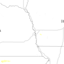


Cities Most Affected by Hail Storms of 6/23/2022
| Hail Size | Demographics of Zip Codes Affected | ||||||
|---|---|---|---|---|---|---|---|
| City | Count | Average | Largest | Pop Density | House Value | Income | Age |
| Brainerd, MN | 3 | 1.92 | 2.00 | 95 | $91k | $35.5k | 38.0 |
| Baxter, MN | 3 | 1.83 | 2.00 | 419 | $121k | $52.4k | 38.6 |
| Eagle Butte, SD | 1 | 1.75 | 1.75 | 0 | $40k | $22.4k | 25.8 |
| Pillager, MN | 1 | 1.75 | 1.75 | 41 | $94k | $40.6k | 40.9 |
Hail and Wind Damage Spotted on 6/23/2022
Filter by Report Type:Hail ReportsWind Reports
States Impacted
Florida, Virginia, Georgia, Kansas, Alabama, Arizona, Arkansas, Missouri, Montana, Utah, Minnesota, Ohio, Nevada, South Carolina, South Dakota, North DakotaFlorida
| Local Time | Report Details |
|---|---|
| 4:18 PM EDT | Multiple trees and powerlines down along ne jacksonville rd extending from 49th st to 90th st. time estimated by rada in marion county FL, 67.2 miles NW of Orlando, FL |
| 4:45 PM EDT | Corrects previous tstm wnd dmg report from 3 nw silver springs shores. multiple trees and powerlines down along se 55th pl. trees and powerlines were reported to be twi in marion county FL, 57.2 miles NW of Orlando, FL |
| 4:45 PM EDT | Multiple trees downed or snapped... power lines downed and people without power near midway rd... bahia rd and spring rd. large trees of about 8 to 10 ft in circumferen in marion county FL, 55.9 miles NW of Orlando, FL |
Virginia
| Local Time | Report Details |
|---|---|
| 4:25 PM EDT | Corrects previous tstm wnd dmg report from 2 n walton. tree down across guard rail along prices fork road across from the water treatment plan in montgomery county VA, 32.6 miles W of Roanoke, VA |
| 4:25 PM EDT | Corrects previous tstm wnd dmg report from 2 n walton. tree down across guard rail along prices fork road across from the water treatment plan in montgomery county VA, 32.6 miles W of Roanoke, VA |
Georgia
| Local Time | Report Details |
|---|---|
| 4:25 PM EDT | Numerous trees down with 1 building destroye in haralson county GA, 51.9 miles W of Atlanta, GA |
Kansas
| Local Time | Report Details |
|---|---|
| 3:54 PM CDT | Estimated 50-60 mph winds in russel in russell county KS, 25.5 miles E of Hays, KS |
| 4:32 PM CDT | Quarter sized hail reported near Russell, KS, 26.1 miles E of Hays, KS |
| 5:29 PM CDT | Half Dollar sized hail reported near Bunker Hill, KS, 35.7 miles E of Hays, KS, delayed hail report west of wilson lake. |
| 6:34 PM CDT | Ping Pong Ball sized hail reported near Luray, KS, 38.3 miles ENE of Hays, KS, report from mping: ping pong ball (1.50 in.). |
| 6:38 PM CDT | Ping Pong Ball sized hail reported near Luray, KS, 38.3 miles ENE of Hays, KS, windows broken out at bank from hail. |
| 8:17 PM CDT | Ping Pong Ball sized hail reported near Tipton, KS, 56.5 miles NE of Hays, KS |
| 8:39 PM CDT | Storm damage reported in mitchell county KS, 57.4 miles NE of Hays, KS |
| 8:42 PM CDT | Storm damage reported in mitchell county KS, 71.9 miles ENE of Hays, KS |
| 9:10 PM CDT | Half Dollar sized hail reported near Beloit, KS, 71 miles ENE of Hays, KS, quarter to half dollar hail winds 40-50mph with heavy rain. |
Alabama
| Local Time | Report Details |
|---|---|
| 4:05 PM CDT | Reports of trees and tree limbs down in the thomasville... bashi... and glover communities in northern clarke count in clarke county AL, 27.2 miles W of Camden, AL |
| 4:05 PM CDT | Damage to mobile home from fallen tre in clarke county AL, 35.1 miles W of Camden, AL |
| 6:51 PM CDT | Corrects previous tstm wnd dmg report from 4 ene ten cedar estates. a tree was blown down at weoka road and antioch roa in elmore county AL, 41.7 miles W of Auburn, AL |
| 7:00 PM CDT | A few small trees were blown down... pea size hail was reported... and winds estimated at 60 mp in elmore county AL, 39 miles W of Auburn, AL |
| 7:05 PM CDT | Several trees were blown down on central plank roa in elmore county AL, 41.4 miles W of Auburn, AL |
| 7:07 PM CDT | A tree was blown down at weoka road and antioch roa in elmore county AL, 41.7 miles W of Auburn, AL |
| 7:12 PM CDT | A few trees were blown down... one roof was damaged and a trampoline was destroye in elmore county AL, 38.4 miles W of Auburn, AL |
| 7:15 PM CDT | Trees were blown down near tallassee highway and jug factory roa in elmore county AL, 36.2 miles W of Auburn, AL |
Arizona
| Local Time | Report Details |
|---|---|
| 2:21 PM MST | Multiple reports from storm chasers and local media of multiple downed power lines... trees... and a rolled rv along sr-347 between louis johnson dr and clayton r in pinal county AZ, 37.1 miles S of Phoenix, AZ |
| 3:31 PM MST | Mesonet station as877 san tan valle in pinal county AZ, 35.9 miles ESE of Phoenix, AZ |
Arkansas
| Local Time | Report Details |
|---|---|
| 4:26 PM CDT | Quarter sized hail reported near Jasper, AR, 79 miles NE of Fort Smith, AR |
Missouri
| Local Time | Report Details |
|---|---|
| 4:38 PM CDT | A couple trees down and several branches down at roaring river state par in barry county MO, 52.1 miles SW of Springfield, MO |
Montana
| Local Time | Report Details |
|---|---|
| 3:50 PM MDT | Mesonet station 07mt 1.0 ne saint marie (ggwwfo in valley county MT, 15.8 miles NNE of Glasgow, MT |
| 6:07 PM MDT | Storm damage reported in park county MT, 28.3 miles E of Bozeman, MT |
Utah
| Local Time | Report Details |
|---|---|
| 3:51 PM MDT | Wind gust recorded by union pacific railroad senso in box elder county UT, 87.9 miles SSE of Twin Falls, ID |
| 4:40 PM MDT | Storm damage reported in tooele county UT, 83.7 miles WSW of Salt Lake City, UT |
| 4:45 PM MDT | Storm damage reported in tooele county UT, 80.2 miles SW of Salt Lake City, UT |
| 4:55 PM MDT | Storm damage reported in tooele county UT, 71.3 miles SW of Salt Lake City, UT |
| 5:00 PM MDT | Wind gust recorded by simpson springs mesonet sit in tooele county UT, 80.2 miles SW of Salt Lake City, UT |
| 5:10 PM MDT | Wind gust recorded by camel back mountain mesonet sit in tooele county UT, 71.3 miles SW of Salt Lake City, UT |
| 5:44 PM MDT | Wind gust recorded by clover mesonet sit in tooele county UT, 43.2 miles SW of Salt Lake City, UT |
| 6:10 PM MDT | Wind gust recorded by utah dot observation site at mile marker 16 on sr-6 in utah county UT, 40 miles S of Salt Lake City, UT |
| 6:10 PM MDT | Wind gust recorded by lake mountain sit in utah county UT, 33.2 miles S of Salt Lake City, UT |
| 6:50 PM MDT | Wind gust recorded on west jordan benc in salt lake county UT, 14.6 miles SW of Salt Lake City, UT |
Minnesota
| Local Time | Report Details |
|---|---|
| 5:21 PM CDT | Ping Pong Ball sized hail reported near Cushing, MN, 87.3 miles S of Bemidji, MN |
| 6:07 PM CDT | Golf Ball sized hail reported near Baxter, MN, 82.3 miles SSE of Bemidji, MN |
| 6:09 PM CDT | Ping Pong Ball sized hail reported near Baxter, MN, 81.8 miles SSE of Bemidji, MN, report via social media with photo. |
| 6:10 PM CDT | Half Dollar sized hail reported near Baxter, MN, 82 miles SSE of Bemidji, MN, report via social media with photo. |
| 6:10 PM CDT | Quarter sized hail reported near Brainerd, MN, 83 miles SSE of Bemidji, MN |
| 6:10 PM CDT | Quarter sized hail reported near Baxter, MN, 82 miles SSE of Bemidji, MN, report from mping: quarter (1.00 in.). |
| 6:13 PM CDT | Ping Pong Ball sized hail reported near Baxter, MN, 82 miles SSE of Bemidji, MN, report from mping: ping pong ball (1.50 in.). |
| 6:15 PM CDT | Golf Ball sized hail reported near Baxter, MN, 81.1 miles SSE of Bemidji, MN, two rounds of golf ball size hail... with the first round being about 15 minutes earlier than the time listed. location approximate. report received via facebook. |
| 6:26 PM CDT | Quarter sized hail reported near Baxter, MN, 84.3 miles SSE of Bemidji, MN |
| 6:27 PM CDT | Quarter sized hail reported near Brainerd, MN, 83 miles SSE of Bemidji, MN |
| 6:29 PM CDT | Quarter sized hail reported near Brainerd, MN, 83.1 miles SSE of Bemidji, MN, report via social media with measurement picture. |
| 6:38 PM CDT | Quarter sized hail reported near Ironton, MN, 81.8 miles SSE of Bemidji, MN |
| 6:39 PM CDT | Quarter sized hail reported near Brainerd, MN, 84 miles SSE of Bemidji, MN, report from mping: quarter (1.00 in.). |
| 6:40 PM CDT | Quarter sized hail reported near Crosby, MN, 80.6 miles SSE of Bemidji, MN |
| 6:40 PM CDT | Ping Pong Ball sized hail reported near Baxter, MN, 82.6 miles SSE of Bemidji, MN, report via social media with ruler photo. |
| 6:40 PM CDT | Golf Ball sized hail reported near Brainerd, MN, 84.4 miles SSE of Bemidji, MN |
| 6:45 PM CDT | Hen Egg sized hail reported near Baxter, MN, 82 miles SSE of Bemidji, MN, report via social media with photo. |
| 6:46 PM CDT | Quarter sized hail reported near Deerwood, MN, 82 miles SSE of Bemidji, MN, report from mping: quarter (1.00 in.). |
| 6:50 PM CDT | Quarter sized hail reported near Deerwood, MN, 82 miles SSE of Bemidji, MN |
| 6:55 PM CDT | Quarter sized hail reported near Deerwood, MN, 83.3 miles SE of Bemidji, MN, report via social media with photo. |
| 7:00 PM CDT | Quarter sized hail reported near Brainerd, MN, 91.3 miles SSE of Bemidji, MN, report via social media with photo. |
| 7:20 PM CDT | Corrects previous tstm wnd dmg report from 7 ese brainerd. large tree snapped roughly 5 feet up from base. report with phot in crow wing county MN, 89.8 miles SSE of Bemidji, MN |
| 7:20 PM CDT | Corrects previous tstm wnd dmg report from 7 ese brainerd. large tree snapped roughly 5 feet up from base. report with phot in crow wing county MN, 89.8 miles SSE of Bemidji, MN |
| 7:25 PM CDT | Quarter sized hail reported near Pillager, MN, 82.2 miles SSE of Bemidji, MN, delayed report... time estimated from radar. |
| 7:35 PM CDT | Golf Ball sized hail reported near Pillager, MN, 81.5 miles SSE of Bemidji, MN |
| 7:35 PM CDT | Ping Pong Ball sized hail reported near Pillager, MN, 81.2 miles SSE of Bemidji, MN, report via social media with photo. |
| 7:35 PM CDT | Quarter sized hail reported near Aitkin, MN, 79.8 miles WSW of Duluth, MN |
| 7:36 PM CDT | Quarter sized hail reported near Mcgregor, MN, 55.3 miles WSW of Duluth, MN |
| 7:40 PM CDT | Report via social media with photos of multiple medium to large trees snapped at base down over roads and power lines. time estimated from report and rada in aitkin county MN, 56.9 miles WSW of Duluth, MN |
| 7:50 PM CDT | Quarter sized hail reported near Mcgregor, MN, 53.7 miles WSW of Duluth, MN |
| 7:50 PM CDT | Hen Egg sized hail reported near Brainerd, MN, 86.5 miles SSE of Bemidji, MN, report via social media with photo. |
| 7:52 PM CDT | Quarter sized hail reported near Baxter, MN, 82.9 miles SSE of Bemidji, MN |
| 7:55 PM CDT | Report 1 medium size tree snapped at base in backyar in crow wing county MN, 83.3 miles SSE of Bemidji, MN |
| 7:55 PM CDT | Quarter sized hail reported near Baxter, MN, 83.3 miles SSE of Bemidji, MN |
| 7:55 PM CDT | Half Dollar sized hail reported near Palisade, MN, 65.3 miles W of Duluth, MN, report via social media with photo. |
| 8:02 PM CDT | Hen Egg sized hail reported near Brainerd, MN, 88.5 miles SSE of Bemidji, MN, report received via facebook. pictures and video show hail sizes measured up to 2 inches in diameter. |
| 8:04 PM CDT | Quarter sized hail reported near Cromwell, MN, 37.3 miles WSW of Duluth, MN, report via social media with photo. |
| 8:07 PM CDT | Quarter sized hail reported near Palisade, MN, 62.4 miles W of Duluth, MN, some quarter size hailstones with lots of smaller stones. |
| 8:10 PM CDT | Ping Pong Ball sized hail reported near Mcgregor, MN, 56.5 miles W of Duluth, MN, report via social media with ruler photo. |
| 8:11 PM CDT | Quarter sized hail reported near Mcgregor, MN, 56 miles W of Duluth, MN, report via social media with photo. |
| 8:15 PM CDT | Quarter sized hail reported near Barnum, MN, 29.4 miles WSW of Duluth, MN, report via social media with picture. |
| 8:42 PM CDT | Half Dollar sized hail reported near Fort Ripley, MN, 91.2 miles SSE of Bemidji, MN, report via social media with picture. |
| 8:45 PM CDT | Quarter sized hail reported near Brainerd, MN, 90.8 miles SSE of Bemidji, MN |
| 9:05 PM CDT | Half Dollar sized hail reported near Fort Ripley, MN, 92.7 miles SSE of Bemidji, MN |
| 9:07 PM CDT | Half Dollar sized hail reported near Fort Ripley, MN, 93.3 miles SSE of Bemidji, MN |
| 9:16 PM CDT | Quarter sized hail reported near Duluth, MN, 13.8 miles NNW of Duluth, MN |
| 9:25 PM CDT | Ping Pong Ball sized hail reported near Fort Ripley, MN, 93.4 miles SSE of Bemidji, MN |
| 9:35 PM CDT | Quarter sized hail reported near Fort Ripley, MN, 93.3 miles SSE of Bemidji, MN |
| 9:49 PM CDT | Quarter sized hail reported near Duluth, MN, 13.4 miles N of Duluth, MN, report via social media with photo. |
| 1:55 AM CDT | Quarter sized hail reported near Saint Cloud, MN, 59.9 miles NW of Minneapolis, MN |
| 2:30 AM CDT | Quarter sized hail reported near Saint Cloud, MN, 60.7 miles NW of Minneapolis, MN |
Ohio
| Local Time | Report Details |
|---|---|
| 6:38 PM EDT | Tree dow in vinton county OH, 63.2 miles SSE of Columbus, OH |
| 7:15 PM EDT | 5 trees down all along horton sisters r in jackson county OH, 69.1 miles NW of Charleston, WV |
Nevada
| Local Time | Report Details |
|---|---|
| 3:59 PM PDT | A 69 mph thunderstorm outflow wind gust was measured at the buffalo creek raw in washoe county NV, 72.6 miles N of Reno, NV |
| 5:00 PM PDT | Mesonet station cw8738 ren in washoe county NV, 22.8 miles NNE of Reno, NV |
| 8:15 PM PDT | Wind gusts above 58 mph began at 8pm and ended at 930pm. peak gust of 84 mph at 81 in nye county NV, 87.6 miles WNW of Las Vegas, NV |
| 8:45 PM PDT | Wind gust above 58 mph at 845p in nye county NV, 67.5 miles NW of Las Vegas, NV |
South Carolina
| Local Time | Report Details |
|---|---|
| 7:12 PM EDT | Trees down on old airport rd and jackson creek rd. time estimate in fairfield county SC, 61.4 miles SSW of Charlotte, NC |
| 7:15 PM EDT | Trees down on armstrong rd. time estimate in fairfield county SC, 59.5 miles SSW of Charlotte, NC |
| 7:20 PM EDT | Trees down on hwy 213 and jackson creek rd. time estimate in fairfield county SC, 62.6 miles SSW of Charlotte, NC |
| 7:20 PM EDT | Tree down near hwy 269 and rion rd near the greenbrier fire statio in fairfield county SC, 64.9 miles SSW of Charlotte, NC |
| 7:25 PM EDT | Trees down at reservoir rd and new hope rd. time estimate in fairfield county SC, 65 miles SSW of Charlotte, NC |
| 7:25 PM EDT | Trees down on corona dr. time estimate in fairfield county SC, 64.5 miles SSW of Charlotte, NC |
| 7:35 PM EDT | Trees down and power poles broken at 16044 hwy 215 s. time estimate in fairfield county SC, 67.6 miles NE of Augusta, GA |
| 8:13 PM EDT | Colleton county emergency manager reported a tree down on road at 1400 block of penny creek drive and a tree down on mobile home at 4900 block of bells highway. there w in colleton county SC, 45.8 miles WSW of Charleston, SC |
| 9:10 PM EDT | Tree down on stabler hill rd and foxglove dr. time estimate in calhoun county SC, 62.3 miles ENE of Augusta, GA |
| 9:15 PM EDT | Tree down on hayden rd near woodford. time estimate in orangeburg county SC, 51.1 miles ENE of Augusta, GA |
| 9:15 PM EDT | Tree down at 11434 north rd... nw of north... near salem baptist church. time estimate in orangeburg county SC, 49.1 miles ENE of Augusta, GA |
| 9:20 PM EDT | Tree down on bull swamp rd and fringetree rd. time estimate in calhoun county SC, 61.9 miles ENE of Augusta, GA |
| 9:22 PM EDT | Tree down near bull swamp rd and a z rd. time estimate in calhoun county SC, 58.8 miles ENE of Augusta, GA |
| 9:24 PM EDT | Tree down on power line at 1700 old state rd in st. matthews. time estimate in calhoun county SC, 57.4 miles NW of Charleston, SC |
| 10:32 PM EDT | Multiple trees down on belthel rd and hunters chapel rd in bamber in bamberg county SC, 56.1 miles W of Charleston, SC |
| 10:40 PM EDT | Multiple trees down across clear pond r in bamberg county SC, 56.6 miles W of Charleston, SC |
South Dakota
| Local Time | Report Details |
|---|---|
| 8:00 PM MDT | Golf Ball sized hail reported near Eagle Butte, SD, 50.7 miles NW of Pierre, SD, 50 to 60 mph winds reported as well. |
North Dakota
| Local Time | Report Details |
|---|---|
| 9:17 PM CDT | Quarter sized hail reported near Minot, ND, 5.2 miles SE of Minot, ND, twitter photo of dime to quarter size hail. time estimated from radar. |
| 9:18 PM CDT | Mesonet station dw7576 newbur in bottineau county ND, 41.2 miles NNE of Minot, ND |
| 9:41 PM CDT | Quarter sized hail reported near Bottineau, ND, 55.5 miles NE of Minot, ND, facebook photo of hail estimated to be 1 inch in diameter. the hail lasted for about a minute according to report. |
Connect with Interactive Hail Maps