

Hail Map for Tuesday, June 7, 2022

Number of Impacted Households on 6/7/2022
0
Impacted by 1" or Larger Hail
0
Impacted by 1.75" or Larger Hail
0
Impacted by 2.5" or Larger Hail
Square Miles of Populated Area Impacted on 6/7/2022
0
Impacted by 1" or Larger Hail
0
Impacted by 1.75" or Larger Hail
0
Impacted by 2.5" or Larger Hail


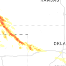


Cities Most Affected by Hail Storms of 6/7/2022
| Hail Size | Demographics of Zip Codes Affected | ||||||
|---|---|---|---|---|---|---|---|
| City | Count | Average | Largest | Pop Density | House Value | Income | Age |
| Ravenna, NE | 5 | 2.80 | 4.00 | 11 | $53k | $31.4k | 43.3 |
| Hastings, NE | 4 | 2.13 | 2.50 | 184 | $78k | $36.9k | 37.0 |
| Burlington, CO | 4 | 1.94 | 2.00 | 6 | $85k | $34.7k | 38.4 |
| Oberlin, KS | 3 | 2.33 | 2.75 | 5 | $49k | $31.7k | 50.5 |
| Guymon, OK | 3 | 2.08 | 2.75 | 21 | $71k | $37.3k | 31.3 |
| La Junta, CO | 2 | 2.25 | 2.75 | 19 | $69k | $30.5k | 39.2 |
| Jennings, KS | 2 | 2.13 | 2.50 | 1 | $15k | $21.7k | 56.6 |
| Bethune, CO | 2 | 1.88 | 2.00 | 1 | $54k | $30.5k | 38.2 |
| Las Animas, CO | 2 | 1.75 | 1.75 | 3 | $56k | $27.1k | 39.3 |
| Walsh, CO | 1 | 3.50 | 3.50 | 0 | $49k | $29.9k | 46.8 |
| Genoa, NE | 2 | 1.75 | 1.75 | 5 | $52k | $32.4k | 41.5 |
| Karval, CO | 2 | 1.75 | 1.75 | 0 | $40k | $29.5k | 46.4 |
| Eagle, NE | 1 | 2.75 | 2.75 | 59 | $103k | $53.8k | 37.3 |
| Julesburg, CO | 1 | 2.50 | 2.50 | 6 | $62k | $28.8k | 48.8 |
| Culbertson, NE | 1 | 2.50 | 2.50 | 3 | $42k | $33.3k | 45.9 |
| Hazard, NE | 1 | 2.50 | 2.50 | 5 | $39k | $27.8k | 44.0 |
| Venango, NE | 1 | 2.50 | 2.50 | 1 | $31k | $29.8k | 49.6 |
| Stanberry, MO | 1 | 2.00 | 2.00 | 17 | $45k | $31.2k | 37.1 |
| Wood River, NE | 1 | 2.00 | 2.00 | 9 | $70k | $38.5k | 40.2 |
| Perryton, TX | 1 | 2.00 | 2.00 | 13 | $49k | $38.0k | 31.5 |
| Columbus, NE | 1 | 2.00 | 2.00 | 100 | $82k | $40.2k | 38.0 |
| Omaha, NE | 1 | 2.00 | 2.00 | 3385 | $110k | $45.1k | 34.1 |
| Shelton, NE | 1 | 2.00 | 2.00 | 10 | $64k | $37.8k | 39.0 |
| Imperial, NE | 1 | 2.00 | 2.00 | 2 | $67k | $34.4k | 41.3 |
| Elkhart, KS | 1 | 2.00 | 2.00 | 2 | $83k | $49.2k | 38.3 |
| Peyton, CO | 1 | 2.00 | 2.00 | 127 | $173k | $54.4k | 36.2 |
| Friend, NE | 1 | 2.00 | 2.00 | 12 | $73k | $35.6k | 45.3 |
| Guilford, MO | 1 | 2.00 | 2.00 | 6 | $11k | $32.9k | 43.2 |
| Akron, CO | 1 | 2.00 | 2.00 | 2 | $73k | $31.6k | 44.7 |
| Benkelman, NE | 1 | 2.00 | 2.00 | 3 | $33k | $26.9k | 46.8 |
| Sharon Springs, KS | 1 | 2.00 | 2.00 | 1 | $47k | $34.4k | 46.0 |
| Calhan, CO | 1 | 2.00 | 2.00 | 17 | $121k | $42.2k | 39.6 |
| Herndon, KS | 1 | 1.75 | 1.75 | 1 | $22k | $25.2k | 53.3 |
| Mc Cool Junction, NE | 1 | 1.75 | 1.75 | 6 | $69k | $36.7k | 40.8 |
| Amherst, CO | 1 | 1.75 | 1.75 | 2 | $78k | $36.5k | 36.4 |
| Palisade, NE | 1 | 1.75 | 1.75 | 2 | $33k | $24.9k | 48.5 |
| Ordway, CO | 1 | 1.75 | 1.75 | 4 | $56k | $25.3k | 40.0 |
| Valparaiso, NE | 1 | 1.75 | 1.75 | 10 | $82k | $44.2k | 44.0 |
| Trenton, NE | 1 | 1.75 | 1.75 | 1 | $38k | $26.8k | 49.1 |
| Farnsworth, TX | 1 | 1.75 | 1.75 | 0 | $61k | $43.8k | 38.3 |
| Reydon, OK | 1 | 1.75 | 1.75 | 3 | $31k | $29.8k | 40.0 |
| Weskan, KS | 1 | 1.75 | 1.75 | 1 | $52k | $32.9k | 34.3 |
| Ansley, NE | 1 | 1.75 | 1.75 | 3 | $23k | $28.3k | 45.9 |
| Cairo, NE | 1 | 1.75 | 1.75 | 6 | $69k | $36.3k | 38.6 |
| Beatrice, NE | 1 | 1.75 | 1.75 | 70 | $73k | $35.2k | 43.5 |
| Ceresco, NE | 1 | 1.75 | 1.75 | 11 | $94k | $48.9k | 40.9 |
| Inland, NE | 1 | 1.75 | 1.75 | 4 | $55k | $40.2k | 50.3 |
| Stratford, OK | 1 | 1.75 | 1.75 | 19 | $46k | $26.5k | 38.2 |
| Mullen, NE | 1 | 1.75 | 1.75 | 0 | $41k | $28.7k | 49.6 |
| Rapid City, SD | 1 | 1.75 | 1.75 | 111 | $119k | $47.4k | 44.3 |
| Stratton, NE | 1 | 1.75 | 1.75 | 1 | $38k | $26.1k | 50.9 |
| Rush, CO | 1 | 1.75 | 1.75 | 1 | $105k | $34.3k | 43.5 |
| Hampton, NE | 1 | 1.75 | 1.75 | 8 | $73k | $45.5k | 45.6 |
Hail and Wind Damage Spotted on 6/7/2022
Filter by Report Type:Hail ReportsWind Reports
States Impacted
Oklahoma, Arkansas, South Dakota, Colorado, Tennessee, Nebraska, Wyoming, Missouri, Indiana, Alabama, Iowa, Kansas, New Mexico, TexasOklahoma
| Local Time | Report Details |
|---|---|
| 7:12 AM CDT | Half Dollar sized hail reported near Stratford, OK, 54 miles SSE of Oklahoma City, OK, 1.25 inch hail. |
| 7:16 AM CDT | Golf Ball sized hail reported near Stratford, OK, 54.2 miles WNW of Atoka, OK, golf ball sized hail. |
| 7:40 AM CDT | 73 mph gust at the washington mesonet sit in mcclain county OK, 33.9 miles S of Oklahoma City, OK |
| 7:45 AM CDT | 82 mph wind gust at the washington mesonet sit in mcclain county OK, 33.9 miles S of Oklahoma City, OK |
| 8:12 AM CDT | Emergency manager reports numerous areas of tree damage and power line damage between pauls valley and stratfor in garvin county OK, 50.9 miles SSE of Oklahoma City, OK |
| 8:25 AM CDT | 72 mph wind gust at byars mesonet sit in mcclain county OK, 51.5 miles SE of Oklahoma City, OK |
| 8:50 AM CDT | 71 mph wind gust at fittstown mesonet sit in pontotoc county OK, 35.1 miles WNW of Atoka, OK |
| 9:10 PM CDT | Ok mesonet at eva. first gust of 72 mph at 9:05 pm and severe gusts continued through 9:15 p in texas county OK, 87.9 miles SW of Garden City, KS |
| 9:53 PM CDT | Storm damage reported in texas county OK, 95.1 miles SSW of Garden City, KS |
| 10:00 PM CDT | Golf Ball sized hail reported near Guymon, OK, 94.3 miles SSW of Garden City, KS, time estimated by radar data. accumulating hail to around one inch deep in spots. |
| 10:00 PM CDT | Baseball sized hail reported near Guymon, OK, 93.7 miles SSW of Garden City, KS, time estimated by radar data. |
| 10:05 PM CDT | Storm damage reported in texas county OK, 95.1 miles SSW of Garden City, KS |
| 10:05 PM CDT | Storm damage reported in texas county OK, 96.2 miles N of Amarillo, TX |
| 10:26 PM CDT | Golf Ball sized hail reported near Guymon, OK, 93.2 miles NNE of Amarillo, TX, time estimated by radar data. |
| 3:40 AM CDT | Gusted 60 mph at 3:40 am... max gust 66 mph at 3:45 am... finished with a gust of 59 at 3:50 a in texas county OK, 87.9 miles SW of Garden City, KS |
| 4:15 AM CDT | Asos station kguy guymon (asos in texas county OK, 95.4 miles SSW of Garden City, KS |
| 4:28 AM CDT | Asos station kguy guymon (asos in texas county OK, 95.4 miles SSW of Garden City, KS |
| 4:40 AM CDT | Mesonet station good goodwell. 60 mph gusts occurred at the 435am and 440 am cdt observation in texas county OK, 96.9 miles N of Amarillo, TX |
| 5:40 AM CDT | Quarter sized hail reported near Crawford, OK, 46.8 miles SSW of Woodward, OK, corrects previous hail report from 1 e crawford. |
| 5:44 AM CDT | Quarter sized hail reported near Crawford, OK, 46.8 miles SSW of Woodward, OK |
| 6:29 AM CDT | Golf Ball sized hail reported near Reydon, OK, 60.9 miles SSW of Woodward, OK |
| 6:41 AM CDT | Quarter sized hail reported near Cheyenne, OK, 58.8 miles SSW of Woodward, OK |
Arkansas
| Local Time | Report Details |
|---|---|
| 10:49 AM CDT | Spotter on old untiontown road estimated thunderstorm wind gust to 60 mp in crawford county AR, 7.2 miles NNE of Fort Smith, AR |
| 3:27 PM CDT | Tree down on us 6 in cross county AR, 55.8 miles W of Memphis, TN |
South Dakota
| Local Time | Report Details |
|---|---|
| 12:30 PM MDT | Quarter sized hail reported near Piedmont, SD, 13.8 miles NW of Rapid City, SD, largest was quarter sized... mostly smaller hail covering the ground |
| 12:33 PM MDT | Half Dollar sized hail reported near Piedmont, SD, 13.8 miles NW of Rapid City, SD, hail size increased in last few minutes |
| 1:05 PM MDT | Quarter sized hail reported near Sturgis, SD, 25.3 miles NNW of Rapid City, SD, hail covering the ground |
| 2:00 PM MDT | Golf Ball sized hail reported near Rapid City, SD, 13.8 miles WSW of Rapid City, SD, large hail lasted for several minutes... still some small hail about ten minutes after hail started |
| 2:01 PM MDT | Quarter sized hail reported near Rapid City, SD, 0.9 miles W of Rapid City, SD |
| 2:05 PM MDT | Quarter sized hail reported near Rapid City, SD, 0.9 miles W of Rapid City, SD |
Colorado
| Local Time | Report Details |
|---|---|
| 1:25 PM MDT | Ping Pong Ball sized hail reported near Peyton, CO, 48.7 miles N of Pueblo, CO, cocorahs spotter measured 1.63-inch hail with earlier severe storm. |
| 1:45 PM MDT | Quarter sized hail reported near Peyton, CO, 48.7 miles N of Pueblo, CO |
| 1:45 PM MDT | Ping Pong Ball sized hail reported near Peyton, CO, 48.7 miles N of Pueblo, CO, trained spotter measured 1.6-inch hail with a severe thunderstorm that passed through the falcon area. |
| 1:55 PM MDT | Hen Egg sized hail reported near Peyton, CO, 48.9 miles N of Pueblo, CO, picture emailed from trained spotter. |
| 1:58 PM MDT | Ping Pong Ball sized hail reported near Peyton, CO, 47.4 miles N of Pueblo, CO |
| 2:22 PM MDT | Quarter sized hail reported near Trinidad, CO, 74.3 miles S of Pueblo, CO, report of hail up to quarter-size on the north side of trinidad with earlier severe thunderstorm. |
| 2:29 PM MDT | Hen Egg sized hail reported near Calhan, CO, 45.5 miles NNE of Pueblo, CO, picture relayed via social media. |
| 3:10 PM MDT | Half Dollar sized hail reported near Byers, CO, 41.2 miles E of Denver, CO, delayed report via social media. photo of several quarter to half dollar hailstones in byers. |
| 3:15 PM MDT | Quarter sized hail reported near Deer Trail, CO, 51 miles E of Denver, CO |
| 3:29 PM MDT | Quarter sized hail reported near Rush, CO, 55.8 miles NE of Pueblo, CO |
| 3:30 PM MDT | Quarter sized hail reported near Woodrow, CO, 48 miles WSW of Yuma, CO |
| 3:35 PM MDT | Half Dollar sized hail reported near Pueblo, CO, 18.5 miles SSW of Pueblo, CO, time estimated from radar. |
| 3:35 PM MDT | Golf Ball sized hail reported near Rush, CO, 55.7 miles NE of Pueblo, CO |
| 3:42 PM MDT | Quarter sized hail reported near Peyton, CO, 48.7 miles N of Pueblo, CO, hail to quarter size ongoing as reported by trained spotter. |
| 4:19 PM MDT | Quarter sized hail reported near Akron, CO, 25.3 miles WSW of Yuma, CO |
| 4:20 PM MDT | Golf Ball sized hail reported near La Junta, CO, 66 miles ESE of Pueblo, CO |
| 4:31 PM MDT | Quarter sized hail reported near Yuma, CO, 3.9 miles ESE of Yuma, CO, spotter reported dime to quarter hail. hail ongoing as of 4:35 pm. |
| 4:41 PM MDT | Quarter sized hail reported near Las Animas, CO, 76.4 miles E of Pueblo, CO, observed from las animas dollar general. |
| 5:04 PM MDT | Storm damage reported in sedgwick county CO, 60.4 miles N of Yuma, CO |
| 5:17 PM MDT | Tennis Ball sized hail reported near Julesburg, CO, 59.2 miles NNE of Yuma, CO |
| 5:20 PM MDT | Half Dollar sized hail reported near Vona, CO, 43.5 miles S of Yuma, CO, caller reported quarter to half dollar sized hail that lasted for duration of 5 minutes. |
| 5:20 PM MDT | Caller reported 60 to 70 mph wind in kit carson county CO, 43.5 miles S of Yuma, CO |
| 5:29 PM MDT | Quarter sized hail reported near Sedgwick, CO, 52.8 miles N of Yuma, CO, hail lasted approximately 10 minutes. time estimated by radar. |
| 5:40 PM MDT | Half Dollar sized hail reported near Ordway, CO, 53 miles ENE of Pueblo, CO |
| 5:46 PM MDT | Golf Ball sized hail reported near Bethune, CO, 58.7 miles SSE of Yuma, CO, spotter reported hail ranging from dime to golfball in size for an ongoing duration of 10 minutes as of 5:56 pm mt. small tree limbs were damaged due to hail. |
| 5:50 PM MDT | Quarter sized hail reported near Bethune, CO, 53.7 miles SSE of Yuma, CO, spotter reported quarter sized hail accumulating to a depth of 1 inch. hail lasted for 6 minutes. |
| 5:50 PM MDT | Ping Pong Ball sized hail reported near Burlington, CO, 61.2 miles SSE of Yuma, CO, reported via social media. hail varied in size from quarter to ping pong ball. hail finished by 6:10 pm mt. |
| 5:53 PM MDT | Hen Egg sized hail reported near Bethune, CO, 58.7 miles SSE of Yuma, CO, dime to two size hail. |
| 5:57 PM MDT | Golf Ball sized hail reported near Burlington, CO, 59.9 miles SSE of Yuma, CO, at least golf ball hail... smashed windshield of person on interstate 70. |
| 6:00 PM MDT | Golf Ball sized hail reported near Amherst, CO, 48.2 miles NE of Yuma, CO |
| 6:00 PM MDT | Storm damage reported in kit carson county CO, 61.2 miles SSE of Yuma, CO |
| 6:03 PM MDT | Quarter sized hail reported near Holyoke, CO, 46.2 miles NE of Yuma, CO, report from mping: quarter (1.00 in.). |
| 6:04 PM MDT | Asos station kitr burlington co airpor in kit carson county CO, 65.7 miles SSE of Yuma, CO |
| 6:05 PM MDT | Hen Egg sized hail reported near Burlington, CO, 64.4 miles SSE of Yuma, CO, reported via social media. |
| 6:05 PM MDT | Hen Egg sized hail reported near Burlington, CO, 60.6 miles WSW of Colby, KS, corrects previous hail report from 1 e burlington. reported via social media. broken windows and one whole side of a mobile home had siding and under pining ripped off |
| 6:05 PM MDT | Hen Egg sized hail reported near Burlington, CO, 61.6 miles SSE of Yuma, CO, reported via social media. broken windows and one whole side of a mobile home had siding and under pining ripped off the house to the plywood underneath. time estimated |
| 6:06 PM MDT | Quarter sized hail reported near Burlington, CO, 60.8 miles SSE of Yuma, CO, multiple social media report of quarter sized hail. large amounts of hail fell in the city. |
| 6:08 PM MDT | Ping Pong Ball sized hail reported near Burlington, CO, 61.6 miles SSE of Yuma, CO, reported via social media. time estimated. |
| 6:12 PM MDT | Storm damage reported in kit carson county CO, 63.4 miles WSW of Colby, KS |
| 6:22 PM MDT | Storm damage reported in kit carson county CO, 62.7 miles W of Colby, KS |
| 6:23 PM MDT | Quarter sized hail reported near Wiley, CO, 101.8 miles W of Garden City, KS, report from mping: quarter (1.00 in.). |
| 6:28 PM MDT | Quarter sized hail reported near Mc Clave, CO, 97 miles E of Pueblo, CO |
| 6:45 PM MDT | Baseball sized hail reported near La Junta, CO, 69.9 miles E of Pueblo, CO |
| 6:51 PM MDT | Golf Ball sized hail reported near Las Animas, CO, 79.9 miles E of Pueblo, CO, corrects time of previous hail report from 1 w fort lyon. picture via social media. |
| 7:01 PM MDT | Quarter sized hail reported near Lamar, CO, 94.8 miles W of Garden City, KS, report from mping: quarter (1.00 in.). |
| 7:05 PM MDT | Golf Ball sized hail reported near Las Animas, CO, 79.9 miles E of Pueblo, CO, picture via social media. |
| 8:00 PM MDT | Ping Pong Ball sized hail reported near Granada, CO, 77.7 miles WSW of Garden City, KS |
| 8:05 PM MDT | Ping Pong Ball sized hail reported near Akron, CO, 24.2 miles W of Yuma, CO, report via facebook. |
| 8:05 PM MDT | Half Dollar sized hail reported near Akron, CO, 26.5 miles W of Yuma, CO |
| 8:10 PM MDT | Hen Egg sized hail reported near Akron, CO, 23.8 miles W of Yuma, CO, location estimated. source: social media photo. |
| 8:18 PM MDT | Tea Cup sized hail reported near Walsh, CO, 72.7 miles WSW of Garden City, KS |
| 8:54 PM MDT | Quarter sized hail reported near Ramah, CO, 58.9 miles NE of Pueblo, CO |
| 9:12 PM MDT | Golf Ball sized hail reported near Karval, CO, 66.7 miles ENE of Pueblo, CO, ground covered... but mostly with smaller marble to quarter sized hail. |
| 9:15 PM MDT | Quarter sized hail reported near Karval, CO, 66.7 miles ENE of Pueblo, CO |
| 9:16 PM MDT | Golf Ball sized hail reported near Karval, CO, 65.9 miles ENE of Pueblo, CO |
| 10:13 PM MDT | Golf Ball sized hail reported near Ordway, CO, 53 miles ENE of Pueblo, CO |
| 12:00 AM MDT | Power outages and multiple downed trees reporte in prowers county CO, 101.6 miles W of Garden City, KS |
Tennessee
| Local Time | Report Details |
|---|---|
| 2:30 PM CDT | Multiple trees were knocked down along highway 50 east of lynchburg. time estimated by rada in moore county TN, 61.3 miles WNW of Chattanooga, TN |
| 5:29 PM CDT | Quarter sized hail reported near Cookeville, TN, 70.4 miles E of Nashville, TN, tspotter coordinator reported quarter size hail near jackson street at buffalo valley road. |
| 5:35 PM CDT | Ping Pong Ball sized hail reported near Cookeville, TN, 70.9 miles E of Nashville, TN, twitter report and photo indicated silver dollar size hail fell on willow ave in cookeville. hail was very jagged and spiky. |
| 5:35 PM CDT | Trees down at west jackson st and west stevens s in putnam county TN, 70.4 miles E of Nashville, TN |
| 5:40 PM CDT | Quarter sized hail reported near Cookeville, TN, 70.9 miles E of Nashville, TN, numerous reports of pea to quarter size hail across the city of cookeville. hail fell for 5 minutes in some locations. |
Nebraska
| Local Time | Report Details |
|---|---|
| 1:57 PM MDT | Half Dollar sized hail reported near Gering, NE, 2.2 miles S of Scottsbluff, NE, report just southwest of gering. |
| 2:00 PM MDT | Ping Pong Ball sized hail reported near Gering, NE, 3.8 miles SSW of Scottsbluff, NE |
| 2:35 PM MDT | Quarter sized hail reported near Bayard, NE, 19.6 miles SE of Scottsbluff, NE |
| 2:40 PM MDT | Quarter sized hail reported near Ashby, NE, 80 miles WSW of Valentine, NE, quarter size hail reported by the public. |
| 2:42 PM MDT | Penny size hai in box butte county NE, 43.6 miles NE of Scottsbluff, NE |
| 2:54 PM MDT | Quarter sized hail reported near Bridgeport, NE, 38.7 miles ESE of Scottsbluff, NE, spotter was not in hail core. said there likely was larger hail in the hail core. |
| 3:42 PM MDT | Penny size hail. corrected tim in box butte county NE, 43.6 miles NE of Scottsbluff, NE |
| 3:46 PM MDT | Quarter sized hail reported near Mullen, NE, 61.2 miles SSW of Valentine, NE, quarter size hail. |
| 3:46 PM MDT | Golf Ball sized hail reported near Mullen, NE, 64.9 miles SSW of Valentine, NE, ping pong to golf ball size hail. |
| 3:50 PM MDT | Quarter sized hail reported near Potter, NE, 46.5 miles SSE of Scottsbluff, NE |
| 3:59 PM MDT | Quarter sized hail reported near Potter, NE, 51.8 miles SSE of Scottsbluff, NE |
| 4:00 PM MDT | Quarter sized hail reported near Sidney, NE, 54 miles SSE of Scottsbluff, NE, 60 mph wind estimated. |
| 4:00 PM MDT | Gudmundsen in grant county NE, 71.7 miles SW of Valentine, NE |
| 4:12 PM MDT | Storm damage reported in box butte county NE, 46.5 miles ENE of Scottsbluff, NE |
| 4:15 PM MDT | Quarter sized hail reported near Alliance, NE, 44 miles ENE of Scottsbluff, NE, reported estimated 60 mph winds as well. |
| 4:22 PM MDT | Half Dollar sized hail reported near Sidney, NE, 64 miles SE of Scottsbluff, NE, most hail was quarter sized. but some larger. |
| 4:35 PM MDT | Large branches down... estimated 70 mp in sheridan county NE, 57.1 miles ENE of Scottsbluff, NE |
| 5:44 PM CDT | Ping Pong Ball sized hail reported near Stapleton, NE, 45.5 miles NNE of North Platte, NE, lots of hail with the largest being ping pong ball size. |
| 6:10 PM CDT | Ping Pong Ball sized hail reported near Stapleton, NE, 40.6 miles NE of North Platte, NE, hail stripped leaves off of trees. |
| 5:40 PM MDT | Quarter sized hail reported near Venango, NE, 57.1 miles NE of Yuma, CO, quarter size hail in venango. |
| 5:53 PM MDT | Tennis Ball sized hail reported near Venango, NE, 56.8 miles NE of Yuma, CO, storm chaser reported tennis ball sized hail. gustnadoes also reported. |
| 5:55 PM MDT | Quarter sized hail reported near Imperial, NE, 60.2 miles NE of Yuma, CO |
| 7:00 PM CDT | Ping Pong Ball sized hail reported near Broken Bow, NE, 55.5 miles ENE of North Platte, NE |
| 7:17 PM CDT | Ping Pong Ball sized hail reported near Sterling, NE, 55.1 miles SSW of Omaha, NE, lasted about 8 minutes - 719 pm to 727 pm. |
| 7:19 PM CDT | Storm damage reported in boone county NE, 46.6 miles NNE of Grand Island, NE |
| 6:24 PM MDT | Quarter sized hail reported near Imperial, NE, 61.2 miles SW of North Platte, NE |
| 6:25 PM MDT | Hen Egg sized hail reported near Imperial, NE, 62.6 miles SW of North Platte, NE, 2 inch diameter hail... most closer to golfball size. |
| 7:29 PM CDT | Golf Ball sized hail reported near Ansley, NE, 59.9 miles WNW of Grand Island, NE |
| 7:29 PM CDT | Power poles are down across the track in custer county NE, 59.9 miles WNW of Grand Island, NE |
| 7:32 PM CDT | Quarter sized hail reported near Cook, NE, 53.7 miles SSW of Omaha, NE |
| 7:35 PM CDT | Quarter sized hail reported near Cook, NE, 53.1 miles SSW of Omaha, NE |
| 7:35 PM CDT | Golf Ball sized hail reported near Genoa, NE, 50.9 miles NE of Grand Island, NE, pea to golf ball size hail reported. |
| 7:37 PM CDT | Golf Ball sized hail reported near Genoa, NE, 49.6 miles NE of Grand Island, NE, hail up to the size of golf balls reported. accompanied by wind gusts of at least 60 mph. |
| 6:37 PM MDT | Power out in waunet in chase county NE, 58.8 miles SSW of North Platte, NE |
| 7:39 PM CDT | Gusts est. near 70 mph relayed by e in sherman county NE, 48.3 miles WNW of Grand Island, NE |
| 7:40 PM CDT | Received photo via facebook of siding damage to a home due to wind driven large hai in sherman county NE, 45.3 miles WNW of Grand Island, NE |
| 7:45 PM CDT | Tennis Ball sized hail reported near Hazard, NE, 39.7 miles WNW of Grand Island, NE, received photo via facebook with largest stone around tennis ball size. |
| 7:52 PM CDT | Tea Cup sized hail reported near Ravenna, NE, 37.1 miles WNW of Grand Island, NE, em reported hail of 3 to 3.5 inches in diameter and wind gusts near 70 mph on hwy 10 ene of hazard. |
| 7:55 PM CDT | Pivot overturned and tree uproote in polk county NE, 50.6 miles ENE of Grand Island, NE |
| 7:56 PM CDT | Quarter sized hail reported near Omaha, NE, 13.1 miles W of Omaha, NE, mping report of 1 inch hail. |
| 7:58 PM CDT | Golf Ball sized hail reported near Stratton, NE, 53.2 miles N of Colby, KS, reported via social media. |
| 7:58 PM CDT | Golf Ball sized hail reported near Palisade, NE, 57.2 miles N of Colby, KS |
| 8:00 PM CDT | Em relayed report of homes with several broken windows northeast of pleasanton. time estimated from rada in buffalo county NE, 38.8 miles W of Grand Island, NE |
| 7:00 PM MDT | Hen Egg sized hail reported near Benkelman, NE, 62.4 miles NNW of Colby, KS, reported via social media. hail measuring 2.13 inches. time estimated. |
| 8:01 PM CDT | Hen Egg sized hail reported near Ravenna, NE, 33.3 miles W of Grand Island, NE, received photo via fb of hail approximately 2 inches in diameter. time est from radar. |
| 8:02 PM CDT | Hen Egg sized hail reported near Ravenna, NE, 30.7 miles WNW of Grand Island, NE, hail up to around 2 inches inches in diameter reported. ravenna fd reports shattered windows and windshields in a couple fire trucks. time estimated from radar. |
| 8:02 PM CDT | Tea Cup sized hail reported near Ravenna, NE, 30.7 miles WNW of Grand Island, NE, photo received via facebook of hail stone estimated to be approximately 3 inches in diameter. |
| 8:02 PM CDT | Grapefruit sized hail reported near Ravenna, NE, 30.7 miles WNW of Grand Island, NE, corrects previous hail report from ravenna. photo received via facebook of hail stone estimated to be approximately 3 inches in diameter...we asked if they had measured |
| 8:04 PM CDT | Hen Egg sized hail reported near Omaha, NE, 5.4 miles WSW of Omaha, NE, mping report. |
| 8:05 PM CDT | Hen Egg sized hail reported near Columbus, NE, 59.2 miles ENE of Grand Island, NE, mping report. |
| 8:05 PM CDT | Quarter sized hail reported near Palisade, NE, 61.1 miles N of Colby, KS |
| 8:05 PM CDT | Storm damage reported in polk county NE, 53.9 miles ENE of Grand Island, NE |
| 8:05 PM CDT | Ping Pong Ball sized hail reported near Omaha, NE, 4.7 miles WSW of Omaha, NE, delayed report. several cars damaged in the area. |
| 8:07 PM CDT | Quarter sized hail reported near Aurora, NE, 18.8 miles E of Grand Island, NE |
| 8:09 PM CDT | Golf Ball sized hail reported near Trenton, NE, 53.3 miles N of Colby, KS, co-op observer reported golf ball sized hail. |
| 8:10 PM CDT | Quarter sized hail reported near Omaha, NE, 4.3 miles SW of Omaha, NE |
| 8:12 PM CDT | Golf Ball sized hail reported near Hampton, NE, 24.1 miles E of Grand Island, NE |
| 8:13 PM CDT | Half Dollar sized hail reported near Auburn, NE, 60.3 miles S of Omaha, NE |
| 8:15 PM CDT | Quarter sized hail reported near Auburn, NE, 60.3 miles S of Omaha, NE |
| 8:18 PM CDT | Golf Ball sized hail reported near Cairo, NE, 18.4 miles W of Grand Island, NE, photo received via facebook. time est. from radar. |
| 8:18 PM CDT | Storm damage reported in buffalo county NE, 23.6 miles WSW of Grand Island, NE |
| 8:22 PM CDT | Storm damage reported in york county NE, 31 miles ESE of Grand Island, NE |
| 8:24 PM CDT | Quarter sized hail reported near Auburn, NE, 62.3 miles S of Omaha, NE |
| 8:27 PM CDT | Storm damage reported in hall county NE, 18.8 miles WSW of Grand Island, NE |
| 8:27 PM CDT | Pivot overturned along hwy 30 west of wood rive in hall county NE, 18.1 miles WSW of Grand Island, NE |
| 8:30 PM CDT | Mesonet station ew9525 9.5 sw mccoo in hitchcock county NE, 52.5 miles NNE of Colby, KS |
| 8:30 PM CDT | Ping Pong Ball sized hail reported near Wood River, NE, 15.4 miles WSW of Grand Island, NE, time est from radar. |
| 8:31 PM CDT | Report from mping: trees uprooted or snapped; roof blown of in hitchcock county NE, 57.4 miles SSW of North Platte, NE |
| 8:31 PM CDT | Hen Egg sized hail reported near Wood River, NE, 16.1 miles WSW of Grand Island, NE, received photo via facebook of hail around 2 inches in diameter. |
| 8:34 PM CDT | Hen Egg sized hail reported near Shelton, NE, 22.7 miles WSW of Grand Island, NE |
| 8:35 PM CDT | Tennis Ball sized hail reported near Culbertson, NE, 58.5 miles N of Colby, KS, half dollar to two inches in diameter. |
| 8:35 PM CDT | Corrects time of previous tstm wnd gst report from mccool junction. time est. from rada in york county NE, 40.6 miles ESE of Grand Island, NE |
| 8:35 PM CDT | Golf Ball sized hail reported near Mc Cool Junction, NE, 40.6 miles ESE of Grand Island, NE |
| 8:38 PM CDT | Half Dollar sized hail reported near York, NE, 39.5 miles E of Grand Island, NE, report from mping: half dollar (1.25 in.). |
| 8:38 PM CDT | Golf Ball sized hail reported near Valparaiso, NE, 47.9 miles WSW of Omaha, NE |
| 8:40 PM CDT | Storm damage reported in dawson county NE, 61.3 miles ESE of North Platte, NE |
| 8:40 PM CDT | Storm damage reported in adams county NE, 17.4 miles SSW of Grand Island, NE |
| 8:45 PM CDT | Storm damage reported in adams county NE, 21.9 miles SSW of Grand Island, NE |
| 8:45 PM CDT | Quarter sized hail reported near York, NE, 43.6 miles ESE of Grand Island, NE, report from mping: quarter (1.00 in.). |
| 8:46 PM CDT | Corrects speed of previous tstm wnd gst report from hastings airport from 67 mph to 66 mph... was a rounding erro in adams county NE, 22.9 miles SSW of Grand Island, NE |
| 8:46 PM CDT | Wind gusts estimated near 70 mp in adams county NE, 19.1 miles S of Grand Island, NE |
| 8:46 PM CDT | Golf Ball sized hail reported near Hastings, NE, 19.1 miles S of Grand Island, NE |
| 8:50 PM CDT | Golf Ball sized hail reported near Hastings, NE, 23.2 miles S of Grand Island, NE |
| 8:50 PM CDT | Tennis Ball sized hail reported near Hastings, NE, 22.6 miles S of Grand Island, NE |
| 8:50 PM CDT | Multiple windows broken on north side of home on north edge of town due to large hail and high win in adams county NE, 22.7 miles S of Grand Island, NE |
| 8:51 PM CDT | Storm damage reported in fillmore county NE, 46 miles ESE of Grand Island, NE |
| 8:51 PM CDT | Ping Pong Ball sized hail reported near Hastings, NE, 22.4 miles S of Grand Island, NE, report from mping: ping pong ball (1.50 in.). |
| 8:54 PM CDT | Tennis Ball sized hail reported near Hastings, NE, 22.6 miles S of Grand Island, NE, em relayed report of 2 to 2.5 inch hail at the hastings fire station. |
| 8:55 PM CDT | Quarter sized hail reported near Wilcox, NE, 58 miles SW of Grand Island, NE |
| 8:56 PM CDT | Emergency management also reported tree down and power outages in hasting in adams county NE, 23.2 miles S of Grand Island, NE |
| 8:56 PM CDT | Storm damage reported in adams county NE, 22.4 miles S of Grand Island, NE |
| 8:58 PM CDT | Storm damage reported in adams county NE, 31.5 miles S of Grand Island, NE |
| 9:00 PM CDT | Quarter size hail reported as wel in clay county NE, 28.3 miles S of Grand Island, NE |
| 9:00 PM CDT | Golf Ball sized hail reported near Inland, NE, 23.5 miles S of Grand Island, NE, time est. from radar. |
| 9:00 PM CDT | Quarter sized hail reported near Elkhorn, NE, 15.7 miles W of Omaha, NE, social media photo. |
| 9:00 PM CDT | Quarter sized hail reported near Elkhorn, NE, 16.7 miles W of Omaha, NE, mping report. |
| 9:02 PM CDT | Quarter sized hail reported near Ceresco, NE, 41 miles WSW of Omaha, NE |
| 9:02 PM CDT | Quarter sized hail reported near Ceresco, NE, 39 miles WSW of Omaha, NE, some broken windows. |
| 9:02 PM CDT | Golf Ball sized hail reported near Ceresco, NE, 39 miles WSW of Omaha, NE |
| 9:04 PM CDT | Quarter sized hail reported near Wilcox, NE, 57.7 miles SW of Grand Island, NE, report from mping: quarter (1.00 in.). |
| 9:06 PM CDT | Video of tree down near 48th and m. time estimated from rada in lancaster county NE, 48.4 miles SW of Omaha, NE |
| 9:06 PM CDT | Video of tree down near 57th and vine. time estimated from rada in lancaster county NE, 47.5 miles SW of Omaha, NE |
| 9:11 PM CDT | Storm damage reported in clay county NE, 34.4 miles SSE of Grand Island, NE |
| 9:12 PM CDT | Quarter sized hail reported near Friend, NE, 58.2 miles ESE of Grand Island, NE |
| 9:13 PM CDT | Hen Egg sized hail reported near Friend, NE, 61.9 miles ESE of Grand Island, NE, mostly golf ball sized hail... but some larger. |
| 9:17 PM CDT | Report from mping: 1-inch tree limbs broken; shingles blown of in adams county NE, 23.4 miles S of Grand Island, NE |
| 9:19 PM CDT | Storm damage reported in clay county NE, 34.9 miles SSE of Grand Island, NE |
| 9:19 PM CDT | Storm damage reported in clay county NE, 36.1 miles SE of Grand Island, NE |
| 9:21 PM CDT | Baseball sized hail reported near Eagle, NE, 39.7 miles SW of Omaha, NE, ping pong ball to baseball sized hail. |
| 9:23 PM CDT | Measured by personal weather statio in saline county NE, 69.3 miles ESE of Grand Island, NE |
| 9:24 PM CDT | Storm damage reported in clay county NE, 43.8 miles SE of Grand Island, NE |
| 9:26 PM CDT | Storm damage reported in clay county NE, 41.5 miles SSE of Grand Island, NE |
| 9:30 PM CDT | Storm damage reported in fillmore county NE, 47 miles SE of Grand Island, NE |
| 9:31 PM CDT | Storm damage reported in nuckolls county NE, 50.7 miles SSE of Grand Island, NE |
| 9:31 PM CDT | Storm damage reported in nuckolls county NE, 54.5 miles S of Grand Island, NE |
| 9:31 PM CDT | Storm damage reported in nuckolls county NE, 53.8 miles S of Grand Island, NE |
| 9:36 PM CDT | Storm damage reported in thayer county NE, 49.9 miles SE of Grand Island, NE |
| 9:36 PM CDT | Quarter sized hail reported near Wilber, NE, 73.9 miles ESE of Grand Island, NE |
| 9:45 PM CDT | Storm damage reported in thayer county NE, 50.7 miles SSE of Grand Island, NE |
| 9:45 PM CDT | Storm damage reported in thayer county NE, 51.6 miles SSE of Grand Island, NE |
| 9:49 PM CDT | Storm damage reported in thayer county NE, 64.9 miles SSE of Grand Island, NE |
| 10:01 PM CDT | Storm damage reported in thayer county NE, 71.3 miles SSE of Grand Island, NE |
| 10:03 PM CDT | Mping report. 1 inch tree limbs broken... shingles blown of in johnson county NE, 61.2 miles SSW of Omaha, NE |
| 10:07 PM CDT | Ping Pong Ball sized hail reported near Beatrice, NE, 75.9 miles N of Manhattan, KS |
| 10:11 PM CDT | Report from mping: 3-inch tree limbs broken; power poles broke in otoe county NE, 40.2 miles S of Omaha, NE |
| 10:11 PM CDT | Golf Ball sized hail reported near Beatrice, NE, 76.6 miles N of Manhattan, KS, report from mping: golf ball (1.75 in.). |
| 10:12 PM CDT | Quarter sized hail reported near Beatrice, NE, 75.9 miles N of Manhattan, KS |
| 10:22 PM CDT | Time est. from rada in york county NE, 40.6 miles ESE of Grand Island, NE |
Wyoming
| Local Time | Report Details |
|---|---|
| 2:34 PM MDT | Van tassell wydot site. gust 68 mph at 244p in niobrara county WY, 61.3 miles NNW of Scottsbluff, NE |
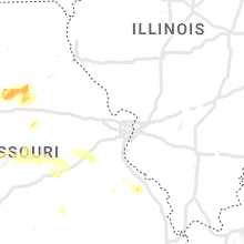
Missouri
| Local Time | Report Details |
|---|---|
| 4:16 PM CDT | Quarter sized hail reported near Butler, MO, 59.9 miles SSE of Kansas City, MO |
| 4:16 PM CDT | Delayed report - some tree limbs dow in bates county MO, 60.4 miles SSE of Kansas City, MO |
| 10:10 PM CDT | Quarter sized hail reported near Maitland, MO, 81 miles NNW of Kansas City, MO |
| 11:13 PM CDT | Limbs down on road in rockport and just outside of rockport on hwy 111. small hail at dispatch cente in atchison county MO, 62.7 miles SSE of Omaha, NE |
| 11:27 PM CDT | Hen Egg sized hail reported near Guilford, MO, 73.6 miles N of Kansas City, MO, report via social media. time estimated via radar. |
| 11:28 PM CDT | Dispatch reported a tree down in mound cit in holt county MO, 78.8 miles NNW of Kansas City, MO |
| 11:41 PM CDT | Hen Egg sized hail reported near Stanberry, MO, 74.4 miles N of Kansas City, MO, sheriffs deputy relayed a public photo of hail estimated at 2 inches south of stanberry. |
| 12:00 AM CDT | Ping Pong Ball sized hail reported near Darlington, MO, 76.3 miles N of Kansas City, MO, report via social media. |
| 1:44 AM CDT | Report of power poles down. also reports of trees and large limbs dow in jackson county MO, 20.7 miles E of Kansas City, MO |
| 1:55 AM CDT | Report of a missing roof in wellington and numerous trees dow in lafayette county MO, 32.5 miles E of Kansas City, MO |
| 2:26 AM CDT | Several large tree limbs down. report via social media. time estimated via rada in johnson county MO, 62.3 miles ESE of Kansas City, MO |
| 3:04 AM CDT | Storm damage reported in pettis county MO, 48.1 miles WSW of Columbia, MO |
| 3:18 AM CDT | Power line reported snapped in front of kwrt radio station. reports of trees down around boonvill in cooper county MO, 21.9 miles W of Columbia, MO |
| 5:09 AM CDT | Several tree limbs down along route 185 north of sullivan. road crews on the way to clean the debri in franklin county MO, 45.9 miles NNE of Salem, MO |
Indiana
| Local Time | Report Details |
|---|---|
| 4:24 PM CDT | Tree down and utility pole knocked down due to strong winds near intersection of folsomville road and ashby roa in warrick county IN, 22.5 miles ENE of Evansville, IN |
Alabama
| Local Time | Report Details |
|---|---|
| 4:56 PM CDT | Ping Pong Ball sized hail reported near Gadsden, AL, 60.9 miles ENE of Birmingham, AL |
| 5:02 PM CDT | Half Dollar sized hail reported near Owens Cross Roads, AL, 68.7 miles E of Florence, AL, half dollar hail in owens crossroads. |
| 5:05 PM CDT | Ping Pong Ball sized hail reported near Brownsboro, AL, 68.5 miles E of Florence, AL, ping pong ball hail in the hampton cove area of se huntsville. |
| 5:05 PM CDT | Several trees down across green mountain along shawdee road. a home in the inspiration subdivision had severe damage due to fallen tree in madison county AL, 67.5 miles E of Florence, AL |
| 5:06 PM CDT | Quarter sized hail reported near Owens Cross Roads, AL, 68.7 miles E of Florence, AL, quarter size hail measured at tailgaters restaurant in hampton cove. |
| 5:09 PM CDT | Several power lines down due to strong thunderstorm winds on green mountain in south huntsvill in madison county AL, 66.9 miles E of Florence, AL |
| 5:11 PM CDT | Quarter sized hail reported near Gadsden, AL, 59.1 miles ENE of Birmingham, AL |
| 5:24 PM CDT | Quarter sized hail reported near Gadsden, AL, 58.8 miles ENE of Birmingham, AL |
| 6:25 PM CDT | One large tree down blocking the roadway on lonesome bend road. a few other trees down in the area and one was on a vehicl in etowah county AL, 59.5 miles ENE of Birmingham, AL |
| 4:10 AM CDT | Trees reported down throughout the city of homewood. some large. via social medi in jefferson county AL, 3.5 miles S of Birmingham, AL |
| 4:30 AM CDT | Tree down on mt. olive road. via social medi in jefferson county AL, 10.4 miles N of Birmingham, AL |
Iowa
| Local Time | Report Details |
|---|---|
| 6:17 PM CDT | Delayed report. semi blown over. time estimated from rada in pottawattamie county IA, 33.5 miles ENE of Omaha, NE |
| 6:45 PM CDT | Storm damage reported in cass county IA, 48.3 miles ENE of Omaha, NE |
| 7:29 PM CDT | Quarter sized hail reported near Fontanelle, IA, 53.2 miles WSW of Des Moines, IA |
| 7:33 PM CDT | Roof blown off of machine shed. time estimate in adair county IA, 55.5 miles WSW of Des Moines, IA |
| 7:45 PM CDT | Large tree down on house. time estimate in adair county IA, 49.7 miles WSW of Des Moines, IA |
| 7:48 PM CDT | Quarter sized hail reported near Orient, IA, 52.4 miles WSW of Des Moines, IA, nickel to quarter sized hail. |
| 7:53 PM CDT | Report from mping: trees uprooted or snapped; roof blown of in union county IA, 53.5 miles SW of Des Moines, IA |
| 7:54 PM CDT | Farm outbuildings damaged on cherry street rd. time estimate in union county IA, 52.3 miles SW of Des Moines, IA |
| 8:00 PM CDT | Reported at 8 pm and 805 p in union county IA, 54.7 miles SW of Des Moines, IA |
| 8:00 PM CDT | Trees... sheds... and power lines dow in union county IA, 53.3 miles SW of Des Moines, IA |
| 8:15 PM CDT | Quarter sized hail reported near Council Bluffs, IA, 4.7 miles E of Omaha, NE |
| 8:24 PM CDT | Ping Pong Ball sized hail reported near Council Bluffs, IA, 8.1 miles ESE of Omaha, NE, mping report. |
| 8:27 PM CDT | Tin blown off of outbuilding on r15. time estimate in clarke county IA, 51.1 miles SSW of Des Moines, IA |
| 9:46 PM CDT | 1 ft tree limb down. time estimated from rada in page county IA, 52.6 miles SE of Omaha, NE |
Kansas
| Local Time | Report Details |
|---|---|
| 6:25 PM MDT | Golf Ball sized hail reported near Weskan, KS, 55.7 miles WSW of Colby, KS, caller reported pea to golf ball sized hail that lasted 13 minutes. |
| 7:10 PM MDT | Hen Egg sized hail reported near Sharon Springs, KS, 51.1 miles SW of Colby, KS, spotter reported golf-ball to egg size hail that had just started. |
| 8:30 PM CDT | Quarter sized hail reported near Herndon, KS, 38.1 miles NNE of Colby, KS, reported via social media. |
| 8:31 PM CDT | Storm damage reported in morton county KS, 86.3 miles SW of Garden City, KS |
| 8:35 PM CDT | Half Dollar sized hail reported near Oberlin, KS, 47.8 miles NNE of Colby, KS, reported via social media. large amounts of hail damaged one inch tall triticale... wheat... milo... and oat fields. |
| 8:47 PM CDT | Golf Ball sized hail reported near Herndon, KS, 37.9 miles NNE of Colby, KS |
| 8:48 PM CDT | Reported via social media. estimated 50 to 60 mph wind in decatur county KS, 43.2 miles NE of Colby, KS |
| 8:48 PM CDT | Golf Ball sized hail reported near Oberlin, KS, 43.7 miles NE of Colby, KS |
| 8:50 PM CDT | Ping Pong Ball sized hail reported near Oberlin, KS, 40.6 miles NE of Colby, KS, spotter reported ping pong ball sized hail that caused damage to gutters. |
| 8:50 PM CDT | Tennis Ball sized hail reported near Oberlin, KS, 40.1 miles NE of Colby, KS, reported via social media. damage to cars... siding due to hail. large tree limbs also downed by the hail. |
| 8:50 PM CDT | Quarter sized hail reported near Atwood, KS, 28.5 miles N of Colby, KS, nickel to quarter size hail. |
| 8:55 PM CDT | Half Dollar sized hail reported near Oberlin, KS, 40.1 miles NE of Colby, KS, spotter reported hail broke 3 windows in the home. |
| 8:55 PM CDT | Kansas mesonet observation. gust was at 10 meter height. a 65 mph gust was reported at the same time at 2 meter heigh in decatur county KS, 47.4 miles NE of Colby, KS |
| 9:00 PM CDT | Baseball sized hail reported near Oberlin, KS, 39.7 miles NE of Colby, KS, reported via social media with wind shields damaged. numerous reports of broken windows in homes and cars around the city. |
| 9:12 PM CDT | Golf Ball sized hail reported near Jennings, KS, 44.8 miles ENE of Colby, KS, reported via social media. |
| 9:12 PM CDT | Ping Pong Ball sized hail reported near Jennings, KS, 44.8 miles ENE of Colby, KS, reported via social media. quarter to ping pong ball sized hail reported in jennings. |
| 9:15 PM CDT | Tennis Ball sized hail reported near Jennings, KS, 45.7 miles ENE of Colby, KS, caller reported ongoing hail up to tennis ball in size accumulating on the ground. |
| 9:15 PM CDT | Quarter sized hail reported near Clayton, KS, 52.8 miles ENE of Colby, KS, caller reported dime to quarter sized hail that lasted about 15 minutes in duration. |
| 9:35 PM CDT | Mesonet station k36k kearny county airpor in kearny county KS, 21.1 miles W of Garden City, KS |
| 9:48 PM CDT | Ping Pong Ball sized hail reported near Manter, KS, 66.8 miles WSW of Garden City, KS |
| 10:00 PM CDT | Ping Pong Ball sized hail reported near Elkhart, KS, 87.5 miles SW of Garden City, KS |
| 10:00 PM CDT | Hen Egg sized hail reported near Elkhart, KS, 87.5 miles SW of Garden City, KS, fm social media post. |
| 10:08 PM CDT | Report from mping: 3-inch tree limbs broken; power poles broke in republic county KS, 75.1 miles SSE of Grand Island, NE |
| 10:25 PM CDT | Storm damage reported in jewell county KS, 84.1 miles NE of Hays, KS |
| 10:31 PM CDT | Corrects previous non-tstm wnd gst report from 2 sse concordia. asos station kcnk concordi in cloud county KS, 63.7 miles WNW of Manhattan, KS |
| 10:31 PM CDT | Delayed report. several 3 inch tree limbs down and damage to outbuilding in washington county KS, 56 miles NW of Manhattan, KS |
| 10:40 PM CDT | Storm damage reported in washington county KS, 46.7 miles NW of Manhattan, KS |
| 10:56 PM CDT | Via raws mesonet. peak gust over the previous 60 minute in phillips county KS, 55.6 miles N of Hays, KS |
| 11:00 PM CDT | Storm damage reported in marshall county KS, 36.1 miles NNW of Manhattan, KS |
| 11:09 PM CDT | Numerous trees and power lines dow in marshall county KS, 35 miles N of Manhattan, KS |
| 11:39 PM CDT | Delayed report. social media repor in nemaha county KS, 52.9 miles NNE of Manhattan, KS |
| 11:42 PM CDT | Storm damage reported in nemaha county KS, 43.7 miles NE of Manhattan, KS |
| 11:43 PM CDT | Storm damage reported in nemaha county KS, 43.7 miles NE of Manhattan, KS |
| 12:16 AM CDT | Storm damage reported in shawnee county KS, 42.4 miles ESE of Manhattan, KS |
| 12:33 AM CDT | Storm damage reported in shawnee county KS, 50.5 miles ESE of Manhattan, KS |
| 1:10 AM CDT | Possible carport or awning heavily damaged and lots of tree damage at the wind river lodge apartment complex. report via social media. time estimated via rada in johnson county KS, 14.1 miles SW of Kansas City, MO |
| 1:18 AM CDT | Large tree down between 95th and 97th on kessle in johnson county KS, 11.4 miles SSW of Kansas City, MO |
| 1:20 AM CDT | Numerous trees and powerlines down in the ne portion of joco... focusing on the 95th street corridor. no reports of any widespread structural damage. time estimate via in johnson county KS, 11.4 miles SSW of Kansas City, MO |
| 3:15 AM CDT | Peak gust measured from home weather station. time estimated by radar dat in morton county KS, 86.8 miles SW of Garden City, KS |
| 3:35 AM CDT | Awos station keha elkhart awos sit in morton county KS, 87.5 miles SW of Garden City, KS |
New Mexico
| Local Time | Report Details |
|---|---|
| 6:30 PM MDT | Quarter sized hail reported near Mosquero, NM, 43.5 miles NNW of Tucumcari, NM, nickel to quarter size hail. |
| 6:56 PM MDT | Quarter sized hail reported near Roy, NM, 59.5 miles NNW of Tucumcari, NM |
| 6:59 PM MDT | Quarter sized hail reported near Solano, NM, 42.2 miles NNW of Tucumcari, NM, largest hail quarter size. |
| 7:03 PM MDT | Baseball sized hail reported near , , 28.4 miles NNW of Tucumcari, NM, three double paned plexiglass skylights broken. auto windshields also busted. spotter said they were the largest hailstones he has seen in the last 50 years. |
| 8:00 PM MDT | Quarter sized hail reported near Logan, NM, 19.1 miles NE of Tucumcari, NM, mostly nickel size... but a few quarter size hailstones. |
| 8:13 PM MDT | Report from ktcc aso in quay county NM, 6.5 miles E of Tucumcari, NM |
Texas
| Local Time | Report Details |
|---|---|
| 8:14 PM CDT | Storm damage reported in hartley county TX, 69.6 miles NW of Amarillo, TX |
| 11:19 PM CDT | Golf Ball sized hail reported near Farnsworth, TX, 87.9 miles W of Woodward, OK |
| 12:06 AM CDT | Hen Egg sized hail reported near Perryton, TX, 81 miles WSW of Woodward, OK, hail ranging from nickel size up to around the size of an egg. |
| 1:03 AM CDT | Quarter sized hail reported near Canadian, TX, 65.7 miles WSW of Woodward, OK, deputy reported nickel to quarter sized hail fell in town for about 6 minutes. hail started at 1:03 am. |
| 1:08 AM CDT | Quarter sized hail reported near Canadian, TX, 66.5 miles WSW of Woodward, OK, report with picture from social media. hail fell for about 3 minutes. |
| 5:12 AM CDT | West texas mesonet station palo duro reservoir 1nw. 58 mph or greater gusts occurred from 505 am to 514 am cdt with the peak gust at 51 in hansford county TX, 87.6 miles NNE of Amarillo, TX |
| 5:25 AM CDT | Awos station ke42 major samuel b cornelius field spearman. peak gust reported in 535 am metar without peak wind remarks. thus... exact time in the preceding 10 minute w in hansford county TX, 78.6 miles NNE of Amarillo, TX |
| 5:28 AM CDT | Report from mping: 3-inch tree limbs broken; power poles broke in hansford county TX, 76.6 miles NNE of Amarillo, TX |
| 5:55 AM CDT | Awos station kdux dumas (awos in moore county TX, 45.5 miles NNW of Amarillo, TX |
| 6:00 AM CDT | West texas mesonet 8 w lipscomb. 58 mph or greater gusts occurred from 559 to 601 am cd in lipscomb county TX, 58.3 miles WSW of Woodward, OK |
| 6:00 AM CDT | West texas mesonet station stinnett 1nnw. 58 mph or greater gusts occurred between 551 and 611 am cd in hutchinson county TX, 48.7 miles NNE of Amarillo, TX |
| 6:03 AM CDT | West texas mesonet site dumas 3 se. 58 mph or greater gusts occurred from 551 through 611 am cd in moore county TX, 43.2 miles N of Amarillo, TX |
| 6:15 AM CDT | Awos station kbpc mesa vista ranch (awos in roberts county TX, 64.8 miles NE of Amarillo, TX |
| 6:28 AM CDT | West texas mesonet station fritch 1wn in moore county TX, 32.8 miles NNE of Amarillo, TX |
| 6:32 AM CDT | West texas mesonet site 10 e miami. 58 mph or greater gusts occurred from 631 to 634 am cd in hemphill county TX, 77.6 miles SW of Woodward, OK |
Connect with Interactive Hail Maps