

Hail Map for Monday, May 23, 2022

Number of Impacted Households on 5/23/2022
0
Impacted by 1" or Larger Hail
0
Impacted by 1.75" or Larger Hail
0
Impacted by 2.5" or Larger Hail
Square Miles of Populated Area Impacted on 5/23/2022
0
Impacted by 1" or Larger Hail
0
Impacted by 1.75" or Larger Hail
0
Impacted by 2.5" or Larger Hail


Cities Most Affected by Hail Storms of 5/23/2022
| Hail Size | Demographics of Zip Codes Affected | ||||||
|---|---|---|---|---|---|---|---|
| City | Count | Average | Largest | Pop Density | House Value | Income | Age |
| Bovina, TX | 1 | 2.50 | 2.50 | 3 | $32k | $26.9k | 28.9 |
| Sudan, TX | 1 | 2.25 | 2.25 | 3 | $34k | $32.3k | 37.8 |
| Levelland, TX | 1 | 1.75 | 1.75 | 39 | $54k | $30.6k | 32.5 |
| Rogers, NM | 1 | 1.75 | 1.75 | 1 | $75k | $23.8k | 46.6 |
Hail and Wind Damage Spotted on 5/23/2022
Filter by Report Type:Hail ReportsWind Reports
Georgia
| Local Time | Report Details |
|---|---|
| 10:49 AM EDT | Corrects previous tstm wnd dmg report from appling. sheriff dispatch reported a power line down just south of the intersection of ray owens road and white oak roa in columbia county GA, 20.5 miles WNW of Augusta, GA |
| 11:05 AM EDT | Sheriff dispatch reported a tree down at the intersection of pepperidge drive and peach orchard roa in richmond county GA, 7.5 miles SSW of Augusta, GA |
| 4:11 PM EDT | Tree down near the intersection of ga-46 and fifteen mile creek road. time estimated by rada in candler county GA, 58.4 miles WNW of Savannah, GA |
| 4:13 PM EDT | A few trees down near the intersection fo harrison-davisboro rd and brown circle in washington county GA, 53.1 miles WSW of Augusta, GA |
| 4:13 PM EDT | A few trees down near the intersection fo harrison-davisboro rd and brown circle in washington county GA, 51.3 miles SW of Augusta, GA |
| 4:14 PM EDT | Tree down over shiloh rd near the intersection with hwy 44 in clinch county GA, 35.3 miles SSE of Douglas, GA |
| 4:18 PM EDT | Tree down across shiloh rd 3 miles east of hwy 44 in clinch county GA, 35.9 miles SSE of Douglas, GA |
| 4:19 PM EDT | Candler county sheriff's office relayed images of numerous trees with some power poles down along rosemary church road. damage is consistent with straight line winds. t in candler county GA, 57.9 miles WNW of Savannah, GA |
| 4:19 PM EDT | Tree down near the intersection of portal highway and rosemary church road. time estimated by rada in candler county GA, 59.6 miles WNW of Savannah, GA |
| 4:22 PM EDT | Tree down near the intersection of rosemary church road and lawrence road. time estimated by rada in candler county GA, 58.5 miles WNW of Savannah, GA |
| 4:56 PM EDT | Tree down near the intersection of metter road and brack road. time estimated by rada in bulloch county GA, 58.7 miles WNW of Savannah, GA |
| 5:02 PM EDT | Two trees down near the intersection of stoney hill road and romie waters highway. time estimated by rada in tattnall county GA, 53.7 miles W of Savannah, GA |
| 5:14 PM EDT | Tree down near the intersection of old register way and bohler rimes roa in bulloch county GA, 47.1 miles WNW of Savannah, GA |
| 5:32 PM EDT | Tree down on a house along warnell street in pembroke. time estimated based on rada in bryan county GA, 31.3 miles W of Savannah, GA |
| 5:35 PM EDT | Tree down near the intersection of highway 19 and george edwards road. time estimated based on rada in bryan county GA, 30.5 miles WNW of Savannah, GA |
South Carolina
| Local Time | Report Details |
|---|---|
| 11:01 AM EDT | Sheriff dispatch reported a tree down at the intersection of woodward lake road and mount zion roa in edgefield county SC, 12.1 miles NNE of Augusta, GA |
| 11:26 AM EDT | Sheriff dispatch reported a tree fell on a vehicle near the intersection of shiloh heights road and pipeline road. no injuries reporte in aiken county SC, 16.9 miles ENE of Augusta, GA |
| 11:48 AM EDT | Highway patrol reported a tree down near the intersection of macedonia church road and stockman roa in newberry county SC, 54 miles NNE of Augusta, GA |
| 11:52 AM EDT | 1 tree reported down as the storm came throug in union county SC, 56 miles SW of Charlotte, NC |
| 11:58 AM EDT | Highway patrol reported a tree down near the intersection of hwy. 176 and parr roa in newberry county SC, 62.9 miles NNE of Augusta, GA |
| 12:00 PM EDT | 3 trees down on first stree in union county SC, 46.2 miles SW of Charlotte, NC |
| 2:49 PM EDT | Sheriff dispatch reported trees down on a powerline along hummingbird road near great circle driv in calhoun county SC, 62.9 miles NW of Charleston, SC |
| 5:44 PM EDT | Sheriff dispatch reported a large tree down along state park road near aiken state par in aiken county SC, 28.4 miles E of Augusta, GA |
| 5:47 PM EDT | Highway patrol reported a tree down in the roadway and blocked at hwy. 176 and new hope road near pomari in newberry county SC, 63.2 miles NNE of Augusta, GA |
| 5:55 PM EDT | Tree down near the intersection of shirley road and augusta stagecoach road. time estimated based on rada in hampton county SC, 42.1 miles NNW of Savannah, GA |
| 6:03 PM EDT | Tree down near the intersection of honey hill road and steep bottom road. time estimated based on rada in hampton county SC, 42.5 miles N of Savannah, GA |
| 6:05 PM EDT | Tree down near the intersetion of tye branch road and richard pollins road. time estimated based on rada in jasper county SC, 37.5 miles N of Savannah, GA |
| 6:10 PM EDT | Sc dot reported several trees down in the area of clear pond rd... orange grove rd... and ehrhardt rd. time estimate in bamberg county SC, 56.6 miles ESE of Augusta, GA |
| 6:12 PM EDT | Tree down near the intersection of sc-3 and johnie peeples dr. time estimated based on rada in jasper county SC, 42.7 miles N of Savannah, GA |
| 6:14 PM EDT | Broadcast media reported large tree down on power lines on the intersection of sandy ford and paris bridge roa in spartanburg county SC, 43.1 miles ENE of Greenville, SC |
| 6:15 PM EDT | Trees blocking two lanes of browninggate road between chocolate city road and two sisters road. time estimated based on rada in hampton county SC, 46.9 miles N of Savannah, GA |
| 6:21 PM EDT | Tree down near the intersection of grays highway and gillison branch road. time estimated based on rada in jasper county SC, 36.8 miles N of Savannah, GA |
| 6:33 PM EDT | Tree down near the intersecton of red root road and deliverance road. time estimated based on rada in colleton county SC, 49.6 miles WSW of Charleston, SC |
| 6:33 PM EDT | Tree down near the intersection of sc-63 and us-21. time estimated based on rada in colleton county SC, 53 miles WSW of Charleston, SC |
| 6:33 PM EDT | Trees down near the intersection of lowcountry highway and school house road. time estimated based on rada in colleton county SC, 53.3 miles WSW of Charleston, SC |
| 6:35 PM EDT | Trees down along i-95 near exit 4 in colleton county SC, 48.6 miles NNE of Savannah, GA |
| 6:40 PM EDT | 911 call center reported several trees down on dewitt and golf course roa in chester county SC, 45.6 miles S of Charlotte, NC |
| 6:41 PM EDT | Tree down near the intersection of benton farm road and hudson mill road. time estimated based on rada in colleton county SC, 47.7 miles WSW of Charleston, SC |
| 6:45 PM EDT | Highway patrol reported a tree in the roadway near the intersection of hwy. 78... north road... and kennerly roa in orangeburg county SC, 57 miles WNW of Charleston, SC |
| 6:45 PM EDT | 911 call center reported trees and powerlines dow in chester county SC, 43.9 miles S of Charlotte, NC |
| 6:45 PM EDT | 911 call center reported trees down on catawba river rd in chester county SC, 43 miles S of Charlotte, NC |
| 6:55 PM EDT | Dorcheser county 911 dispatch reported a tree was blown down across quaker road in saint george. a motorist had a collision with the tree as it fell. the driver was not in dorchester county SC, 32.9 miles W of Charleston, SC |
| 7:14 PM EDT | Corrects previous tstm wnd dmg report from 3 w mayo. broadcast media reported large tree down on power lines on the intersection of sandy ford and paris bridge roa in spartanburg county SC, 43.1 miles ENE of Greenville, SC |
| 7:15 PM EDT | Broadcast media reported several large trees down including one on a house. half dozen buildings destroyed... one house with roof blown of in spartanburg county SC, 42.5 miles ENE of Greenville, SC |
| 7:54 PM EDT | Tree down near the intersection of harristown road and mendel rivers road. time estimated based on rada in berkeley county SC, 14.6 miles NNE of Charleston, SC |
Maryland
| Local Time | Report Details |
|---|---|
| 12:21 PM EDT | Several tree branches down along east franklin ave in montgomery county MD, 28.5 miles SW of Baltimore, MD |
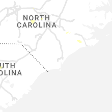
North Carolina
| Local Time | Report Details |
|---|---|
| 1:20 PM EDT | Trees and power lines down along burnt umber drive. possible tornad in mecklenburg county NC, 7.5 miles ENE of Charlotte, NC |
| 1:37 PM EDT | Trained spotter reported trees snapped and uprooted on hood r in mecklenburg county NC, 9 miles ENE of Charlotte, NC |
| 1:43 PM EDT | Trees down near piccadilly lane. possible tornad in cabarrus county NC, 10.9 miles ENE of Charlotte, NC |
| 1:48 PM EDT | Trees and power lines down on rocky river road. possible tornad in cabarrus county NC, 12.1 miles ENE of Charlotte, NC |
| 1:52 PM EDT | Broadcast media reported large tree limbs down and a truck tipped over by possible tornado on mulberry rd in cabarrus county NC, 14.8 miles ENE of Charlotte, NC |
| 1:55 PM EDT | Stanly county 911 reports numerous trees down county-wid in stanly county NC, 33.8 miles ENE of Charlotte, NC |
| 2:30 PM EDT | Tree down on okeewemee rd near nc highway 134-n in tro in montgomery county NC, 55.2 miles ENE of Charlotte, NC |
| 2:45 PM EDT | Trees blown down. time estimated by rada in randolph county NC, 64.7 miles ENE of Charlotte, NC |
| 2:50 PM EDT | Trees uprooted or snapped; roof blown off. time estimated by rada in randolph county NC, 58.2 miles ENE of Charlotte, NC |
| 2:53 PM EDT | Two trees blown down along with large limbs near the intersection of jackson creek rd and parker mill rd near marth in randolph county NC, 57.7 miles ENE of Charlotte, NC |
| 2:55 PM EDT | Tree down on house on e lindale dr in robbins. multiple other trees down in the robbins are in moore county NC, 58.2 miles WSW of Raleigh, NC |
| 3:25 PM EDT | Trees and power lines down on deep river roa in lee county NC, 31.6 miles WSW of Raleigh, NC |
| 3:29 PM EDT | Tree blown down at the intersection of mciver st and 7th street in sanfor in lee county NC, 36.4 miles SW of Raleigh, NC |
| 3:32 PM EDT | Tree blown down near the intersection of carthage st and carbonton rd. time estimated by rada in lee county NC, 37.3 miles SW of Raleigh, NC |
| 3:34 PM EDT | Tree down at efland-cedar grove rd and us highway 70 in orange county NC, 35.9 miles NW of Raleigh, NC |
| 3:40 PM EDT | Tree down at nc highway 54 w and stanford r in orange county NC, 35.2 miles WNW of Raleigh, NC |
| 3:46 PM EDT | Downed trees on power equipment and line in chatham county NC, 24.6 miles SW of Raleigh, NC |
| 4:04 PM EDT | Numerous trees snapped along highway 70 near laurel d in durham county NC, 16.3 miles NW of Raleigh, NC |
| 4:05 PM EDT | Trees down in northgate park neighborhood north of downtown durham. time estimated by rada in durham county NC, 21.7 miles NW of Raleigh, NC |
| 4:10 PM EDT | Numerous trees down throughout the county... including downed trees on home in durham county NC, 22.9 miles NW of Raleigh, NC |
| 4:14 PM EDT | Trees down on power line in johnston county NC, 14.8 miles ESE of Raleigh, NC |
| 4:16 PM EDT | Fallen trees on power equipmen in wake county NC, 13.3 miles NNW of Raleigh, NC |
| 4:23 PM EDT | Tree down on power lin in johnston county NC, 15.5 miles ESE of Raleigh, NC |
| 4:45 PM EDT | Numerous trees and power-lines down throughout the count in franklin county NC, 30.3 miles NE of Raleigh, NC |
| 5:10 PM EDT | Damage to an out building smith grady roa in lenoir county NC, 65.5 miles N of Wilmington, NC |
| 5:22 PM EDT | Public reports power pole snapped along bland howell rd. time based on rada in lenoir county NC, 66.4 miles N of Wilmington, NC |
| 5:22 PM EDT | Law enforcement relayed report of damage to a structure along hwy 55 near moss hill. time based on rada in lenoir county NC, 64.5 miles SE of Raleigh, NC |
| 5:24 PM EDT | Quarter sized hail reported near Kinston, NC, 66.6 miles NNE of Wilmington, NC, public reported at least quarter size hail lasting for about 15 minutes. time based on radar. |
| 5:33 PM EDT | Quarter sized hail reported near Kinston, NC, 70.1 miles NNE of Wilmington, NC, public reported nickel to quarter sized hail. time based on radar. |
| 6:05 PM EDT | Craven county 911 relayed report of trees down near the intersection of camelot dr. and north ridge rd. in james city. time based on rada in craven county NC, 78.3 miles NE of Wilmington, NC |
| 7:25 PM EDT | Broadcast media reported trees down and damage to hous in union county NC, 28.5 miles SE of Charlotte, NC |
Florida
| Local Time | Report Details |
|---|---|
| 2:02 PM CDT | Tree down along hwy 231 south of alfor in jackson county FL, 61.4 miles ENE of Miramar Beach, FL |
| 2:05 PM CDT | Trees on powerline in alford at park rd and arizona stree in jackson county FL, 61.5 miles ENE of Miramar Beach, FL |
| 2:20 PM CDT | Trees down near hwy 73 and hasty pond r in jackson county FL, 54.6 miles W of Tallahassee, FL |
| 2:20 PM CDT | Tree down near u.s. hwy 9 in jackson county FL, 61.8 miles WNW of Tallahassee, FL |
| 2:40 PM CDT | Tree down along hwy 6 in calhoun county FL, 45.3 miles W of Tallahassee, FL |
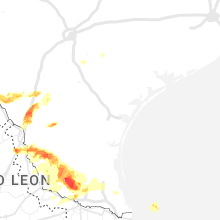
Texas
| Local Time | Report Details |
|---|---|
| 4:53 PM CDT | Quarter sized hail reported near Hartley, TX, 60.7 miles NNW of Amarillo, TX |
| 5:00 PM CDT | Ping Pong Ball sized hail reported near Dalhart, TX, 63 miles NNW of Amarillo, TX |
| 5:45 PM CDT | Golf Ball sized hail reported near , , 68.7 miles WNW of Lubbock, TX |
| 6:17 PM CDT | Ping Pong Ball sized hail reported near Maple, TX, 61.4 miles WNW of Lubbock, TX |
| 6:33 PM CDT | Quarter sized hail reported near Bovina, TX, 65.7 miles SE of Tucumcari, NM |
| 6:36 PM CDT | Hen Egg sized hail reported near Sudan, TX, 63.5 miles WNW of Lubbock, TX |
| 6:50 PM CDT | Tennis Ball sized hail reported near Bovina, TX, 68.1 miles SE of Tucumcari, NM |
| 7:47 PM CDT | West texas mesonet. 40 mph sustained winds also observe in cochran county TX, 51.8 miles W of Lubbock, TX |
| 8:20 PM CDT | Quarter sized hail reported near Zapata, TX, 46.6 miles SSE of Laredo, TX, fire department employee reports estimated quarter size hail. |
| 8:34 PM CDT | Quarter sized hail reported near , , 23.5 miles NNE of Laredo, TX, quarter size hail at mile marker 26 along i-35. |
| 8:38 PM CDT | West texas mesone in cochran county TX, 51.8 miles W of Lubbock, TX |
| 9:05 PM CDT | Ping Pong Ball sized hail reported near Encinal, TX, 36.1 miles NNE of Laredo, TX, ping pong ball sized hail reported southeast of encinal. |
| 9:28 PM CDT | Golf Ball sized hail reported near Levelland, TX, 27.9 miles W of Lubbock, TX |
| 9:49 PM CDT | Quarter sized hail reported near Shallowater, TX, 13.6 miles WNW of Lubbock, TX |
| 9:51 PM CDT | Power poles blown down at the intersection of fm 597 and fm 30 in hockley county TX, 42.8 miles WNW of Lubbock, TX |
| 9:53 PM CDT | Power poles snappe in hockley county TX, 38.9 miles W of Lubbock, TX |
| 9:59 PM CDT | Quarter sized hail reported near Smyer, TX, 20.7 miles WNW of Lubbock, TX, 2 to 3 inches of accumulated quarter-sized hail on the ground. |
| 10:05 PM CDT | West texas mesonet in bailey county TX, 66.3 miles NW of Lubbock, TX |
| 10:42 PM CDT | Barn damaged in hockley county TX, 39.5 miles W of Lubbock, TX |
| 11:14 PM CDT | Lamb county sheriff's office reported power lines down on county road 167. time estimated from rada in lamb county TX, 51 miles NW of Lubbock, TX |
| 12:42 AM CDT | West texas mesonet in hale county TX, 20.6 miles NNE of Lubbock, TX |
| 3:26 AM CDT | Storm damage reported in childress county TX, 3.9 miles W of Childress, TX |
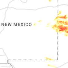
New Mexico
| Local Time | Report Details |
|---|---|
| 4:10 PM MDT | Quarter sized hail reported near Clovis, NM, 58.6 miles SSE of Tucumcari, NM, covering ground... marbles up to quarter in size. |
| 4:15 PM MDT | Quarter sized hail reported near Clovis, NM, 60.8 miles SSE of Tucumcari, NM, 1" hail for 5 minutes from 4:15 to 4:20. |
| 4:25 PM MDT | Quarter sized hail reported near Clovis, NM, 60.2 miles SSE of Tucumcari, NM, hail covered the ground. |
| 4:39 PM MDT | Quarter sized hail reported near Rogers, NM, 78.8 miles WNW of Lubbock, TX, report from mping: quarter (1.00 in.). |
| 4:41 PM MDT | Golf Ball sized hail reported near Rogers, NM, 79.9 miles WNW of Lubbock, TX, report from mping: golf ball (1.75 in.). |
| 4:54 PM MDT | Quarter sized hail reported near Texico, NM, 57.3 miles SE of Tucumcari, NM, from brandon at fire and rescue. |
| 5:18 PM MDT | Quarter sized hail reported near Clayton, NM, 92.8 miles NNE of Tucumcari, NM, video of estimated quarter size hail in clayton via twitter. |
Connect with Interactive Hail Maps