

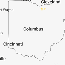
Hail Map for Saturday, May 26, 2018

Number of Impacted Households on 5/26/2018
0
Impacted by 1" or Larger Hail
0
Impacted by 1.75" or Larger Hail
0
Impacted by 2.5" or Larger Hail
Square Miles of Populated Area Impacted on 5/26/2018
0
Impacted by 1" or Larger Hail
0
Impacted by 1.75" or Larger Hail
0
Impacted by 2.5" or Larger Hail


Cities Most Affected by Hail Storms of 5/26/2018
| Hail Size | Demographics of Zip Codes Affected | ||||||
|---|---|---|---|---|---|---|---|
| City | Count | Average | Largest | Pop Density | House Value | Income | Age |
| Circle, MT | 1 | 2.00 | 2.00 | 0 | $43k | $28.5k | 47.1 |
| Perronville, MI | 1 | 2.00 | 2.00 | 1 | $38k | $40.9k | 46.5 |
| Wilson, MI | 1 | 1.75 | 1.75 | 30 | $69k | $30.9k | 35.1 |
| La Grange, MO | 1 | 1.75 | 1.75 | 25 | $51k | $31.7k | 43.2 |
| Richey, MT | 1 | 1.75 | 1.75 | 0 | $21k | $27.5k | 49.7 |
| Beaumont, TX | 1 | 1.75 | 1.75 | 2648 | $98k | $49.6k | 39.9 |
| Woodville, TX | 1 | 1.75 | 1.75 | 30 | $53k | $28.7k | 39.7 |
| Brockway, MT | 1 | 1.75 | 1.75 | 0 | $31k | $23.4k | 42.5 |
Hail and Wind Damage Spotted on 5/26/2018
Filter by Report Type:Hail ReportsWind Reports
States Impacted
Michigan, Louisiana, Ohio, Virginia, Mississippi, Missouri, Illinois, Idaho, Texas, New Jersey, Montana, Wisconsin, Wyoming, North DakotaMichigan
| Local Time | Report Details |
|---|---|
| 12:29 PM EDT | Quarter sized hail reported near Negaunee, MI, 6.5 miles W of Marquette, MI, observed quarter sized hail at wfo marquette in negaunee township. heavy rain also observed. |
| 12:30 PM EDT | Quarter sized hail reported near Negaunee, MI, 10.4 miles W of Marquette, MI, observed quarter sized hail just to the south of the dead river basin north of negaunee. report via social media. delayed report. |
| 12:33 PM EDT | Quarter sized hail reported near Negaunee, MI, 9.7 miles WSW of Marquette, MI, quarter sized hail was observed a few blocks just to the north of downtown negaunee. |
| 3:49 PM EDT | Quarter sized hail reported near Lanse, MI, 46.2 miles W of Marquette, MI, pea size hail also reported at 337 pm edt. |
| 3:10 PM CDT | Quarter sized hail reported near Bark River, MI, 41.4 miles SSW of Marquette, MI, sporadic nickel and quarter size hail near stromberg park. |
| 3:10 PM CDT | Hen Egg sized hail reported near Perronville, MI, 43 miles SSW of Marquette, MI, delayed report: location is in helps... mi. |
| 4:11 PM EDT | Quarter sized hail reported near Lake City, MI, 40.4 miles SE of Traverse City, MI, delayed hail report from yesterday. |
| 4:30 PM EDT | Large tree down on a home on townline road. time estimated from rada in oscoda county MI, 42.1 miles WSW of Alpena, MI |
| 4:53 PM EDT | Quarter sized hail reported near Lachine, MI, 16 miles WSW of Alpena, MI |
| 3:55 PM CDT | Golf Ball sized hail reported near Wilson, MI, 57.7 miles S of Marquette, MI, hail fell for 8 minutes... ranging in size from 1" to 1.75" in diameter. |
| 5:02 PM EDT | Quarter sized hail reported near Republic, MI, 28.6 miles WSW of Marquette, MI, hail up to quarter size reported in republic. |
| 5:08 PM EDT | Quarter sized hail reported near Gaylord, MI, 45.2 miles ENE of Traverse City, MI |
| 4:13 PM CDT | Quarter sized hail reported near Hermansville, MI, 58.4 miles S of Marquette, MI, one inch diameter hail reported by public. |
| 4:21 PM CDT | Quarter sized hail reported near Spalding, MI, 58.6 miles S of Marquette, MI |
| 5:41 PM EDT | Quarter sized hail reported near Gaylord, MI, 51.2 miles ENE of Traverse City, MI |
| 6:00 PM EDT | Quarter sized hail reported near Gladwin, MI, 69.5 miles SE of Traverse City, MI |
| 8:27 PM EDT | Large tree down over the road near e sugnet rd and swede ave in midland. additional report of numerous trees down throughout the cit in midland county MI, 50.2 miles NNW of Flint, MI |
| 8:38 PM EDT | Storm damage reported in saginaw county MI, 44.5 miles NW of Flint, MI |
| 8:55 PM EDT | Small branches dow in saginaw county MI, 41.4 miles NNW of Flint, MI |
| 9:15 PM EDT | Saginaw county central dispatch reported numerous trees down across the county... particularly in thomas townshi in saginaw county MI, 33.9 miles NW of Flint, MI |
Louisiana
| Local Time | Report Details |
|---|---|
| 12:57 PM CDT | Spotter reported 59 mph wind gust and tree limbs down north of jenning in jefferson davis county LA, 40.7 miles W of Lafayette, LA |
| 3:17 PM CDT | Quarter sized hail reported near Rayville, LA, 33 miles S of Bastrop, LA |
| 5:05 PM CDT | Tree down across hwy 56 in concordia county LA, 80.5 miles SSE of Bastrop, LA |
Ohio
| Local Time | Report Details |
|---|---|
| 3:04 PM EDT | Tree down across elliott hill r in scioto county OH, 73.5 miles WNW of Charleston, WV |
| 4:12 PM EDT | Tree fell on deck and house. time estimated via rada in hamilton county OH, 4.1 miles W of Cincinnati, OH |
| 4:18 PM EDT | Tree down and wires over roadway. time estimated via rada in hamilton county OH, 3.1 miles NNW of Cincinnati, OH |
| 4:30 PM EDT | Several trees and power lines down in clermont county OH, 16.1 miles ENE of Cincinnati, OH |
| 4:50 PM EDT | Trees and branches dow in clermont county OH, 15.6 miles NE of Cincinnati, OH |
| 7:05 PM EDT | Trees and power lines down and barn-roof damage immediately north of dove in tuscarawas county OH, 68.1 miles S of Cleveland, OH |
Virginia
| Local Time | Report Details |
|---|---|
| 3:30 PM EDT | Trees down on the 4300 block of wardensville grade in frederick county VA, 81.2 miles E of Elkins, WV |
| 5:12 PM EDT | Tree down at intersection of zachary taylor highway and winston station lane in culpeper county VA, 65.5 miles NNW of Richmond, VA |
Mississippi
| Local Time | Report Details |
|---|---|
| 3:46 PM CDT | A few trees down in tow in warren county MS, 41 miles W of Jackson, MS |
| 4:45 PM CDT | Tree down across natchez trace parkway. wind gust estimated at 50 mp in leake county MS, 39 miles NE of Jackson, MS |
| 5:00 PM CDT | Quarter sized hail reported near Columbia, MS, 76.6 miles SSE of Jackson, MS, mostly dime size with a few up to quarter size. |
| 5:35 PM CDT | Quarter sized hail reported near Vaiden, MS, 57.9 miles WSW of Starkville, MS |
Missouri
| Local Time | Report Details |
|---|---|
| 3:55 PM CDT | Quarter sized hail reported near Hale, MO, 71.9 miles ENE of Kansas City, MO |
| 4:03 PM CDT | Half Dollar sized hail reported near Cameron, MO, 47.6 miles NNE of Kansas City, MO |
| 4:44 PM CDT | Quarter sized hail reported near Rushville, MO, 41.3 miles NW of Kansas City, MO |
| 4:57 PM CDT | Half Dollar sized hail reported near Rushville, MO, 40.9 miles NW of Kansas City, MO |
| 5:05 PM CDT | Ping Pong Ball sized hail reported near Rushville, MO, 41.3 miles NW of Kansas City, MO |
| 6:40 PM CDT | Quarter sized hail reported near Monticello, MO, 16 miles S of Kahoka, MO |
| 6:56 PM CDT | Golf Ball sized hail reported near La Grange, MO, 28.7 miles SSE of Kahoka, MO, time estimated by radar. |
| 7:14 PM CDT | Quarter sized hail reported near Maywood, MO, 32.4 miles S of Kahoka, MO |
| 7:49 PM CDT | Quarter sized hail reported near Philadelphia, MO, 40.1 miles S of Kahoka, MO |
| 1:59 AM CDT | Report of a tree down near i-64 and i-17 in st. louis county MO, 7.6 miles W of Saint Louis, MO |
| 2:00 AM CDT | Tree down in clayto in st. louis county MO, 7.2 miles WNW of Saint Louis, MO |
| 2:07 AM CDT | Quarter sized hail reported near Saint Louis, MO, 5.5 miles WSW of Saint Louis, MO, hampton village. |
| 2:07 AM CDT | Ameren reports tree on power line near franz park. time estimated from rada in st. louis city county MO, 6 miles W of Saint Louis, MO |
| 2:16 AM CDT | Quarter sized hail reported near Saint Louis, MO, 6.8 miles WSW of Saint Louis, MO, twitter report of quarter size hail. |
| 2:17 AM CDT | Quarter sized hail reported near Saint Louis, MO, 4.3 miles WSW of Saint Louis, MO, quarter size hail cracked a window pane. |
| 2:24 AM CDT | Quarter sized hail reported near Saint Louis, MO, 5.5 miles W of Saint Louis, MO, quarter size hill near bevo mill area. |
Illinois
| Local Time | Report Details |
|---|---|
| 4:23 PM CDT | Quarter sized hail reported near Plymouth, IL, 42.5 miles E of Kahoka, MO, pea to quarter size hail for 3 to 5 minutes. |
| 4:25 PM CDT | Quarter sized hail reported near Plymouth, IL, 42.6 miles ESE of Kahoka, MO, delayed report. |
| 4:25 PM CDT | Quarter sized hail reported near Plymouth, IL, 42.1 miles ESE of Kahoka, MO, quarter size hail 0.5 miles west of plymouth. |
| 4:32 PM CDT | Quarter sized hail reported near Plymouth, IL, 41.4 miles E of Kahoka, MO, penny to quarter sized hail covering the road. |
| 5:40 PM CDT | Quarter sized hail reported near Knoxville, IL, 39.8 miles WNW of Peoria, IL, social media report |
| 12:02 AM CDT | Quarter sized hail reported near Godfrey, IL, 25 miles N of Saint Louis, MO, via twitter. |
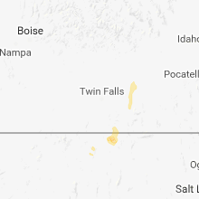
Idaho
| Local Time | Report Details |
|---|---|
| 3:25 PM MDT | Quarter sized hail reported near North Fork, ID, 15 miles NNW of Salmon, ID, covered the ground. time of report was derived from radar. |
| 3:26 PM MDT | Quarter sized hail reported near North Fork, ID, 15 miles NNW of Salmon, ID, damage to skylights and air conditioning units plus leaks on various rv’s. |
| 3:30 PM MDT | Quarter sized hail reported near North Fork, ID, 16.7 miles NNW of Salmon, ID, hail lasted 5 minutes. |
| 3:40 PM MDT | Quarter sized hail reported near Burley, ID, 34.7 miles E of Twin Falls, ID |
| 3:45 PM MDT | Quarter sized hail reported near Heyburn, ID, 36.2 miles E of Twin Falls, ID |
Texas
| Local Time | Report Details |
|---|---|
| 5:20 PM CDT | Golf Ball sized hail reported near Woodville, TX, 42.7 miles SSE of Lufkin, TX, public report estimated golf ball size hail near woodville. |
| 5:52 PM CDT | Ping Pong Ball sized hail reported near Vidor, TX, 21.4 miles NW of Beaumont, TX, social media photo shows ping pong ball sized hail along fm105 2 miles north of orange/jasper co line. |
| 6:00 PM CDT | Public photo shows large tree down across hwy 1131 north of vidor. time est from rada in orange county TX, 18.8 miles WNW of Beaumont, TX |
| 6:15 PM CDT | Trees and power lines down along mollywood roa in angelina county TX, 30.2 miles ESE of Lufkin, TX |
| 6:23 PM CDT | Quarter sized hail reported near Beaumont, TX, 27.2 miles W of Beaumont, TX, multiple reports of at least quarter size hail along major drive in nw beaumont. |
| 6:25 PM CDT | Golf Ball sized hail reported near Beaumont, TX, 26 miles W of Beaumont, TX, public reported golf ball sized hail near beaumont. |
| 6:58 PM CDT | Spotter reported several large trees down... limb and tree debris... and damage to a carport in the lakeview are in orange county TX, 19.3 miles WNW of Beaumont, TX |
| 6:58 PM CDT | Quarter sized hail reported near Alvin, TX, 19 miles S of Houston, TX |
| 7:20 PM CDT | Public reported wide swath of tree damage west of woodville near us 190 and county rd 217 in tyler county TX, 41.7 miles SSE of Lufkin, TX |
| 7:30 PM CDT | Damage to hangar at winnie-stowell airpor in chambers county TX, 45.6 miles WSW of Beaumont, TX |
| 8:48 PM CDT | Tree down in harris county TX, 10.4 miles ENE of Houston, TX |
| 8:50 PM CDT | Quarter sized hail reported near Humble, TX, 16.1 miles NNE of Houston, TX, reported from cwsu office at iah |
| 9:20 PM CDT | Power lines...road signs and trees down at sh-288 and broadwa in brazoria county TX, 13.8 miles S of Houston, TX |
| 9:41 PM CDT | Metal roof torn from two-story building at msr houston (near cr48s and sh 288 in brazoria county TX, 33.3 miles S of Houston, TX |
| 10:08 PM CDT | Storm damage reported in brazoria county TX, 40.9 miles S of Houston, TX |
New Jersey
| Local Time | Report Details |
|---|---|
| 7:13 PM EDT | 20-25 downed trees along armstrong blvd and apollo dr. (near rt 35) in twinbrook village. event time estimated from rada in monmouth county NJ, 29.3 miles S of Brooklyn, NY |
Montana
| Local Time | Report Details |
|---|---|
| 5:54 PM MDT | Quarter sized hail reported near Cardwell, MT, 44 miles WNW of Bozeman, MT, this is a follow up to the previous report of nickel size hail at this same location. spotter reports the hail has increased in size and is now up to the size of quarte |
| 6:32 PM MDT | Quarter sized hail reported near Cardwell, MT, 41.3 miles WNW of Bozeman, MT |
| 7:09 PM MDT | Hen Egg sized hail reported near Circle, MT, 46.5 miles SSE of Glasgow, MT, report... with photos... via social media. |
| 7:10 PM MDT | Golf Ball sized hail reported near Brockway, MT, 48 miles SSE of Glasgow, MT, report with photos via social media. |
| 8:05 PM MDT | Quarter sized hail reported near Livingston, MT, 30.7 miles E of Bozeman, MT |
| 8:36 PM MDT | Ping Pong Ball sized hail reported near Circle, MT, 65.7 miles N of Miles City, MT |
| 9:06 PM MDT | Quarter sized hail reported near Circle, MT, 70.4 miles N of Miles City, MT, hail the size of quarters and increasing in size; still hailing. |
| 9:08 PM MDT | Quarter sized hail reported near Reed Point, MT, 50 miles W of Billings, MT, measured and picture verification |
| 9:25 PM MDT | Ping Pong Ball sized hail reported near Circle, MT, 71 miles N of Miles City, MT |
| 9:30 PM MDT | Golf Ball sized hail reported near Richey, MT, 78.2 miles WSW of Williston, ND, reported via social media from a farm 5 miles south of richey. |
| 9:35 PM MDT | Ping Pong Ball sized hail reported near Circle, MT, 67.9 miles NNE of Miles City, MT, most of the hail was between quarters and golf balls. enough rain to have standing water on the road and lawn around the house |
| 9:40 PM MDT | Quarter sized hail reported near Richey, MT, 75 miles WSW of Williston, ND, more small hail... dimes... but quarters currently falling with heavy rain. |
| 10:05 PM MDT | Ping Pong Ball sized hail reported near Richey, MT, 78.5 miles WSW of Williston, ND, still hailing at time of report. |
| 10:30 PM MDT | Quarter sized hail reported near Lindsay, MT, 65.1 miles NNE of Miles City, MT, mostly pea size hail with a few quarters. heavy rain ongoing. |
| 10:48 PM MDT | Mesonet station mtsoo... sioux pas in richland county MT, 36.4 miles WSW of Williston, ND |
| 10:56 PM MDT | Ksdy asos station reported 43 mph sustained 66 mph gust at 1056 pm mdt in richland county MT, 38.7 miles SW of Williston, ND |
Wisconsin
| Local Time | Report Details |
|---|---|
| 7:36 PM CDT | Golf Ball sized hail reported near , , 52.1 miles NE of Green Bay, WI |
| 8:02 PM CDT | Quarter sized hail reported near Baileys Harbor, WI, 57.5 miles NE of Green Bay, WI |
Wyoming
| Local Time | Report Details |
|---|---|
| 9:30 PM MDT | Storm damage reported in campbell county WY, 48.6 miles SSW of Gillette, WY |
| 9:40 PM MDT | Storm damage reported in campbell county WY, 48.6 miles SSW of Gillette, WY |
North Dakota
| Local Time | Report Details |
|---|---|
| 12:46 AM CDT | Severe t-storm wind gust measure by davis weather instrumen in mckenzie county ND, 19.2 miles S of Williston, ND |
| 1:07 AM CDT | Corrects previous tstm wnd dmg report from 1 wnw arnegard. a barn (mobile home sized) was heavily damaged. estimated winds were 70 mp in mckenzie county ND, 24.3 miles SSE of Williston, ND |
| 1:08 AM CDT | A barn was reported damaged. report relayed by state radi in mckenzie county ND, 24.3 miles SSE of Williston, ND |
| 1:30 AM CDT | Possible microburst caused damage to a building in watford city. uncertain of wind speed or extent of the damage at this tim in mckenzie county ND, 28.7 miles SSE of Williston, ND |
| 1:55 AM CDT | Public report of a 60 mph wind gust and heavy rain. location was tobacco garden bay rec are in mckenzie county ND, 25.8 miles E of Williston, ND |
| 2:22 AM CDT | Thunderstorm wind gust estimated at 60 mph blew in a door and broke the loc in mckenzie county ND, 52.4 miles ESE of Williston, ND |
| 3:29 AM CDT | Observed wind gust of 60 miles per hou in mclean county ND, 40.4 miles S of Minot, ND |
Connect with Interactive Hail Maps