

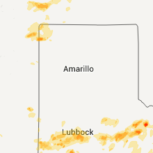
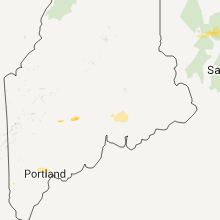
Hail Map for Thursday, May 28, 2015

Number of Impacted Households on 5/28/2015
0
Impacted by 1" or Larger Hail
0
Impacted by 1.75" or Larger Hail
0
Impacted by 2.5" or Larger Hail
Square Miles of Populated Area Impacted on 5/28/2015
0
Impacted by 1" or Larger Hail
0
Impacted by 1.75" or Larger Hail
0
Impacted by 2.5" or Larger Hail


Cities Most Affected by Hail Storms of 5/28/2015
| Hail Size | Demographics of Zip Codes Affected | ||||||
|---|---|---|---|---|---|---|---|
| City | Count | Average | Largest | Pop Density | House Value | Income | Age |
| Tribune, KS | 2 | 2.13 | 2.50 | 1 | $58k | $34.3k | 46.6 |
| Sedan, NM | 2 | 1.88 | 2.00 | 2 | $45k | $31.5k | 43.3 |
| Portales, NM | 2 | 1.75 | 1.75 | 28 | $55k | $26.6k | 29.0 |
| Norway, MI | 1 | 2.00 | 2.00 | 62 | $57k | $33.3k | 43.0 |
| Grafton, ND | 1 | 1.75 | 1.75 | 22 | $60k | $36.0k | 43.0 |
| Farmersville, TX | 1 | 1.75 | 1.75 | 86 | $76k | $44.3k | 38.6 |
| Rush Springs, OK | 1 | 1.75 | 1.75 | 10 | $43k | $25.3k | 40.9 |
Hail and Wind Damage Spotted on 5/28/2015
Filter by Report Type:Hail ReportsWind Reports
States Impacted
Oklahoma, Texas, Maine, New Hampshire, Vermont, Massachusetts, Arkansas, Connecticut, Kansas, Missouri, Colorado, Nebraska, Utah, Georgia, Wisconsin, New York, South Carolina, South Dakota, Louisiana, New Mexico, North Dakota, Minnesota, MichiganOklahoma
| Local Time | Report Details |
|---|---|
| 10:00 AM CDT | Considerable damage occurring to a home from line of thunderstorm in le flore county OK, 56.4 miles SW of Fort Smith, AR |
| 3:12 PM CDT | Golf Ball sized hail reported near Rush Springs, OK, 53.8 miles SSW of Oklahoma City, OK |
| 3:12 PM CDT | Quarter sized hail reported near Lawton, OK, 43.1 miles N of Wichita Falls, TX |
| 3:39 PM CDT | Ping Pong Ball sized hail reported near Lawton, OK, 49 miles N of Wichita Falls, TX |
| 6:30 PM CDT | Numerous trees down. shingle damag in tillman county OK, 24.7 miles NNW of Wichita Falls, TX |
| 6:35 PM CDT | Storm damage reported in tillman county OK, 26.1 miles NNW of Wichita Falls, TX |
| 6:36 PM CDT | Ping Pong Ball sized hail reported near Lawton, OK, 54.9 miles NNE of Wichita Falls, TX |
| 7:29 PM CDT | Damage to roof at truck stop at highways 70 and 81. winds estimated 60-70 mp in jefferson county OK, 33.9 miles ENE of Wichita Falls, TX |
| 7:31 PM CDT | Storm damage reported in stephens county OK, 37.4 miles NE of Wichita Falls, TX |
| 8:01 PM CDT | Substantial tree damag in stephens county OK, 51.2 miles NE of Wichita Falls, TX |
| 8:30 PM CDT | Trees snapped or uproote in carter county OK, 65.8 miles ENE of Wichita Falls, TX |
| 9:05 PM CDT | Storm damage reported in love county OK, 68 miles WSW of Atoka, OK |
Texas
| Local Time | Report Details |
|---|---|
| 11:30 AM CDT | Quarter sized hail reported near Whiteface, TX, 43.5 miles W of Lubbock, TX, up to quarter size covering ground. |
| 12:25 PM CDT | Quarter sized hail reported near Levelland, TX, 29.2 miles W of Lubbock, TX |
| 12:50 PM CDT | Likely microburst. power out for spec customer in lubbock county TX, 10.2 miles NW of Lubbock, TX |
| 12:54 PM CDT | Quarter sized hail reported near Shallowater, TX, 10.2 miles NW of Lubbock, TX, falling at the high school. streets flooded over curbs. |
| 1:01 PM CDT | Ping Pong Ball sized hail reported near Shallowater, TX, 10.2 miles NW of Lubbock, TX, falling now at middle school. |
| 1:25 PM CDT | Quarter sized hail reported near Lubbock, TX, 10 miles W of Lubbock, TX, nickel to quarter size. |
| 1:25 PM CDT | Several tree branches 2-3 inches in diameter broken off trees in lubbock county TX, 1.6 miles WSW of Lubbock, TX |
| 1:32 PM CDT | Ping Pong Ball sized hail reported near Lubbock, TX, 4.8 miles NNE of Lubbock, TX |
| 1:40 PM CDT | Power pole downed near 4th and quaker av in lubbock county TX, 3.1 miles W of Lubbock, TX |
| 1:45 PM CDT | Ping Pong Ball sized hail reported near Lubbock, TX, 3.3 miles NE of Lubbock, TX |
| 1:53 PM CDT | Ping Pong Ball sized hail reported near Lubbock, TX, 4.8 miles NNE of Lubbock, TX, metar observation. |
| 2:10 PM CDT | West texas mesonet in crosby county TX, 28.5 miles E of Lubbock, TX |
| 2:50 PM CDT | Quarter sized hail reported near Tahoka, TX, 30.5 miles SSW of Lubbock, TX |
| 3:10 PM CDT | Hen Egg sized hail reported near , , 52.7 miles S of Childress, TX |
| 3:13 PM CDT | Storm damage reported in foard county TX, 37.9 miles SE of Childress, TX |
| 3:45 PM CDT | Quarter sized hail reported near Odonnell, TX, 46.4 miles SSE of Lubbock, TX |
| 3:50 PM CDT | Quarter sized hail reported near , , 51.6 miles NNE of Alpine, TX |
| 3:55 PM CDT | Tree limbs dow in knox county TX, 51 miles SSE of Childress, TX |
| 3:56 PM CDT | Ping Pong Ball sized hail reported near Crowell, TX, 42.7 miles SE of Childress, TX |
| 4:12 PM CDT | Ping Pong Ball sized hail reported near Crowell, TX, 41.8 miles SE of Childress, TX, time estimated from radar. |
| 4:30 PM CDT | Quarter sized hail reported near Fluvanna, TX, 66.6 miles SE of Lubbock, TX, hail lasted for 15 minutes between 430 and 445 pm |
| 4:50 PM CDT | Storm damage reported in baylor county TX, 48.9 miles WSW of Wichita Falls, TX |
| 5:14 PM CDT | Storm damage reported in jones county TX, 34 miles N of Abilene, TX |
| 5:40 PM CDT | On county road 209 in throckmorton county TX, 55.8 miles NE of Abilene, TX |
| 5:45 PM CDT | Measured near county line road and hwy 287 in wichita county TX, 25.5 miles WNW of Wichita Falls, TX |
| 5:53 PM CDT | Storm damage reported in wichita county TX, 27.4 miles WNW of Wichita Falls, TX |
| 6:00 PM CDT | Power poles snapped in wichita county TX, 25.5 miles WNW of Wichita Falls, TX |
| 6:07 PM CDT | Ham radio spotter reports tree limbs snapped and one tree down on car in haynesville... estimated winds around 80 mph via anemomete in wichita county TX, 27.4 miles WNW of Wichita Falls, TX |
| 6:18 PM CDT | Storm damage reported in wichita county TX, 15 miles NNW of Wichita Falls, TX |
| 6:21 PM CDT | Public reports several tree limbs snapped and several trees uproote in archer county TX, 12.8 miles WSW of Wichita Falls, TX |
| 6:21 PM CDT | Quarter sized hail reported near Farmersville, TX, 36.6 miles NE of Dallas, TX, quarter size hail in farmersville |
| 6:26 PM CDT | Golf Ball sized hail reported near Farmersville, TX, 36.6 miles NE of Dallas, TX |
| 6:30 PM CDT | Quarter sized hail reported near Farmersville, TX, 36.6 miles NE of Dallas, TX |
| 6:30 PM CDT | Half Dollar sized hail reported near Farmersville, TX, 36.6 miles NE of Dallas, TX |
| 6:35 PM CDT | Power lines down at holiday and jacksbor in wichita county TX, 0.6 miles E of Wichita Falls, TX |
| 7:13 PM CDT | Trees down and roof blown off a large building near highway 380 and wesley chapel r in jack county TX, 52.3 miles SSE of Wichita Falls, TX |
| 7:35 PM CDT | Storm damage reported in tom green county TX, 82 miles SSW of Abilene, TX |
| 7:40 PM CDT | Storm damage reported in tom green county TX, 76.4 miles SW of Abilene, TX |
| 7:55 PM CDT | Storm damage reported in tom green county TX, 81 miles SSW of Abilene, TX |
| 7:56 PM CDT | Storm damage reported in tom green county TX, 79 miles SSW of Abilene, TX |
| 8:00 PM CDT | Tree down on power lines on avenue j in tom green county TX, 80.5 miles SSW of Abilene, TX |
| 8:01 PM CDT | Storm damage reported in tom green county TX, 77.8 miles SSW of Abilene, TX |
| 8:27 PM CDT | Storm damage reported in tom green county TX, 100.2 miles SSW of Abilene, TX |
| 9:25 PM CDT | Measured by the west texas mesonet in cochran county TX, 51.8 miles W of Lubbock, TX |
| 10:10 PM CDT | Estimated by experienced spotter in edwards county TX, 57.3 miles NE of Del Rio, TX |
| 11:07 PM CDT | Measured by kaq0 awos at llano muni airport in llano county TX, 60.1 miles WSW of Killeen, TX |
| 11:13 PM CDT | Downed trees on tivydale road and widespread power outages across town in gillespie county TX, 62.4 miles NNW of San Antonio, TX |
| 11:28 PM CDT | Trees down near pearl in coryell county TX, 28.3 miles NW of Killeen, TX |
| 12:00 AM CDT | Large tree limbs reported on hwy 281 near marble falls in burnet county TX, 49.1 miles SW of Killeen, TX |
| 12:12 AM CDT | Storm damage reported in burnet county TX, 53.1 miles SW of Killeen, TX |
| 12:40 AM CDT | Measured by hand held anemometer...5 inch thick tree limbs down on road in bexar county TX, 8.7 miles WSW of San Antonio, TX |
| 12:40 AM CDT | Storm damage reported in bexar county TX, 6 miles WSW of San Antonio, TX |
| 12:45 AM CDT | Large tree down in williamson county TX, 45.5 miles S of Killeen, TX |
| 12:49 AM CDT | Port san antonio asos kskf in bexar county TX, 6 miles WSW of San Antonio, TX |
| 4:25 AM CDT | Several tree branches down which have knocked some power lines down. some power outages in lared in webb county TX, 0.7 miles E of Laredo, TX |
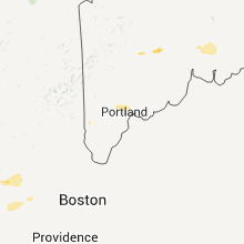
Maine
| Local Time | Report Details |
|---|---|
| 12:55 PM EDT | Roof ripped off a mobile in jay in franklin county ME, 58.1 miles N of Portland, ME |
| 12:59 PM EDT | Trees down on rt 17 in kennebec county ME, 55.7 miles N of Portland, ME |
| 1:27 PM EDT | Trees down in belgrade in kennebec county ME, 56.7 miles WSW of Bangor, ME |
| 1:30 PM EDT | Trees and wires down in somerset county ME, 53.4 miles WSW of Bangor, ME |
| 1:30 PM EDT | Trees down in kennebec county ME, 56.7 miles WSW of Bangor, ME |
| 1:40 PM EDT | Trees dow in kennebec county ME, 45.8 miles WSW of Bangor, ME |
| 1:50 PM EDT | Tree down rt 104. time estimated from radar in somerset county ME, 43.4 miles WSW of Bangor, ME |
| 1:55 PM EDT | Trees on car and camper... dock ripped out patties pond in kennebec county ME, 43.5 miles WSW of Bangor, ME |
| 2:04 PM EDT | Trees down in belgrade in kennebec county ME, 56.7 miles WSW of Bangor, ME |
| 2:32 PM EDT | Trees and wires down over mill street in raymond in cumberland county ME, 19.5 miles NNW of Portland, ME |
| 2:40 PM EDT | Multiple trees down on island in little sebago lake in cumberland county ME, 16 miles N of Portland, ME |
| 4:05 PM EDT | Tree and wires down on rt 104 in fairfield in somerset county ME, 45.5 miles WSW of Bangor, ME |
| 4:25 PM EDT | Power lines dow in york county ME, 26.8 miles W of Portland, ME |
| 4:30 PM EDT | Trees down on elm s in york county ME, 30.2 miles WSW of Portland, ME |
| 4:30 PM EDT | Trees and power lines down in york county ME, 24.7 miles WSW of Portland, ME |
| 4:35 PM EDT | Power lines down near tunnel road and harris roa in cumberland county ME, 9.7 miles N of Portland, ME |
| 4:37 PM EDT | Trees down at industry road and poor farm roa in somerset county ME, 55 miles W of Bangor, ME |
| 4:40 PM EDT | Trees down. delayed report. time estimated from rada in somerset county ME, 46.7 miles W of Bangor, ME |
| 4:55 PM EDT | Trees down. delayed report. time estimated from rada in somerset county ME, 38.9 miles W of Bangor, ME |
| 5:05 PM EDT | Trees down. delayed report. time estimated from rada in somerset county ME, 29.1 miles W of Bangor, ME |
| 5:05 PM EDT | Trees down. delayed report. time estimated from rada in somerset county ME, 30 miles W of Bangor, ME |
| 5:15 PM EDT | Trees down. delayed report. time estimated from rada in somerset county ME, 26 miles W of Bangor, ME |
New Hampshire
| Local Time | Report Details |
|---|---|
| 2:00 PM EDT | Storm damage reported in rockingham county NH, 48.5 miles SW of Portland, ME |
| 3:00 PM EDT | Trees down on headlands road on forest lake in cheshire county NH, 80.4 miles E of Schenectady, NY |
| 3:00 PM EDT | Tree and wires down on a car on rabbit hollow road in winchester in cheshire county NH, 81.4 miles E of Schenectady, NY |
| 3:23 PM EDT | Trees and wires down on martin cook road in cheshire county NH, 77.6 miles NW of Providence, RI |
| 3:32 PM EDT | Trees and wires down on fitzgerald drive in cheshire county NH, 74.6 miles NNW of Providence, RI |
| 4:00 PM EDT | Treess and power lines down in hillsborough county NH, 68.3 miles NNW of Providence, RI |
| 4:05 PM EDT | Large branches and power lines down in strafford county NH, 48.3 miles WSW of Portland, ME |
| 4:15 PM EDT | Large branches and power lines down in hillsborough county NH, 63.9 miles N of Providence, RI |
| 4:50 PM EDT | Multiple trees down in rockingham county NH, 67.6 miles N of Providence, RI |
Vermont
| Local Time | Report Details |
|---|---|
| 2:50 PM EDT | Quarter sized hail reported near Vernon, VT, 71.8 miles E of Schenectady, NY |
Massachusetts
| Local Time | Report Details |
|---|---|
| 3:00 PM EDT | Multiple trees and wires down on north poland rd in franklin county MA, 66.6 miles ESE of Schenectady, NY |
| 3:00 PM EDT | Trees and wires down on shelburne falls road in franklin county MA, 66.6 miles ESE of Schenectady, NY |
| 3:26 PM EDT | Trees and wires down in franklin county MA, 70.1 miles NW of Providence, RI |
| 4:05 PM EDT | Tree down on snell street blocking one lane in hampshire county MA, 68.7 miles NW of Providence, RI |
| 4:50 PM EDT | Large tree down on ware brook driv in hampshire county MA, 52.2 miles NW of Providence, RI |
| 5:10 PM EDT | Storm damage reported in essex county MA, 63.6 miles N of Providence, RI |
| 5:14 PM EDT | Limb and wires down on juniper lane in essex county MA, 66.2 miles NNE of Providence, RI |
| 5:15 PM EDT | Numerous trees and wires down across roads in essex county MA, 67.6 miles NNE of Providence, RI |
| 5:22 PM EDT | 4 telephone poles and trees and wires blown down on nabbys point road as confirmed by ema directo in essex county MA, 66 miles NNE of Providence, RI |
| 5:50 PM EDT | Tree down on wires on manhattan driv in middlesex county MA, 47.9 miles NNE of Providence, RI |
| 6:01 PM EDT | Large limb down on mbta tracks near greenwood statio in middlesex county MA, 50.5 miles NNE of Providence, RI |
| 6:10 PM EDT | Tree down on vincent rd. tree down on house on casco r in essex county MA, 50.5 miles NNE of Providence, RI |
| 6:10 PM EDT | 4 inch diameter tree limb down on salem street in essex county MA, 52.8 miles NNE of Providence, RI |
Arkansas
| Local Time | Report Details |
|---|---|
| 2:20 PM CDT | Large trees uprooted north of highfill. emergency manager also reports other damage in the count in benton county AR, 60.5 miles N of Fort Smith, AR |
Connecticut
| Local Time | Report Details |
|---|---|
| 3:30 PM EDT | Tree down on great plain roa in fairfield county CT, 58.5 miles NNE of Brooklyn, NY |
| 3:41 PM EDT | Quarter sized hail reported near Danbury, CT, 58.6 miles NNE of Brooklyn, NY, quarter size hail reported via ping project |
| 4:46 PM EDT | Numerous trees downed in fairfield county CT, 50.1 miles NNE of Brooklyn, NY |
Kansas
| Local Time | Report Details |
|---|---|
| 1:37 PM MDT | Quarter sized hail reported near Tribune, KS, 58.9 miles NW of Garden City, KS |
| 1:41 PM MDT | Half Dollar sized hail reported near Tribune, KS, 58.9 miles NW of Garden City, KS |
| 2:31 PM MDT | Quarter sized hail reported near Tribune, KS, 61.4 miles NW of Garden City, KS, relayed via spotter network. |
| 2:35 PM MDT | Golf Ball sized hail reported near Tribune, KS, 55 miles NW of Garden City, KS, relayed via spotter network. |
| 2:37 PM MDT | Tennis Ball sized hail reported near Tribune, KS, 54.6 miles NW of Garden City, KS, relayed via spotter network |
| 3:54 PM CDT | Quarter sized hail reported near Leoti, KS, 49.4 miles NW of Garden City, KS, relayed via spotter network |
| 3:55 PM CDT | Quarter sized hail reported near Leoti, KS, 36.2 miles NW of Garden City, KS, relayed via spotter network |
| 4:05 PM CDT | Quarter sized hail reported near Leoti, KS, 44.1 miles NW of Garden City, KS |
| 4:42 PM CDT | Half Dollar sized hail reported near Lakin, KS, 23.5 miles NW of Garden City, KS |
| 4:58 PM CDT | Quarter sized hail reported near Lakin, KS, 26.9 miles NW of Garden City, KS |
| 5:10 PM CDT | Quarter sized hail reported near Scott City, KS, 28.2 miles NNW of Garden City, KS |
| 5:20 PM CDT | Measured wind gust report relayed by the lane county dispatc in scott county KS, 30.2 miles N of Garden City, KS |
| 5:21 PM CDT | Storm damage reported in scott county KS, 30.5 miles NNE of Garden City, KS |
| 5:30 PM CDT | Transformer fire along highway 4 at the scott lane county line in scott county KS, 44.6 miles NNE of Garden City, KS |
| 5:48 PM CDT | Quarter sized hail reported near Lakin, KS, 21.8 miles NW of Garden City, KS |
| 5:52 PM CDT | Storm damage reported in lane county KS, 43.9 miles NNE of Garden City, KS |
| 6:11 PM CDT | Storm damage reported in ness county KS, 50.6 miles WSW of Hays, KS |
| 6:15 PM CDT | Storm damage reported in ness county KS, 51.9 miles ENE of Garden City, KS |
| 6:35 PM CDT | Storm damage reported in ness county KS, 28.3 miles WSW of Hays, KS |
| 6:35 PM CDT | Storm damage reported in ness county KS, 42.7 miles SW of Hays, KS |
Missouri
| Local Time | Report Details |
|---|---|
| 2:46 PM CDT | Several reports of small limbs down around the st. peters area between 246 pm and 300 p in st. charles county MO, 24.5 miles WNW of Saint Louis, MO |
| 3:46 PM CDT | Fire chief reported tree branches down 10-15 inches in diameter. power lines down... power pole snapped. hail pea to nickel siz in lafayette county MO, 55.5 miles E of Kansas City, MO |
Colorado
| Local Time | Report Details |
|---|---|
| 2:05 PM MDT | Ping Pong Ball sized hail reported near Iliff, CO, 47.9 miles NNW of Yuma, CO |
| 2:18 PM MDT | Quarter sized hail reported near Elizabeth, CO, 33 miles SE of Denver, CO |
| 2:24 PM MDT | Quarter sized hail reported near Flagler, CO, 60.1 miles SSW of Yuma, CO, quarter size hail mixing with penny. |
| 3:17 PM MDT | Quarter sized hail reported near Arapahoe, CO, 67.1 miles SW of Colby, KS, quarter and dime size hail... on hwy 40... mile marker 486 |
| 3:21 PM MDT | Quarter sized hail reported near Arapahoe, CO, 73.5 miles SW of Colby, KS |
| 3:34 PM MDT | Quarter sized hail reported near Stratton, CO, 61.6 miles S of Yuma, CO |
| 4:00 PM MDT | Quarter sized hail reported near Bethune, CO, 64.8 miles SSE of Yuma, CO, mostly marble size hail... some quarter mixed in. |
| 7:53 PM MDT | Quarter sized hail reported near Aurora, CO, 7.2 miles E of Denver, CO |
Nebraska
| Local Time | Report Details |
|---|---|
| 2:10 PM MDT | Quarter sized hail reported near Bridgeport, NE, 34.5 miles SE of Scottsbluff, NE |
| 6:52 PM CDT | Quarter sized hail reported near Hershey, NE, 12.5 miles W of North Platte, NE, in addition to the hail... very heavy rain was falling... which was reducing visibilities to a quarter of a mile. |
| 7:10 PM CDT | Quarter sized hail reported near Hershey, NE, 12.5 miles W of North Platte, NE |
Utah
| Local Time | Report Details |
|---|---|
| 2:40 PM MDT | Ping Pong Ball sized hail reported near Honeyville, UT, 60.9 miles N of Salt Lake City, UT, ping pong size hail observed and photographed in honeyville. time estimated. |
| 3:30 PM MDT | Storm damage reported in grand county UT, 67.1 miles W of Grand Junction, CO |
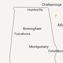
Georgia
| Local Time | Report Details |
|---|---|
| 5:05 PM EDT | Quarter sized hail reported near Sugar Valley, GA, 37.6 miles SSE of Chattanooga, TN, mostly dime to nickle size hail but few up to quarter size. |
| 5:32 PM EDT | Tree down along south dixie highway and rabbit way in whitfield county GA, 33.4 miles SE of Chattanooga, TN |
| 5:36 PM EDT | A tree down across mary elizabeth drive in whitfield county GA, 32.6 miles SE of Chattanooga, TN |
Wisconsin
| Local Time | Report Details |
|---|---|
| 4:11 PM CDT | Quarter sized hail reported near Niagara, WI, 61.1 miles SSW of Marquette, MI, on hwy 141 |
New York
| Local Time | Report Details |
|---|---|
| 5:26 PM EDT | Downed tree on smith ridge roa in westchester county NY, 49.2 miles NNE of Brooklyn, NY |
| 5:26 PM EDT | Downed tree on spring stree in westchester county NY, 46 miles NNE of Brooklyn, NY |
| 5:31 PM EDT | Downed tree on smith ridge roa in westchester county NY, 44.5 miles NNE of Brooklyn, NY |
| 5:31 PM EDT | Downed tree on smith ridge roa in westchester county NY, 49.2 miles NNE of Brooklyn, NY |
South Carolina
| Local Time | Report Details |
|---|---|
| 5:37 PM EDT | Tree down near intersection of cannon campground rd and west church s in spartanburg county SC, 45.6 miles ENE of Greenville, SC |
| 5:37 PM EDT | Tree down at intersection of cannon campground rd and old converse r in spartanburg county SC, 44.4 miles ENE of Greenville, SC |
| 5:46 PM EDT | Tree blown down near sc state road 150 and jerusalem r in spartanburg county SC, 47.4 miles E of Greenville, SC |
South Dakota
| Local Time | Report Details |
|---|---|
| 5:10 PM CDT | Quarter sized hail reported near Reliance, SD, 56.1 miles SE of Pierre, SD, many quarter sized hail stones |
| 6:25 PM MDT | Brief burst of wind along with pea size hail for about 2 minutes in shannon county SD, 71.4 miles SE of Rapid City, SD |
Louisiana
| Local Time | Report Details |
|---|---|
| 5:30 PM CDT | Highway 501 weset of winnfield numerous trees down in winn county LA, 72.3 miles SE of Shreveport, LA |
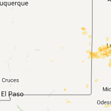
New Mexico
| Local Time | Report Details |
|---|---|
| 4:32 PM MDT | Quarter sized hail reported near Cannon AFB, NM, 59.3 miles SSE of Tucumcari, NM, kcvs asos. mostly 0.50 inch...but a number of 1.00 inch stones measured by cannon afb weather |
| 4:42 PM MDT | Quarter sized hail reported near Clovis, NM, 63.7 miles SSE of Tucumcari, NM |
| 4:55 PM MDT | Hen Egg sized hail reported near Sedan, NM, 74.8 miles NNE of Tucumcari, NM, hen egg size hail from 455 to 505pm. |
| 5:05 PM MDT | Golf Ball sized hail reported near Sedan, NM, 75.5 miles NNE of Tucumcari, NM |
| 5:28 PM MDT | Quarter sized hail reported near Sedan, NM, 74.9 miles NNE of Tucumcari, NM |
| 6:05 PM MDT | Quarter sized hail reported near Portales, NM, 70.8 miles SSE of Tucumcari, NM |
| 6:22 PM MDT | Ping Pong Ball sized hail reported near Portales, NM, 73.1 miles SSE of Tucumcari, NM |
| 6:32 PM MDT | Ping Pong Ball sized hail reported near Portales, NM, 72.2 miles SSE of Tucumcari, NM |
| 6:33 PM MDT | Golf Ball sized hail reported near Portales, NM, 73.1 miles SSE of Tucumcari, NM |
| 6:34 PM MDT | Golf Ball sized hail reported near Portales, NM, 72.2 miles SSE of Tucumcari, NM |
North Dakota
| Local Time | Report Details |
|---|---|
| 5:33 PM CDT | Golf Ball sized hail reported near Grafton, ND, 72.5 miles WSW of Roseau, MN, via facebook. |
| 7:45 PM CDT | Quarter sized hail reported near Fullerton, ND, 49.2 miles N of Aberdeen, SD, relayed via social media with picture... mostly pea size with quarters mixed in. also received 2 inches of rain in 30 minutes. |
Minnesota
| Local Time | Report Details |
|---|---|
| 6:09 PM CDT | Estimated winds along with drifts of pea sized hai in kittson county MN, 47.5 miles WSW of Roseau, MN |
| 6:30 PM CDT | Hen Egg sized hail reported near , , 30.9 miles E of Roseau, MN, facebook photo of 2 inch spiked hail |
Michigan
| Local Time | Report Details |
|---|---|
| 6:15 PM CDT | Quarter sized hail reported near Vulcan, MI, 56.8 miles SSW of Marquette, MI, report via social media. quarter sized hail reported between norway and vulcan. delayed report. |
| 7:25 PM CDT | Quarter sized hail reported near Norway, MI, 57.8 miles SSW of Marquette, MI, co-op observer reports quarter sized hail in norway. |
| 7:34 PM CDT | Hen Egg sized hail reported near Norway, MI, 57.2 miles SSW of Marquette, MI, estimated 2.0 inch hail reported in norway. report via social media. |
Connect with Interactive Hail Maps