

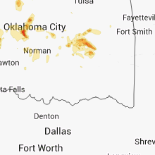
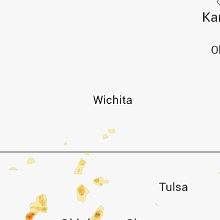
Hail Map for Wednesday, September 26, 2012

Number of Impacted Households on 9/26/2012
0
Impacted by 1" or Larger Hail
0
Impacted by 1.75" or Larger Hail
0
Impacted by 2.5" or Larger Hail
Square Miles of Populated Area Impacted on 9/26/2012
0
Impacted by 1" or Larger Hail
0
Impacted by 1.75" or Larger Hail
0
Impacted by 2.5" or Larger Hail

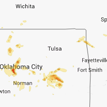


Cities Most Affected by Hail Storms of 9/26/2012
| Hail Size | Demographics of Zip Codes Affected | ||||||
|---|---|---|---|---|---|---|---|
| City | Count | Average | Largest | Pop Density | House Value | Income | Age |
| Yukon, OK | 2 | 2.38 | 3.00 | 529 | $87k | $49.1k | 35.3 |
| Grove, OK | 1 | 2.00 | 2.00 | 161 | $104k | $27.4k | 50.1 |
| Hanna, OK | 1 | 2.00 | 2.00 | 3 | $20k | $22.3k | 37.2 |
| Galena, MO | 1 | 1.75 | 1.75 | 41 | $84k | $31.3k | 46.7 |
| Canadian, OK | 1 | 1.75 | 1.75 | 43 | $57k | $28.2k | 49.4 |
| Enid, OK | 1 | 1.75 | 1.75 | 170 | $39k | $26.6k | 33.1 |
| Stratton, CO | 1 | 1.75 | 1.75 | 2 | $77k | $35.0k | 37.2 |
| Mustang, OK | 1 | 1.75 | 1.75 | 424 | $87k | $50.7k | 36.8 |
| Dawson Springs, KY | 1 | 1.75 | 1.75 | 52 | $47k | $24.9k | 42.2 |
| Bella Vista, AR | 1 | 1.75 | 1.75 | 649 | $104k | $44.0k | 41.9 |
Hail and Wind Damage Spotted on 9/26/2012
Filter by Report Type:Hail ReportsWind Reports
States Impacted
Oklahoma, Colorado, Missouri, Texas, West Virginia, Kentucky, Kansas, Ohio, ArkansasOklahoma
| Local Time | Report Details |
|---|---|
| 1:54 PM CDT | Ping Pong Ball sized hail reported near Weleetka, OK, 56 miles S of Tulsa, OK |
| 2:50 PM CDT | Quarter sized hail reported near Dustin, OK, 60.7 miles S of Tulsa, OK |
| 3:14 PM CDT | Quarter sized hail reported near Hanna, OK, 60.5 miles N of Atoka, OK, quarter size hail observed at hwy 9 and the indian nation turnpike. |
| 3:27 PM CDT | Hen Egg sized hail reported near Hanna, OK, 59 miles NNE of Atoka, OK |
| 3:29 PM CDT | Half Dollar sized hail reported near Hanna, OK, 62 miles S of Tulsa, OK, law enforcement reporting half dollar hail on hwy 9 2 east of sh 52. relayed through em. |
| 4:05 PM CDT | Quarter sized hail reported near Canadian, OK, 56.9 miles NNE of Atoka, OK |
| 4:06 PM CDT | Golf Ball sized hail reported near Canadian, OK, 56.9 miles NNE of Atoka, OK, storm chaser reported quarter size hail with occasional golf ball hail. relayed by media. |
| 4:06 PM CDT | Storm chaser estimated 80 mph winds. relyaed by medi in pittsburg county OK, 56.9 miles NNE of Atoka, OK |
| 5:12 PM CDT | Quarter sized hail reported near McAlester, OK, 42.7 miles NNE of Atoka, OK |
| 5:18 PM CDT | Scattered limbs down around tow in pittsburg county OK, 42.7 miles NNE of Atoka, OK |
| 5:33 PM CDT | Quarter sized hail reported near McAlester, OK, 43.9 miles NNE of Atoka, OK, dime to quarter hail reported. |
| 6:07 PM CDT | Hen Egg sized hail reported near Grove, OK, 76.1 miles ENE of Tulsa, OK, pictures received of golfball and hen egg hail. |
| 6:17 PM CDT | Half Dollar sized hail reported near Grove, OK, 80 miles ENE of Tulsa, OK, half dollar size hail lasted about 3 min and the seneca-cayuga dept of public safety. |
| 7:45 PM CDT | Quarter sized hail reported near Goodwell, OK, 88 miles SW of Garden City, KS |
| 8:08 PM CDT | Quarter sized hail reported near El Reno, OK, 24.5 miles W of Oklahoma City, OK, reported on the west side of town |
| 8:25 PM CDT | Quarter sized hail reported near Guymon, OK, 84.9 miles SSW of Garden City, KS, also estimated wind gusts to 50 mph. |
| 8:39 PM CDT | Half Dollar sized hail reported near Guymon, OK, 82.4 miles SSW of Garden City, KS, hail covering the ground. also estimated wind gusts between 50 and 60 mph. |
| 8:55 PM CDT | Half Dollar sized hail reported near Hooker, OK, 79.7 miles SSW of Garden City, KS |
| 9:05 PM CDT | Half Dollar sized hail reported near Hooker, OK, 78.7 miles SSW of Garden City, KS |
| 9:12 PM CDT | Quarter sized hail reported near Guymon, OK, 94.3 miles SSW of Garden City, KS |
| 9:13 PM CDT | Half Dollar sized hail reported near Seiling, OK, 34.8 miles SE of Woodward, OK |
| 9:14 PM CDT | Half Dollar sized hail reported near Hooker, OK, 78.7 miles SSW of Garden City, KS |
| 9:14 PM CDT | Quarter sized hail reported near Guymon, OK, 93.7 miles SSW of Garden City, KS |
| 9:18 PM CDT | Golf Ball sized hail reported near Hooker, OK, 78.7 miles SSW of Garden City, KS |
| 9:23 PM CDT | Golf Ball sized hail reported near Mustang, OK, 14.7 miles WSW of Oklahoma City, OK |
| 9:25 PM CDT | Tea Cup sized hail reported near Yukon, OK, 16.2 miles WSW of Oklahoma City, OK |
| 9:25 PM CDT | Storm damage reported in jackson county OK, 51.5 miles ENE of Childress, TX |
| 9:31 PM CDT | Storm damage reported in tillman county OK, 43.3 miles NW of Wichita Falls, TX |
| 9:32 PM CDT | Quarter sized hail reported near Cordell, OK, 69.5 miles WSW of Oklahoma City, OK |
| 9:45 PM CDT | Golf Ball sized hail reported near Yukon, OK, 15.8 miles W of Oklahoma City, OK |
| 10:30 PM CDT | Storm damage reported in comanche county OK, 56.7 miles N of Wichita Falls, TX |
| 10:45 PM CDT | Storm damage reported in comanche county OK, 56.7 miles N of Wichita Falls, TX |
| 10:55 PM CDT | Storm damage reported in grady county OK, 27.8 miles WSW of Oklahoma City, OK |
| 11:00 PM CDT | Storm damage reported in grady county OK, 27.8 miles WSW of Oklahoma City, OK |
| 11:10 PM CDT | Storm damage reported in grady county OK, 27.8 miles WSW of Oklahoma City, OK |
| 11:15 PM CDT | Storm damage reported in grady county OK, 27.8 miles WSW of Oklahoma City, OK |
| 11:49 PM CDT | Golf Ball sized hail reported near Enid, OK, 67.8 miles N of Oklahoma City, OK |
Colorado
| Local Time | Report Details |
|---|---|
| 3:05 PM MDT | Quarter sized hail reported near Kim, CO, 88.4 miles SE of Pueblo, CO, 3/4 to 1 inch hail covering the ground to a depth of 3 inches. |
| 3:43 PM MDT | Quarter sized hail reported near Trinidad, CO, 67.7 miles NE of Taos, NM, hail was fairly soft. |
| 6:10 PM MDT | Quarter sized hail reported near Walsh, CO, 94.4 miles SW of Garden City, KS, ended 620 pm. mostly nickle size hail. hail fall 2 inches deep on the ground. |
| 6:20 PM MDT | Quarter sized hail reported near Seibert, CO, 56.8 miles S of Yuma, CO, hail up to 2 inches deep on highway 24 |
| 7:19 PM MDT | Golf Ball sized hail reported near Stratton, CO, 64.4 miles S of Yuma, CO, hail covering the ground to several inches |
Missouri
| Local Time | Report Details |
|---|---|
| 4:27 PM CDT | Half Dollar sized hail reported near Broseley, MO, 57.6 miles SW of Cape Girardeau, MO, reported at intersection of highway aa and county road 629 in broseley. |
| 8:25 PM CDT | Quarter sized hail reported near Noel, MO, 80 miles SW of Springfield, MO, nickel to quarter hail in noel |
| 9:10 PM CDT | Golf Ball sized hail reported near Galena, MO, 23.7 miles S of Springfield, MO, communications received report of near golf ball hail just southwest of town. |
| 9:10 PM CDT | Quarter sized hail reported near Galena, MO, 24.8 miles SSW of Springfield, MO, 1 inch hail reported at abesville. |
| 9:15 PM CDT | Quarter sized hail reported near Reeds Spring, MO, 25.4 miles S of Springfield, MO |
| 11:16 PM CDT | Quarter sized hail reported near Ozark, MO, 16.1 miles SSE of Springfield, MO |
Texas
| Local Time | Report Details |
|---|---|
| 4:43 PM CDT | West texas mesonet report in hockley county TX, 22 miles WNW of Lubbock, TX |
| 5:10 PM CDT | West texas mesonet report in lubbock county TX, 10 miles W of Lubbock, TX |
| 5:32 PM CDT | West texas mesonet report in briscoe county TX, 55.9 miles W of Childress, TX |
| 5:38 PM CDT | West texas mesonet report in hale county TX, 19.3 miles NNE of Lubbock, TX |
| 5:50 PM CDT | Quarter sized hail reported near Tarzan, TX, 43 miles NNE of Odessa, TX |
| 5:50 PM CDT | Storm damage reported in martin county TX, 43 miles NNE of Odessa, TX |
| 5:50 PM CDT | Lcu baseball centerfield wall blown down in lubbock county TX, 1.6 miles WSW of Lubbock, TX |
| 6:02 PM CDT | Trained spotter coop report in garza county TX, 23.8 miles SE of Lubbock, TX |
| 6:12 PM CDT | Tv weather station report in lubbock county TX, 13.4 miles NE of Lubbock, TX |
| 6:32 PM CDT | Windows blown out of vechicles and light pole blown over on texas tech campus in lubbock county TX, 1.6 miles WSW of Lubbock, TX |
| 6:32 PM CDT | Windows blown out of vehicles and light pole blown over on texas tech campus in lubbock county TX, 1.6 miles WSW of Lubbock, TX |
| 6:35 PM CDT | *** 1 inj *** us highway 84 southbound closed due to tractor trailer truck blown over. driver injure in lubbock county TX, 16.3 miles SE of Lubbock, TX |
| 7:30 PM CDT | 59 mph gust at 725 and 60 mph at 73 in cottle county TX, 37.9 miles SSW of Childress, TX |
| 7:30 PM CDT | 59 mph gust at 725 and 60 mph at 735. measured by west tx mesone in cottle county TX, 37.9 miles SSW of Childress, TX |
| 7:35 PM CDT | Downed tree damaged a fenc in cottle county TX, 38.9 miles SSW of Childress, TX |
| 7:45 PM CDT | West texas mesonet report in king county TX, 61.2 miles SSW of Childress, TX |
| 10:00 PM CDT | Power lines blown down and irrigation sprinkler system knocked over. time is estimated based on rada in ochiltree county TX, 89 miles W of Woodward, OK |
| 10:08 PM CDT | Half Dollar sized hail reported near Waka, TX, 88.9 miles W of Woodward, OK, reported quarter size to half dollar size hail |
| 10:30 PM CDT | Storm damage reported in ochiltree county TX, 87.9 miles W of Woodward, OK |
West Virginia
| Local Time | Report Details |
|---|---|
| 6:20 PM EDT | Quarter sized hail reported near Leon, WV, 30.1 miles NNW of Charleston, WV |
| 6:20 PM EDT | Quarter sized hail reported near Leon, WV, 27.7 miles NNW of Charleston, WV |
| 6:42 PM EDT | Quarter sized hail reported near Horner, WV, 34.2 miles W of Elkins, WV |
| 7:00 PM EDT | Trees down along sycamore run rd north of glenvill in gilmer county WV, 52.6 miles W of Elkins, WV |
| 8:35 PM EDT | Quarter sized hail reported near Ripley, WV, 31.8 miles N of Charleston, WV |
Kentucky
| Local Time | Report Details |
|---|---|
| 7:15 PM EDT | Quarter sized hail reported near Grayson, KY, 72.3 miles W of Charleston, WV |
| 6:23 PM CDT | Golf Ball sized hail reported near Dawson Springs, KY, 48.5 miles SSW of Evansville, IN, also winds gusting up to 40 mph |
| 7:32 PM EDT | Quarter sized hail reported near Ashland, KY, 62 miles W of Charleston, WV |
| 7:41 PM EDT | Quarter sized hail reported near Catlettsburg, KY, 57.7 miles W of Charleston, WV |
Kansas
| Local Time | Report Details |
|---|---|
| 7:49 PM CDT | Storm damage reported in morton county KS, 82.4 miles SW of Garden City, KS |
| 7:51 PM CDT | Quarter sized hail reported near Elkhart, KS, 86.3 miles SW of Garden City, KS |
| 8:30 PM CDT | Storm damage reported in morton county KS, 74.9 miles SSW of Garden City, KS |
Ohio
| Local Time | Report Details |
|---|---|
| 9:28 PM EDT | Quarter sized hail reported near Lucasville, OH, 70.7 miles S of Columbus, OH |
| 9:50 PM EDT | Quarter sized hail reported near Oak Hill, OH, 69.9 miles NW of Charleston, WV, along riegel ridge rd |
Arkansas
| Local Time | Report Details |
|---|---|
| 8:58 PM CDT | Half Dollar sized hail reported near Hiwasse, AR, 72.3 miles N of Fort Smith, AR, duration of hail was approximately 5 minutes. |
| 8:59 PM CDT | Golf Ball sized hail reported near Bella Vista, AR, 72.8 miles N of Fort Smith, AR, spotter 4 to 5 east of hiwasse on h |
| 8:59 PM CDT | Spotter 4 to 5 e of hiwasse on hwy 72 estimated wind gust to 65 mp in benton county AR, 72.8 miles N of Fort Smith, AR |
| 9:15 PM CDT | Quarter sized hail reported near Bentonville, AR, 69 miles N of Fort Smith, AR |
Connect with Interactive Hail Maps