

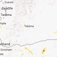
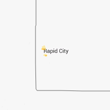
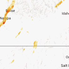
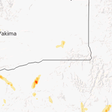
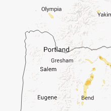
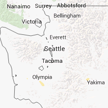
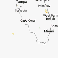
Hail Map for Thursday, September 5, 2013

Number of Impacted Households on 9/5/2013
0
Impacted by 1" or Larger Hail
0
Impacted by 1.75" or Larger Hail
0
Impacted by 2.5" or Larger Hail
Square Miles of Populated Area Impacted on 9/5/2013
0
Impacted by 1" or Larger Hail
0
Impacted by 1.75" or Larger Hail
0
Impacted by 2.5" or Larger Hail


Cities Most Affected by Hail Storms of 9/5/2013
| Hail Size | Demographics of Zip Codes Affected | ||||||
|---|---|---|---|---|---|---|---|
| City | Count | Average | Largest | Pop Density | House Value | Income | Age |
| Hill City, SD | 1 | 2.75 | 2.75 | 3 | $97k | $36.2k | 47.3 |
| Bend, OR | 1 | 1.75 | 1.75 | 92 | $155k | $43.3k | 38.5 |
| Jordan Valley, OR | 1 | 1.75 | 1.75 | 0 | $55k | $27.5k | 48.6 |
| Heppner, OR | 1 | 1.75 | 1.75 | 1 | $81k | $36.1k | 48.5 |
Hail and Wind Damage Spotted on 9/5/2013
Filter by Report Type:Hail ReportsWind Reports
South Dakota
| Local Time | Report Details |
|---|---|
| 2:19 PM MDT | Baseball sized hail reported near Hill City, SD, 20.9 miles W of Rapid City, SD |
| 3:53 PM MDT | Quarter sized hail reported near Lead, SD, 32.6 miles NW of Rapid City, SD |
| 4:02 PM MDT | Ping Pong Ball sized hail reported near Deadwood, SD, 27.7 miles WNW of Rapid City, SD |
Oregon
| Local Time | Report Details |
|---|---|
| 2:26 PM MDT | Golf Ball sized hail reported near Jordan Valley, OR, 61.2 miles SW of Boise, ID, estimated golf ball size hail from photo. |
| 2:06 PM PDT | Quarter sized hail reported near Bend, OR, 53.5 miles WSW of Bend, OR |
| 2:20 PM PDT | Quarter sized hail reported near , , 38.4 miles WSW of Bend, OR |
| 2:40 PM PDT | Golf Ball sized hail reported near Bend, OR, 28.2 miles SW of Bend, OR, near intersection of highway 97 and empire avenue. |
| 2:58 PM PDT | Six miles se of the town of sisters. quarter size hail also. wind gusts between 60 to 70 mp in deschutes county OR, 31 miles W of Bend, OR |
| 3:09 PM PDT | Quarter sized hail reported near Heppner, OR, 74.3 miles SW of Walla Walla, WA |
| 3:10 PM PDT | Golf Ball sized hail reported near Heppner, OR, 74.1 miles SW of Walla Walla, WA |
| 3:11 PM PDT | Quarter sized hail reported near Sisters, OR, 35 miles W of Bend, OR, quarter size hail persisted for five minutes. |
| 3:30 PM PDT | 1/2 inch hail in grant county OR, 62.7 miles NNE of Burns, OR |
| 3:30 PM PDT | Storm damage reported in grant county OR, 62.7 miles NNE of Burns, OR |
| 3:45 PM PDT | Chimney blown off hous in jefferson county OR, 32.7 miles NW of Bend, OR |
| 4:00 PM PDT | 4 two foot diameter trees uprooted. irrigation pivots overturne in jefferson county OR, 39.1 miles NW of Bend, OR |
| 4:30 PM PDT | Quarter sized hail reported near Moro, OR, 76.6 miles N of Bend, OR |
| 4:45 PM PDT | Large tree down in umatilla county OR, 38.7 miles SW of Walla Walla, WA |
| 5:00 PM PDT | 1/2 inch hail in grant county OR, 62.7 miles NNE of Burns, OR |
| 5:00 PM PDT | 0.70 inch rain in umatilla county OR, 5.9 miles SW of Walla Walla, WA |
| 5:00 PM PDT | Quarter sized hail reported near Moro, OR, 76.6 miles N of Bend, OR |
| 5:20 PM PDT | 10 inch trees down in umatilla county OR, 10 miles SSW of Walla Walla, WA |
| 5:20 PM PDT | Many cottonwood trees on neighbors property damaged with tops broken off in high wind in umatilla county OR, 10.5 miles S of Walla Walla, WA |
| 5:25 PM PDT | 0.70 inch rain in umatilla county OR, 5.9 miles SW of Walla Walla, WA |
| 5:30 PM PDT | 50 foot spruce tree down. large maple tree broke in half. flooding in driveway from heavy rai in umatilla county OR, 10.8 miles SW of Walla Walla, WA |
California
| Local Time | Report Details |
|---|---|
| 2:00 PM PDT | Mesonet station mataguay /mgysd/ in san diego county CA, 43.9 miles NE of San Diego, CA |
| 2:00 PM PDT | County reported tree down blocking deer creek trail in san diego county CA, 37.6 miles ENE of San Diego, CA |
| 2:00 PM PDT | County reported tree down blocking roadway in san diego county CA, 37.6 miles ENE of San Diego, CA |
| 2:10 PM PDT | Mesonet station warners /warsd/ in san diego county CA, 45.6 miles NE of San Diego, CA |
| 2:20 PM PDT | San diego county reports trees down on valley view and deer creek trail roads in san diego county CA, 41.3 miles NE of San Diego, CA |
Georgia
| Local Time | Report Details |
|---|---|
| 5:10 PM EDT | Tree down blocking the road across highway 301. time of event based on rada in brantley county GA, 55.3 miles ESE of Douglas, GA |
Idaho
| Local Time | Report Details |
|---|---|
| 3:41 PM MDT | Half Dollar sized hail reported near Meridian, ID, 13.4 miles W of Boise, ID, spotter reports thunderstorm with 1/2 inch to golfball size hail almost covering the surface of the ground. |
| 3:41 PM MDT | Quarter sized hail reported near Horseshoe Bend, ID, 20.2 miles N of Boise, ID, spotter reports thunderstorm with 1 inch hail and wind gusts to 60 mph. |
| 3:45 PM MDT | Ping Pong Ball sized hail reported near Meridian, ID, 10.4 miles W of Boise, ID, hail greater than 1 inch. half size of small yoyo. |
| 4:00 PM MDT | Quarter sized hail reported near Meridian, ID, 10.4 miles W of Boise, ID, photo of hail slightly larger than a quarter. |
| 4:15 PM MDT | Half Dollar sized hail reported near Eagle, ID, 10.1 miles NW of Boise, ID, estimated 1.25 inch hail from photos. |
| 4:22 PM MDT | Half Dollar sized hail reported near Eagle, ID, 11 miles NW of Boise, ID, half dollar hail and 45 mph winds. |
| 4:26 PM MDT | Ping Pong Ball sized hail reported near Eagle, ID, 14 miles NW of Boise, ID, ping pong ball size hail on highway 55 north of eagle. |
| 4:30 PM MDT | Cwop e2058 station in boise county ID, 17.6 miles N of Boise, ID |
| 5:00 PM MDT | Half Dollar sized hail reported near Cascade, ID, 62.8 miles N of Boise, ID |
| 5:50 PM MDT | Blue dome in clark county ID, 53.5 miles NW of Idaho Falls, ID |
| 5:51 PM MDT | Kriley creek raws at 5200ft in lemhi county ID, 12.7 miles N of Salmon, ID |
| 6:17 PM MDT | Storm damage reported in clark county ID, 54.7 miles NNW of Idaho Falls, ID |
| 6:36 PM MDT | Storm damage reported in lemhi county ID, 3.2 miles SW of Salmon, ID |
| 6:51 PM MDT | Trees down and power outage in s in lemhi county ID, 12.7 miles N of Salmon, ID |
Montana
| Local Time | Report Details |
|---|---|
| 4:13 PM MDT | 62 mph convective wind gust at the great falls airpor in cascade county MT, 4.3 miles SW of Great Falls, MT |
| 4:13 PM MDT | Tree damage from thunderstorm outflow boundary winds....tree was snapped in half and was estimated to be 8 to 10 inches in diameter in cascade county MT, 5.8 miles SW of Great Falls, MT |
| 4:55 PM MDT | Estimated 60 mph wind gus in chouteau county MT, 21.6 miles NNE of Great Falls, MT |
| 6:50 PM MDT | 66 mph wind gust in jefferson county MT, 55.7 miles WNW of Bozeman, MT |
| 6:53 PM MDT | Ingomar dot in rosebud county MT, 74.9 miles W of Miles City, MT |
| 6:57 PM MDT | 60 mph wind gus in hill county MT, 47.2 miles WNW of Havre, MT |
| 6:57 PM MDT | 60 mph wind gus in hill county MT, 42.6 miles W of Havre, MT |
| 7:00 PM MDT | Vehicle rollover on i-90....mobile home damage...numerous reports of roof damage and powerlines down in the whitehall area in jefferson county MT, 53.2 miles WNW of Bozeman, MT |
| 7:15 PM MDT | Estimated wind gusts of 60 mp in hill county MT, 25.6 miles WNW of Havre, MT |
| 7:17 PM MDT | Portion of barn roof blown off. cattle trailer tipped ove in rosebud county MT, 32.1 miles W of Miles City, MT |
| 7:30 PM MDT | 79 mph wind gust...with a pivot tipped ove in jefferson county MT, 49.8 miles WNW of Bozeman, MT |
| 7:32 PM MDT | Spotter also reported very heavy rainfall in jefferson county MT, 49.8 miles WNW of Bozeman, MT |
Florida
| Local Time | Report Details |
|---|---|
| 8:12 PM EDT | A couple of homes received minor damage to a roof...porch...lanai and a fence. winds estimated at 40 to 50 mph. timing estimated off of rada in pinellas county FL, 32.1 miles NNW of Bradenton, FL |
Washington
| Local Time | Report Details |
|---|---|
| 5:29 PM PDT | 61 mph wind at walla walla aso in walla walla county WA, 0.1 miles ESE of Walla Walla, WA |
| 5:34 PM PDT | Half Dollar sized hail reported near Chehalis, WA, 71.7 miles SSW of Seattle, WA |
| 5:35 PM PDT | Public reported a trampoline hurled 300 in walla walla county WA, 4.4 miles WNW of Walla Walla, WA |
| 5:40 PM PDT | A member of the public reported 34 trees uprooted or snapped as well as a rolled cattle traile in walla walla county WA, 5 miles WNW of Walla Walla, WA |
| 6:00 PM PDT | Few power lines down and limbs on powerlines. power out until friday morning for some customers in the count in benton county WA, 47.9 miles WNW of Walla Walla, WA |
| 6:10 PM PDT | Trees and powerlines dow in columbia county WA, 24.5 miles NE of Walla Walla, WA |
| 6:10 PM PDT | Trees and powerlines down winds 50 mph in columbia county WA, 33.3 miles NE of Walla Walla, WA |
| 6:14 PM PDT | Trees and powerlines down. 1/4 inch hail. wind estimate 45-50 mp in columbia county WA, 24.1 miles NE of Walla Walla, WA |
| 6:44 PM PDT | At scooteney park several 3 to 4 inch diameter tree branches down from thunderstorm wind in franklin county WA, 54.8 miles NW of Walla Walla, WA |
| 7:00 PM PDT | Trees dow in yakima county WA, 26.3 miles NW of Yakima, WA |
| 9:35 PM PDT | Downed tree blocked road. time estimated based on rada in douglas county WA, 28.6 miles SSW of Omak, WA |
| 9:50 PM PDT | *** 2 inj *** tree fell on mobile home briefly trapping occupants. newspaper reported that the bedroom door was damaged so occupants had to craw through opening to hall in douglas county WA, 62.8 miles SSW of Omak, WA |
Connect with Interactive Hail Maps