

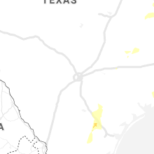
Hail Map for Sunday, April 7, 2019

Number of Impacted Households on 4/7/2019
0
Impacted by 1" or Larger Hail
0
Impacted by 1.75" or Larger Hail
0
Impacted by 2.5" or Larger Hail
Square Miles of Populated Area Impacted on 4/7/2019
0
Impacted by 1" or Larger Hail
0
Impacted by 1.75" or Larger Hail
0
Impacted by 2.5" or Larger Hail


Cities Most Affected by Hail Storms of 4/7/2019
| Hail Size | Demographics of Zip Codes Affected | ||||||
|---|---|---|---|---|---|---|---|
| City | Count | Average | Largest | Pop Density | House Value | Income | Age |
| Perry, MO | 2 | 1.75 | 1.75 | 10 | $64k | $34.3k | 48.9 |
| Lexington, MS | 1 | 2.00 | 2.00 | 20 | $48k | $16.3k | 35.2 |
| Camden, MS | 1 | 1.75 | 1.75 | 11 | $40k | $22.1k | 37.1 |
| Valhermoso Springs, AL | 1 | 1.75 | 1.75 | 42 | $63k | $41.6k | 43.9 |
| Monticello, AR | 1 | 1.75 | 1.75 | 42 | $64k | $29.2k | 35.3 |
Hail and Wind Damage Spotted on 4/7/2019
Filter by Report Type:Hail ReportsWind Reports
States Impacted
Texas, Arkansas, Louisiana, Mississippi, Alabama, Missouri, Tennessee, Iowa, Illinois, Indiana, FloridaTexas
| Local Time | Report Details |
|---|---|
| 7:08 AM CDT | Quarter sized hail reported near Marietta, TX, 58.6 miles NW of Shreveport, LA, quarter size hail fell about 10 miles northeast of hughes springs. report via facebook. |
| 7:10 AM CDT | Quarter sized hail reported near Douglassville, TX, 55.3 miles NW of Shreveport, LA, quarter size hail fell 6 miles north of linden. |
| 7:11 AM CDT | Half Dollar sized hail reported near Douglassville, TX, 54.9 miles NW of Shreveport, LA, a picture of half dollar size hail that fell in the red hill community was posted to facebook. |
| 7:15 AM CDT | Fire chief comfirms damage to fema trailers... some destroyed... at the old navy base east of the beeville prison. there was damage to the hanger roof as wel in bee county TX, 41.6 miles NNW of Corpus Christi, TX |
| 7:29 AM CDT | The bexar county office of emergency management relayed a report of downed trees at the intersection of montgomery drive and glen terrac in bexar county TX, 11 miles ENE of San Antonio, TX |
| 7:35 AM CDT | Gust of 63 mph measured at the beeville airport in bee county TX, 45.4 miles NNW of Corpus Christi, TX |
| 8:30 AM CDT | Multiple reports of downed powerlines on the south side of pharr. time estimated by rada in hidalgo county TX, 45.6 miles WNW of Brownsville, TX |
| 8:55 AM CDT | Mping report of broken tree limbs at the padre isles country clu in nueces county TX, 16.1 miles SE of Corpus Christi, TX |
| 9:10 AM CDT | Broken large tree branche in victoria county TX, 75.3 miles NNE of Corpus Christi, TX |
| 9:15 AM CDT | Wind gust of 73 mph was measured at the harlingen airpor in cameron county TX, 24.3 miles NNW of Brownsville, TX |
| 9:15 AM CDT | Broadcast media reported multiple downed trees between harlingen and combes along highway 77. time estimated by rada in cameron county TX, 25.8 miles NNW of Brownsville, TX |
| 9:20 AM CDT | Powerlines down on the southeast side of santa rosa in cameron county TX, 30.5 miles NW of Brownsville, TX |
| 9:30 AM CDT | Tree down blocking roadway in west harlingen in cameron county TX, 26.7 miles NNW of Brownsville, TX |
| 9:30 AM CDT | Fallen tree damaged a car on diaz street in san benito. photo submitted on social media. time estimated by rada in cameron county TX, 18.2 miles NNW of Brownsville, TX |
| 11:01 AM CDT | Wind gust measured at weatherflow xmgb sit in matagorda county TX, 88.6 miles SSW of Houston, TX |
| 12:17 PM CDT | Numerous reports of downed tree limbs in and around the bellaire and west university place (west 610 loop) are in harris county TX, 6.8 miles SW of Houston, TX |
| 12:24 PM CDT | Storm damage reported in brazos county TX, 87.1 miles ESE of Killeen, TX |
| 12:35 PM CDT | Street and business sign damage... along with tree damage in and around rice villag in harris county TX, 4.1 miles SW of Houston, TX |
| 12:50 PM CDT | Trees down across fm 2854 near keenan cutoff road southwest of lake conro in montgomery county TX, 42 miles NNW of Houston, TX |
| 12:53 PM CDT | Measured at weatherflow site xgpr in galveston county TX, 47.1 miles SE of Houston, TX |
| 1:35 PM CDT | 58mph recorded at kbpt in jefferson county TX, 14.8 miles SW of Beaumont, TX |
| 1:57 PM CDT | Picture of a tree across a power line near sour lake. time estimated by rada in hardin county TX, 39.9 miles W of Beaumont, TX |
| 2:05 PM CDT | Broadcast media relayed social media video showing damage in bevil oaks community. several trees snapped with some trees on houses. tree limbs and other debris scattere in jefferson county TX, 32.3 miles W of Beaumont, TX |
| 2:14 PM CDT | Public report and pictures of several large tree limbs down at a residence in beaumont. time estimated by rada in jefferson county TX, 24.2 miles W of Beaumont, TX |
| 2:14 PM CDT | Public picture of the top portion of a palm tree snapped at taco bell on college street in beaumon in jefferson county TX, 23.6 miles W of Beaumont, TX |
| 2:16 PM CDT | Public report of power poles broken along with 3 inch diameter tree limbs down south of lumberton. time estimated by rada in hardin county TX, 28.9 miles WNW of Beaumont, TX |
| 2:17 PM CDT | Small tree downed across power lines on 8th street in beauxart gardens. time estimated by rada in jefferson county TX, 20.4 miles WSW of Beaumont, TX |
| 2:25 PM CDT | Trained spotter sent pictures of road closed due to downed trees and power lines. location around the 1100 block of concord street in vidor. time estimated by rada in orange county TX, 15.3 miles W of Beaumont, TX |
| 2:57 PM CDT | Sheriff dispatch report of power lines down in the northern portion of jasper. time estimated by rada in jasper county TX, 51.2 miles ESE of Lufkin, TX |
| 3:32 PM CDT | Report of trees down on state highway 21 east of nacogdoches blocking all lanes of traffic. in the area of 16800 st hwy 21 e or cr 33 in nacogdoches county TX, 21.8 miles NE of Lufkin, TX |
| 4:00 PM CDT | Power lines down across fm181 in angelina county TX, 12.9 miles SSE of Lufkin, TX |
| 4:18 PM CDT | Powerlines across roadway cr 116& cr 11 in angelina county TX, 5.8 miles NNE of Lufkin, TX |
| 4:20 PM CDT | Power lines are reported down across fm 1818 in angelina county southeast of lukfi in angelina county TX, 6.4 miles SSE of Lufkin, TX |
Arkansas
| Local Time | Report Details |
|---|---|
| 8:10 AM CDT | Quarter sized hail reported near Hermitage, AR, 48.6 miles NNW of Bastrop, LA, received a report of 1" hail in hermitage via twitter picture. |
| 8:39 AM CDT | Quarter sized hail reported near Monticello, AR, 58.5 miles N of Bastrop, LA, received a picture of several 1" hailstones on the ground in monticello via facebook. |
| 8:40 AM CDT | Golf Ball sized hail reported near Monticello, AR, 58.5 miles N of Bastrop, LA, received a picture of golfball sized hail via twitter in monticello. |
| 10:52 AM CDT | Quarter sized hail reported near Benton, AR, 19.9 miles SW of Little Rock, AR, received reports of 1" diameter hail between benton and bauxite from mping and from trained storm spotters. |
| 10:55 AM CDT | Ping Pong Ball sized hail reported near Benton, AR, 21.3 miles SW of Little Rock, AR, received a few pictures of ping pong ball sized hail in benton via facebook. |
| 11:00 AM CDT | Quarter sized hail reported near Bryant, AR, 15.6 miles SW of Little Rock, AR, hail size ranged from dime to quarter size in twitter and facebook videos. |
| 11:02 AM CDT | Quarter sized hail reported near Bryant, AR, 12.9 miles SW of Little Rock, AR, hail size ranged from dime to quarter size in a photo posted to facebbok. |
| 2:20 PM CDT | Quarter sized hail reported near Mayflower, AR, 17.4 miles NNW of Little Rock, AR |
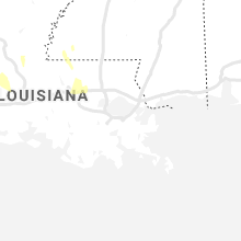
Louisiana
| Local Time | Report Details |
|---|---|
| 8:14 AM CDT | Eoc reported trees down in the montz area of st. charles parish... l in st. charles county LA, 23.7 miles W of New Orleans, LA |
| 8:14 AM CDT | Eoc reported power poles leaning near river road in norco in st. charles parish... l in st. john the bapti county LA, 29.1 miles W of New Orleans, LA |
| 1:50 PM CDT | Quarter sized hail reported near Oak Ridge, LA, 11.7 miles SE of Bastrop, LA, nickel to quarter size hail just north of oak ridge. |
| 2:10 PM CDT | Quarter sized hail reported near Marion, LA, 31.4 miles WNW of Bastrop, LA, corrects previous hail report from 11 ssw strong. corrects previous hail report from 11 ssw strong. public posts photo of hail covering the ground in the truxno communi |
| 2:31 PM CDT | Nws employee report of large tree down just north of train tracks along hwy 27 leading into dequincy. time estimated by rada in calcasieu county LA, 30.1 miles NE of Beaumont, TX |
| 2:35 PM CDT | Quarter sized hail reported near West Monroe, LA, 35.6 miles SSW of Bastrop, LA, corrects previous hail report from 11 ssw brownsville-bawcom. public send video of hail in the luna community via ktve-tv facebook page. |
| 3:15 PM CDT | Wind gust of 53kts reported at southland field airport asos - kux in calcasieu county LA, 21.5 miles E of Beaumont, TX |
| 3:45 PM CDT | Quarter sized hail reported near Farmerville, LA, 29.4 miles W of Bastrop, LA, public report hail via social media. |
| 4:15 PM CDT | Public post to social media of a tree blocking hwy 106 near bayou chicot. time estimated from rada in evangeline county LA, 45.8 miles NNW of Lafayette, LA |
| 4:45 PM CDT | Several trees dow in grant county LA, 92 miles SSW of Bastrop, LA |
| 4:50 PM CDT | Numerous trees dow in grant county LA, 90.5 miles SE of Shreveport, LA |
| 5:00 PM CDT | Home anemometer recorded 60mph wind gust. relayed by broadcast media. time estimated from rada in acadia county LA, 12.8 miles W of Lafayette, LA |
| 5:15 PM CDT | Multiple trees reported down across west part of the paris in grant county LA, 91.7 miles SE of Shreveport, LA |
| 5:18 PM CDT | Highway 71... north of hwy 158 trees down blocking roadwa in grant county LA, 90.1 miles SE of Shreveport, LA |
| 6:20 PM CDT | A tree was blown down on highway 909. wind gust was likely subsevere at this tim in concordia county LA, 79.3 miles N of Lafayette, LA |
| 6:25 PM CDT | Some trees were blown dow in franklin county LA, 44.1 miles SSE of Bastrop, LA |
| 6:35 PM CDT | A small tree was blown down in mangham and partially blocked a roa in richland county LA, 33.2 miles SSE of Bastrop, LA |
| 7:00 PM CDT | Public reported a damaged patio cover in port allen in west baton rouge... l in west baton rouge county LA, 50.8 miles ENE of Lafayette, LA |
| 7:00 PM CDT | Small tree limbs down less than 2 inches near intersection of perkins rd and bluebonnet r in east baton rouge county LA, 56.5 miles ENE of Lafayette, LA |
| 7:30 PM CDT | Emergency manager reported several power poles and power lines down on bayou gardens boulevard in bayou can in terrebonne county LA, 45.9 miles SW of New Orleans, LA |
| 7:30 PM CDT | It was reported that a tree fell on a house and powerlines are down near st. amant... la near la22/route 937 along rodgers a... b... and c crossroads.no injuries report in ascension county LA, 51.3 miles WNW of New Orleans, LA |
| 7:30 PM CDT | Multiple houses with major roof damage in st amant. possible tornad in ascension county LA, 51 miles WNW of New Orleans, LA |
| 7:45 PM CDT | Emergency manager reported a tree down on winfield bridge and coteau road and at 228 tudor street in terrebonne parish. no damages reporte in terrebonne county LA, 45.9 miles SW of New Orleans, LA |
| 7:59 PM CDT | Asos reported a wind gust of 51 knots from the west at port fourchon... l in gmz550 county LA, 63.4 miles S of New Orleans, LA |
| 8:14 PM CDT | Eoc reported trees down in the montz area of st. charles parish... l in st. charles county LA, 23.7 miles W of New Orleans, LA |
| 8:14 PM CDT | Eoc reported power poles leaning near river road in norco in st. charles parish... l in st. john the bapti county LA, 29.1 miles W of New Orleans, LA |
| 8:17 PM CDT | An emergency manager reported a tree down on a home in edgard in st. john the baptist paris in st. john the bapti county LA, 29.4 miles W of New Orleans, LA |
| 8:22 PM CDT | Power lines damaged near hickory and dickory avenues. time estimated by rada in jefferson county LA, 7.4 miles W of New Orleans, LA |
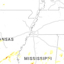
Mississippi
| Local Time | Report Details |
|---|---|
| 10:12 AM CDT | Measured at greenville mid-delta regional airpor in washington county MS, 72.2 miles NE of Bastrop, LA |
| 10:49 AM CDT | Power lines blown ove in sunflower county MS, 98.9 miles NNW of Jackson, MS |
| 1:05 PM CDT | A few trees down....power lines down and possible roof damag in calhoun county MS, 43.5 miles WNW of Starkville, MS |
| 1:17 PM CDT | Hen Egg sized hail reported near Lexington, MS, 57 miles N of Jackson, MS, multiple reports of golf ball to egg size hail in lexington. damage to vehicles also reported at the police station. |
| 2:45 PM CDT | Spotter report of 2 powerlines down on hatley r in monroe county MS, 42.4 miles NNE of Starkville, MS |
| 4:50 PM CDT | Golf Ball sized hail reported near Camden, MS, 38.4 miles NNE of Jackson, MS, social media report of golf ball sized hail near camden. |
| 5:10 PM CDT | Quarter sized hail reported near Woodville, MS, 74.1 miles NE of Lafayette, LA |
| 5:11 PM CDT | Public reported multiple trees down in pickneyville... ms in wilkinson county... m in wilkinson county MS, 66.7 miles NNE of Lafayette, LA |
| 6:32 PM CDT | Half Dollar sized hail reported near Louisville, MS, 27.2 miles SSW of Starkville, MS, social media report of half dollar sized hail in louisville. |
| 6:35 PM CDT | Half Dollar sized hail reported near Louisville, MS, 27.5 miles SSW of Starkville, MS |
| 6:54 PM CDT | Quarter sized hail reported near Lexington, MS, 57.1 miles N of Jackson, MS |
| 7:05 PM CDT | Trees and power lines were blown down both in the city of natchez and in the count in adams county MS, 87.4 miles SW of Jackson, MS |
| 7:53 PM CDT | Ping Pong Ball sized hail reported near Durant, MS, 57.2 miles NNE of Jackson, MS, durant pd reports ping pong ball sized hail. |
| 8:02 PM CDT | Tree down across the trac in claiborne county MS, 53.8 miles WSW of Jackson, MS |
Alabama
| Local Time | Report Details |
|---|---|
| 4:14 PM CDT | Half Dollar sized hail reported near Fayette, AL, 57.3 miles ENE of Starkville, MS |
| 4:14 PM CDT | Quarter sized hail reported near Somerville, AL, 54.8 miles ESE of Florence, AL, multiple reports of 1 inch hail in somerville. |
| 4:14 PM CDT | Ping Pong Ball sized hail reported near Fayette, AL, 57.3 miles ENE of Starkville, MS, corrects previous hail report from 2 ssw fayette. |
| 4:30 PM CDT | Golf Ball sized hail reported near Valhermoso Springs, AL, 58 miles ESE of Florence, AL, golf ball sized hail was reported in talucha. |
| 5:20 PM CDT | Quarter sized hail reported near Falkville, AL, 57.9 miles ESE of Florence, AL, quarter sized hail in oden ridge. |
| 6:06 PM CDT | Quarter sized hail reported near Parrish, AL, 27.1 miles WNW of Birmingham, AL |
| 6:29 PM CDT | Quarter sized hail reported near Quinton, AL, 22.6 miles WNW of Birmingham, AL |
| 5:48 AM CDT | Trees down on old scott road and williams settlement roa in blount county AL, 43.2 miles NNE of Birmingham, AL |
| 5:52 AM CDT | Trees down and damage to a mobile home near highway 79. possible tornad in blount county AL, 45.7 miles NNE of Birmingham, AL |
Missouri
| Local Time | Report Details |
|---|---|
| 4:52 PM CDT | Quarter sized hail reported near Bucklin, MO, 69.9 miles NNW of Columbia, MO |
| 4:54 PM CDT | Quarter sized hail reported near Bucklin, MO, 68.8 miles NNW of Columbia, MO |
| 5:12 PM CDT | Quarter sized hail reported near Ethel, MO, 67.9 miles WSW of Kahoka, MO, most hail 0.50 inch... largest stones up to size of quarters. |
| 6:55 PM CDT | Golf Ball sized hail reported near Perry, MO, 53 miles NE of Columbia, MO |
| 6:57 PM CDT | Quarter sized hail reported near Perry, MO, 50.7 miles NE of Columbia, MO |
| 6:59 PM CDT | Golf Ball sized hail reported near Perry, MO, 53.2 miles NE of Columbia, MO |
| 7:13 PM CDT | Quarter sized hail reported near Center, MO, 57.8 miles NE of Columbia, MO, hail is falling heavily. |
Tennessee
| Local Time | Report Details |
|---|---|
| 5:18 PM CDT | Half Dollar sized hail reported near Smithville, TN, 59 miles NNW of Chattanooga, TN, reported through media outlet in belk... tn. thanks to davis nolan. |
| 6:30 PM EDT | Multiple trees down around the bybee are in cocke county TN, 42.5 miles E of Knoxville, TN |
| 6:45 PM EDT | Ping Pong Ball sized hail reported near Midway, TN, 51.9 miles WSW of Bristol, TN |
Iowa
| Local Time | Report Details |
|---|---|
| 5:50 PM CDT | Quarter sized hail reported near Newton, IA, 28.4 miles ENE of Des Moines, IA |
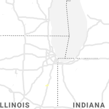
Illinois
| Local Time | Report Details |
|---|---|
| 6:28 PM CDT | Measured at chicago harrison-dever cri in lmz741 county IL, 4.1 miles NE of Chicago, IL |
| 8:10 PM CDT | All pea size hai in pike county IL, 67.2 miles NNW of Saint Louis, MO |
Indiana
| Local Time | Report Details |
|---|---|
| 10:14 PM EDT | Storm damage reported in tippecanoe county IN, 61 miles NW of Indianapolis, IN |
Florida
| Local Time | Report Details |
|---|---|
| 5:14 AM CDT | 63 mph wind gust measured at okaloosa island fishing pie in okaloosa county FL, 13.8 miles W of Miramar Beach, FL |
| 5:17 AM CDT | Storm damage reported in okaloosa county FL, 16.4 miles W of Miramar Beach, FL |
Connect with Interactive Hail Maps