

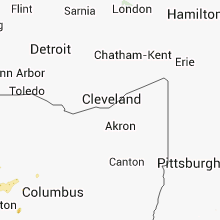
Hail Map for Wednesday, August 21, 2013

Number of Impacted Households on 8/21/2013
0
Impacted by 1" or Larger Hail
0
Impacted by 1.75" or Larger Hail
0
Impacted by 2.5" or Larger Hail
Square Miles of Populated Area Impacted on 8/21/2013
0
Impacted by 1" or Larger Hail
0
Impacted by 1.75" or Larger Hail
0
Impacted by 2.5" or Larger Hail


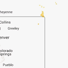

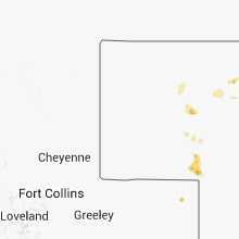


Cities Most Affected by Hail Storms of 8/21/2013
| Hail Size | Demographics of Zip Codes Affected | ||||||
|---|---|---|---|---|---|---|---|
| City | Count | Average | Largest | Pop Density | House Value | Income | Age |
| Newport, NE | 2 | 2.25 | 2.75 | 1 | $15k | $32.7k | 50.8 |
| Big Springs, NE | 2 | 1.75 | 1.75 | 2 | $47k | $29.3k | 49.5 |
| Menomonie, WI | 1 | 1.75 | 1.75 | 102 | $101k | $37.7k | 27.7 |
| Simpsonville, KY | 1 | 1.75 | 1.75 | 106 | $123k | $53.9k | 38.4 |
Hail and Wind Damage Spotted on 8/21/2013
Filter by Report Type:Hail ReportsWind Reports
States Impacted
Tennessee, Kentucky, Iowa, Georgia, Florida, Michigan, Minnesota, Wisconsin, Virginia, California, Alabama, Maryland, West Virginia, Nevada, NebraskaTennessee
| Local Time | Report Details |
|---|---|
| 11:33 AM CDT | Quarter sized hail reported near Carthage, TN, 47.3 miles E of Nashville, TN, quarter sized hail reported in carthage from trained spotter. |
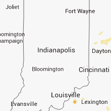
Kentucky
| Local Time | Report Details |
|---|---|
| 1:50 PM EDT | Metal roof blown off of a home on james roa in pulaski county KY, 46.5 miles SW of Irvine, KY |
| 3:40 PM EDT | Trees and power lines down in madison county KY, 19.2 miles WSW of Irvine, KY |
| 3:40 PM EDT | Tree down in madison county KY, 17.5 miles W of Irvine, KY |
| 3:49 PM EDT | One tree down on campbell hill road and one tree down on plummers street in wolfe county KY, 23.4 miles E of Irvine, KY |
| 5:15 PM EDT | Two trees down on peaks mill road in franklin county KY, 53.1 miles ENE of Louisville, KY |
| 6:10 PM EDT | Golf Ball sized hail reported near Simpsonville, KY, 25.6 miles NE of Louisville, KY |
| 6:10 PM EDT | Tree on a house in shelby county KY, 25.6 miles NE of Louisville, KY |
| 6:18 PM EDT | Quarter sized hail reported near Simpsonville, KY, 25.6 miles NE of Louisville, KY |
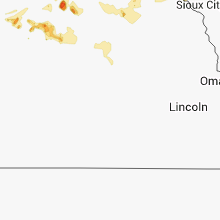
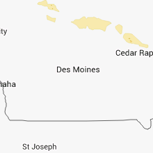
Iowa
| Local Time | Report Details |
|---|---|
| 1:13 PM CDT | Half Dollar sized hail reported near Ringsted, IA, 56.2 miles NE of Storm Lake, IA, trained spotter reported quarter to half dollar size hail |
| 5:04 AM CDT | The rwis at plainfield reported a gust to 51 knot in bremer county IA, 39.6 miles ESE of Mason City, IA |
| 5:05 AM CDT | Numerous large trees down in town. one large tree is down leaning on a house. time estimated by rada in bremer county IA, 39.6 miles ESE of Mason City, IA |
| 5:10 AM CDT | Numerous trees down and a machine shed severly damaged near horto in bremer county IA, 42.2 miles ESE of Mason City, IA |
| 6:23 AM CDT | Two trees down. one fell on power line in clayton county IA, 53.1 miles S of La Crosse, WI |
Georgia
| Local Time | Report Details |
|---|---|
| 2:35 PM EDT | Huge pecan tree down at 439 goodhope rd. several other trees down. one tree over a power line reported in lakeland. no injurie in lanier county GA, 38.3 miles SSW of Douglas, GA |
| 2:57 PM EDT | Several reports of trees down. one over power line in berrien county GA, 36.5 miles SW of Douglas, GA |
| 3:15 PM EDT | Tree down on auliegaskins r in berrien county GA, 35.1 miles SW of Douglas, GA |
| 5:15 PM EDT | Oglethorpe 911 relayed a report of two trees down in the carlton are in oglethorpe county GA, 60.8 miles SSW of Greenville, SC |
Florida
| Local Time | Report Details |
|---|---|
| 1:45 PM CDT | Large limbs snapped off several oak tree in washington county FL, 39.6 miles ENE of Miramar Beach, FL |
| 3:33 PM EDT | Mesonet station 3 sw eagle lake /ap837/ in polk county FL, 47.7 miles SSW of Orlando, FL |
| 3:48 PM EDT | Lakeland linder airport /lal/ reported 59 mph gust in polk county FL, 47.8 miles NE of Bradenton, FL |
| 3:52 PM EDT | Media report and photo of tree blown over on a house. time estimated by rada in polk county FL, 49.8 miles SW of Orlando, FL |
| 4:53 PM EDT | 13 damaged mobile homes along with several downed trees and lines in the holiday are in pasco county FL, 48.8 miles NNW of Bradenton, FL |
| 4:53 PM EDT | 4 mobile homes with roof damage so far...along with several downed trees and lines in the holiday are in pasco county FL, 48.8 miles NNW of Bradenton, FL |
| 5:17 PM EDT | Trained spotter reported power poles split at the tops for several blocks around south lake avenue and hardwood drive in clearwate in pinellas county FL, 32.8 miles NNW of Bradenton, FL |
| 5:17 PM EDT | Bay news 9 relayed reports of downed trees and damage to billboards in the fort harrison ave and belleair road area of clearwater. time estimated from rada in pinellas county FL, 33.5 miles NNW of Bradenton, FL |
| 5:20 PM EDT | Mesonet station 1 e belleair /xbla/ in pinellas county FL, 33.5 miles NNW of Bradenton, FL |
Michigan
| Local Time | Report Details |
|---|---|
| 4:00 PM EDT | Quarter sized hail reported near Marquette, MI, 11.9 miles ESE of Marquette, MI, quarter to dime sized hail fell for about 5 to 10 mins. |
| 4:09 PM EDT | Quarter sized hail reported near Marquette, MI, 11.9 miles ESE of Marquette, MI |
| 4:25 PM EDT | Several trees down. estimated one of the trees to have a 12-15 inch diameter. time estimated by rada in ontonagon county MI, 66.2 miles N of Rhinelander, WI |
| 5:03 PM EDT | Quarter sized hail reported near Grand Marais, MI, 68.8 miles E of Marquette, MI, mostly quarter sized hail. also mentioned there were a few flat hail stones that had the diameter of a golf ball. |
| 4:31 PM CDT | Quarter sized hail reported near Crystal Falls, MI, 52 miles ENE of Rhinelander, WI, some quarter sized hail with a lot of pea to dime sized hail. little wind. |
| 5:40 PM EDT | Quarter sized hail reported near Eben Junction, MI, 25.1 miles ESE of Marquette, MI, quarter sized hail. |
| 5:40 PM EDT | Half Dollar sized hail reported near Chatham, MI, 27.5 miles ESE of Marquette, MI, time estimated from radar. report via wluc tv facebook page. |
| 6:05 PM EDT | Quarter sized hail reported near Trenary, MI, 31.9 miles SE of Marquette, MI, several reports of dime and quarter sized hail. |
| 6:23 PM EDT | Quarter sized hail reported near Wetmore, MI, 41.4 miles SE of Marquette, MI, had two different storms that went through and both dropped quarter sized hail. first storm went through around 1805 edt...the second came through around 1823 edt. |
| 9:50 PM EDT | Reported from home weather station. covers blown off boats with no other damage reported from local broadcast medi in benzie county MI, 30.6 miles W of Traverse City, MI |
| 9:51 PM EDT | Scattered reports of trees and wires down throughout much of leelanau count in leelanau county MI, 19.1 miles WNW of Traverse City, MI |
| 11:30 PM EDT | Muskegon county road commission reports numerous trees down throughout county...mainly in fruitland and laketon townships. six to eight trees were large. time is approx in muskegon county MI, 42.1 miles NW of Grand Rapids, MI |
| 12:10 AM EDT | Ob taken from the port sheldon buoy in lmz846 county MI, 30.7 miles W of Grand Rapids, MI |
| 12:24 AM EDT | Few trees and branches reported down. relayed by wood tv in muskegon county MI, 32.7 miles WNW of Grand Rapids, MI |
| 12:24 AM EDT | Report of a tree down over s shore dr. courtesy of wood tv in muskegon county MI, 45.4 miles NW of Grand Rapids, MI |
| 12:36 AM EDT | Pine tree branches of about 4 inches in diameter broken from tree in allegan county MI, 20.3 miles SSW of Grand Rapids, MI |
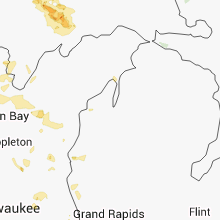
Minnesota
| Local Time | Report Details |
|---|---|
| 3:25 PM CDT | Quarter sized hail reported near Lakeville, MN, 22.7 miles S of Minneapolis, MN, at county road 50 and ipava ave |
| 4:07 PM CDT | Ping Pong Ball sized hail reported near Hastings, MN, 26.7 miles SE of Minneapolis, MN |
| 4:10 PM CDT | Quarter sized hail reported near Hastings, MN, 26.7 miles SE of Minneapolis, MN, time estimated |
| 4:50 AM CDT | Tree blown dow in brown county MN, 66.7 miles SE of Montevideo, MN |
| 6:45 AM CDT | 7-8 houses had trees blown down on northwest side of town. garage windows blown out and wooden fence blown over highway 14. time estimate in olmsted county MN, 50.3 miles WNW of La Crosse, WI |
| 6:45 AM CDT | Trees twisted with upper portions shredded. some trees blown completely down landing on power lines and house in olmsted county MN, 50.3 miles WNW of La Crosse, WI |
Wisconsin
| Local Time | Report Details |
|---|---|
| 3:40 PM CDT | Half Dollar sized hail reported near Rice Lake, WI, 81.2 miles ENE of Minneapolis, MN, hailed about five minutes. truck dented. some leaves stripped in nearby corn field. |
| 3:50 PM CDT | Quarter sized hail reported near Rice Lake, WI, 79.9 miles ENE of Minneapolis, MN, small branches also down. |
| 4:00 PM CDT | Quarter sized hail reported near Rice Lake, WI, 81.2 miles ENE of Minneapolis, MN |
| 4:15 PM CDT | Quarter sized hail reported near Cameron, WI, 79.9 miles ENE of Minneapolis, MN |
| 4:48 PM CDT | Tree down on building near campers at harbor campground. report via broadcat media wjfw-t in oneida county WI, 18.3 miles NE of Rhinelander, WI |
| 4:59 PM CDT | Golf Ball sized hail reported near Menomonie, WI, 66.7 miles E of Minneapolis, MN, hail observed from three quarters of an inch to golf ball noted in northern portion of city. |
| 5:35 PM CDT | Quarter sized hail reported near Argonne, WI, 25.8 miles E of Rhinelander, WI, report via broadcast media wsaw-tv |
| 5:45 PM CDT | Many small branches down. pea sized hai in clark county WI, 80.1 miles NNE of La Crosse, WI |
| 5:48 PM CDT | Trees down across road. reported by sherrif dept. time estimated by rada in lincoln county WI, 32 miles SW of Rhinelander, WI |
| 5:52 PM CDT | Large tree limb damaged house on north side of merril. reported by sherrif dept. time estimated by rada in lincoln county WI, 34.2 miles SSW of Rhinelander, WI |
| 6:13 PM CDT | Numerous trees down in the area of county road a and country road. time estimated by rada in marinette county WI, 63.5 miles N of Green Bay, WI |
| 6:45 PM CDT | Trees down in town of wagner. time estimate in marinette county WI, 58.3 miles NNE of Green Bay, WI |
| 6:55 PM CDT | Report via faceboo in oconto county WI, 32.3 miles N of Green Bay, WI |
| 7:10 PM CDT | Trees down from stockbridge indian reservation to gresham. time estimate in shawano county WI, 48.1 miles WNW of Green Bay, WI |
| 7:20 PM CDT | Several trees down west of tow in shawano county WI, 38.3 miles WNW of Green Bay, WI |
| 7:25 PM CDT | Trees dow in shawano county WI, 34 miles WNW of Green Bay, WI |
| 7:27 PM CDT | Trees down on 14th street. delayed report. time estimated by rada in waupaca county WI, 37.1 miles W of Green Bay, WI |
| 7:28 PM CDT | Storm damage reported in shawano county WI, 34 miles WNW of Green Bay, WI |
| 8:02 PM CDT | At nws green ba in brown county WI, 5 miles SW of Green Bay, WI |
| 8:32 PM CDT | Quarter sized hail reported near Waterford, WI, 63 miles ESE of Madison, WI, at bp station. |
| 8:50 PM CDT | Powerlines down at highway c/ in calumet county WI, 40.1 miles SSW of Green Bay, WI |
| 8:57 PM CDT | 4 foot diameter trees dow in calumet county WI, 39.2 miles S of Green Bay, WI |
Virginia
| Local Time | Report Details |
|---|---|
| 5:12 PM EDT | A tree was reported down on power lines on the 5500 block of singers glen roa in rockingham county VA, 57.4 miles ESE of Elkins, WV |
| 5:20 PM EDT | Couple of signs down near mile marker 264 along i-81 in shenandoah county VA, 65.6 miles ESE of Elkins, WV |
| 5:30 PM EDT | A tree was reported down blocking the southbound side of route 11 on the 16000 bloc in rockingham county VA, 65.8 miles ESE of Elkins, WV |
| 5:30 PM EDT | Large tree branch snappe in shenandoah county VA, 63.5 miles ESE of Elkins, WV |
| 5:57 PM EDT | A tree was reported down on power lines on the 5500 block of singers glen roa in rockingham county VA, 57 miles ESE of Elkins, WV |
| 6:14 PM EDT | Multiple large tree limbs and branches down along community center driv in rockingham county VA, 53.6 miles SE of Elkins, WV |
| 6:56 PM EDT | Two large tree limbs down on front street in richland in tazewell county VA, 41.8 miles NE of Bristol, TN |
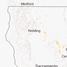
California
| Local Time | Report Details |
|---|---|
| 3:18 PM PDT | Quarter sized hail reported near , , 43.4 miles E of Redding, CA, a lot of 1" hail and heavy rain observed |
Alabama
| Local Time | Report Details |
|---|---|
| 5:55 PM CDT | Tree down near intersection of bristow cove rd and al hwy 179. time estimated from rada in etowah county AL, 54.6 miles NE of Birmingham, AL |
Maryland
| Local Time | Report Details |
|---|---|
| 7:04 PM EDT | Tree down on cabin run r in allegany county MD, 68.6 miles NE of Elkins, WV |
West Virginia
| Local Time | Report Details |
|---|---|
| 7:45 PM EDT | Tree down on route 71 in mercer county WV, 72.2 miles SSE of Charleston, WV |
| 8:00 PM EDT | Nws employee reports 3 ft diameter tree down. multiple trees in neighborhood down. power poles dow in kanawha county WV, 1.8 miles WSW of Charleston, WV |
| 8:09 PM EDT | Peak wind gust 61mph measured at tower not asos in kanawha county WV, 3 miles NE of Charleston, WV |
| 8:09 PM EDT | Peak wind gust 61mph measured by asos in kanawha county WV, 3 miles NE of Charleston, WV |
| 8:13 PM EDT | Tree down on old springs road in mercer county WV, 61.4 miles W of Roanoke, VA |
Nevada
| Local Time | Report Details |
|---|---|
| 5:00 PM PDT | Measured at the juniper springs raws. gust time estimate in washoe county NV, 82 miles SSE of Lakeview, OR |
| 5:02 PM PDT | Storm damage reported in elko county NV, 11 miles SE of Elko, NV |
| 6:00 PM PDT | Co-op observer estimated winds 60 mph causing some siding to come off a stru in elko county NV, 76.6 miles E of Elko, NV |
| 6:19 PM PDT | Pilot peak junction mesowest site measured a thunderstorm wind gust to 60 mp in elko county NV, 76.6 miles E of Elko, NV |
Nebraska
| Local Time | Report Details |
|---|---|
| 6:01 PM MDT | Quarter sized hail reported near Big Springs, NE, 72.5 miles W of North Platte, NE |
| 6:01 PM MDT | Quarter sized hail reported near Lewellen, NE, 74.3 miles W of North Platte, NE |
| 6:15 PM MDT | Storm damage reported in deuel county NE, 71.6 miles NNE of Yuma, CO |
| 7:22 PM CDT | Quarter sized hail reported near Bassett, NE, 48.4 miles WNW of Oneill, NE |
| 6:28 PM MDT | Golf Ball sized hail reported near Big Springs, NE, 71.6 miles NNE of Yuma, CO |
| 6:33 PM MDT | Golf Ball sized hail reported near Big Springs, NE, 71.6 miles NNE of Yuma, CO, all windows on north side of house broken out due to combination of large hail and strong wind gusts. |
| 7:44 PM CDT | Baseball sized hail reported near Newport, NE, 36.1 miles WNW of Oneill, NE |
| 6:45 PM MDT | Quarter sized hail reported near Big Springs, NE, 68.7 miles W of North Platte, NE, ground was white and covered in hail. |
| 7:50 PM CDT | Golf Ball sized hail reported near Newport, NE, 32.5 miles WNW of Oneill, NE, reported one window broken out. |
| 8:17 PM CDT | Quarter sized hail reported near Ainsworth, NE, 46.1 miles ESE of Valentine, NE |
| 8:33 PM CDT | Storm damage reported in holt county NE, 17.6 miles WNW of Oneill, NE |
| 9:00 PM CDT | 60 mph winds reported at estimated time of 9p in brown county NE, 55 miles WSW of Oneill, NE |
| 9:30 PM CDT | Estimated 60 mph wind gust around 930p in holt county NE, 9.2 miles NE of Oneill, NE |
| 10:40 PM CDT | Estimated 60 mph winds. tree fell over onto buildin in wheeler county NE, 35.7 miles SSE of Oneill, NE |
Connect with Interactive Hail Maps