

Hail Map for Saturday, August 28, 2021

Number of Impacted Households on 8/28/2021
0
Impacted by 1" or Larger Hail
0
Impacted by 1.75" or Larger Hail
0
Impacted by 2.5" or Larger Hail
Square Miles of Populated Area Impacted on 8/28/2021
0
Impacted by 1" or Larger Hail
0
Impacted by 1.75" or Larger Hail
0
Impacted by 2.5" or Larger Hail


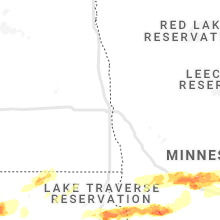


Cities Most Affected by Hail Storms of 8/28/2021
| Hail Size | Demographics of Zip Codes Affected | ||||||
|---|---|---|---|---|---|---|---|
| City | Count | Average | Largest | Pop Density | House Value | Income | Age |
| Milbank, SD | 2 | 2.13 | 2.50 | 30 | $67k | $32.6k | 45.2 |
| Salem, SD | 2 | 1.75 | 1.75 | 8 | $65k | $36.7k | 43.9 |
| Correll, MN | 1 | 2.75 | 2.75 | 3 | $36k | $25.0k | 49.6 |
| Danvers, MN | 1 | 2.75 | 2.75 | 3 | $53k | $42.2k | 43.7 |
| Waubay, SD | 1 | 2.50 | 2.50 | 5 | $30k | $26.5k | 39.9 |
| Larchwood, IA | 1 | 2.50 | 2.50 | 14 | $79k | $45.6k | 35.9 |
| Royalton, MN | 1 | 2.00 | 2.00 | 30 | $94k | $41.8k | 35.5 |
| Sauk Rapids, MN | 1 | 1.75 | 1.75 | 177 | $103k | $47.8k | 34.8 |
| Tracy, MN | 1 | 1.75 | 1.75 | 22 | $51k | $34.9k | 41.8 |
| Hills, MN | 1 | 1.75 | 1.75 | 23 | $65k | $38.3k | 40.7 |
Hail and Wind Damage Spotted on 8/28/2021
Filter by Report Type:Hail ReportsWind Reports
States Impacted
South Dakota, Minnesota, Michigan, Pennsylvania, Maryland, Virginia, West Virginia, Arizona, North Carolina, Nebraska, Iowa, WisconsinSouth Dakota
| Local Time | Report Details |
|---|---|
| 7:10 AM CDT | Quarter sized hail reported near Roscoe, SD, 36.1 miles WSW of Aberdeen, SD |
| 7:15 AM CDT | Quarter sized hail reported near Houghton, SD, 26.8 miles NNE of Aberdeen, SD |
| 7:33 AM CDT | Half Dollar sized hail reported near Milbank, SD, 50.6 miles WNW of Montevideo, MN, hailed for 5 to 10 minutes. |
| 8:08 AM CDT | Mesonet station 175 mellette (sddot in spink county SD, 20.7 miles S of Aberdeen, SD |
| 8:25 AM CDT | Quarter sized hail reported near Webster, SD, 53.6 miles ESE of Aberdeen, SD |
| 8:30 AM CDT | Tennis Ball sized hail reported near Waubay, SD, 56.4 miles ESE of Aberdeen, SD, radar estimated... relayed through facebook. |
| 8:44 AM CDT | Storm damage reported in grant county SD, 69.5 miles WNW of Montevideo, MN |
| 9:15 AM CDT | Tennis Ball sized hail reported near Milbank, SD, 51.7 miles WNW of Montevideo, MN, relayed through grant co em. |
| 9:19 AM CDT | Golf Ball sized hail reported near Milbank, SD, 48.8 miles WNW of Montevideo, MN |
| 9:35 AM CDT | Half Dollar sized hail reported near Big Stone City, SD, 44 miles WNW of Montevideo, MN |
| 9:44 AM CDT | Mesonet station 292 7ne milbank (sddot in grant county SD, 44.6 miles WNW of Montevideo, MN |
| 3:32 PM CDT | Quarter sized hail reported near Montrose, SD, 34.6 miles NW of Sioux Falls, SD, hail mostly dime to nickel sized... but some as big as quarters. also heavy rain. |
| 4:07 PM CDT | Corrects previous tstm wnd gst report from 6 wsw hurley. winds around 70 mph making the back of his pickup truck dance around. heavy rain and pea sized hail to in turner county SD, 30.7 miles SW of Sioux Falls, SD |
| 4:15 PM CDT | Quarter sized hail reported near Hurley, SD, 25.7 miles SW of Sioux Falls, SD, quarter sized hail. |
| 4:19 PM CDT | Wind gusts 60-70 mp in turner county SD, 25.7 miles SW of Sioux Falls, SD |
| 4:30 PM CDT | Report via social media of 2 semi trucks flipped over a little south of i-29 exit 6 in lincoln county SD, 11.9 miles SSW of Sioux Falls, SD |
| 4:40 PM CDT | Report via social media of tree damage in harrisbur in lincoln county SD, 8.1 miles S of Sioux Falls, SD |
| 4:45 PM CDT | Branches on cottonwood tree blown upward and off... landing on roof of hous in lincoln county SD, 8.9 miles SSE of Sioux Falls, SD |
| 6:55 PM CDT | Quarter sized hail reported near Harrisburg, SD, 8.1 miles S of Sioux Falls, SD, report from mping: quarter (1.00 in.). |
| 6:55 PM CDT | Quarter sized hail reported near Harrisburg, SD, 8 miles S of Sioux Falls, SD, report from mping: quarter (1.00 in.). |
| 6:58 PM CDT | Golf Ball sized hail reported near Salem, SD, 35.2 miles WNW of Sioux Falls, SD |
| 7:16 PM CDT | Quarter sized hail reported near Canton, SD, 17.4 miles SSE of Sioux Falls, SD, a few quarters... mostly nickel. |
| 7:20 PM CDT | Golf Ball sized hail reported near Salem, SD, 34 miles WNW of Sioux Falls, SD, report from social media... half dollar to golf ball size hail. |
| 7:50 PM CDT | Ping Pong Ball sized hail reported near Canistota, SD, 23.3 miles W of Sioux Falls, SD, report via social media from lake vermillion. |
Minnesota
| Local Time | Report Details |
|---|---|
| 7:53 AM CDT | Quarter sized hail reported near Ortonville, MN, 42.7 miles NW of Montevideo, MN, report relayed through social media. |
| 9:43 AM CDT | Mndot rwi in big stone county MN, 38.8 miles WNW of Montevideo, MN |
| 9:49 AM CDT | Report from mping: 1-inch tree limbs broken; shingles blown of in big stone county MN, 36.7 miles NW of Montevideo, MN |
| 9:57 AM CDT | Baseball sized hail reported near Correll, MN, 29 miles NW of Montevideo, MN, relayed through fb. |
| 10:24 AM CDT | Baseball sized hail reported near Danvers, MN, 24.1 miles N of Montevideo, MN, in addition to high winds and heavy rain. relayed via law enforcement. |
| 10:38 AM CDT | Storm damage reported in pope county MN, 51 miles NNE of Montevideo, MN |
| 10:40 AM CDT | Relayed report from grand forks nws from their facebook page... numerous large trees blown down along highway 29 near lake ren in pope county MN, 56.7 miles NNE of Montevideo, MN |
| 10:45 AM CDT | Reports of numerous 6 to 9 inch branches down... damage to mndot road signs... and damage to cornfield in pope county MN, 51.7 miles NNE of Montevideo, MN |
| 10:54 AM CDT | Half Dollar sized hail reported near Osakis, MN, 65.3 miles NNE of Montevideo, MN |
| 11:10 AM CDT | Numerous trees down in town with urban flooding time estimated via rada in stearns county MN, 65.8 miles NE of Montevideo, MN |
| 11:32 AM CDT | Emergency management reports 10 to 12 tree limbs down with time estimated based on rada in stearns county MN, 72.4 miles NW of Minneapolis, MN |
| 11:46 AM CDT | Quarter sized hail reported near Burtrum, MN, 80.1 miles NE of Montevideo, MN |
| 11:50 AM CDT | Ping Pong Ball sized hail reported near Sartell, MN, 63.9 miles NW of Minneapolis, MN, ping pong ball sized hail with estimated 58 mph winds. |
| 11:55 AM CDT | Ping Pong Ball sized hail reported near Sauk Rapids, MN, 61.1 miles NW of Minneapolis, MN, time estimated based on radar. |
| 11:58 AM CDT | Hen Egg sized hail reported near Royalton, MN, 77.7 miles NW of Minneapolis, MN |
| 12:00 PM CDT | Golf Ball sized hail reported near Sauk Rapids, MN, 61.6 miles NW of Minneapolis, MN, picture from social media with a half dollar and golf ball sized hail stone with time estimated based on radar. |
| 12:30 PM CDT | Quarter sized hail reported near Foreston, MN, 58.1 miles NNW of Minneapolis, MN, picture multiple hail stones up to the size of quarters. |
| 5:21 PM CDT | 4 to 6 inch diameter tree branches broken down by wind gust in murray county MN, 47.3 miles NE of Sioux Falls, SD |
| 5:23 PM CDT | Strong winds knocked trees down in the southern part of adria in nobles county MN, 40.6 miles E of Sioux Falls, SD |
| 5:30 PM CDT | Trees snapped by wind in murray county MN, 55.7 miles ENE of Sioux Falls, SD |
| 5:36 PM CDT | Machine shed damage in murray county MN, 60.9 miles ENE of Sioux Falls, SD |
| 5:44 PM CDT | Storm damage reported in murray county MN, 56.6 miles ENE of Sioux Falls, SD |
| 5:45 PM CDT | Report via social media of heavy tree damage in avoc in murray county MN, 60.9 miles ENE of Sioux Falls, SD |
| 5:46 PM CDT | Grain bin damaged 1/2 mile south of westbrook. damage also to old barn 1 south of westbroo in cottonwood county MN, 65.2 miles SSE of Montevideo, MN |
| 5:50 PM CDT | Damage to westbrook lumber building. wind gusts estimated at 70 mp in cottonwood county MN, 64.5 miles SSE of Montevideo, MN |
| 5:54 PM CDT | Grain bin damage 1/2 mile south of storde in cottonwood county MN, 66.6 miles SSE of Montevideo, MN |
| 5:58 PM CDT | Report via social media of tree damage east of slayto in murray county MN, 58.8 miles ENE of Sioux Falls, SD |
| 6:06 PM CDT | Report from mping: trees uprooted or snapped; roof blown of in cottonwood county MN, 80.3 miles SSE of Montevideo, MN |
| 6:16 PM CDT | Numerous trees down and laying across roa in cottonwood county MN, 68.6 miles SSE of Montevideo, MN |
| 6:20 PM CDT | Large tree uprooted. pic sent via twitte in brown county MN, 70.8 miles SE of Montevideo, MN |
| 6:20 PM CDT | Large tree snapped and smaller trees down. pics sent via twitte in brown county MN, 67.4 miles SE of Montevideo, MN |
| 6:46 PM CDT | Wind damage/trees down south part of sleepy ey in brown county MN, 66.3 miles SE of Montevideo, MN |
| 6:50 PM CDT | Trees down in st. jame in watonwan county MN, 85.8 miles SE of Montevideo, MN |
| 6:50 PM CDT | Trees down in sveadah in watonwan county MN, 77.2 miles SE of Montevideo, MN |
| 6:58 PM CDT | Report from mping: 1-inch tree limbs broken; shingles blown of in brown county MN, 70.8 miles SE of Montevideo, MN |
| 7:45 PM CDT | Photo on twitter of a mature tree down. broke off several feet above its base. time estimated from rada in nicollet county MN, 72.2 miles SW of Minneapolis, MN |
| 8:08 PM CDT | Golf Ball sized hail reported near Hills, MN, 18.7 miles E of Sioux Falls, SD, report via social media. |
| 8:21 PM CDT | Golf Ball sized hail reported near Tracy, MN, 56.8 miles S of Montevideo, MN, lots of golf ball sized hail and heavy rainfall 3.40 inches so far. |
Michigan
| Local Time | Report Details |
|---|---|
| 1:55 PM EDT | Multiple trees down in south boardman. pics sent via social media. time estimated based on rada in kalkaska county MI, 18.5 miles ESE of Traverse City, MI |
| 1:55 PM EDT | Multiple trees down near albright swamp. social media pictures show one tree down on top of a hous in kalkaska county MI, 18.8 miles ESE of Traverse City, MI |
| 3:10 PM EDT | County dispatch reports multiple trees down across roscommon count in roscommon county MI, 48.1 miles ESE of Traverse City, MI |
| 4:30 PM EDT | Ogemaw county dispatch reports numerous areas with trees downs and power outages... including peach lake/w finerty r in ogemaw county MI, 64.1 miles SW of Alpena, MI |
| 5:01 PM EDT | Iosco county dispatch reports trees down near sand lak in iosco county MI, 52.5 miles SSW of Alpena, MI |
| 5:15 PM EDT | Iosco county dispatch reports trees down near whittemor in iosco county MI, 60 miles SSW of Alpena, MI |
| 5:25 PM EDT | County dispatch reports trees down in tawas cit in iosco county MI, 54.8 miles S of Alpena, MI |
| 5:33 PM EDT | Trees down. time estimated from rada in bay county MI, 68.9 miles NNW of Flint, MI |
| 5:58 PM EDT | Tree on hous in gratiot county MI, 58.3 miles WNW of Flint, MI |
| 6:02 PM EDT | We energies outage affecting 69 customers east of lake michigamme occurred at 6:02 pm. state police dispatch also reports a tree down in the are in marquette county MI, 29.5 miles W of Marquette, MI |
| 6:08 PM EDT | Trees down including some metal roofing blown off a barn. social media image consistent with microburst damage. time estimated by rada in saginaw county MI, 42.3 miles NW of Flint, MI |
| 6:13 PM EDT | Quarter sized hail reported near Alma, MI, 53.2 miles WNW of Flint, MI, quarter size hail at n state road and w lincoln road. |
| 6:16 PM EDT | Measured at kmbs airpor in saginaw county MI, 30.7 miles NW of Flint, MI |
| 6:16 PM EDT | Measured at kmbs airport - corrected locatio in saginaw county MI, 41 miles NNW of Flint, MI |
| 6:20 PM EDT | A marine thunderstorm wind gust of 78 mph... 68 knots... measured at gravelly shoal light. gusts of over 60 knots occurred for at least 20 straight minutes - corrected in lhz421 county MI, 70.1 miles N of Flint, MI |
| 6:20 PM EDT | A marine thunderstorm wind gust of 78 mph... 68 knots... measured at gravelly shoal ligh in lhz421 county MI, 68.4 miles N of Flint, MI |
| 6:20 PM EDT | A marine thunderstorm wind gust of 78 mph... 68 knots... measured at gravelly shoal ligh in lhz421 county MI, 68.4 miles N of Flint, MI |
| 6:20 PM EDT | County dispatch reported multiple boats were overturned due to strong marine thunderstorm winds in caseville...port austin...and port hope. time of report corresponds t in huron county MI, 67.5 miles NNE of Flint, MI |
| 6:20 PM EDT | County dispatch reported multiple boats were overturned due to strong marine thunderstorm winds in caseville...port austin...and port hope. time of report corresponds t in huron county MI, 67.5 miles NNE of Flint, MI |
| 6:22 PM EDT | Several trees down near hospital rd and mccarty r in saginaw county MI, 36.6 miles NNW of Flint, MI |
| 6:30 PM EDT | Multiple power lines down. time estimated by rada in huron county MI, 73.9 miles SSE of Alpena, MI |
| 6:36 PM EDT | Trees down all along m 46 and in breckenridge... m in gratiot county MI, 48.6 miles NW of Flint, MI |
| 6:36 PM EDT | Tree on hous in gratiot county MI, 47 miles NW of Flint, MI |
| 6:37 PM EDT | Multiple trees down. time estimated by rada in saginaw county MI, 31.2 miles NNW of Flint, MI |
| 6:38 PM EDT | Trees and power lines down in and east of wheeler... especially at the intersection of m 46 and north mason road and m 46 and north barry roa in gratiot county MI, 45 miles NW of Flint, MI |
| 6:39 PM EDT | Awos station kamn alm in gratiot county MI, 54.6 miles WNW of Flint, MI |
| 6:44 PM EDT | Trees down. time estimated from rada in bay county MI, 41.3 miles NNW of Flint, MI |
| 6:47 PM EDT | Multiple power lines down. time estimated by rada in huron county MI, 80.5 miles NE of Flint, MI |
| 6:54 PM EDT | Trees and wires down along m 46 near meridian roa in gratiot county MI, 44.2 miles NW of Flint, MI |
| 7:40 PM EDT | Report of a tree on a power line... power line smoking. details unknow in marquette county MI, 8 miles SW of Marquette, MI |
Pennsylvania
| Local Time | Report Details |
|---|---|
| 2:25 PM EDT | Multiple trees down blocking roadwa in clearfield county PA, 26.5 miles W of State College, PA |
Maryland
| Local Time | Report Details |
|---|---|
| 3:40 PM EDT | Several trees and wires blew down near la vale and corriganvill in allegany county MD, 76.5 miles NE of Elkins, WV |
| 4:03 PM EDT | Tree and wires down on mount savage road near md-638 parkersburg road northwes in allegany county MD, 72.7 miles NE of Elkins, WV |
| 4:28 PM EDT | Tree branches and wires down on concord stree in washington county MD, 65.3 miles WNW of Baltimore, MD |
Virginia
| Local Time | Report Details |
|---|---|
| 4:37 PM EDT | Tree down in the 1100 block of north frederick pik in city of winchester county VA, 84.1 miles W of Baltimore, MD |
| 5:13 PM EDT | Tree down in the 5600 block of mountain turnpik in highland county VA, 35.2 miles SSE of Elkins, WV |
| 6:23 PM EDT | Tree down on zachary taylor highway near hittles mill roa in rappahannock county VA, 87.3 miles WSW of Baltimore, MD |
| 6:24 PM EDT | Tree down on fodderstack road near dearing roa in rappahannock county VA, 89.1 miles WSW of Baltimore, MD |
| 6:24 PM EDT | Two trees down on zachary taylor highway near flint hil in rappahannock county VA, 88.2 miles WSW of Baltimore, MD |
| 6:29 PM EDT | Tree down on old mill road near warren av in rappahannock county VA, 87.7 miles NNW of Richmond, VA |
| 6:48 PM EDT | Three trees down on richmond roa in rappahannock county VA, 84.4 miles NNW of Richmond, VA |
| 6:52 PM EDT | Three trees down in mt solo in augusta county VA, 57.4 miles SE of Elkins, WV |
| 6:52 PM EDT | Tree down on overly hollow road near bergton roa in rockingham county VA, 51.4 miles E of Elkins, WV |
| 6:59 PM EDT | Tree down on castleton view road near county road 61 in rappahannock county VA, 80.3 miles NNW of Richmond, VA |
| 7:01 PM EDT | Tree down on moffet branch road near dudley farm roa in augusta county VA, 61 miles SE of Elkins, WV |
| 7:25 PM EDT | Two trees down in calverto in fauquier county VA, 73.1 miles SW of Baltimore, MD |
| 7:30 PM EDT | Several trees down in midlan in fauquier county VA, 75.7 miles N of Richmond, VA |
| 7:30 PM EDT | Large tree down at the intersection of route 29 and greens corner roa in culpeper county VA, 68.6 miles NNW of Richmond, VA |
| 7:52 PM EDT | Trees and branches down in morrisvill in fauquier county VA, 68.8 miles N of Richmond, VA |
| 7:52 PM EDT | Tree down on union church roa in fauquier county VA, 66.1 miles N of Richmond, VA |
| 7:52 PM EDT | Tree and wires down on maryland avenue near 6th stree in page county VA, 72.6 miles ESE of Elkins, WV |
| 7:52 PM EDT | Tree down on shenandoah river road near junior av in page county VA, 72.1 miles ESE of Elkins, WV |
| 7:59 PM EDT | Tree and wires down on garage lane near s e side highwa in rockingham county VA, 71.9 miles SE of Elkins, WV |
| 8:01 PM EDT | Tree down near piney hill road near piney woods roa in page county VA, 74.9 miles ESE of Elkins, WV |
| 8:11 PM EDT | Tree branches and wires down in elkto in rockingham county VA, 75.1 miles ESE of Elkins, WV |
| 8:11 PM EDT | Wires down in the 100 block of eden roa in page county VA, 79 miles ESE of Elkins, WV |
| 8:18 PM EDT | Multiple reports of trees and wires down throughout culpeper count in culpeper county VA, 61.8 miles N of Richmond, VA |
| 8:30 PM EDT | 10 trees down on clarks mountain rd. just east of rapide in orange county VA, 57.7 miles NNW of Richmond, VA |
| 9:03 PM EDT | Tree down on turkey sag road near gordonsville roa in albemarle county VA, 53.1 miles NW of Richmond, VA |
| 9:03 PM EDT | Powerlines down on greenleaf lan in albemarle county VA, 59 miles NW of Richmond, VA |
| 9:30 PM EDT | Tree down across louisa roa in louisa county VA, 43.5 miles NNW of Richmond, VA |
| 9:40 PM EDT | Tree downed... blocking us-250. time estimated by rada in goochland county VA, 34.1 miles NW of Richmond, VA |
| 9:45 PM EDT | Tree downed over davis highway. time estimated by rada in louisa county VA, 38.3 miles NNW of Richmond, VA |
West Virginia
| Local Time | Report Details |
|---|---|
| 4:59 PM EDT | Tree down on overlook trail driv in morgan county WV, 91.4 miles ENE of Elkins, WV |
| 5:17 PM EDT | Tree down on arden nollville road near applewood driv in berkeley county WV, 76.8 miles W of Baltimore, MD |
| 5:27 PM EDT | Tree branches down on logans run driv in jefferson county WV, 75.1 miles W of Baltimore, MD |
| 6:38 PM EDT | Branches and wires down in and near maysvill in grant county WV, 38.7 miles ENE of Elkins, WV |
Arizona
| Local Time | Report Details |
|---|---|
| 3:40 PM MST | Power pole down at houghton rd at dawn r in pima county AZ, 17.7 miles SE of Tucson, AZ |
| 6:27 PM MST | Delayed report. downed power pole kearny water wells-airport rd & camino rio rd-hammond dr. time estimated from rada in pinal county AZ, 57.2 miles N of Tucson, AZ |
North Carolina
| Local Time | Report Details |
|---|---|
| 6:57 PM EDT | Tree downed across harvey point road. time estimated by rada in perquimans county NC, 47.9 miles SSW of Virginia Beach, VA |
Nebraska
| Local Time | Report Details |
|---|---|
| 6:35 PM CDT | Ping Pong Ball sized hail reported near Stapleton, NE, 28.5 miles NNE of North Platte, NE |
| 7:33 PM CDT | Estimated 4 inch tree limb dow in wheeler county NE, 32.3 miles S of Oneill, NE |
| 7:35 PM CDT | Half Dollar sized hail reported near Burwell, NE, 51.6 miles SW of Oneill, NE |
| 9:00 PM CDT | Norfolk airport asos measured a peak wind gust of 59 mp in madison county NE, 69.9 miles ESE of Oneill, NE |
| 9:01 PM CDT | Trained spotter estimated peak wind gust of 60 mp in madison county NE, 67.9 miles ESE of Oneill, NE |
| 9:11 PM CDT | Corrects previous report from kofk to update wind speed and time. norfolk airport asos measured a peak wind gust of 61 mp in madison county NE, 69.9 miles ESE of Oneill, NE |
| 9:12 PM CDT | Storm damage reported in madison county NE, 69.9 miles ESE of Oneill, NE |
| 9:25 PM CDT | Minor tree damage. 3 to 4 inch limbs dow in stanton county NE, 72 miles ESE of Oneill, NE |
| 9:30 PM CDT | 6 to 8 inch limbs down across southern stanton count in stanton county NE, 75.7 miles WNW of Omaha, NE |
Iowa
| Local Time | Report Details |
|---|---|
| 7:35 PM CDT | Quarter sized hail reported near Inwood, IA, 17 miles SE of Sioux Falls, SD, mostly pea-sized hail for about 5 minutes... largest hail stones were quarter sized. |
| 7:48 PM CDT | Tennis Ball sized hail reported near Larchwood, IA, 15.3 miles ESE of Sioux Falls, SD |
| 8:12 PM CDT | Report from mping: 3-inch tree limbs broken; power poles broke in lyon county IA, 20.2 miles ESE of Sioux Falls, SD |
Wisconsin
| Local Time | Report Details |
|---|---|
| 2:21 AM CDT | Chippewa valley airport asos measured a 59 mph gus in chippewa county WI, 73.9 miles N of La Crosse, WI |
Connect with Interactive Hail Maps