

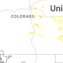
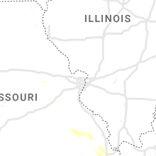
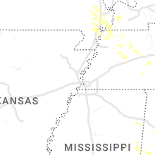
Hail Map for Thursday, August 3, 2023

Number of Impacted Households on 8/3/2023
0
Impacted by 1" or Larger Hail
0
Impacted by 1.75" or Larger Hail
0
Impacted by 2.5" or Larger Hail
Square Miles of Populated Area Impacted on 8/3/2023
0
Impacted by 1" or Larger Hail
0
Impacted by 1.75" or Larger Hail
0
Impacted by 2.5" or Larger Hail


Cities Most Affected by Hail Storms of 8/3/2023
| Hail Size | Demographics of Zip Codes Affected | ||||||
|---|---|---|---|---|---|---|---|
| City | Count | Average | Largest | Pop Density | House Value | Income | Age |
| Kersey, CO | 2 | 1.75 | 1.75 | 14 | $132k | $47.9k | 36.9 |
| Whitney, NE | 1 | 1.75 | 1.75 | 1 | $39k | $30.7k | 49.5 |
Hail and Wind Damage Spotted on 8/3/2023
Filter by Report Type:Hail ReportsWind Reports
States Impacted
Alabama, Tennessee, Wisconsin, Nevada, New York, Michigan, Georgia, Oregon, South Carolina, Colorado, Mississippi, Utah, Vermont, Nebraska, Wyoming, South Dakota, KansasAlabama
| Local Time | Report Details |
|---|---|
| 12:33 PM CDT | Corrects previous tstm wnd dmg report from 7 wsw flint city. reports of trees down and road blockage in the eva area of morgan count in morgan county AL, 39.5 miles SE of Florence, AL |
| 1:12 PM CDT | Trees were reported down across across the entire count in cullman county AL, 45.5 miles N of Birmingham, AL |
| 1:18 PM CDT | Corrects previous tstm wnd dmg report from 6 n baileyton. trees down at the apple grove road auction house. roadway is blocked at this tim in morgan county AL, 57.7 miles NNE of Birmingham, AL |
| 1:19 PM CDT | Several trees reported down densmore rd/apple grove r in morgan county AL, 59 miles N of Birmingham, AL |
| 1:20 PM CDT | Significant damage to a house and barn was reported off of densmore near hog jaw roa in morgan county AL, 57.9 miles NNE of Birmingham, AL |
| 1:25 PM CDT | Corrects previous tstm wnd dmg report from 4 w arab. reports of trees down at the intersection of midfield rd and mat morrow rd in marshall county a in marshall county AL, 57.6 miles NNE of Birmingham, AL |
| 1:37 PM CDT | Trees down at the apple grove road auction house. roadway is blocked at this tim in morgan county AL, 57.7 miles NNE of Birmingham, AL |
| 1:53 PM CDT | Corrects previous tstm wnd dmg report from 2 nw douglas. reports of trees down on bethleham rd in marshall county a in marshall county AL, 53.2 miles NNE of Birmingham, AL |
| 1:55 PM CDT | Corrects previous tstm wnd dmg report from 2 wsw douglas. reports of trees down at the intersection of concord rd and highway 75 in marshall county a in marshall county AL, 51.5 miles NNE of Birmingham, AL |
| 1:57 PM CDT | Trees blown down in the curry are in walker county AL, 38 miles NW of Birmingham, AL |
| 2:01 PM CDT | Several trees reported down in the mount hebron area near douglas. some trees fell on house in marshall county AL, 52.2 miles NE of Birmingham, AL |
| 2:03 PM CDT | A few trees blown down in the oneonta are in blount county AL, 35.2 miles NNE of Birmingham, AL |
| 2:09 PM CDT | Trees down in the walnut grove are in etowah county AL, 48 miles NE of Birmingham, AL |
| 2:10 PM CDT | Reports of trees down and road blockage in the eva area of morgan count in morgan county AL, 39.5 miles SE of Florence, AL |
| 2:15 PM CDT | Trees down in the egypt communit in etowah county AL, 53.7 miles NE of Birmingham, AL |
| 2:21 PM CDT | Multiple trees down in various parts of the county including reece city... sand valley... gadsden and lookout mountain. some trees downed onto residences and vehicle in etowah county AL, 57.9 miles NE of Birmingham, AL |
| 2:22 PM CDT | Reports of trees down at the intersection of concord rd and highway 75 in marshall county a in marshall county AL, 51.5 miles NNE of Birmingham, AL |
| 2:22 PM CDT | Reports of trees down at the intersection of midfield rd and mat morrow rd in marshall county a in marshall county AL, 57.6 miles NNE of Birmingham, AL |
| 2:22 PM CDT | Reports of trees down on bethleham rd in marshall county a in marshall county AL, 53.2 miles NNE of Birmingham, AL |
| 2:23 PM CDT | Large pine tree fell... destroying hous in etowah county AL, 58.4 miles NE of Birmingham, AL |
| 2:28 PM CDT | *** 10 inj *** multiple trees uprooted and snapped on tabor rd. trees on homes... vehicles... and tents for an outdoor even in etowah county AL, 63.2 miles NE of Birmingham, AL |
| 2:33 PM CDT | Trees down in various parts of the count in walker county AL, 34.4 miles NW of Birmingham, AL |
| 2:40 PM CDT | Trees down on cr 4 in fayette county AL, 58.4 miles WNW of Birmingham, AL |
| 2:45 PM CDT | Large tree down on union grove road. motorist hit the tree causing an injur in jefferson county AL, 11.4 miles WNW of Birmingham, AL |
| 2:55 PM CDT | Trees down on highway 18 eas in fayette county AL, 58.6 miles W of Birmingham, AL |
| 3:00 PM CDT | A few trees down in various parts of the count in calhoun county AL, 63.6 miles ENE of Birmingham, AL |
| 3:13 PM CDT | Trees blown down in concord are in jefferson county AL, 13.6 miles WSW of Birmingham, AL |
| 3:18 PM CDT | A few trees down on cr 66 and ross street near heflin. time estimated by rada in cleburne county AL, 68.7 miles W of Atlanta, GA |
| 3:46 PM CDT | Tree fell and sliced a mobile/manufactured home in hal in shelby county AL, 21 miles S of Birmingham, AL |
| 4:00 PM CDT | Trees down in various locations east of tuscaloos in tuscaloosa county AL, 43.4 miles WSW of Birmingham, AL |
| 4:04 PM CDT | Multiple trees and power lines dow in shelby county AL, 29.2 miles S of Birmingham, AL |
| 4:30 PM CDT | Several trees down in stansel. photos on social media of uprooted and snapped trees. time estimated by rada in pickens county AL, 45.8 miles ESE of Starkville, MS |
| 4:36 PM CDT | Trees and power lines dow in tallapoosa county AL, 37.3 miles NW of Auburn, AL |
| 4:38 PM CDT | Multiple trees down north of highway 2 in tallapoosa county AL, 36.3 miles NW of Auburn, AL |
| 4:40 PM CDT | Numerous trees down on preserve dr. time estimated by rada in coosa county AL, 51.2 miles SSE of Birmingham, AL |
| 4:49 PM CDT | Multiple trees dow in elmore county AL, 49.4 miles W of Auburn, AL |
| 4:54 PM CDT | Several trees dow in tallapoosa county AL, 27.2 miles NW of Auburn, AL |
| 5:19 PM CDT | Trees down in various parts of the count in elmore county AL, 42.3 miles W of Auburn, AL |
| 5:30 PM CDT | Tree down in lanett near hwy 50. time estimated by rada in chambers county AL, 23.4 miles NE of Auburn, AL |
| 5:39 PM CDT | Corrects previous non-tstm wnd gst report from martin dam to tstm wind gst. baron statio in elmore county AL, 25.5 miles WNW of Auburn, AL |
| 5:44 PM CDT | Weatherstem station atop university bookstor in lee county AL, 0.7 miles SW of Auburn, AL |
| 5:54 PM CDT | Trees down on cr 7. time estimated by rada in bullock county AL, 35.5 miles SW of Auburn, AL |
| 5:54 PM CDT | Tree down across i-85 and nearby county roads. time estimated by rada in macon county AL, 23.9 miles WSW of Auburn, AL |
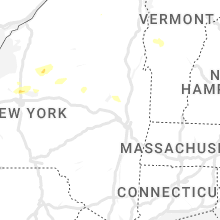
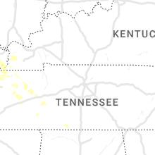
Tennessee
| Local Time | Report Details |
|---|---|
| 2:20 PM EDT | Trees and power lines down near hwy 70 (kingston hwy) and copenhaver r in roane county TN, 26.2 miles WSW of Knoxville, TN |
| 2:30 PM EDT | Trees down and roof damage to a few home in loudon county TN, 22.4 miles WSW of Knoxville, TN |
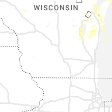
Wisconsin
| Local Time | Report Details |
|---|---|
| 2:35 PM CDT | Thunderstorm winds produced wind damage to a birch tree and pea size hail. time is an estimate based on radar imager in brown county WI, 5.6 miles ENE of Green Bay, WI |
| 3:10 PM CDT | Multiple trees down. via social medi in brown county WI, 14.9 miles SE of Green Bay, WI |
| 3:17 PM CDT | Multiple trees down just north of cit in door county WI, 38 miles NE of Green Bay, WI |
| 4:04 PM CDT | Corrects previous non-tstm wnd gst report from 3 n manitowoc. awos station kmtw manitowoc airpor in manitowoc county WI, 31.9 miles SSE of Green Bay, WI |
| 4:09 PM CDT | Quarter sized hail reported near Manitowoc, WI, 33.1 miles SSE of Green Bay, WI |
| 4:09 PM CDT | Thunderstorm winds downed numerous trees in manitowoc. the time of this report is an estimate based on radar data. estimated wind speed 70 mp in manitowoc county WI, 32.8 miles SSE of Green Bay, WI |
| 4:09 PM CDT | Thunderstorm winds downed numerous trees in manitowoc. the time of this report is an estimate based on radar data. estimated wind speed 70 mp in manitowoc county WI, 32.9 miles SSE of Green Bay, WI |
| 4:10 PM CDT | Multiple reports of trees down in the city of manitowoc. time of this report is an estimate based on radar dat in manitowoc county WI, 33.4 miles SSE of Green Bay, WI |
| 5:20 PM CDT | Multiple trees and powerlines down. royal st. patrick golf clubhouse had its roof blown of in brown county WI, 14.6 miles SSW of Green Bay, WI |
| 6:30 PM CDT | Trees and powerlines down in neena in winnebago county WI, 31.3 miles SW of Green Bay, WI |
| 6:30 PM CDT | Corrects previous tstm wnd dmg report from neenah. trees and powerlines down in neena in winnebago county WI, 32 miles SW of Green Bay, WI |
| 6:36 PM CDT | Quarter sized hail reported near Kiel, WI, 40.9 miles S of Green Bay, WI, report from mping: quarter (1.00 in.). |
| 6:45 PM CDT | Numerous trees down in elkhart lak in sheboygan county WI, 46.5 miles S of Green Bay, WI |
| 6:55 PM CDT | 3-inch tree limbs and power poles broke in fond du lac county WI, 58.4 miles SSW of Green Bay, WI |
| 7:05 PM CDT | 3 trees and power lines dow in fond du lac county WI, 48.4 miles S of Green Bay, WI |
| 7:17 PM CDT | Multiple 8" diameter branches down... 3/4" hail... and street flooding at murdock ave near lake winnebag in winnebago county WI, 43.8 miles SW of Green Bay, WI |
| 7:20 PM CDT | Multiple trees and powerlines down in the town of black wol in winnebago county WI, 47.2 miles SW of Green Bay, WI |
| 7:55 PM CDT | Public report with time from spotter submitted with online form. tree branches down as well as power outages. no visual verification availabl in fond du lac county WI, 61.6 miles S of Green Bay, WI |
Nevada
| Local Time | Report Details |
|---|---|
| 12:43 PM PDT | Martin creek raws (mpvn2)... elevation 6439 fee in humboldt county NV, 53.6 miles NNE of Winnemucca, NV |
| 3:47 PM PDT | Mesonet station mjbn2 majub in pershing county NV, 43.4 miles WSW of Winnemucca, NV |
New York
| Local Time | Report Details |
|---|---|
| 3:48 PM EDT | One tree down near clifton park cente in saratoga county NY, 9 miles ENE of Schenectady, NY |
| 3:50 PM EDT | Tree dow in saratoga county NY, 8.2 miles NE of Schenectady, NY |
| 5:43 PM EDT | Powerlines down on youngs rd in westpor in essex county NY, 22.4 miles SW of Burlington, VT |
| 5:50 PM EDT | Quarter sized hail reported near Ray Brook, NY, 45.7 miles WSW of Burlington, VT |
| 5:58 PM EDT | Quarter sized hail reported near Saranac Lake, NY, 44.6 miles WSW of Burlington, VT |
| 8:04 PM EDT | Tree down on texas roa in lewis county NY, 48.6 miles S of Ogdensburg, NY |
| 8:37 PM EDT | Half Dollar sized hail reported near Hastings, NY, 22.1 miles N of Syracuse, NY, public report from hastings of large hail on social media with a photograph. |
| 8:39 PM EDT | 5-6 trees down on route 13 near route 104 in williamstow in oswego county NY, 29.3 miles NNE of Syracuse, NY |
| 8:48 PM EDT | Tree down on wire along cc roa in oswego county NY, 30.9 miles NNE of Syracuse, NY |
| 10:10 PM EDT | Half Dollar sized hail reported near Central Square, NY, 16.6 miles N of Syracuse, NY, public report of large hail on social media with a photograph. relayed by broadcast media. |
Michigan
| Local Time | Report Details |
|---|---|
| 3:51 PM EDT | Golf Ball sized hail reported near , , 39 miles S of Sault Sainte Marie, MI, delayed...report relayed via social media of mainly dime sized hail... but a few golf-ball sized hail stones aboard joseph l. block... 5mi w of martin reef light... se |
| 5:30 PM EDT | Quarter sized hail reported near Maple City, MI, 13.2 miles WNW of Traverse City, MI, social media report with pic. mainly nickel sized but some larger than a quarter. |
| 5:40 PM EDT | Picture relayed from broadcast media. trees down in vicinity of 500 block of 8th street in traverse city. broadcast media also relayed additional pictures of downed tre in grand traverse county MI, 0.7 miles W of Traverse City, MI |
| 5:43 PM EDT | Corrects previous non-tstm wnd gst report from 2 se traverse city to tstm wnd gst report. asos station ktvc traverse city - cherry capital airpor in grand traverse county MI, 3.1 miles SE of Traverse City, MI |
| 5:44 PM EDT | Corrects previous non-tstm wnd gst report from 1 se greilickville to tstm wnd gst report. mesonet station xelm elmwood township marin in lmz323 county MI, 2.2 miles NNW of Traverse City, MI |
| 5:46 PM EDT | Quarter sized hail reported near Traverse City, MI, 1 miles NW of Traverse City, MI, delayed report of quarter size hail near front and division in traverse city. spotter also reported lots of tree damage in the area. time estimated from radar. |
| 5:46 PM EDT | Various reports of wind damage... including downed trees and power poles... from mping and social media in this area. time estimated from rada in grand traverse county MI, 3.6 miles NE of Traverse City, MI |
| 5:59 PM EDT | Corrects previous non-tstm wnd gst report from 4 w bates to tstm wnd gst report. mesonet station mc112 mdot sit in grand traverse county MI, 4.7 miles E of Traverse City, MI |
| 6:02 PM EDT | Quarter sized hail reported near Sebewaing, MI, 51.1 miles NNE of Flint, MI, in addition to quarter size hail... photos of downed trees and tree limbs also included with report. |
| 6:02 PM EDT | Multiple reports of trees and tree limbs down around the intersection of sebawaing rd. and m25. similar damage reported on kuhl rd. and geiger r in huron county MI, 51.1 miles NNE of Flint, MI |
| 6:36 PM EDT | Report of multiple trees down around cemetary and kelly r in tuscola county MI, 46.3 miles NNE of Flint, MI |
| 7:36 PM EDT | Report of trees down on marlette and cemetary r in tuscola county MI, 34.5 miles NE of Flint, MI |
| 7:47 PM EDT | Report of trees down around van dyke rd. and peck r in lapeer county MI, 34.8 miles ENE of Flint, MI |
| 8:20 PM EDT | Report of trees down around five lakes and kings mill r in lapeer county MI, 24.7 miles ENE of Flint, MI |
| 8:20 PM EDT | Report of trees down on lum rd. and lake pleasant r in lapeer county MI, 26.8 miles ENE of Flint, MI |
| 8:30 PM EDT | Report of tree on house in st. clair county MI, 38.3 miles E of Flint, MI |
Georgia
| Local Time | Report Details |
|---|---|
| 4:00 PM EDT | One tree down... knocking down powerlines southwest of rockmar in polk county GA, 42.5 miles WNW of Atlanta, GA |
| 4:00 PM EDT | Report of tree downed on a vehicle along or near hwy 1 in franklin county GA, 45.7 miles SW of Greenville, SC |
| 4:20 PM EDT | Tree down along roadwa in madison county GA, 58.9 miles SW of Greenville, SC |
| 4:37 PM EDT | Multiple trees down around tallapoosa and buchana in haralson county GA, 51.2 miles W of Atlanta, GA |
| 4:37 PM EDT | Tree/powerline down along campbellton s in douglas county GA, 20.7 miles W of Atlanta, GA |
| 4:37 PM EDT | Tree/powerline down near the intersection of chapel hill rd and chapel valley d in douglas county GA, 19.7 miles WSW of Atlanta, GA |
| 4:53 PM EDT | Multiple trees and powerlines down near mount zion and west of carrollto in carroll county GA, 44.3 miles WSW of Atlanta, GA |
| 5:15 PM EDT | Numerous trees and powerlines down along roadways in the newnan are in coweta county GA, 33.6 miles SW of Atlanta, GA |
| 5:24 PM EDT | Tree down on powerline blocking roadwa in coweta county GA, 37.8 miles SW of Atlanta, GA |
| 5:53 PM EDT | Several trees and powerlines down around the city of lagrange....ridley/mitchell ave.... keener/hill st.... cherry/douglas s in troup county GA, 40.3 miles NE of Auburn, AL |
| 6:20 PM EDT | Tree down on powerlin in lamar county GA, 50.3 miles SSE of Atlanta, GA |
| 6:20 PM EDT | Tree down on powerlin in lamar county GA, 49 miles SSE of Atlanta, GA |
| 6:28 PM EDT | Powerline down near the intersection of old alabama rd and jeff davis r in upson county GA, 55.7 miles S of Atlanta, GA |
| 6:59 PM EDT | Tree down blocking roadway on hwy 22 at nelson rd n in baldwin county GA, 75.7 miles SE of Atlanta, GA |
Oregon
| Local Time | Report Details |
|---|---|
| 1:30 PM PDT | Golf Ball sized hail reported near , , 49.5 miles NNE of Burns, OR, relayed via john day interagency dispatch. a lookout tower in southeast grant county reported golf ball sized hail. |
South Carolina
| Local Time | Report Details |
|---|---|
| 5:12 PM EDT | Trees downed near hwy 183 and shady grove r in pickens county SC, 7.6 miles WNW of Greenville, SC |
Colorado
| Local Time | Report Details |
|---|---|
| 3:29 PM MDT | Half Dollar sized hail reported near Brighton, CO, 14.9 miles NNE of Denver, CO, report from mping: half dollar (1.25 in.). |
| 3:33 PM MDT | Quarter sized hail reported near Denver, CO, 10.5 miles N of Denver, CO |
| 3:41 PM MDT | Quarter sized hail reported near Denver, CO, 13 miles ENE of Denver, CO, hail size ranged from nickel to quarter size. |
| 3:45 PM MDT | Quarter sized hail reported near Denver, CO, 10.5 miles N of Denver, CO |
| 4:28 PM MDT | Storm damage reported in adams county CO, 30.5 miles E of Denver, CO |
| 5:05 PM MDT | Quarter sized hail reported near Ramah, CO, 54.2 miles SE of Denver, CO |
| 5:13 PM MDT | Measured shortly after a 58 mph gust at the same statio in pueblo county CO, 6.4 miles ENE of Pueblo, CO |
| 5:15 PM MDT | Storm damage reported in pueblo county CO, 6.4 miles ENE of Pueblo, CO |
| 5:41 PM MDT | Ping Pong Ball sized hail reported near Matheson, CO, 64.6 miles ESE of Denver, CO |
| 5:42 PM MDT | Quarter sized hail reported near Simla, CO, 64.5 miles ESE of Denver, CO, report from mping: quarter (1.00 in.). |
| 5:43 PM MDT | Quarter sized hail reported near Simla, CO, 64.9 miles ESE of Denver, CO, report from mping: quarter (1.00 in.). |
| 5:50 PM MDT | Half Dollar sized hail reported near Simla, CO, 64.5 miles ESE of Denver, CO, report from mping: half dollar (1.25 in.). |
| 5:55 PM MDT | Quarter sized hail reported near Fort Collins, CO, 52.6 miles N of Denver, CO |
| 5:55 PM MDT | Awos station k1ow 2 nw pawnee butte in weld county CO, 70 miles SSW of Scottsbluff, NE |
| 6:15 PM MDT | Half Dollar sized hail reported near New Raymer, CO, 69.4 miles S of Scottsbluff, NE |
| 6:36 PM MDT | Quarter sized hail reported near Greeley, CO, 52.2 miles NNE of Denver, CO |
| 6:39 PM MDT | Quarter sized hail reported near Greeley, CO, 50.4 miles NNE of Denver, CO |
| 6:41 PM MDT | Quarter sized hail reported near Greeley, CO, 52.5 miles NNE of Denver, CO |
| 6:44 PM MDT | Half Dollar sized hail reported near Greeley, CO, 50.1 miles NNE of Denver, CO |
| 7:01 PM MDT | Golf Ball sized hail reported near Kersey, CO, 50.4 miles NNE of Denver, CO, corrects previous hail report from kersey. |
| 7:10 PM MDT | Golf Ball sized hail reported near Kersey, CO, 50.4 miles NNE of Denver, CO |
| 7:43 PM MDT | Quarter sized hail reported near Iliff, CO, 47.9 miles NNW of Yuma, CO |
| 7:50 PM MDT | Storm damage reported in logan county CO, 47.9 miles NNW of Yuma, CO |
| 7:56 PM MDT | Storm damage reported in kit carson county CO, 57 miles S of Yuma, CO |
| 8:10 PM MDT | Trained spotter reports weather station measured 65 mph thunderstorm wind gust. time estimate in cheyenne county CO, 82.1 miles S of Yuma, CO |
| 8:57 PM MDT | Home site measured a max gust of 60.6 mp in cheyenne county CO, 80.5 miles WSW of Colby, KS |
| 9:12 PM MDT | Storm damage reported in kit carson county CO, 64.4 miles SSE of Yuma, CO |
| 9:13 PM MDT | Storm damage reported in kit carson county CO, 64.4 miles SSE of Yuma, CO |
Mississippi
| Local Time | Report Details |
|---|---|
| 4:40 PM CDT | A tree was blown down across hildreth road near the intersection of highway 6 in lowndes county MS, 27.5 miles E of Starkville, MS |
Utah
| Local Time | Report Details |
|---|---|
| 4:16 PM MDT | Asos station kcny 16 nw moa in grand county UT, 67.6 miles WSW of Grand Junction, CO |
| 8:30 PM MDT | Mesonet station dw9435 drape in salt lake county UT, 19.3 miles S of Salt Lake City, UT |
Vermont
| Local Time | Report Details |
|---|---|
| 7:25 PM EDT | Vt-125 in ripton closed between upper plains rd and n branch rd due to a tree down on powerline in addison county VT, 35.6 miles S of Burlington, VT |
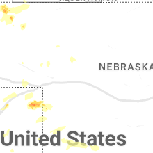
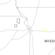
Nebraska
| Local Time | Report Details |
|---|---|
| 6:53 PM MDT | Quarter sized hail reported near Whitney, NE, 68.7 miles N of Scottsbluff, NE |
| 7:39 PM MDT | Quarter sized hail reported near Whitney, NE, 67.8 miles NNE of Scottsbluff, NE, trained spotter reported pea to quarter sized hail. time estimated from radar. |
| 8:07 PM MDT | Golf Ball sized hail reported near Whitney, NE, 66.7 miles NNE of Scottsbluff, NE, report from facebook of golf ball sized hail. |
Wyoming
| Local Time | Report Details |
|---|---|
| 7:02 PM MDT | Mesonet station kbrx 1.4 s bordeaux (wydot in platte county WY, 54.4 miles NE of Laramie, WY |
South Dakota
| Local Time | Report Details |
|---|---|
| 7:14 PM MDT | Storm damage reported in fall river county SD, 62.6 miles S of Rapid City, SD |
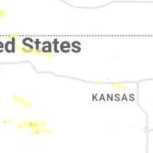
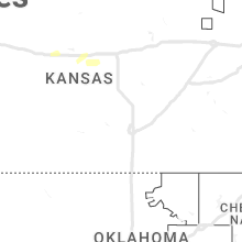
Kansas
| Local Time | Report Details |
|---|---|
| 9:37 PM MDT | Storm damage reported in wallace county KS, 55.1 miles SW of Colby, KS |
| 9:51 PM MDT | Weatherlink site homestead farm in wallace county KS, 45.1 miles SW of Colby, KS |
| 2:46 AM CDT | Report from mping: 1-inch tree limbs broken; shingles blown of in ellis county KS, 9.9 miles E of Hays, KS |
Connect with Interactive Hail Maps