

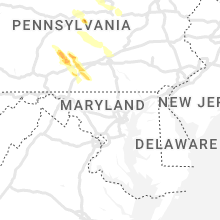
Hail Map for Friday, August 4, 2023

Number of Impacted Households on 8/4/2023
0
Impacted by 1" or Larger Hail
0
Impacted by 1.75" or Larger Hail
0
Impacted by 2.5" or Larger Hail
Square Miles of Populated Area Impacted on 8/4/2023
0
Impacted by 1" or Larger Hail
0
Impacted by 1.75" or Larger Hail
0
Impacted by 2.5" or Larger Hail


Cities Most Affected by Hail Storms of 8/4/2023
| Hail Size | Demographics of Zip Codes Affected | ||||||
|---|---|---|---|---|---|---|---|
| City | Count | Average | Largest | Pop Density | House Value | Income | Age |
| Friendsville, PA | 2 | 1.75 | 1.75 | 29 | $86k | $38.7k | 46.1 |
| Ainsworth, NE | 1 | 1.75 | 1.75 | 3 | $46k | $29.3k | 48.1 |
| Winner, SD | 1 | 1.75 | 1.75 | 4 | $55k | $29.0k | 45.4 |
Hail and Wind Damage Spotted on 8/4/2023
Filter by Report Type:Hail ReportsWind Reports
States Impacted
New York, Vermont, Mississippi, New Hampshire, Pennsylvania, Georgia, Wyoming, Nebraska, Idaho, Florida, Alabama, South Dakota, Colorado, Maryland, Missouri, Nevada, Oregon, Kansas, Texas, Oklahoma, IllinoisNew York
| Local Time | Report Details |
|---|---|
| 10:17 AM EDT | Tree down along cedarville road in the town of litchfiel in herkimer county NY, 52 miles E of Syracuse, NY |
| 10:42 AM EDT | Tree and wires down along oregon road in the town of little fall in herkimer county NY, 50 miles WNW of Schenectady, NY |
| 10:45 AM EDT | Tree uprooted. time estimated from rada in herkimer county NY, 51.5 miles WNW of Schenectady, NY |
| 10:52 AM EDT | Multiple trees and wires down throughout the city of little falls including along west main street and near the intersection of ny route 5 and south ann street. also da in herkimer county NY, 49.2 miles WNW of Schenectady, NY |
| 11:34 AM EDT | Half Dollar sized hail reported near Marcy, NY, 45.4 miles ENE of Syracuse, NY, picture on social media. |
| 12:50 PM EDT | Trees and wires down on bush rd at mowers rd. time estimated from rada in herkimer county NY, 54.1 miles E of Syracuse, NY |
| 1:06 PM EDT | Quarter sized hail reported near Utica, NY, 55.8 miles E of Syracuse, NY, image and video received showing large quantity of quarter-sized hail |
| 1:41 PM EDT | Large tree down on higby roa in oneida county NY, 46.4 miles E of Syracuse, NY |
| 2:04 PM EDT | Multiple trees down around lake moraine. pictures shared via social media. time estimated by rada in madison county NY, 35 miles ESE of Syracuse, NY |
| 2:17 PM EDT | Multiple trees reported down via social media. time estimated by rada in susquehanna county PA, 47.4 miles NNW of Scranton, PA |
| 2:28 PM EDT | At least two trees down in herkimer county NY, 72.8 miles SSE of Ogdensburg, NY |
| 2:36 PM EDT | Half Dollar sized hail reported near Schroon Lake, NY, 49.7 miles SSW of Burlington, VT |
| 2:53 PM EDT | Numerous trees down between paradox and chilso in essex county NY, 44.8 miles SSW of Burlington, VT |
| 3:04 PM EDT | Quarter sized hail reported near Edmeston, NY, 52.5 miles ESE of Syracuse, NY, picture on social media. |
| 3:10 PM EDT | Tree down on state highway 80... blocking half of the roadwa in otsego county NY, 54.6 miles ESE of Syracuse, NY |
| 3:12 PM EDT | Trees and wires down along lake shore drive in warren county NY, 52.1 miles SSW of Burlington, VT |
| 3:20 PM EDT | Several trees down across mulitple locations in essex county NY, 44.5 miles SSW of Burlington, VT |
| 3:24 PM EDT | Quarter sized hail reported near Cherry Valley, NY, 41.1 miles W of Schenectady, NY, picture from social media. |
| 3:39 PM EDT | Quarter sized hail reported near Richmondville, NY, 30.8 miles WSW of Schenectady, NY, picture of hail of at least quarter size with some slightly larger. time estimated by radar. |
| 3:48 PM EDT | Ping Pong Ball sized hail reported near Richmondville, NY, 30.8 miles WSW of Schenectady, NY |
| 3:57 PM EDT | Wires down on hust rd and over residence drivewa in sullivan county NY, 46.4 miles NE of Scranton, PA |
| 4:00 PM EDT | Quarter sized hail reported near Warnerville, NY, 29.3 miles WSW of Schenectady, NY, estimated pea to quarter sized hail |
| 4:03 PM EDT | Tree fell on car. unkown if car was occupied. time estimated based on rada in sullivan county NY, 46 miles NE of Scranton, PA |
| 4:19 PM EDT | Quarter sized hail reported near Warnerville, NY, 29.3 miles WSW of Schenectady, NY, estimated pea to quarter sized hail |
| 4:24 PM EDT | Quarter sized hail reported near Whitehall, NY, 58.4 miles NNE of Schenectady, NY, along saunders street in whitehall. time estimated by radar. |
| 5:25 PM EDT | Power outage in town of easton off gifford road due to a large tree down on a large telephone pole in washington county NY, 23.4 miles ENE of Schenectady, NY |
| 5:52 PM EDT | 5 inch diameter tree branch snapped and fell into a yar in chenango county NY, 45.1 miles SE of Syracuse, NY |
| 5:52 PM EDT | Quarter sized hail reported near Norwich, NY, 44.3 miles SE of Syracuse, NY |
| 5:53 PM EDT | Quarter sized hail reported near Mc Donough, NY, 41.7 miles SSE of Syracuse, NY |
| 6:00 PM EDT | Ping Pong Ball sized hail reported near Oxford, NY, 43.6 miles SSE of Syracuse, NY, ping pong ball-sized hail reported at the bowman lake campground. pictures via social media. |
| 6:00 PM EDT | Quarter sized hail reported near Mc Donough, NY, 41.7 miles SSE of Syracuse, NY, corrects time previous hail report from 3 ne mc donough. |
| 6:04 PM EDT | Quarter sized hail reported near Norwich, NY, 48 miles SE of Syracuse, NY |
| 6:16 PM EDT | Ping Pong Ball sized hail reported near Oxford, NY, 43.6 miles SSE of Syracuse, NY, corrects time previous hail report from 4 ene mc donough. corrects time previous hail report from 4 ene mc donough. corrects time previous hail report from 4 ene mc don |
| 6:30 PM EDT | Quarter sized hail reported near Oneonta, NY, 58 miles WSW of Schenectady, NY, observer said quarter or larger... but was unsafe to measure until awhile after it fell and melted. |
| 6:38 PM EDT | Quarter sized hail reported near Meridale, NY, 59.8 miles WSW of Schenectady, NY |
| 6:42 PM EDT | Quarter sized hail reported near East Meredith, NY, 55 miles WSW of Schenectady, NY |
| 6:50 PM EDT | Quarter sized hail reported near Bloomville, NY, 54.3 miles WSW of Schenectady, NY |
| 6:56 PM EDT | Quarter sized hail reported near Bloomville, NY, 55.4 miles SW of Schenectady, NY, picture from social media. |
| 7:04 PM EDT | Half Dollar sized hail reported near Bovina Center, NY, 55 miles SW of Schenectady, NY, picture from social media. |
| 7:16 PM EDT | Quarter sized hail reported near Unadilla, NY, 60.7 miles NNE of Scranton, PA |
| 7:30 PM EDT | Photo of a tree uprooted. time estimated by rada in broome county NY, 53.5 miles NNW of Scranton, PA |
| 8:15 PM EDT | Multiple trees and wires reports down on rock hill d in sullivan county NY, 57.4 miles ENE of Scranton, PA |
| 8:20 PM EDT | Tree and wires down across wolf lake road near the intersection of lake shore dr. e. tree is completely blocking the road and is burnin in sullivan county NY, 58.1 miles ENE of Scranton, PA |
| 8:48 PM EDT | Tree and wires down across road in ulster county NY, 69.4 miles SSW of Schenectady, NY |
| 8:50 PM EDT | Quarter sized hail reported near Circleville, NY, 60.8 miles NNW of Brooklyn, NY |
| 8:54 PM EDT | Trees and wires down on a house in ulster county NY, 71 miles SSW of Schenectady, NY |
| 8:54 PM EDT | Multiple spans of wires down in rondout valley campground in ulster county NY, 71.6 miles SSW of Schenectady, NY |
| 9:00 PM EDT | Tree and wires down in ulster county NY, 70.6 miles SSW of Schenectady, NY |
| 9:00 PM EDT | Tree struck a house and fell onto roadway in ulster county NY, 72.3 miles SSW of Schenectady, NY |
| 9:03 PM EDT | Wires down. time estimated from rada in orange county NY, 57 miles NNW of Brooklyn, NY |
| 9:08 PM EDT | Large tree down on wire in orange county NY, 60.1 miles NNW of Brooklyn, NY |
Vermont
| Local Time | Report Details |
|---|---|
| 1:28 PM EDT | Trees down in button bay state par in addison county VT, 21.7 miles SSW of Burlington, VT |
| 1:31 PM EDT | Quarter sized hail reported near Vergennes, VT, 21 miles SSW of Burlington, VT, measured by trooper in basin harbor. |
| 3:30 PM EDT | Half Dollar sized hail reported near Fair Haven, VT, 52.5 miles S of Burlington, VT |
| 4:04 PM EDT | Quarter sized hail reported near Rutland, VT, 58.7 miles SSE of Burlington, VT, dime to quarter sized hail reported by the public. |
| 4:21 PM EDT | Trees down on boardman hill road in rutland county VT, 61.7 miles S of Burlington, VT |
| 4:26 PM EDT | Quarter sized hail reported near Springfield, VT, 81 miles ENE of Schenectady, NY |
| 4:49 PM EDT | Quarter sized hail reported near North Clarendon, VT, 67.1 miles S of Burlington, VT, multiple reports of hail in clarendon. largest hail stones were up to 1 inch in diameter. |
| 5:05 PM EDT | Trees down throughout wallingford and middletown spring in rutland county VT, 67 miles NE of Schenectady, NY |
| 5:42 PM EDT | Quarter sized hail reported near Springfield, VT, 81 miles ENE of Schenectady, NY, second round of quarter sized hail. |
Mississippi
| Local Time | Report Details |
|---|---|
| 12:45 PM CDT | Small apartment complex suffered roof/awning damag in lowndes county MS, 24.5 miles E of Starkville, MS |
New Hampshire
| Local Time | Report Details |
|---|---|
| 1:56 PM EDT | Reported by amateur radio. social media photos of downed trees on river rd near the lyme-orfordville town line. time estimated by rada in grafton county NH, 67 miles SE of Burlington, VT |
| 2:02 PM EDT | Half Dollar sized hail reported near Orford, NH, 66.6 miles SE of Burlington, VT, reported by weather spotter. half-dollar size hail reported north of lyme. time estimated by radar. |
| 4:36 PM EDT | Reported by weather spotter. time estimated by rada in sullivan county NH, 86.2 miles ENE of Schenectady, NY |
| 4:42 PM EDT | Quarter sized hail reported near Charlestown, NH, 84.7 miles ENE of Schenectady, NY, reported by weather spotter. time estimated by radar. |
| 4:42 PM EDT | Ping Pong Ball sized hail reported near Charlestown, NH, 85.7 miles ENE of Schenectady, NY, reported by weather spotter. time estimated by radar. |
| 5:12 PM EDT | Delayed report: public reported tree and wires down on twistback road. time estimated by rada in sullivan county NH, 86.8 miles SSE of Burlington, VT |
| 5:22 PM EDT | Half Dollar sized hail reported near Claremont, NH, 88.2 miles SSE of Burlington, VT, reported by weather spotter. |
| 5:24 PM EDT | Quarter sized hail reported near Claremont, NH, 89 miles SSE of Burlington, VT, reported by weather spotter. |
| 5:40 PM EDT | Quarter sized hail reported near Claremont, NH, 85.7 miles SSE of Burlington, VT, time estimated by radar. |
| 5:46 PM EDT | Trees and wires down. time estimated by rada in sullivan county NH, 88.7 miles SE of Burlington, VT |
| 5:50 PM EDT | Tree down. time estimated by rada in sullivan county NH, 85.8 miles SE of Burlington, VT |
| 5:50 PM EDT | Corrects previous tstm wnd dmg report from 1 ssw grantham. tree down on road. time estimated by rada in sullivan county NH, 86.8 miles SE of Burlington, VT |
| 5:50 PM EDT | Corrects previous tstm wnd dmg report from 1 ssw grantham. tree down on road. time estimated by rada in sullivan county NH, 86.8 miles SE of Burlington, VT |
| 5:50 PM EDT | Trees and wires down. time estimated by rada in sullivan county NH, 84.9 miles SE of Burlington, VT |
| 5:52 PM EDT | Reported by amateur radio. trees down near exit 13 of interstate 89. time estimated by rada in sullivan county NH, 86.3 miles SE of Burlington, VT |
| 6:10 PM EDT | Observed several downed trees on 2nd nh turnpike between unity and lempste in sullivan county NH, 92.5 miles ENE of Schenectady, NY |
Pennsylvania
| Local Time | Report Details |
|---|---|
| 2:23 PM EDT | Trees and wires down along beech creek mountain roa in clinton county PA, 24.1 miles NNE of State College, PA |
| 2:24 PM EDT | Golf Ball sized hail reported near Friendsville, PA, 40.5 miles NNW of Scranton, PA, quarter to golf ball sized hail pictures shared by public to broadcast social media. |
| 2:30 PM EDT | Golf Ball sized hail reported near Friendsville, PA, 40.6 miles NNW of Scranton, PA |
| 2:36 PM EDT | Trees down on wires northeast of beech cree in clinton county PA, 26 miles NE of State College, PA |
| 3:12 PM EDT | Trees down on wire in lycoming county PA, 48.6 miles NE of State College, PA |
| 3:20 PM EDT | Trees down on wire in centre county PA, 25.7 miles ENE of State College, PA |
| 4:02 PM EDT | Multiple trees trees down on wire in mifflin county PA, 22.8 miles ESE of State College, PA |
| 5:10 PM EDT | Trees and wires dow in dauphin county PA, 55.9 miles ESE of State College, PA |
| 5:35 PM EDT | Quarter sized hail reported near Newville, PA, 47.7 miles SSE of State College, PA, report from mping: quarter (1.00 in.). |
| 5:55 PM EDT | Quarter sized hail reported near Shippensburg, PA, 55.9 miles SSE of State College, PA, trained spotter reports one inch hail diameter in cleversburg. |
| 6:17 PM EDT | Ping Pong Ball sized hail reported near Biglerville, PA, 60.5 miles SSE of State College, PA, picture from social media shows ping pong sized hail at pine ridge campground. time estimated by radar. |
| 6:32 PM EDT | Ping Pong Ball sized hail reported near Mapleton Depot, PA, 28.2 miles S of State College, PA, report from mping: ping pong ball (1.50 in.). |
| 7:40 PM EDT | Multiple trees and powerlines down per franklin county 911 cente in franklin county PA, 54.2 miles SSE of State College, PA |
Georgia
| Local Time | Report Details |
|---|---|
| 4:25 PM EDT | Tree down on cooper road. time estimated by rada in brooks county GA, 56 miles SW of Douglas, GA |
| 4:54 PM EDT | Trees were blown down in various areas of lowndes count in lowndes county GA, 51.9 miles SSW of Douglas, GA |
| 8:19 PM EDT | Ambient weather station reports wind gust of 68 mp in seminole county GA, 54.6 miles NW of Tallahassee, FL |
Wyoming
| Local Time | Report Details |
|---|---|
| 2:30 PM MDT | Commercial weather station measured gust of 58 mp in laramie county WY, 47.7 miles ESE of Laramie, WY |
Nebraska
| Local Time | Report Details |
|---|---|
| 3:26 PM MDT | Emergency manager estimated 60 mph winds and pea sized hail in potte in cheyenne county NE, 47.9 miles SSE of Scottsbluff, NE |
| 6:18 PM CDT | Golf Ball sized hail reported near Ainsworth, NE, 43.2 miles SE of Valentine, NE, brown/rock county ema reports quarter to golf ball sized hail. |
| 6:54 PM CDT | Quarter sized hail reported near Tryon, NE, 30.2 miles NNW of North Platte, NE, storm chaser reports quarter sized hail and smaller covering ground... quickly melting. |
| 7:00 PM CDT | Half Dollar sized hail reported near Dunning, NE, 59.5 miles SSE of Valentine, NE, hail was in progress at time of call. |
| 7:10 PM CDT | Quarter sized hail reported near Long Pine, NE, 49.7 miles W of Oneill, NE, public reports quarter sized hail via social media. |
| 6:16 PM MDT | Kiml aso in chase county NE, 61.9 miles SW of North Platte, NE |
| 6:53 PM MDT | Quarter sized hail reported near Haigler, NE, 42.2 miles E of Yuma, CO, trained spotter estimates hail up to the size of quarters... lasting around 5 minutes. |
| 6:55 PM MDT | Awos station kggf grant airpor in perkins county NE, 53.8 miles WSW of North Platte, NE |
| 8:26 PM CDT | Storm damage reported in lincoln county NE, 9.3 miles SSE of North Platte, NE |
| 9:26 PM CDT | Measured with handheld anemomete in furnas county NE, 67.3 miles SSE of North Platte, NE |
| 9:35 PM CDT | Handheld anemometer. small winds down as wel in furnas county NE, 69.4 miles SE of North Platte, NE |
Idaho
| Local Time | Report Details |
|---|---|
| 4:23 PM MDT | Quarter sized hail reported near Fairfield, ID, 55.4 miles N of Twin Falls, ID, corrects previous hail report from 8 e fairfield. largest hailstones reported were estimated quarter-sized... half-inch hail preceded. reported under core of storm. |
Florida
| Local Time | Report Details |
|---|---|
| 6:27 PM EDT | Trees reported down. time estimated by rada in jefferson county FL, 28.4 miles E of Tallahassee, FL |
| 6:37 PM EDT | Trees reported down. time estimated by rada in jefferson county FL, 20.9 miles ESE of Tallahassee, FL |
| 6:02 PM CDT | Tree down. time estimated by rada in holmes county FL, 48.9 miles NE of Miramar Beach, FL |
| 6:08 PM CDT | Tree down near 16825 highway 8 in walton county FL, 42.4 miles NNE of Miramar Beach, FL |
| 7:13 PM EDT | Multiple trees reported down throughout the county. time for the northern half of the county estimated by rada in taylor county FL, 47.3 miles ESE of Tallahassee, FL |
| 7:15 PM EDT | Tree and power line reported down. time estimated by rada in lafayette county FL, 75.4 miles ESE of Tallahassee, FL |
| 6:18 PM CDT | Tree reported down near the dogwood lakes area. time estimated by rada in holmes county FL, 48.9 miles NE of Miramar Beach, FL |
| 7:36 PM EDT | Power outages caused by downed trees and limbs. time estimated by rada in wakulla county FL, 18.5 miles SSE of Tallahassee, FL |
| 6:38 PM CDT | Em sent photos of a couple trees down near wcfr station 2. time estimated by rada in walton county FL, 22.2 miles NE of Miramar Beach, FL |
| 7:47 PM EDT | Multiple trees reported down across the county. time for the southern half of the county estimated by rada in taylor county FL, 64.4 miles SE of Tallahassee, FL |
| 7:25 PM CDT | Tree down along black creek blvd and county highway 328 in walton county FL, 18 miles ENE of Miramar Beach, FL |
| 9:40 PM EDT | Tree down near lanier road and smallpond roa in gadsden county FL, 13.1 miles NW of Tallahassee, FL |
Alabama
| Local Time | Report Details |
|---|---|
| 5:31 PM CDT | Multiple reports of trees and powerlines down in the elba are in coffee county AL, 74 miles NNE of Miramar Beach, FL |
| 5:48 PM CDT | Trees down. time estimated by rada in geneva county AL, 53.9 miles NNE of Miramar Beach, FL |
| 5:53 PM CDT | Power line reported down. time estimated by rada in dale county AL, 79.1 miles S of Auburn, AL |
| 6:10 PM CDT | Tree down. time estimated by rada in dale county AL, 83.2 miles S of Auburn, AL |
| 6:14 PM CDT | Tree reported down. time estimated by rada in geneva county AL, 57.3 miles NE of Miramar Beach, FL |
| 6:20 PM CDT | Trees reported down. time estimated by rada in henry county AL, 73.2 miles S of Auburn, AL |
| 6:35 PM CDT | Tree down in web in houston county AL, 81.6 miles NW of Tallahassee, FL |
South Dakota
| Local Time | Report Details |
|---|---|
| 5:37 PM CDT | Ping Pong Ball sized hail reported near Winner, SD, 23 miles ENE of Valentine, NE, hail size ranging from marbles to ping pong balls. |
| 5:45 PM CDT | Golf Ball sized hail reported near Winner, SD, 24.8 miles ENE of Valentine, NE |
| 7:40 PM CDT | Pw in lyman county SD, 32.2 miles SE of Pierre, SD |
| 7:47 PM CDT | Half Dollar sized hail reported near Kennebec, SD, 31.2 miles SE of Pierre, SD |
| 8:05 PM CDT | Pw in lyman county SD, 41.1 miles SSE of Pierre, SD |
Colorado
| Local Time | Report Details |
|---|---|
| 5:16 PM MDT | Mesonet station co034 i-76 julesbur in sedgwick county CO, 63.8 miles NNE of Yuma, CO |
| 5:26 PM MDT | Mesonet station co034 i-76 julesbur in sedgwick county CO, 63.8 miles NNE of Yuma, CO |
| 5:30 PM MDT | Irrigation equipment destroye in phillips county CO, 26.9 miles NNE of Yuma, CO |
Maryland
| Local Time | Report Details |
|---|---|
| 7:22 PM EDT | One power line reported down due to thunderstorm winds along sixes bridge roa in carroll county MD, 42 miles WNW of Baltimore, MD |
| 8:08 PM EDT | One tree down due to thunderstorm winds along the 14000 block of foxville roa in washington county MD, 57 miles WNW of Baltimore, MD |
| 9:54 PM EDT | One tree down due to thundertsorm winds at the intersection of gapland road and shaff roa in washington county MD, 56.2 miles W of Baltimore, MD |
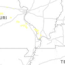
Missouri
| Local Time | Report Details |
|---|---|
| 6:37 PM CDT | Caseys gas station in norborn in carroll county MO, 50.9 miles ENE of Kansas City, MO |
| 7:04 PM CDT | Waverly apple bb in lafayette county MO, 58.1 miles E of Kansas City, MO |
| 8:06 PM CDT | 60 mph estimate from fire dept in clifton cit in cooper county MO, 40.3 miles WSW of Columbia, MO |
| 8:41 PM CDT | Estimated 60 mph winds south of bunceto in cooper county MO, 28.1 miles WSW of Columbia, MO |
| 10:17 PM CDT | Trees uprooted lying across bank road in loose cree in osage county MO, 36.9 miles SE of Columbia, MO |
| 11:13 PM CDT | *** 2 inj *** damage to several homes... power lines... and railroad equipment. people were displaced from their homes and there were 2 minor injurie in knox county MO, 28.8 miles WSW of Kahoka, MO |
Nevada
| Local Time | Report Details |
|---|---|
| 5:42 PM PDT | Antelope lake raws (alrn2)... elevation 5460 fee in elko county NV, 70.5 miles NE of Winnemucca, NV |
Oregon
| Local Time | Report Details |
|---|---|
| 5:50 PM PDT | Ping Pong Ball sized hail reported near Klamath Falls, OR, 41.6 miles ENE of Medford, OR, ping pong ball-sized hail and heavy rain reported by resort employee. |
| 5:55 PM PDT | Quarter sized hail reported near Klamath Falls, OR, 41 miles ENE of Medford, OR, quarter-sized hail reported by resort employee. |
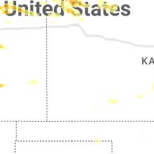
Kansas
| Local Time | Report Details |
|---|---|
| 8:22 PM CDT | Trained spotter estimates thunderstorm wind gust of 60+ mp in rawlins county KS, 40.9 miles N of Colby, KS |
| 8:35 PM CDT | Via k-state mesonet sit in rawlins county KS, 35 miles N of Colby, KS |
| 4:54 AM CDT | Storm damage reported in kingman county KS, 54.6 miles WSW of Wichita, KS |
| 4:56 AM CDT | Asos station kp28 medicine lodg in barber county KS, 72.4 miles WSW of Wichita, KS |
| 5:02 AM CDT | Tree limbs down in town... low visibility due to blowing dir in harper county KS, 53.2 miles SW of Wichita, KS |
| 5:26 AM CDT | Storm damage reported in kingman county KS, 32.3 miles WSW of Wichita, KS |
| 5:45 AM CDT | Storm damage reported in sumner county KS, 30.7 miles SW of Wichita, KS |
| 6:01 AM CDT | Storm damage reported in sumner county KS, 27.3 miles SSW of Wichita, KS |
| 6:20 AM CDT | 3 inch tree limbs and power poles down. time determined by rada in cowley county KS, 36.5 miles SSE of Wichita, KS |
| 6:21 AM CDT | Measured via personal weather statio in cowley county KS, 30.4 miles SSE of Wichita, KS |
| 6:27 AM CDT | Storm damage reported in cowley county KS, 36 miles SSE of Wichita, KS |
| 6:30 AM CDT | Strother field reported 68 mph wind gus in cowley county KS, 39.2 miles SSE of Wichita, KS |
| 6:31 AM CDT | Measured at strother fiel in cowley county KS, 39.4 miles SSE of Wichita, KS |
Texas
| Local Time | Report Details |
|---|---|
| 8:28 PM CDT | West texas mesonet. additional severe gusts recorded from 827 pm to 829 p in hall county TX, 41.2 miles W of Childress, TX |
Oklahoma
| Local Time | Report Details |
|---|---|
| 3:25 AM CDT | Mesonet station buff buffal in harper county OK, 30.4 miles NNW of Woodward, OK |
| 3:45 AM CDT | Mesonet station free freedo in woodward county OK, 25 miles NE of Woodward, OK |
| 3:50 AM CDT | Mesonet station mayr may ranc in woods county OK, 44 miles NNE of Woodward, OK |
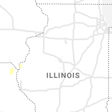
Illinois
| Local Time | Report Details |
|---|---|
| 3:46 AM CDT | A tree was blown on to a police car just east of ann in union county IL, 20.9 miles ENE of Cape Girardeau, MO |
Connect with Interactive Hail Maps