

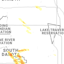
Hail Map for Tuesday, July 18, 2023

Number of Impacted Households on 7/18/2023
0
Impacted by 1" or Larger Hail
0
Impacted by 1.75" or Larger Hail
0
Impacted by 2.5" or Larger Hail
Square Miles of Populated Area Impacted on 7/18/2023
0
Impacted by 1" or Larger Hail
0
Impacted by 1.75" or Larger Hail
0
Impacted by 2.5" or Larger Hail


Cities Most Affected by Hail Storms of 7/18/2023
| Hail Size | Demographics of Zip Codes Affected | ||||||
|---|---|---|---|---|---|---|---|
| City | Count | Average | Largest | Pop Density | House Value | Income | Age |
| Pierre, SD | 9 | 2.72 | 4.50 | 27 | $96k | $43.5k | 39.7 |
| Gordon, NE | 3 | 2.50 | 3.00 | 2 | $46k | $28.0k | 45.1 |
| Fort Pierre, SD | 1 | 2.75 | 2.75 | 2 | $85k | $41.6k | 41.8 |
| Pine Ridge, SD | 1 | 1.75 | 1.75 | 0 | $21k | $20.8k | 23.5 |
Hail and Wind Damage Spotted on 7/18/2023
Filter by Report Type:Hail ReportsWind Reports
States Impacted
Missouri, Indiana, Nevada, New York, Kentucky, New Hampshire, Illinois, Tennessee, Ohio, Utah, Maine, North Carolina, South Dakota, Nebraska, West Virginia, Arkansas, Alabama, Vermont, Mississippi, Colorado, North Dakota, South CarolinaMissouri
| Local Time | Report Details |
|---|---|
| 8:06 AM CDT | Storm damage reported in pettis county MO, 59.6 miles WSW of Columbia, MO |
| 12:13 PM CDT | Asos station kcgi cape girardeau m in scott county MO, 5.4 miles SSW of Cape Girardeau, MO |
| 2:40 AM CDT | Quarter sized hail reported near Columbia, MO, 4.8 miles NW of Columbia, MO, via twitter: report of at least quarter sized hail falling for about 7 minutes. |
| 2:47 AM CDT | Quarter sized hail reported near Columbia, MO, 0.3 miles SE of Columbia, MO, spotter reported quarter sized hail in western columbia. |
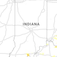
Indiana
| Local Time | Report Details |
|---|---|
| 10:18 AM EDT | Quarter sized hail reported near Leavenworth, IN, 41 miles WNW of Louisville, KY, spotter relayed photo of quarter sized hail in beechwood. time estimated from radar. |
| 5:46 PM EDT | One tree down along highway 135 south of new salisbury. time estimated by radar. report via twitte in harrison county IN, 30.5 miles NW of Louisville, KY |
Nevada
| Local Time | Report Details |
|---|---|
| 8:47 AM PDT | Mesonet station ccrn2 currant creek raws station elevation: 5750 f in nye county NV, 43.6 miles SW of Ely, NV |
New York
| Local Time | Report Details |
|---|---|
| 12:33 PM EDT | Wires down into a house along wautoma beach r in monroe county NY, 61.6 miles ENE of Buffalo, NY |
| 12:33 PM EDT | Extrapolation of report received on the shorelin in loz043 county NY, 62 miles ENE of Buffalo, NY |
| 1:45 PM EDT | Extrapolation of report received within 0.5 mile of shorelin in loz043 county NY, 57.9 miles WNW of Syracuse, NY |
| 1:45 PM EDT | Extrapolation of report received within 0.5 mile of shorelin in loz043 county NY, 57.9 miles WNW of Syracuse, NY |
| 2:17 PM EDT | Tree down on guy park avenue along with wires dow in montgomery county NY, 15.4 miles NW of Schenectady, NY |
| 2:38 PM EDT | Trees and wires down at route 226 and altay road. time estimated from rada in schuyler county NY, 60.8 miles SW of Syracuse, NY |
| 2:50 PM EDT | Trees and wires down at spencer road and route 14. time estimated from rada in schuyler county NY, 56.7 miles SW of Syracuse, NY |
| 6:15 PM EDT | Trees and powerlines down on county highway 1 in otsego county NY, 48.7 miles ESE of Syracuse, NY |
Kentucky
| Local Time | Report Details |
|---|---|
| 12:56 PM EDT | Multiple trees down or uprooted... some laying against home in meade county KY, 27.2 miles WSW of Louisville, KY |
| 12:48 PM CDT | Trees down in bandana. trees also down throughout the count in ballard county KY, 35 miles ESE of Cape Girardeau, MO |
| 12:49 PM CDT | Multiple trees down windows blown out in hous in ballard county KY, 33.5 miles SE of Cape Girardeau, MO |
| 1:00 PM CDT | Trees down over the roa in mccracken county KY, 44.4 miles ESE of Cape Girardeau, MO |
| 1:19 PM CDT | Intersection of old mayfield and bryan rd. 60+ mph winds reporte in mccracken county KY, 56.8 miles ESE of Cape Girardeau, MO |
| 1:25 PM CDT | Multiple trees and powerlines dow in marshall county KY, 51.9 miles NNE of Mc Kenzie, TN |
| 1:30 PM CDT | Trees and power lines down in tow in calloway county KY, 39.7 miles N of Mc Kenzie, TN |
| 1:35 PM CDT | Awos station km25 mayfield k in graves county KY, 44.1 miles N of Mc Kenzie, TN |
| 2:37 PM EDT | Quarter sized hail reported near Liberty, KY, 56.4 miles SE of Louisville, KY, hail ranged from peas to the size of a quarter. |
| 1:43 PM CDT | Measured wind gust on the top of kentucky da in marshall county KY, 61.9 miles NNE of Mc Kenzie, TN |
| 1:50 PM CDT | Tree fell on vehicl in lyon county KY, 68.9 miles SSW of Evansville, IN |
| 3:00 PM EDT | Delayed report. tree down in bryantsvill in garrard county KY, 37 miles W of Irvine, KY |
| 2:07 PM CDT | Storm damage to trailer and bar in caldwell county KY, 69 miles NNE of Mc Kenzie, TN |
| 2:26 PM CDT | Storm damage reported in christian county KY, 64.5 miles NW of Nashville, TN |
| 3:45 PM EDT | Trees down along white turley pike and wades mill roads. time estimated by rada in clark county KY, 26.7 miles N of Irvine, KY |
| 3:52 PM EDT | Multiple trees down along hwy 2004 around the 400 and 600 blocks. time estimated by rada in jackson county KY, 14.8 miles SSW of Irvine, KY |
| 3:55 PM EDT | Numerous trees down along highway u.s. 60 from 4670 us 60 to the bath county line. that portion of the highway will be close a few hours for tree removal. also... house in montgomery county KY, 29.4 miles N of Irvine, KY |
| 3:57 PM EDT | Social media report of power lines down along richmond road or highway 52 near the madison and estill county lin in estill county KY, 5.8 miles W of Irvine, KY |
| 4:01 PM EDT | Tree down in backyard of residence. report via social medi in estill county KY, 2.6 miles WNW of Irvine, KY |
| 4:02 PM EDT | Tree down at entrance of mountain crest apartments entranc in estill county KY, 1.4 miles N of Irvine, KY |
| 4:05 PM EDT | Social media report and photo of snapped tree limb on telephone line. time estimated based on velocity radar signatur in estill county KY, 5.8 miles E of Irvine, KY |
| 4:05 PM EDT | Trees down across bath county. time estimated from rada in bath county KY, 32.5 miles NNE of Irvine, KY |
| 4:10 PM EDT | Tree down around the 4000 block of hwy 1209. time estimate by rada in jackson county KY, 12.6 miles SSE of Irvine, KY |
| 4:23 PM EDT | Two vehicles trapped by trees on either side and power line down on lower licking road in rowan county. no injuries. time estimated by rada in rowan county KY, 37.5 miles NE of Irvine, KY |
| 4:25 PM EDT | Dispatch reported multiple trees down along both highways 587 and 11 south of beattyvill in lee county KY, 17.4 miles SE of Irvine, KY |
| 3:25 PM CDT | Reports of multiple trees down on roads and houses within russellville. time estimated by rada in logan county KY, 46.8 miles N of Nashville, TN |
| 4:36 PM EDT | Report of huge tree blocking tom rose branch rd. report via social medi in wolfe county KY, 26.9 miles E of Irvine, KY |
| 4:36 PM EDT | Large tree branch down on rose bend rd. time estimated by radar velocity signature. report and video from social medi in wolfe county KY, 27 miles E of Irvine, KY |
| 4:38 PM EDT | Social media report of two picnics flipped over and moved about 30 feet at intersection of terrill fork rd and holly road. time estimated by velocity signature on radar in wolfe county KY, 28.2 miles E of Irvine, KY |
| 3:50 PM CDT | Trees down near the intersection of bowling green road and little muddy church road. time estimated by rada in butler county KY, 66.7 miles N of Nashville, TN |
| 5:00 PM EDT | Trees down on highway 1812 on frozen hill. time estimated from rada in breathitt county KY, 35.2 miles ESE of Irvine, KY |
| 5:03 PM EDT | Nws employees estimated wind gusts to between 60-70 mph at times... which lasted about 5 minutes from 5:03 pm until about 5:08 p in breathitt county KY, 36.7 miles ESE of Irvine, KY |
| 5:08 PM EDT | Mesonet station jcak2 jackson raw in breathitt county KY, 36.7 miles ESE of Irvine, KY |
| 5:13 PM EDT | Tree down along se licking river rd and higgins branch r in magoffin county KY, 52.9 miles E of Irvine, KY |
| 5:41 PM EDT | Tree down along beechy creek. time estimated on rada in greenup county KY, 72.9 miles WNW of Charleston, WV |
| 5:50 PM EDT | Trees down. time estimated from rada in greenup county KY, 75.6 miles W of Charleston, WV |
| 5:50 PM EDT | Tree contact caused power outage in greenup county KY, 65.7 miles WNW of Charleston, WV |
| 5:52 PM EDT | Trees down. time estimated from rada in greenup county KY, 58.8 miles W of Charleston, WV |
| 5:54 PM EDT | Multiple trees down on roads in lebanon. some are impassibl in marion county KY, 38.5 miles SE of Louisville, KY |
| 6:00 PM EDT | Trees down near intersection of smith branch road and us highway 23 sout in greenup county KY, 68.6 miles WNW of Charleston, WV |
| 6:00 PM EDT | Multiple trees with power lines down. time estimated from rada in greenup county KY, 58 miles W of Charleston, WV |
| 6:05 PM EDT | Trees down near russell soccer comple in greenup county KY, 59.3 miles WNW of Charleston, WV |
| 5:21 PM CDT | Trees down near summervill in green county KY, 46.4 miles SSE of Louisville, KY |
| 6:24 PM EDT | Tree across the roadwa in greenup county KY, 60 miles W of Charleston, WV |
| 6:39 PM EDT | Multiple reports of trees down in campbellsville and across the county on roads and powerlines. a few structures were also damaged by falling tree in taylor county KY, 48.4 miles SSE of Louisville, KY |
| 6:43 PM EDT | Tree down in the pleasure ridge park are in jefferson county KY, 13.1 miles NW of Louisville, KY |
| 6:52 PM EDT | Marion county emergency manager sent pictures of a barn that was destroyed. time estimated from rada in marion county KY, 40.7 miles SE of Louisville, KY |
| 8:00 PM EDT | Tree down on fence on gum sulphur rd in the brodhead area. time estimated by radar velocity signatur in rockcastle county KY, 32.1 miles SW of Irvine, KY |
| 8:30 PM EDT | Tree and powerlines down at ky highway 3434 near noelle road. time estimated from radar velocity signatur in laurel county KY, 35.9 miles SSW of Irvine, KY |
| 8:50 PM EDT | Tyner fire dept reported to 911 dispatch a tree was down blocking the road in the daniel boone national forest. tree was removed by the fire department. time estimated in jackson county KY, 16.1 miles S of Irvine, KY |
| 1:44 AM CDT | 8 inch in diameter tree blocking highway 94 about 1.5 miles southwest of cuba... k in graves county KY, 29.3 miles N of Mc Kenzie, TN |
| 3:26 AM CDT | Spotter reports widespread wind damage in sedalia... estimates 70-80 mph gust in graves county KY, 35.3 miles N of Mc Kenzie, TN |
| 3:30 AM CDT | Tree down blocking highway 45. time estimated via rada in graves county KY, 34.8 miles NNW of Mc Kenzie, TN |
| 4:55 AM CDT | Tree down on lawrence road in southwest calloway county. road is also floode in calloway county KY, 32 miles N of Mc Kenzie, TN |
| 5:52 AM CDT | Half Dollar sized hail reported near Benton, KY, 58 miles NNE of Mc Kenzie, TN |
| 6:23 AM CDT | Tree down on highway 68... blocking one lane of traffi in trigg county KY, 51.7 miles NNE of Mc Kenzie, TN |
New Hampshire
| Local Time | Report Details |
|---|---|
| 1:30 PM EDT | Quarter sized hail reported near Troy, NH, 79.2 miles NNW of Providence, RI, multiple reports of quarter-sized hail in troy. photo posted on social media. hail fell for 4-5 mins. time estimated by radar. |
| 4:34 PM EDT | Quarter sized hail reported near Hollis, NH, 63.7 miles N of Providence, RI, hail measured at 1-inch. dented car hood. |
| 4:35 PM EDT | Half Dollar sized hail reported near Nashua, NH, 64.2 miles N of Providence, RI, measured hail up to half dollar size on broad st in w. nashua. |
| 4:35 PM EDT | Multiple trees down blocking walden pond d in hillsborough county NH, 65.3 miles N of Providence, RI |
| 4:35 PM EDT | Tree down partially blocking amherst s in hillsborough county NH, 66.1 miles N of Providence, RI |
| 4:35 PM EDT | Tree down blocking the intersection of orange and lock street in hillsborough county NH, 65.4 miles N of Providence, RI |
| 4:35 PM EDT | Large tree down on robinson r in hillsborough county NH, 68.1 miles N of Providence, RI |
| 4:35 PM EDT | Wires down blocking granite s in hillsborough county NH, 65.3 miles N of Providence, RI |
| 4:45 PM EDT | Tree and wires down on elwood r in rockingham county NH, 70.1 miles N of Providence, RI |
| 5:05 PM EDT | Quarter sized hail reported near Chester, NH, 69.5 miles SW of Portland, ME, social media photos of quarter-sized hail in chester. hail shredded leaves. |
Illinois
| Local Time | Report Details |
|---|---|
| 12:35 PM CDT | Trees down on shumaker rd just west of i-57. other trees down throughout the count in pulaski county IL, 23 miles ESE of Cape Girardeau, MO |
| 1:25 PM CDT | Large tree down on hous in pope county IL, 58.2 miles E of Cape Girardeau, MO |
| 4:39 AM CDT | Quarter sized hail reported near Ozark, IL, 40.1 miles ENE of Cape Girardeau, MO, report from mping: quarter (1.00 in.). |
Tennessee
| Local Time | Report Details |
|---|---|
| 1:36 PM CDT | Trees down over the roa in fulton county KY, 32.3 miles NW of Mc Kenzie, TN |
| 1:40 PM CDT | A carport was lifted and tossed on tn 78 across from lake county health dept in tiptonville. time is radar estimate in lake county TN, 55.7 miles WNW of Mc Kenzie, TN |
| 2:09 PM CDT | Multiple trees down across weakley county. time is radar estimate in weakley county TN, 22.9 miles N of Mc Kenzie, TN |
| 2:10 PM CDT | Trees down across highway 54. time is radar estimated. power outages in dresde in weakley county TN, 12.8 miles NNW of Mc Kenzie, TN |
| 2:11 PM CDT | Multiple trees down on snake hill rd. time is radar estimate in weakley county TN, 14.7 miles NW of Mc Kenzie, TN |
| 2:20 PM CDT | Tree on vehicle on donelson parkwa in stewart county TN, 41.1 miles NE of Mc Kenzie, TN |
| 2:21 PM CDT | Public reports a tree fell on two vehicles in the lowes parking lot. time is radar estimate in dyer county TN, 49.9 miles W of Mc Kenzie, TN |
| 2:23 PM CDT | Estimated 60 mph winds in dove in stewart county TN, 44.9 miles ENE of Mc Kenzie, TN |
| 2:24 PM CDT | Trees down on wyatt hollow roa in stewart county TN, 39.1 miles NE of Mc Kenzie, TN |
| 2:25 PM CDT | Trees down on bumpus mills roa in stewart county TN, 48 miles NE of Mc Kenzie, TN |
| 2:25 PM CDT | 20 percent of stewart county without powe in stewart county TN, 44.9 miles ENE of Mc Kenzie, TN |
| 2:27 PM CDT | Several trees down on keely mill road. time is radar estimate in gibson county TN, 23.9 miles W of Mc Kenzie, TN |
| 2:27 PM CDT | Estimated a 3 in and a 3.5 in tree limb down in dyer... tn on high stree in gibson county TN, 26.7 miles W of Mc Kenzie, TN |
| 2:28 PM CDT | One tree down on old trenton road. time is radar estimate in gibson county TN, 25.3 miles WSW of Mc Kenzie, TN |
| 2:40 PM CDT | Handful of trees down across the count in houston county TN, 47.6 miles ENE of Mc Kenzie, TN |
| 2:42 PM CDT | Trained spotter measured wind gust of 63 mp in benton county TN, 25.7 miles ENE of Mc Kenzie, TN |
| 2:50 PM CDT | Power lines down from winds causing a fir in carroll county TN, 16.8 miles S of Mc Kenzie, TN |
| 2:51 PM CDT | Power lines dow in carroll county TN, 11.9 miles SE of Mc Kenzie, TN |
| 2:55 PM CDT | Trees down across clarksville including at 229 trey ct. 5...700 without powe in montgomery county TN, 40.1 miles NW of Nashville, TN |
| 3:23 PM CDT | Multiple trees down north of camden to benton county line. a transformer was also struck by lightnin in benton county TN, 21.8 miles E of Mc Kenzie, TN |
| 3:30 PM CDT | Tspotter photo showed small tree snapped in joelto in davidson county TN, 11.7 miles NNW of Nashville, TN |
| 3:40 PM CDT | Tspotter report of tree down on house in bellevue near james lawson high schoo in davidson county TN, 12.8 miles WSW of Nashville, TN |
| 3:43 PM CDT | Tspotter report of trees and power lines down in madiso in davidson county TN, 7.4 miles NNE of Nashville, TN |
| 3:44 PM CDT | Trees down on power lines on davidson road in belle mead in davidson county TN, 6.6 miles WSW of Nashville, TN |
| 3:45 PM CDT | Large tree down in backyard of home in east nashvill in davidson county TN, 2.3 miles ENE of Nashville, TN |
| 3:47 PM CDT | Tspotter report of large trees down on new shackle roa in sumner county TN, 12.8 miles NE of Nashville, TN |
| 3:50 PM CDT | Facebook report of two trees snapped at a home in centervill in hickman county TN, 45.8 miles SW of Nashville, TN |
| 3:55 PM CDT | Facebook reports indicated a few trees down across lewis count in lewis county TN, 52.1 miles N of Florence, AL |
| 3:55 PM CDT | Tree down on saundersville rd at north greenhill r in wilson county TN, 14.8 miles ENE of Nashville, TN |
| 3:55 PM CDT | Corrects previous tstm wnd dmg report from 2 n mount juliet. trees and power pole down across sunset circle at sunset d in wilson county TN, 15.1 miles ENE of Nashville, TN |
| 3:55 PM CDT | Tree down and power outages in maryland farm in williamson county TN, 8.9 miles S of Nashville, TN |
| 4:05 PM CDT | Tspotter video showed a tree blown down in thompsons statio in williamson county TN, 26.4 miles SSW of Nashville, TN |
| 4:05 PM CDT | Facebook photo of small tree down in waynesbor in wayne county TN, 36.1 miles N of Florence, AL |
| 4:10 PM CDT | Large tree down at university dr and auburn l in maury county TN, 42.1 miles SSW of Nashville, TN |
| 4:10 PM CDT | Numerous trees down across the county with scattered power outage in maury county TN, 40.7 miles SSW of Nashville, TN |
| 4:11 PM CDT | Twitter photo received of tree down blocking a portion of holly tree gap roa in williamson county TN, 13.2 miles S of Nashville, TN |
| 4:20 PM CDT | Tree down at buffalo road and brink street and another tree down at first avenue at pulaski st in lawrenceburg. 500 customers without powe in lawrence county TN, 36.4 miles NNE of Florence, AL |
| 4:20 PM CDT | Facebook report of large tree snapped in collinwoo in wayne county TN, 26.4 miles N of Florence, AL |
| 4:23 PM CDT | Numerous trees down across lawrenceburg including one on a house at 831 north mahr av in lawrence county TN, 36.4 miles NNE of Florence, AL |
| 4:25 PM CDT | Tree down on vehicle at 225 caperton ave. driver was able to exit vehicl in lawrence county TN, 36.4 miles NNE of Florence, AL |
| 4:30 PM CDT | Facebook photo of a tree down blocking villa way in chapel hil in marshall county TN, 34.7 miles S of Nashville, TN |
| 4:37 PM CDT | Facebook reports indicate numerous trees down across giles county with a shed overturned in pulask in giles county TN, 45.8 miles NE of Florence, AL |
| 4:45 PM CDT | Tspotter report of tree down on henslee rd in whee in bedford county TN, 47.5 miles S of Nashville, TN |
| 5:54 PM CDT | Tree limbs down at sycamore view rd and raleigh lagrang in shelby county TN, 10.3 miles ENE of Memphis, TN |
| 6:00 PM CDT | Tree down in east memphis. time is radar estimate in shelby county TN, 7 miles ESE of Memphis, TN |
| 6:00 PM CDT | Large tree limbs down at poplar and yates. time is radar estimate in shelby county TN, 9.9 miles ESE of Memphis, TN |
| 6:00 PM CDT | Trees and power lines down on white station rd near meadow crest cv in memphis. time is radar estimate in shelby county TN, 9.2 miles ESE of Memphis, TN |
| 6:00 PM CDT | Tree uprooted into street in sea isle park. time is radar estimate in shelby county TN, 10.2 miles ESE of Memphis, TN |
| 6:08 PM CDT | Eleven power poles and associated power lines were downed along winchester blv in shelby county TN, 12.7 miles ESE of Memphis, TN |
| 6:10 PM CDT | Multiple trees have large limbs fallen/broken of in shelby county TN, 14.9 miles ESE of Memphis, TN |
| 6:15 PM CDT | A tree is blocking west shelby dr near reynolds road in collierville. time is radar estimate in shelby county TN, 20.2 miles ESE of Memphis, TN |
| 6:30 PM CDT | Several trees down county-wid in marion county TN, 15.9 miles WNW of Chattanooga, TN |
| 3:00 AM CDT | Quarter sized hail reported near Puryear, TN, 23.7 miles NNE of Mc Kenzie, TN |
| 4:08 AM CDT | Powerlines down on roadwa in henry county TN, 15.2 miles NE of Mc Kenzie, TN |
| 4:28 AM CDT | Report of a power pole down... lines across the roa in benton county TN, 25.7 miles ENE of Mc Kenzie, TN |
Ohio
| Local Time | Report Details |
|---|---|
| 4:21 PM EDT | Quarter sized hail reported near Oregonia, OH, 33.4 miles NE of Cincinnati, OH |
| 4:29 PM EDT | Ping Pong Ball sized hail reported near Oregonia, OH, 33.4 miles NE of Cincinnati, OH |
| 4:32 PM EDT | Several branches down on large tree. photo submitted on social media. time estimated from rada in clinton county OH, 46.1 miles ENE of Cincinnati, OH |
| 4:32 PM EDT | Ping Pong Ball sized hail reported near New Vienna, OH, 46.1 miles ENE of Cincinnati, OH, photo posted on social media. time estimated from radar. |
| 4:32 PM EDT | Quarter sized hail reported near New Vienna, OH, 46.3 miles ENE of Cincinnati, OH, photo posted on social media. time estimated from radar. |
| 5:18 PM EDT | Corrects time from previous tstm wnd dmg report from 10 ssw west portsmouth. trees reported down on tipton lane. time estimated from rada in scioto county OH, 79.5 miles NE of Irvine, KY |
| 5:20 PM EDT | Numerous trees down on us 52 in ripley area. time estimated from rada in brown county OH, 43.8 miles SE of Cincinnati, OH |
| 5:25 PM EDT | Quarter sized hail reported near Mason, OH, 19.2 miles NNE of Cincinnati, OH |
| 5:26 PM EDT | Trees reported down in nile township. time estimated from rada in scioto county OH, 80.7 miles ESE of Cincinnati, OH |
| 5:29 PM EDT | Several trees and power lines down in deerfield and hamilton townships. time estimated from rada in warren county OH, 19.7 miles NE of Cincinnati, OH |
| 5:45 PM EDT | Tree fell on top of a vehicle and into the road at the intersection of north second street and railroad street. time estimated from rada in lawrence county OH, 58.5 miles WNW of Charleston, WV |
| 5:45 PM EDT | Corrects report source from previous tstm wnd dmg report from 3 s kincaid springs. trees reported down on grassy fork road near houghland hill road. time estimated from in pike county OH, 63.8 miles SSW of Columbus, OH |
| 5:45 PM EDT | Trees down on back road. time estimated from rada in scioto county OH, 66.5 miles WNW of Charleston, WV |
| 6:00 PM EDT | Multiple pictures of trees down or snapped in and around town of syracuse sent on social media. time radar estimate in meigs county OH, 48.3 miles NNW of Charleston, WV |
| 6:02 PM EDT | Tree down on state route 93. time estimated from rada in lawrence county OH, 49.3 miles WNW of Charleston, WV |
| 6:05 PM EDT | Tree down near the intersection of oak street and south 4th street. time estimated by rada in lawrence county OH, 57.1 miles WNW of Charleston, WV |
| 6:10 PM EDT | Tree reported down on state route 243. time estimated from rada in lawrence county OH, 52.1 miles WNW of Charleston, WV |
| 6:11 PM EDT | Trees down on power lines on spring grove road. time estimated from rada in clermont county OH, 27 miles ESE of Cincinnati, OH |
| 6:13 PM EDT | Numerous trees down on us68 between mount orab and fayetteville. most damage in chasetown. time estimated from rada in brown county OH, 30.9 miles E of Cincinnati, OH |
| 6:16 PM EDT | Trees reported down near jasper on state route 104. time estimated from rada in pike county OH, 63 miles S of Columbus, OH |
| 6:21 PM EDT | Some tree limbs reported down in the buford area. time estimated from rada in highland county OH, 35.2 miles E of Cincinnati, OH |
| 6:34 PM EDT | Trees and power lines down at old us 52 between grays lane and birney lane. time estimated from rada in clermont county OH, 14.9 miles SE of Cincinnati, OH |
| 6:35 PM EDT | Tree down along martindill roa in vinton county OH, 56 miles SSE of Columbus, OH |
| 6:36 PM EDT | Tree down along lake road. time estimated from rada in vinton county OH, 57.5 miles SSE of Columbus, OH |
| 6:36 PM EDT | Tree down near intersection of 324 and state route 16 in vinton county OH, 63 miles SSE of Columbus, OH |
| 6:54 PM EDT | Trees and power lines down throughout west union. time estimated from rada in adams county OH, 55.6 miles ESE of Cincinnati, OH |
| 9:13 PM EDT | Trees reported down on tipton lane. time estimated from rada in scioto county OH, 79.5 miles NE of Irvine, KY |
Utah
| Local Time | Report Details |
|---|---|
| 2:29 PM MDT | Awos station kenv wendover airpor in tooele county UT, 92 miles E of Elko, NV |
| 2:42 PM MDT | Asos station kcny 16 nw moa in grand county UT, 67.6 miles WSW of Grand Junction, CO |
| 2:50 PM MDT | Mesonet station utrch i-70 at richfiel in sevier county UT, 9.6 miles N of Monroe, UT |
| 3:40 PM MDT | Mesonet station pc358 hansel valle in box elder county UT, 85.6 miles NNW of Salt Lake City, UT |
| 3:50 PM MDT | Mesonet station utckh chaulk hil in box elder county UT, 87.8 miles NNW of Salt Lake City, UT |
| 4:00 PM MDT | Mesonet station pc349 nephi wes in juab county UT, 60.3 miles W of Price, UT |
| 5:20 PM MDT | Mesonet station utdcd us-189 at deer creek da in wasatch county UT, 30.6 miles SE of Salt Lake City, UT |
Maine
| Local Time | Report Details |
|---|---|
| 5:00 PM EDT | Tree and wires down on spring s in oxford county ME, 60.8 miles N of Portland, ME |
| 5:13 PM EDT | 1 foot of water flowing over old county r in oxford county ME, 49.6 miles NNW of Portland, ME |
North Carolina
| Local Time | Report Details |
|---|---|
| 5:00 PM EDT | County 911 center reports multiple trees blown down from enka south toward avery cree in buncombe county NC, 46.8 miles N of Greenville, SC |
| 5:26 PM EDT | Several trees down on power lines/utility equipment in the horse shoe are in henderson county NC, 35.2 miles N of Greenville, SC |
| 5:35 PM EDT | County officials report multiple trees blown down west of hendersonville from mills river south toward laurel par in henderson county NC, 34 miles N of Greenville, SC |
| 11:30 PM EDT | Several trees and power lines down in andrews... n in cherokee county NC, 52.1 miles S of Knoxville, TN |
| 3:40 AM UTC | Reports of a few trees down across the county from near franklin to highland in macon county NC, 48.2 miles WNW of Greenville, SC |
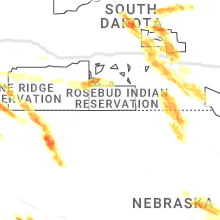
South Dakota
| Local Time | Report Details |
|---|---|
| 3:05 PM MDT | Quarter sized hail reported near Pine Ridge, SD, 79.4 miles SSE of Rapid City, SD |
| 3:05 PM MDT | Quarter sized hail reported near Pine Ridge, SD, 79.6 miles SSE of Rapid City, SD |
| 3:06 PM MDT | Golf Ball sized hail reported near Pine Ridge, SD, 75.6 miles SSE of Rapid City, SD |
| 6:37 PM CDT | Quarter sized hail reported near Pierre, SD, 0.1 miles N of Pierre, SD |
| 6:40 PM CDT | Hen Egg sized hail reported near Pierre, SD, 2.6 miles ENE of Pierre, SD |
| 6:40 PM CDT | Hen Egg sized hail reported near Pierre, SD, 1.7 miles ENE of Pierre, SD, reported via facebook. |
| 6:43 PM CDT | Tea Cup sized hail reported near Pierre, SD, 0.1 miles N of Pierre, SD, photo submitted via twitter. |
| 6:43 PM CDT | Golf Ball sized hail reported near Pierre, SD, 0.1 miles N of Pierre, SD, multiple public reports via facebook. |
| 6:45 PM CDT | Baseball sized hail reported near Pierre, SD, 0.1 miles N of Pierre, SD, reported via facebook. |
| 5:45 PM MDT | Baseball sized hail reported near Fort Pierre, SD, 1.5 miles W of Pierre, SD, photo submitted via facebook. |
| 6:47 PM CDT | Softball sized hail reported near Pierre, SD, 0.6 miles S of Pierre, SD, photo submitted via facebook. |
| 6:56 PM CDT | Tennis Ball sized hail reported near Pierre, SD, 1.2 miles ESE of Pierre, SD |
| 7:00 PM CDT | Tea Cup sized hail reported near Pierre, SD, 0.1 miles N of Pierre, SD, photo submitted via twitter. |
| 7:18 PM CDT | Tea Cup sized hail reported near Pierre, SD, 0.5 miles E of Pierre, SD, photo submitted via facebook. |
| 7:48 PM CDT | Storm damage reported in lyman county SD, 43.1 miles ESE of Pierre, SD |
| 8:05 PM CDT | Semi tipped over along i-9 in lyman county SD, 50.9 miles SE of Pierre, SD |
| 8:05 PM CDT | Semi tipped over along i-9 in lyman county SD, 60.6 miles SE of Pierre, SD |
| 8:15 PM CDT | Mesonet station ocms2 oacoma 2w (sd mesonet in lyman county SD, 60.7 miles SE of Pierre, SD |
| 8:22 PM CDT | Corrects previous tstm wnd gst report from 3 s chamberlai in brule county SD, 65.9 miles SE of Pierre, SD |
| 8:22 PM CDT | Corrects previous tstm wnd gst report from 3 s chamberlai in brule county SD, 65.9 miles SE of Pierre, SD |
| 8:28 PM CDT | Mesonet station 54 reliance (sddot in lyman county SD, 53.2 miles SE of Pierre, SD |
| 10:15 PM CDT | Sdsu mesonet site ggms2 7 ssw gregor in gregory county SD, 56.8 miles ENE of Valentine, NE |
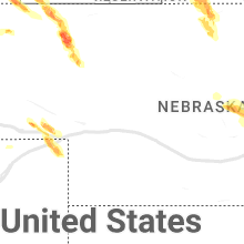
Nebraska
| Local Time | Report Details |
|---|---|
| 3:24 PM MDT | Half Dollar sized hail reported near Rushville, NE, 87.1 miles SSE of Rapid City, SD |
| 3:40 PM MDT | Tennis Ball sized hail reported near Gordon, NE, 91.5 miles W of Valentine, NE |
| 3:50 PM MDT | Quarter sized hail reported near Gordon, NE, 91.6 miles NE of Scottsbluff, NE |
| 3:52 PM MDT | Hen Egg sized hail reported near Gordon, NE, 91.5 miles NE of Scottsbluff, NE |
| 4:00 PM MDT | Quarter sized hail reported near Gordon, NE, 84.2 miles W of Valentine, NE |
| 4:10 PM MDT | Tea Cup sized hail reported near Gordon, NE, 84.9 miles W of Valentine, NE |
| 5:04 PM MDT | Quarter sized hail reported near Lodgepole, NE, 69.5 miles SE of Scottsbluff, NE, spotter reported that corn was stripped. |
| 5:05 PM MDT | Quarter sized hail reported near Ashby, NE, 81.5 miles WSW of Valentine, NE |
| 5:05 PM MDT | Storm damage reported in cherry county NE, 81.5 miles WSW of Valentine, NE |
| 5:34 PM MDT | Storm damage reported in deuel county NE, 67.6 miles N of Yuma, CO |
| 9:05 PM MDT | Quarter sized hail reported near Chappell, NE, 72.4 miles NNE of Yuma, CO |
West Virginia
| Local Time | Report Details |
|---|---|
| 5:32 PM EDT | Quarter sized hail reported near Ashton, WV, 33.8 miles WNW of Charleston, WV, also spotted a funnel cloud forming and spinning... falling apart and forming again several times before it went over the hill while on the phone at 540 pm. |
| 5:36 PM EDT | Quarter sized hail reported near Mason, WV, 50.8 miles NNW of Charleston, WV, hail between 1 inch to half dollar size. time estimated from radar. verified 1 inch hail from picture on social media. |
| 5:45 PM EDT | Two trees down blocking state route 34 sout in putnam county WV, 19.6 miles W of Charleston, WV |
| 5:50 PM EDT | Large tree down. power is also ou in kanawha county WV, 10 miles WNW of Charleston, WV |
| 5:53 PM EDT | Quarter sized hail reported near New Haven, WV, 47.6 miles NNW of Charleston, WV, also heard that a funnel cloud had been spotted. |
| 5:54 PM EDT | Tree down on a house on guyan river road in ranger. time estimated from rada in lincoln county WV, 33.6 miles WSW of Charleston, WV |
| 5:55 PM EDT | Tree reported down. time estimated by rada in putnam county WV, 14.8 miles WNW of Charleston, WV |
| 5:55 PM EDT | Tree reported down. time estimated by rada in putnam county WV, 12.9 miles WNW of Charleston, WV |
| 6:00 PM EDT | Quarter sized hail reported near New Haven, WV, 47.6 miles NNW of Charleston, WV |
| 6:03 PM EDT | 15 to 20 trees down between hartford and the jackson county line. power poles also down in this area in 2 separate places. time estimated from rada in mason county WV, 48.7 miles NNW of Charleston, WV |
| 6:12 PM EDT | Multiple trees and power lines down in the area of range in lincoln county WV, 33.9 miles WSW of Charleston, WV |
| 6:42 PM EDT | Tree down along ambler roa in roane county WV, 23.8 miles NNE of Charleston, WV |
| 6:44 PM EDT | Tree and power lines down along harmony road. time estimated from rada in roane county WV, 23.7 miles NNE of Charleston, WV |
| 7:00 PM EDT | Power lines and tree down along poca roa in roane county WV, 29.6 miles NE of Charleston, WV |
| 7:04 PM EDT | Tree down along slate roa in roane county WV, 35.5 miles NNE of Charleston, WV |
| 7:05 PM EDT | Tree and power lines down. time estimated from rada in gilmer county WV, 53.1 miles W of Elkins, WV |
| 7:05 PM EDT | Tree and power lines down. time estimated from rada in gilmer county WV, 53.1 miles W of Elkins, WV |
| 7:06 PM EDT | Power out in the area of glennvill in gilmer county WV, 53.1 miles W of Elkins, WV |
| 7:10 PM EDT | Tree reported down blocking both lanes of u.s. highway 33 wes in gilmer county WV, 54.7 miles W of Elkins, WV |
| 7:11 PM EDT | Multiple trees reported down and carports flippe in gilmer county WV, 53.6 miles W of Elkins, WV |
| 7:13 PM EDT | Multiple reports reports of trees and lines down in the sand fork area. time estimated from rada in gilmer county WV, 48.8 miles W of Elkins, WV |
| 7:14 PM EDT | Power pole and transformer dow in gilmer county WV, 53.1 miles W of Elkins, WV |
| 7:19 PM EDT | Multiple trees down. route 5 is shut down just past sand fork. time estimated from rada in gilmer county WV, 48.3 miles W of Elkins, WV |
| 7:19 PM EDT | Trees and power lines down. 2 broken power poles. time estimated from rada in gilmer county WV, 48.8 miles W of Elkins, WV |
| 7:19 PM EDT | Multiple trees down along sand fork road. time estimated from rada in gilmer county WV, 47.7 miles W of Elkins, WV |
| 7:31 PM EDT | Trees down near the intersection of route 5. time estimated from rada in gilmer county WV, 46.1 miles W of Elkins, WV |
| 11:55 PM EDT | A tree is down on coal heritage rd... blocking both lane in mcdowell county WV, 63.5 miles S of Charleston, WV |
Arkansas
| Local Time | Report Details |
|---|---|
| 4:40 PM CDT | Trees blown down onto power lines east of alici in lawrence county AR, 76.9 miles NW of Memphis, TN |
| 4:42 PM CDT | Relayed by oem from sheriff office: powerline down on hwy 61 south of blytheville near hwy 312. time is radar estimate in mississippi county AR, 53 miles N of Memphis, TN |
| 4:50 PM CDT | Large tree down off gee street in jonesbor in craighead county AR, 61.2 miles NW of Memphis, TN |
| 5:10 PM CDT | One tree down on freer rd. time is radar estimate in poinsett county AR, 44.8 miles NNW of Memphis, TN |
| 5:12 PM CDT | Tree down... power outages... and a flag pole down. time is radar estimate in poinsett county AR, 44.9 miles NW of Memphis, TN |
Alabama
| Local Time | Report Details |
|---|---|
| 5:05 PM CDT | Storm damage reported in limestone county AL, 43 miles E of Florence, AL |
| 5:05 PM CDT | Trees reported downed along cannon rd by em in limestone county AL, 35.9 miles E of Florence, AL |
| 5:16 PM CDT | Nw of nick davis and jeff rd intersectio in madison county AL, 54.3 miles E of Florence, AL |
| 5:18 PM CDT | Power lines down blocking wall triana between hwy 72 and capshaw r in madison county AL, 52.7 miles E of Florence, AL |
| 5:22 PM CDT | Tree downed near hwys 101 and 194 north of town cree in colbert county AL, 14.4 miles ESE of Florence, AL |
| 5:25 PM CDT | Tree downed near intersection of sheldon and malor cir (northern intersection in madison county AL, 54.8 miles E of Florence, AL |
| 5:34 PM CDT | Wind gusts of 60-70 mph near interchange of i-565 and mooresville r in limestone county AL, 46.8 miles ESE of Florence, AL |
| 5:34 PM CDT | Tree downed near intersection of patton rd sw and drake ave sw - reported by off duty nws meteorologis in madison county AL, 59.9 miles E of Florence, AL |
| 5:42 PM CDT | Estimated wind gusts of 60-70 mp in limestone county AL, 43.3 miles ENE of Florence, AL |
| 5:54 PM CDT | Several trees down in the baileyton are in cullman county AL, 52.3 miles NNE of Birmingham, AL |
| 6:30 PM CDT | Large tree blocking roadway in oneonta. winds around 40-50 mp in blount county AL, 35.5 miles NNE of Birmingham, AL |
| 6:30 PM CDT | Trees and power lines down on lehigh rd.... trafford... and timmerman circle in blountsville. winds estimated between 40-50 mp in blount county AL, 41.3 miles NNE of Birmingham, AL |
| 6:45 PM CDT | Tree fallen on county road 82 north of weiss lake. winds estimated between 40-50 mp in cherokee county AL, 56 miles SSW of Chattanooga, TN |
| 6:45 PM CDT | Several reports of trees down. one over a power line and several over roads in steele... al. a person also hit a tree... no injuries. winds estimated between 40-50 mp in st. clair county AL, 45.6 miles NE of Birmingham, AL |
| 7:10 PM CDT | Tree down near the intersection of morgan bridge rd. and al hwy 144. winds estimated between 40-50 mp in st. clair county AL, 34 miles ENE of Birmingham, AL |
| 8:25 PM CDT | Trees were blown down in and around hamilton. winds were estimated at 50-55 mp in marion county AL, 48.3 miles SSW of Florence, AL |
| 8:40 PM CDT | Trees were blown down in sulligen in lamar county AL, 49.4 miles NE of Starkville, MS |
| 8:42 PM CDT | Trees were blown down in and around guin. winds were estimated at 50-55 mp in marion county AL, 58.8 miles SSW of Florence, AL |
| 8:48 PM CDT | Trees were blown down in verno in lamar county AL, 45.3 miles ENE of Starkville, MS |
| 8:55 PM CDT | Tree on home on 3rd ave nw in fayette. trees and power lines reported down across fayette count in fayette county AL, 58.8 miles ENE of Starkville, MS |
| 8:57 PM CDT | Trees and power lines were blown down near carbon hil in walker county AL, 48.6 miles WNW of Birmingham, AL |
| 9:32 PM CDT | Trees down in several locations across pickens county including near gord in pickens county AL, 52.7 miles ESE of Starkville, MS |
| 9:46 PM CDT | Tree reported down on power line on highway 216 in the lake view are in tuscaloosa county AL, 24.8 miles SW of Birmingham, AL |
| 9:52 PM CDT | A few trees down... some on power lines... in the tuscaloosa are in tuscaloosa county AL, 49.8 miles SW of Birmingham, AL |
| 10:17 PM CDT | Trees down near centrevill in bibb county AL, 43.7 miles SSW of Birmingham, AL |
Vermont
| Local Time | Report Details |
|---|---|
| 6:10 PM EDT | 2 trees downed in tunbridge by thunderstorm wind gusts; 1 knocking out electricity to a residence and 1 blocking a roa in orange county VT, 56.3 miles SE of Burlington, VT |
Mississippi
| Local Time | Report Details |
|---|---|
| 6:15 PM CDT | Kolv reports 54kts at 2315 in desoto county MS, 18.8 miles SE of Memphis, TN |
| 7:00 PM CDT | Power lines down blocking road on hwy 311. time is radar estimate in marshall county MS, 37.1 miles ESE of Memphis, TN |
| 7:06 PM CDT | Large tree uprooted in blue mountain. time is radar estimate in tippah county MS, 66.6 miles ESE of Memphis, TN |
| 7:31 PM CDT | A carport was blown over on cr 6071 in sw prentiss count in prentiss county MS, 60.3 miles WSW of Florence, AL |
| 7:39 PM CDT | Trees and power lines down on cr 5491 near marietta... m in prentiss county MS, 51.4 miles WSW of Florence, AL |
| 7:41 PM CDT | Trees dpwm netweem natchez trace and marietta along ms 371 blocking the road. time is radar estimate in prentiss county MS, 50.9 miles WSW of Florence, AL |
Colorado
| Local Time | Report Details |
|---|---|
| 6:10 PM MDT | Quarter sized hail reported near Ovid, CO, 59.3 miles NNE of Yuma, CO |
North Dakota
| Local Time | Report Details |
|---|---|
| 8:10 PM CDT | Quarter sized hail reported near Harvey, ND, 48.1 miles SW of Devils Lake, ND |
| 10:40 PM CDT | Quarter sized hail reported near Ashley, ND, 57.6 miles NW of Aberdeen, SD, hail just began. |
South Carolina
| Local Time | Report Details |
|---|---|
| 1:27 AM EDT | Trees down on power lines/utility equipment in the belvue school rd are in greenville county SC, 16 miles NE of Greenville, SC |
| 1:36 AM EDT | Trees down on power lines/utility equipment in the lake robinson are in greenville county SC, 20.3 miles ENE of Greenville, SC |
| 1:39 AM EDT | Trees down on power lines/utility equipment in the highland are in greenville county SC, 25.2 miles NE of Greenville, SC |
| 1:58 AM EDT | Trees down on power lines/utility equipment in the inman are in spartanburg county SC, 32.7 miles ENE of Greenville, SC |
Connect with Interactive Hail Maps