

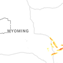
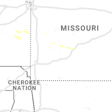
Hail Map for Wednesday, July 19, 2023

Number of Impacted Households on 7/19/2023
0
Impacted by 1" or Larger Hail
0
Impacted by 1.75" or Larger Hail
0
Impacted by 2.5" or Larger Hail
Square Miles of Populated Area Impacted on 7/19/2023
0
Impacted by 1" or Larger Hail
0
Impacted by 1.75" or Larger Hail
0
Impacted by 2.5" or Larger Hail


Cities Most Affected by Hail Storms of 7/19/2023
| Hail Size | Demographics of Zip Codes Affected | ||||||
|---|---|---|---|---|---|---|---|
| City | Count | Average | Largest | Pop Density | House Value | Income | Age |
| Torrington, WY | 5 | 2.15 | 2.75 | 13 | $79k | $33.0k | 43.0 |
| Morrill, NE | 4 | 2.00 | 2.50 | 8 | $55k | $31.2k | 42.7 |
| Rice Lake, WI | 4 | 2.00 | 2.50 | 73 | $78k | $37.4k | 42.6 |
| Deer River, MN | 2 | 2.13 | 2.50 | 11 | $69k | $30.6k | 43.0 |
| Hendricks, MN | 2 | 1.88 | 2.00 | 14 | $41k | $29.3k | 50.7 |
| Kelliher, MN | 2 | 1.75 | 1.75 | 3 | $32k | $21.4k | 48.3 |
| Marcell, MN | 1 | 2.75 | 2.75 | 7 | $111k | $34.0k | 57.0 |
| Canby, MN | 1 | 2.00 | 2.00 | 11 | $43k | $30.7k | 45.7 |
| Shell Lake, WI | 1 | 2.00 | 2.00 | 29 | $84k | $33.7k | 45.2 |
| Waverly, MN | 1 | 1.75 | 1.75 | 63 | $125k | $53.1k | 34.9 |
| Chugwater, WY | 1 | 1.75 | 1.75 | 0 | $73k | $37.9k | 47.8 |
| Webster, WI | 1 | 1.75 | 1.75 | 27 | $87k | $35.0k | 49.3 |
| Albany, MN | 1 | 1.75 | 1.75 | 41 | $93k | $37.3k | 35.0 |
| Siren, WI | 1 | 1.75 | 1.75 | 45 | $80k | $32.0k | 46.5 |
Hail and Wind Damage Spotted on 7/19/2023
Filter by Report Type:Hail ReportsWind Reports
States Impacted
Illinois, Tennessee, North Carolina, South Dakota, Minnesota, Colorado, South Carolina, Wyoming, Florida, New Mexico, Wisconsin, Kansas, Nebraska, Utah, PennsylvaniaIllinois
| Local Time | Report Details |
|---|---|
| 7:01 AM CDT | Tree over roa in union county IL, 16.3 miles ENE of Cape Girardeau, MO |
Tennessee
| Local Time | Report Details |
|---|---|
| 10:45 AM CDT | 30 to 40 trees reportedly blown down across southern lawrence county from westpoint road to the giles county lin in lawrence county TN, 24.2 miles NNE of Florence, AL |
North Carolina
| Local Time | Report Details |
|---|---|
| 2:45 PM EDT | Tree and powerline down near the intersection of alex benton road and friday road. time estimated by rada in sampson county NC, 40.9 miles SSE of Raleigh, NC |
| 5:58 PM EDT | Trees down near the intersection of hayfield road and s river school road. time estimated by rada in cumberland county NC, 48 miles S of Raleigh, NC |
| 6:19 PM EDT | Trees down near the intersection of rock hill road and dunn road. time estimated by rada in cumberland county NC, 49.4 miles S of Raleigh, NC |
| 7:04 PM EDT | Tree down on powerline and blocking huffmantown rd near cox r in onslow county NC, 53 miles NNE of Wilmington, NC |
| 9:35 PM EDT | Surf city weatherflow site reported a gust of 60 mp in pender county NC, 26 miles ENE of Wilmington, NC |
South Dakota
| Local Time | Report Details |
|---|---|
| 2:50 PM CDT | Quarter sized hail reported near Bruce, SD, 62.3 miles N of Sioux Falls, SD, mping report of quarter size hail. |
| 3:15 PM CDT | Half Dollar sized hail reported near Astoria, SD, 49.1 miles SW of Montevideo, MN, social media picture. |
Minnesota
| Local Time | Report Details |
|---|---|
| 2:55 PM CDT | Quarter sized hail reported near Cohasset, MN, 61.9 miles ESE of Bemidji, MN, hailstone was measured next to a quarter. spotter notes that the hail was slightly larger than the quarter. |
| 3:02 PM CDT | Half Dollar sized hail reported near Baudette, MN, 52.2 miles ESE of Roseau, MN, half dollar sized hail reported by the public 5 sw baudette. |
| 3:08 PM CDT | Quarter sized hail reported near Emily, MN, 72.3 miles SE of Bemidji, MN, quarter size hail report from mping. |
| 3:13 PM CDT | Quarter sized hail reported near Kelliher, MN, 35.6 miles NNE of Bemidji, MN |
| 3:15 PM CDT | Golf Ball sized hail reported near Kelliher, MN, 35.6 miles NNE of Bemidji, MN, size estimated from pictures. time estimated from radar. |
| 3:23 PM CDT | Golf Ball sized hail reported near Hendricks, MN, 45.1 miles SW of Montevideo, MN, hail varied from pea size to golf ball size. |
| 3:24 PM CDT | Hen Egg sized hail reported near Hendricks, MN, 41.6 miles SW of Montevideo, MN, social media picture. |
| 3:26 PM CDT | Quarter sized hail reported near Kelliher, MN, 36.1 miles NNE of Bemidji, MN |
| 3:28 PM CDT | Hen Egg sized hail reported near Canby, MN, 40.6 miles SW of Montevideo, MN, social media picture. |
| 3:37 PM CDT | Golf Ball sized hail reported near Kelliher, MN, 38 miles NNE of Bemidji, MN, lots of damage to vehicle due to large hail. |
| 3:50 PM CDT | Quarter sized hail reported near Deer River, MN, 45 miles E of Bemidji, MN, spotter reports dime to quarter sized hail. |
| 4:03 PM CDT | Quarter sized hail reported near Marshall, MN, 27 miles SSW of Montevideo, MN, social media report. |
| 4:05 PM CDT | Golf Ball sized hail reported near Deer River, MN, 50.8 miles E of Bemidji, MN, report via social media with photo. time estimated from radar. |
| 4:10 PM CDT | Tennis Ball sized hail reported near Deer River, MN, 50 miles E of Bemidji, MN, report from social media of numerous 2 to 2.5 inch diameter hailstones with measuring tape photo. |
| 4:15 PM CDT | Quarter sized hail reported near Cottonwood, MN, 23.7 miles S of Montevideo, MN, report from mping: quarter (1.00 in.). |
| 4:15 PM CDT | Baseball sized hail reported near Marcell, MN, 56.2 miles E of Bemidji, MN, report via social media with video. observer reports they have broken windows and a dented car. time estimated from radar. |
| 4:25 PM CDT | Numerous 3 to 4 inch diameter branches down... generally 5 to 10 feet lon in pope county MN, 45 miles NNE of Montevideo, MN |
| 4:25 PM CDT | Quarter sized hail reported near Starbuck, MN, 45 miles NNE of Montevideo, MN, hail melted quickly but some piles were still around as of 445 pm. |
| 4:35 PM CDT | Quarter sized hail reported near Bovey, MN, 67.9 miles E of Bemidji, MN, photo was taken of quarter sized hail and was reported to be slightly larger than a quarter. |
| 4:47 PM CDT | Golf Ball sized hail reported near Albany, MN, 70 miles NE of Montevideo, MN |
| 4:47 PM CDT | Quarter sized hail reported near Sturgeon Lake, MN, 44.8 miles SW of Duluth, MN, photo via social media with measuring tape. time estimated from radar. |
| 4:48 PM CDT | Ping Pong Ball sized hail reported near Albany, MN, 71.2 miles NE of Montevideo, MN |
| 4:51 PM CDT | Quarter sized hail reported near Sturgeon Lake, MN, 43.6 miles SW of Duluth, MN |
| 4:52 PM CDT | Quarter sized hail reported near Sturgeon Lake, MN, 42.6 miles SW of Duluth, MN |
| 4:53 PM CDT | Ping Pong Ball sized hail reported near Willow River, MN, 47.8 miles SW of Duluth, MN, report via broadcast meteorologist viewer with photo. time estimated from radar. |
| 5:05 PM CDT | Ping Pong Ball sized hail reported near Bruno, MN, 44.4 miles SW of Duluth, MN |
| 5:15 PM CDT | Relayed via stearns county e in stearns county MN, 67 miles ENE of Montevideo, MN |
| 5:20 PM CDT | Half Dollar sized hail reported near Sturgeon Lake, MN, 44 miles SW of Duluth, MN, report from social media with photo. |
| 5:26 PM CDT | Six to eight inch tree branches down with time estimated based on rada in stearns county MN, 65.9 miles WNW of Minneapolis, MN |
| 5:33 PM CDT | Quarter sized hail reported near Grand Rapids, MN, 65.3 miles E of Bemidji, MN |
| 6:00 PM CDT | Golf Ball sized hail reported near Waverly, MN, 35.1 miles W of Minneapolis, MN |
| 6:09 PM CDT | Quarter sized hail reported near Bovey, MN, 64.8 miles NW of Duluth, MN, quarter size hail. location approximate. time estimated by radar. |
| 6:09 PM CDT | Report of a tightly rotating mesocyclone and possible wind or tornado damage on highway 169 approximately 2 miles east of calumet. location approximate. time estimated in itasca county MN, 65.2 miles NW of Duluth, MN |
| 6:10 PM CDT | Several 8 to 10 inch diameter aspen trees down pointing from northwest and southeast. time estimated from rada in itasca county MN, 65.6 miles NW of Duluth, MN |
| 6:12 PM CDT | Quarter sized hail reported near Buffalo, MN, 29.8 miles WNW of Minneapolis, MN, report from mping: quarter (1.00 in.). |
| 6:15 PM CDT | Small 5 inch diameter tree down blown down facing west. time estimated by rada in itasca county MN, 63.6 miles NW of Duluth, MN |
| 6:33 PM CDT | Also measured 62 mph at 630 p in hennepin county MN, 18.1 miles NNW of Minneapolis, MN |
| 6:45 PM CDT | Asos station kmic crystal a in hennepin county MN, 7.5 miles NNW of Minneapolis, MN |
| 7:00 PM CDT | Quarter sized hail reported near Duluth, MN, 6.3 miles NW of Duluth, MN, numerous hailstones with the largest stones up to quarter size. |
| 7:00 PM CDT | Quarter sized hail reported near Duluth, MN, 7 miles WNW of Duluth, MN, spotter reports nickel to quarter sized hail. |
| 7:52 PM CDT | Quarter sized hail reported near Inver Grove Heights, MN, 13.8 miles SE of Minneapolis, MN |
Colorado
| Local Time | Report Details |
|---|---|
| 2:25 PM MDT | Quarter sized hail reported near Colorado Springs, CO, 50 miles N of Pueblo, CO, report received via media. |
| 3:01 PM MDT | Quarter sized hail reported near Calhan, CO, 53.4 miles NNE of Pueblo, CO, largest hail stone was 1.1 inches. time is estimated. |
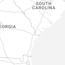
South Carolina
| Local Time | Report Details |
|---|---|
| 4:35 PM EDT | Allendale awos gusted to 58 mp in allendale county SC, 53 miles SE of Augusta, GA |
| 4:49 PM EDT | Tree down blocking road near the intersection of fitts and bluff roa in allendale county SC, 51.9 miles SE of Augusta, GA |
| 4:57 PM EDT | Tree down blocking road near the intersection of barton road and lakey driv in allendale county SC, 55.3 miles SE of Augusta, GA |
| 5:05 PM EDT | 3 trees down on us 321 between fairfax and lura in hampton county SC, 57.8 miles N of Savannah, GA |
| 5:05 PM EDT | One tree reported down near broxton bridge plantatio in colleton county SC, 61 miles WSW of Charleston, SC |
| 6:06 PM EDT | Approximately 40 pieces of vinyl siding stripped off the side of a chimne in dorchester county SC, 17.5 miles SSW of Charleston, SC |
Wyoming
| Local Time | Report Details |
|---|---|
| 3:00 PM MDT | Golf Ball sized hail reported near Chugwater, WY, 49.3 miles NE of Laramie, WY, received report of windows shattered on homes and vehicles south of chugwater. time estimated based on radar. |
| 3:32 PM MDT | Quarter sized hail reported near Chugwater, WY, 47.4 miles W of Scottsbluff, NE, facebook photo shows hail stone and quarter. |
| 4:00 PM MDT | Ping Pong Ball sized hail reported near Yoder, WY, 37.8 miles W of Scottsbluff, NE, initially ping pong ball size hail then mostly dime size. |
| 4:10 PM MDT | Quarter sized hail reported near Torrington, WY, 36.2 miles WNW of Scottsbluff, NE, received report via facebook. |
| 4:14 PM MDT | Quarter sized hail reported near Torrington, WY, 33.5 miles WNW of Scottsbluff, NE |
| 4:16 PM MDT | Tennis Ball sized hail reported near Torrington, WY, 33.5 miles WNW of Scottsbluff, NE |
| 4:25 PM MDT | Golf Ball sized hail reported near Torrington, WY, 28.8 miles WNW of Scottsbluff, NE, golf ball sized hail reported at resturant 3s of torrington. car windows broken. |
| 4:26 PM MDT | Golf Ball sized hail reported near Torrington, WY, 30.5 miles WNW of Scottsbluff, NE, report from mping: golf ball (1.75 in.). |
| 4:27 PM MDT | Half Dollar sized hail reported near Glendo, WY, 70.9 miles ESE of Casper, WY |
| 4:27 PM MDT | Hen Egg sized hail reported near Torrington, WY, 30.5 miles WNW of Scottsbluff, NE, report from mping of hen egg size hail. |
| 4:30 PM MDT | Baseball sized hail reported near Torrington, WY, 28.1 miles WNW of Scottsbluff, NE, lasted about 5 minutes. |
Florida
| Local Time | Report Details |
|---|---|
| 5:00 PM EDT | A large oak tree was snapped at the trunk and fell across sw 153rd place road. it blocked the entrance to the marion oaks neighborhood. photos were relayed by the media in marion county FL, 59.7 miles WNW of Orlando, FL |
New Mexico
| Local Time | Report Details |
|---|---|
| 3:57 PM MDT | Also with some pea size hai in union county NM, 77.3 miles N of Tucumcari, NM |
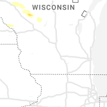
Wisconsin
| Local Time | Report Details |
|---|---|
| 5:06 PM CDT | Half Dollar sized hail reported near Webster, WI, 65.5 miles S of Duluth, MN |
| 5:07 PM CDT | Quarter sized hail reported near Webster, WI, 63.9 miles SSW of Duluth, MN, report via social media with photo. |
| 5:10 PM CDT | Golf Ball sized hail reported near Siren, WI, 68 miles S of Duluth, MN, report with photo of ground completely covered with hail. largest hail stone estimated up to golf ball size. |
| 5:15 PM CDT | Golf Ball sized hail reported near Webster, WI, 65.4 miles S of Duluth, MN, report via social media with photo. |
| 5:15 PM CDT | Half Dollar sized hail reported near Siren, WI, 67.1 miles S of Duluth, MN |
| 5:24 PM CDT | Quarter sized hail reported near Siren, WI, 69.7 miles S of Duluth, MN, report from mping: quarter (1.00 in.). |
| 5:40 PM CDT | Quarter sized hail reported near Shell Lake, WI, 74.6 miles S of Duluth, MN, time of report is estimated by a combination of radar and spotter report. |
| 5:40 PM CDT | Spotter reports that several trees have been snapped. some trees were snapped near the base while others were snapped near the top. the one tree that was snapped near t in washburn county WI, 74.6 miles S of Duluth, MN |
| 5:50 PM CDT | Half Dollar sized hail reported near Rice Lake, WI, 82.9 miles ENE of Minneapolis, MN, report from mping: half dollar (1.25 in.). |
| 5:57 PM CDT | Quarter sized hail reported near Sarona, WI, 75.4 miles S of Duluth, MN, report via social media with photo. |
| 5:59 PM CDT | Hen Egg sized hail reported near Shell Lake, WI, 75.4 miles S of Duluth, MN, hail damage includes severe damage to garden and trees. possible damage to cars and roof. |
| 6:00 PM CDT | 40 foot tall trees reported down on the north side of rice lak in barron county WI, 83.1 miles ENE of Minneapolis, MN |
| 6:08 PM CDT | Ping Pong Ball sized hail reported near Barronett, WI, 78.7 miles NE of Minneapolis, MN, report via social media with photo. |
| 6:08 PM CDT | Golf Ball sized hail reported near Rice Lake, WI, 82.9 miles ENE of Minneapolis, MN, lots of golf ball sized hail falling for the past few minutes. |
| 6:10 PM CDT | Hen Egg sized hail reported near Rice Lake, WI, 84.3 miles ENE of Minneapolis, MN, ground covered with hail up to 2 inches in diameter with time estimated based on radar. |
| 6:11 PM CDT | Tennis Ball sized hail reported near Rice Lake, WI, 80.4 miles ENE of Minneapolis, MN, hail up to tennis ball size with hail breaking through a large retailers roof. |
| 6:15 PM CDT | Golf Ball sized hail reported near Rice Lake, WI, 81.3 miles ENE of Minneapolis, MN |
| 6:54 PM CDT | Quarter sized hail reported near Weyerhaeuser, WI, 90.5 miles ENE of Minneapolis, MN |
| 7:03 PM CDT | Half Dollar sized hail reported near Chetek, WI, 92.5 miles ENE of Minneapolis, MN, half dollar sized hail in the township of rusk with time estimated based on radar. |
| 7:30 PM CDT | Scattered trees and power lines down across the southern half of st croix count in st. croix county WI, 43.9 miles E of Minneapolis, MN |
| 8:00 PM CDT | Time estimated based on rada in chippewa county WI, 87.3 miles E of Minneapolis, MN |
| 8:00 PM CDT | Numerous large tree branches snapped around town. some branches look to be at least 8 inches in diamete in dunn county WI, 65.8 miles E of Minneapolis, MN |
| 8:10 PM CDT | Large tree limbs reported down in menomonie... some of which were 8 inches in diameter. menomonie awos... east of town... measured 53 mph at 815 p in dunn county WI, 65.8 miles E of Minneapolis, MN |
| 8:30 PM CDT | Report from arx of spotter report on the chippewa and taylor county lin in chippewa county WI, 80.9 miles WSW of Rhinelander, WI |
| 8:31 PM CDT | Storm damage reported in taylor county WI, 80.2 miles WSW of Rhinelander, WI |
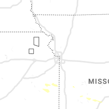
Kansas
| Local Time | Report Details |
|---|---|
| 4:25 PM MDT | Off duty nws employee reports large tree limb down. time estimate in sherman county KS, 36.3 miles W of Colby, KS |
| 6:05 PM CDT | Trained spotter reports winds estimated in excess of 60 mp in thomas county KS, 18 miles W of Colby, KS |
| 6:05 PM CDT | Trained spotter reports winds estimated in excess of 60 mp in thomas county KS, 18 miles W of Colby, KS |
| 5:11 PM MDT | Reports received of 4 semis overturned on i-70 around mm 35 near brewste in sherman county KS, 19.6 miles WSW of Colby, KS |
| 6:25 PM CDT | Public report of 12 power poles snapped off near road 9 and road s northwest of levant. also a big blue spruce tree was uprooted. time estimate in thomas county KS, 10.4 miles W of Colby, KS |
| 6:29 PM CDT | Awos station kcbk 2 n colb in thomas county KS, 2.3 miles N of Colby, KS |
| 7:02 PM CDT | Quarter sized hail reported near Selden, KS, 27.2 miles ENE of Colby, KS, law enforcement reports hail up to quarter size or larger in selden. time estimated from radar. |
| 7:04 PM CDT | Storm damage reported in sheridan county KS, 27.2 miles ENE of Colby, KS |
| 7:41 PM CDT | Quarter sized hail reported near Atwood, KS, 20.9 miles N of Colby, KS, spotter reports quarter size hail... covering hwy 25 near mm 215. |
| 7:45 PM CDT | Quarter sized hail reported near Oberlin, KS, 33.3 miles NE of Colby, KS, trained spotter reports hail up to quarter size with photo sent via social media. |
Nebraska
| Local Time | Report Details |
|---|---|
| 4:45 PM MDT | Golf Ball sized hail reported near Morrill, NE, 24.6 miles NW of Scottsbluff, NE, corrects previous hail report from 5 n henry. photo shows ground covered in ping pong to golf ball hail stones. |
| 5:01 PM MDT | Hen Egg sized hail reported near Morrill, NE, 23.1 miles NW of Scottsbluff, NE |
| 5:05 PM MDT | Tennis Ball sized hail reported near Morrill, NE, 23.1 miles NW of Scottsbluff, NE |
| 6:07 PM CDT | Quarter sized hail reported near Stratton, NE, 47.5 miles NNW of Colby, KS, trained spotter report of nickel to dime size hail. time estimated from radar. |
| 5:45 PM MDT | Quarter sized hail reported near Morrill, NE, 18.5 miles NW of Scottsbluff, NE |
| 5:45 PM MDT | Golf Ball sized hail reported near Morrill, NE, 24.6 miles NW of Scottsbluff, NE, photo shows ground covered in ping pong to golfball hail stones. |
| 7:02 PM CDT | Quarter sized hail reported near Bloomfield, NE, 53.1 miles ENE of Oneill, NE, estimated due to hail ongoing. |
| 6:15 PM MDT | Half Dollar sized hail reported near Mitchell, NE, 26.5 miles NNW of Scottsbluff, NE, mping report. |
Utah
| Local Time | Report Details |
|---|---|
| 5:00 PM MDT | Mesonet station dpg21 simpson sprin in tooele county UT, 80.2 miles SW of Salt Lake City, UT |
| 5:10 PM MDT | Mesonet station utsto sr-36 at mp 49 stockton ba in tooele county UT, 31.5 miles SW of Salt Lake City, UT |
| 5:20 PM MDT | Mesonet station dpg06 camel back mt in tooele county UT, 71.3 miles SW of Salt Lake City, UT |
| 5:26 PM MDT | Quarter sized hail reported near Tooele, UT, 26.8 miles SW of Salt Lake City, UT |
| 5:44 PM MDT | Half Dollar sized hail reported near Tooele, UT, 26.4 miles SW of Salt Lake City, UT |
| 6:20 PM MDT | Mesonet station pc104 grantsville sout in tooele county UT, 34 miles WSW of Salt Lake City, UT |
| 6:45 PM MDT | Mesonet station kcc02 marin in salt lake county UT, 16.5 miles W of Salt Lake City, UT |
| 6:50 PM MDT | Mesonet station ut201 sr-201 at i-8 in tooele county UT, 18.2 miles W of Salt Lake City, UT |
| 7:00 PM MDT | Mesonet station snd arrowhead summi in utah county UT, 31.1 miles SSE of Salt Lake City, UT |
| 7:00 PM MDT | Mesonet station pc034 provo canyo in utah county UT, 32.7 miles SSE of Salt Lake City, UT |
| 7:10 PM MDT | Mesonet station snd arrowhead summi in utah county UT, 31.1 miles SSE of Salt Lake City, UT |
| 7:16 PM MDT | Mesonet station uupya uofu playa research sit in davis county UT, 22.3 miles NNW of Salt Lake City, UT |
| 7:33 PM MDT | Asos station kogd ogden-hinckley airpor in weber county UT, 31.2 miles NNW of Salt Lake City, UT |
Pennsylvania
| Local Time | Report Details |
|---|---|
| 8:35 PM EDT | Widespread trees down across the cit in york county PA, 46.6 miles N of Baltimore, MD |
| 8:45 PM EDT | Trees on wire in york county PA, 42.8 miles N of Baltimore, MD |
| 8:45 PM EDT | Damage to chimney and roo in york county PA, 47.2 miles N of Baltimore, MD |
Connect with Interactive Hail Maps