

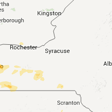
Hail Map for Monday, July 25, 2011

Number of Impacted Households on 7/25/2011
0
Impacted by 1" or Larger Hail
0
Impacted by 1.75" or Larger Hail
0
Impacted by 2.5" or Larger Hail
Square Miles of Populated Area Impacted on 7/25/2011
0
Impacted by 1" or Larger Hail
0
Impacted by 1.75" or Larger Hail
0
Impacted by 2.5" or Larger Hail


Cities Most Affected by Hail Storms of 7/25/2011
| Hail Size | Demographics of Zip Codes Affected | ||||||
|---|---|---|---|---|---|---|---|
| City | Count | Average | Largest | Pop Density | House Value | Income | Age |
| Rapid City, SD | 3 | 2.08 | 2.75 | 111 | $119k | $47.4k | 44.3 |
| Bigfork, MT | 3 | 2.00 | 2.00 | 18 | $164k | $35.1k | 51.4 |
| Pine Ridge, SD | 1 | 1.75 | 1.75 | 0 | $21k | $20.8k | 23.5 |
| Rapid River, MI | 1 | 1.75 | 1.75 | 8 | $92k | $36.2k | 51.4 |
| Keystone, SD | 1 | 1.75 | 1.75 | 9 | $97k | $31.4k | 50.6 |
| Jordan, MT | 1 | 1.75 | 1.75 | 0 | $36k | $25.3k | 47.4 |
Hail and Wind Damage Spotted on 7/25/2011
Filter by Report Type:Hail ReportsWind Reports
States Impacted
New York, Pennsylvania, Virginia, Florida, North Carolina, Tennessee, Maryland, Arkansas, Texas, Missouri, South Dakota, Michigan, Oklahoma, Minnesota, Montana, Georgia, South Carolina, Iowa, Mississippi, Louisiana, NebraskaNew York
| Local Time | Report Details |
|---|---|
| 2:43 PM UTC | Numerous trees down in a half mile wide swath from the intersection of 20a and transit road...southeast through the city in erie county NY, 15.4 miles ESE of Buffalo, NY |
| 2:50 PM UTC | Quarter sized hail reported near East Aurora, NY, 15.4 miles ESE of Buffalo, NY, east aurora police reported hail accumulated in the city |
| 2:55 PM UTC | Quarter sized hail reported near East Aurora, NY, 15.4 miles ESE of Buffalo, NY, public report of hail |
| 3:05 PM UTC | Row of trees on rt 16 in erie county NY, 31.2 miles SE of Buffalo, NY |
| 3:05 PM UTC | Row of trees on rt 16 between holland and chaffee in erie county NY, 28.9 miles SE of Buffalo, NY |
| 3:30 PM UTC | Two reports of trees down in fredonia...one blocking road...the other a 10 foot high tree in chautauqua county NY, 38.4 miles SW of Buffalo, NY |
| 4:43 PM UTC | Multiple trees down in cattaraugus county NY, 50.9 miles S of Buffalo, NY |
| 4:45 PM UTC | Storm damage reported in schuyler county NY, 52.3 miles SW of Syracuse, NY |
| 5:19 PM UTC | Multiple trees dow in allegany county NY, 66.9 miles SSE of Buffalo, NY |
| 5:28 PM UTC | Multiple trees dow in allegany county NY, 73.8 miles SE of Buffalo, NY |
| 5:40 PM UTC | Few trees and wires down in southern part of county in tompkins county NY, 51.2 miles SSW of Syracuse, NY |
| 5:55 PM UTC | Few trees down in tioga county NY, 57.4 miles S of Syracuse, NY |
| 6:04 PM UTC | Limb fell on car in chemung county NY, 70 miles SSW of Syracuse, NY |
| 6:40 PM UTC | Trees and wires down and also in endwell...vestal... binghamton...and kirkwood. structures hit by lightnin in broome county NY, 52.7 miles NNW of Scranton, PA |
Pennsylvania
| Local Time | Report Details |
|---|---|
| 5:30 PM UTC | Numerous trees and wires down in shinglehouse in potter county PA, 72.3 miles SSE of Buffalo, NY |
| 6:00 PM UTC | Numerous trees and wires down in roulette in potter county PA, 69.2 miles NNW of State College, PA |
| 7:50 PM UTC | Two cars flipped over and damage to a home improvement center in mill hall in clinton county PA, 28.7 miles NE of State College, PA |
| 9:15 PM UTC | Wires down in scott township in columbia county PA, 50.4 miles SW of Scranton, PA |
| 9:15 PM UTC | In the edwardsville larksville area...several hundred trees down in a 2 square mile area. trees were of several types from birch to oak and sizes and all appeared were in luzerne county PA, 17.4 miles SW of Scranton, PA |
| 9:15 PM UTC | Numerous large trees and powerlines down through town. several trees uprooted along with damage to several building along state street in town. one house on state stree in luzerne county PA, 17.4 miles SW of Scranton, PA |
| 9:20 PM UTC | Numerouns trees down in kingston...also in the larksville are in luzerne county PA, 15.8 miles SW of Scranton, PA |
| 9:20 PM UTC | Tree down in pike county PA, 25 miles E of Scranton, PA |
Virginia
| Local Time | Report Details |
|---|---|
| 5:55 PM UTC | Windows blown out of a structure. tree damage also note in nelson county VA, 70.4 miles NE of Roanoke, VA |
| 7:02 PM UTC | Several branches 4 inch or larger broken and downed along 6 mile post roa in franklin county VA, 20.2 miles S of Roanoke, VA |
| 7:32 PM UTC | Large tree limb down on state route 790...plantation roa in buckingham county VA, 50.5 miles W of Richmond, VA |
| 7:32 PM UTC | Tree down on route 4 in franklin county VA, 23.8 miles SE of Roanoke, VA |
| 7:44 PM UTC | Large tree down across andersonville roa in buckingham county VA, 48.3 miles W of Richmond, VA |
| 7:45 PM UTC | The buckingham county sheriffs office reported a tree blown down on dixie hill road near the community of andersonvill in buckingham county VA, 50.5 miles W of Richmond, VA |
| 8:45 PM UTC | Tree down on lowery roa in halifax county VA, 59.2 miles N of Raleigh, NC |
| 8:56 PM UTC | Trees down on powerline in halifax county VA, 58.5 miles N of Raleigh, NC |
| 9:15 PM UTC | Several reports of trees down in and around tappahannoc in essex county VA, 51.5 miles NE of Richmond, VA |
| 10:02 PM UTC | Tree down on state route 61 in mecklenburg county VA, 62.4 miles NNE of Raleigh, NC |
| 10:32 PM UTC | Tree down vicinty of rivers reach subdivision in king and queen county VA, 43.9 miles ENE of Richmond, VA |
| 10:35 PM UTC | Trees down on state route 65 in dinwiddie county VA, 34.3 miles S of Richmond, VA |
| 11:25 PM UTC | Trees down on optimist roa in sussex county VA, 44.8 miles SSE of Richmond, VA |
| 11:50 PM UTC | Tree downed on jefferson avenue...near old williamsburg road intersectio in city of newport ne county VA, 43 miles NW of Virginia Beach, VA |
| 11:50 PM UTC | Tree down on house. house sustained significant damag in james city county VA, 51.2 miles NW of Virginia Beach, VA |
| 12:00 AM UTC | Tree fell down on rte 258...blocking the north bound lane in isle of wight county VA, 37.1 miles WNW of Virginia Beach, VA |
| 12:26 AM UTC | Power lines downed by tstm wind in city of portsmouth county VA, 20.6 miles WNW of Virginia Beach, VA |
| 12:50 AM UTC | Tree down on fleet c in city of portsmouth county VA, 20.8 miles WNW of Virginia Beach, VA |
Florida
| Local Time | Report Details |
|---|---|
| 6:15 PM UTC | 911 call center confirmed that several trees and powerlines were down across the count in bradford county FL, 37.8 miles SW of Jacksonville, FL |
| 7:04 PM UTC | The orange park police reported a large tree blown down and blocking the road at the 800 block of kingsley avenu in clay county FL, 11.6 miles SSW of Jacksonville, FL |
| 7:10 PM UTC | The sheriffs office received reports of trees down near the palatka and san mateo areas. the time given was based on rada in putnam county FL, 49.9 miles S of Jacksonville, FL |
| 7:15 PM UTC | The duval county fire rescue received sporatic reports of powelines line in the city including san marco and avendale. the time given was based on rada in duval county FL, 3.4 miles SW of Jacksonville, FL |
| 7:30 PM UTC | 911 call center relayed a public report of wind damage that included several trees down near county road 210 just west of interstate 95. hail of unknown size was also r in st. johns county FL, 20.6 miles SSE of Jacksonville, FL |
| 8:10 PM UTC | Trained spotter report of trees down on burning bush drive in palm coast. also reported estimated wind gusts around 50 mph and marble size hai in flagler county FL, 57.2 miles SSE of Jacksonville, FL |
North Carolina
| Local Time | Report Details |
|---|---|
| 6:53 PM UTC | Roof blown off apartment building on weymouth street in durham in durham county NC, 21.4 miles NW of Raleigh, NC |
| 6:53 PM UTC | Trees down on shannon rd near mlk parkway in durham county NC, 21.5 miles NW of Raleigh, NC |
| 8:50 PM UTC | Tree down near the intersection of arbor green drive and nc 5 in wake county NC, 9.5 miles S of Raleigh, NC |
| 8:50 PM UTC | One tree blown down on mebane oaks road. time estimate in alamance county NC, 37.7 miles WNW of Raleigh, NC |
| 8:50 PM UTC | 1 tree down along ten ten rd. time and location estimate in wake county NC, 8.8 miles S of Raleigh, NC |
| 9:05 PM UTC | One tree blown down. time estimate in orange county NC, 33.4 miles WNW of Raleigh, NC |
| 9:25 PM UTC | Down power-lines due to tree limbs falling down onto them at 1846 green valley lane. one other tree also reported down near red oa in nash county NC, 44.5 miles ENE of Raleigh, NC |
| 9:25 PM UTC | Very large tree limb down neear trail stream way and linwood driv in wake county NC, 6.9 miles E of Raleigh, NC |
| 9:30 PM UTC | 30 inch dialeter tree blown across powerlines on murphrey road in johnston county NC, 16.8 miles ESE of Raleigh, NC |
| 9:30 PM UTC | Tree down near archers lodge off wendell road in johnston county NC, 16.7 miles ESE of Raleigh, NC |
| 9:48 PM UTC | Tree down on nc 97 near cool spring road in edgecombe county NC, 53.5 miles ENE of Raleigh, NC |
| 10:07 PM UTC | 1 tree down off hwy 205 and ansonville rd north of marshvill in union county NC, 29.3 miles ESE of Charlotte, NC |
| 10:10 PM UTC | 1 tree down and blocking roadway on camden rd just south of marshvill in union county NC, 31.7 miles ESE of Charlotte, NC |
| 10:11 PM UTC | Tree down on 64 between spring hope and the franklin county lin in nash county NC, 29.4 miles ENE of Raleigh, NC |
| 10:16 PM UTC | Tree down on east lacawanna s in anson county NC, 36.1 miles ESE of Charlotte, NC |
| 10:16 PM UTC | Tree down on spring church rd in peachlan in anson county NC, 35.6 miles ESE of Charlotte, NC |
| 10:16 PM UTC | Tree down on drye rd in burnsvill in anson county NC, 32.8 miles E of Charlotte, NC |
Tennessee
| Local Time | Report Details |
|---|---|
| 7:20 PM UTC | A few trees and power lines down. reported by dispatc in roane county TN, 36.4 miles WSW of Knoxville, TN |
Maryland
| Local Time | Report Details |
|---|---|
| 7:55 PM UTC | Couple of tree limbs down on and around harwood road at sands roa in anne arundel county MD, 27.8 miles S of Baltimore, MD |
| 9:00 PM UTC | Trees down on rt 50w in wicomico county MD, 27.6 miles W of Ocean City, MD |
Arkansas
| Local Time | Report Details |
|---|---|
| 8:00 PM UTC | Trees reported down along hwy in saline county AR, 29.6 miles WSW of Little Rock, AR |
| 8:35 PM UTC | Large limbs down across several roads in and around hop in hempstead county AR, 24.2 miles SE of Nashville, AR |
| 8:50 PM UTC | Several trees reported down along hwy 298 and hwy in saline county AR, 22.4 miles WSW of Little Rock, AR |
| 10:06 PM UTC | Small tree down on n main and s bradley streets in warren. small piece of roof blown off of piggly wiggly store in warre in bradley county AR, 58 miles N of Bastrop, LA |
| 10:11 PM UTC | Thunderstorm wind knocked down a tree on county road 20. road was impassable for short period of tim in calhoun county AR, 59.5 miles NW of Bastrop, LA |
| 11:25 PM UTC | Trees down along highway 167 sout in union county AR, 48 miles WNW of Bastrop, LA |
Texas
| Local Time | Report Details |
|---|---|
| 8:15 PM UTC | Two trees were downed blocking a road in the hooks area. time is approximat in bowie county TX, 41.7 miles SW of Nashville, AR |
| 9:30 PM UTC | Trees reported down near the town of mariett in cass county TX, 64.5 miles NW of Shreveport, LA |
| 10:35 PM UTC | Storm damage reported in wood county TX, 76.4 miles E of Dallas, TX |
Missouri
| Local Time | Report Details |
|---|---|
| 8:15 PM UTC | Tree down. powerline dow in vernon county MO, 61.3 miles E of Chanute, KS |
| 8:20 PM UTC | Knvd awo in vernon county MO, 64.1 miles E of Chanute, KS |
| 9:23 PM UTC | Severe thunderstorm wind gusts downed a few tree limbs just south of lama in barton county MO, 57.5 miles WNW of Springfield, MO |
| 10:38 PM UTC | Severe thunderstorm wind gusts knocked guttering off of a house. the ham radio operator estimated greater than 60 mph wind gusts with this stor in jasper county MO, 62.2 miles W of Springfield, MO |
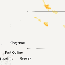
South Dakota
| Local Time | Report Details |
|---|---|
| 8:29 PM UTC | Quarter sized hail reported near Rapid City, SD, 10.4 miles W of Rapid City, SD |
| 8:42 PM UTC | Golf Ball sized hail reported near Rapid City, SD, 12.5 miles W of Rapid City, SD |
| 8:50 PM UTC | Golf Ball sized hail reported near Rapid City, SD, 8.5 miles W of Rapid City, SD, much 1/2 inch hail. some 1 3/4 inch. |
| 8:50 PM UTC | Baseball sized hail reported near Rapid City, SD, 12.4 miles W of Rapid City, SD |
| 9:12 PM UTC | Golf Ball sized hail reported near Keystone, SD, 15.4 miles SSW of Rapid City, SD, at least 10 minutes of golf ball sized hail |
| 9:18 PM UTC | Ping Pong Ball sized hail reported near Rapid City, SD, 8.4 miles W of Rapid City, SD |
| 9:30 PM UTC | Quarter sized hail reported near Hermosa, SD, 15.6 miles S of Rapid City, SD, mostly marble...max quarter sized hail |
| 9:50 PM UTC | 9 inch diameter tree top broken off. pea sized hail in custer county SD, 18.8 miles S of Rapid City, SD |
| 10:10 PM UTC | Storm damage reported in pennington county SD, 39.9 miles E of Rapid City, SD |
| 10:25 PM UTC | Quarter sized hail reported near Spearfish, SD, 48.7 miles NW of Rapid City, SD |
| 10:26 PM UTC | Pea hail and heavy rain in custer county SD, 16.8 miles S of Rapid City, SD |
| 10:29 PM UTC | Storm damage reported in harding county SD, 96.4 miles NNW of Rapid City, SD |
| 10:50 PM UTC | Kelo mesonet site in pennington county SD, 49.8 miles E of Rapid City, SD |
| 11:00 PM UTC | Storm damage reported in harding county SD, 96.4 miles NNW of Rapid City, SD |
| 11:22 PM UTC | Quarter sized hail reported near Newell, SD, 78.4 miles N of Rapid City, SD |
| 11:30 PM UTC | Storm damage reported in jackson county SD, 67 miles ESE of Rapid City, SD |
| 11:30 PM UTC | Storm damage reported in shannon county SD, 64.5 miles SE of Rapid City, SD |
| 11:31 PM UTC | Storm damage reported in jackson county SD, 67 miles ESE of Rapid City, SD |
| 11:33 PM UTC | Storm damage reported in jackson county SD, 72.8 miles ESE of Rapid City, SD |
| 11:33 PM UTC | Quarter sized hail reported near Newell, SD, 68.2 miles N of Rapid City, SD |
| 11:39 PM UTC | Storm damage reported in jackson county SD, 67 miles ESE of Rapid City, SD |
| 11:40 PM UTC | Quarter sized hail reported near Faith, SD, 73.7 miles NNE of Rapid City, SD, pea to ping pong ball hail from 540 pm to 630 pm. |
| 11:45 PM UTC | Quarter sized hail reported near Mud Butte, SD, 70.5 miles NNE of Rapid City, SD |
| 11:45 PM UTC | Golf Ball sized hail reported near Pine Ridge, SD, 58.7 miles SSE of Rapid City, SD |
| 11:48 PM UTC | Storm damage reported in harding county SD, 106 miles N of Rapid City, SD |
| 11:50 PM UTC | Storm damage reported in harding county SD, 106 miles N of Rapid City, SD |
| 12:10 AM UTC | Storm damage reported in shannon county SD, 67.1 miles SSE of Rapid City, SD |
| 12:15 AM UTC | 55-60 mph win in jackson county SD, 73.8 miles NW of Valentine, NE |
| 12:15 AM UTC | 55-60 mp in bennett county SD, 71.8 miles WNW of Valentine, NE |
| 12:22 AM UTC | Storm damage reported in jackson county SD, 66.3 miles NW of Valentine, NE |
| 12:43 AM UTC | Storm damage reported in ziebach county SD, 82.7 miles WNW of Pierre, SD |
| 12:43 AM UTC | Storm damage reported in meade county SD, 75.3 miles NE of Rapid City, SD |
| 12:45 AM UTC | Storm damage reported in bennett county SD, 76.1 miles WNW of Valentine, NE |
| 12:47 AM UTC | Storm damage reported in perkins county SD, 103.4 miles NNE of Rapid City, SD |
| 1:00 AM UTC | Storm damage reported in jackson county SD, 58.1 miles NW of Valentine, NE |
| 1:08 AM UTC | Storm damage reported in perkins county SD, 89.2 miles NE of Rapid City, SD |
| 1:30 AM UTC | Storm damage reported in minnehaha county SD, 16.7 miles NE of Sioux Falls, SD |
| 1:42 AM UTC | Quarter sized hail reported near Garretson, SD, 16.7 miles NE of Sioux Falls, SD |
| 1:45 AM UTC | 2-3 inch diameter tree branches blown down by severe thunderstorm wind gusts. rainfall estimated at 1-2 inches is causing street flooding. quarter sized hail earlier st in minnehaha county SD, 16.7 miles NE of Sioux Falls, SD |
Michigan
| Local Time | Report Details |
|---|---|
| 8:55 PM UTC | Golf Ball sized hail reported near Masonville, MI, 40.9 miles SSE of Marquette, MI, also reported downed trees along road due to excessive winds during the same time. |
Oklahoma
| Local Time | Report Details |
|---|---|
| 9:20 PM UTC | Time estimated via rada in caddo county OK, 42.1 miles SW of Oklahoma City, OK |
| 10:42 PM UTC | Quarter sized hail reported near Weatherford, OK, 70.6 miles W of Oklahoma City, OK, spotter also estimated 70 mph wind gust northwest of weatherford. |
| 10:45 PM UTC | Numerous reports of wind damage in and near weatherford between 545-610 pm. widespread power line and transmission pole damage...large trees uprooted or snapped. fd est in custer county OK, 66.6 miles W of Oklahoma City, OK |
| 11:30 PM UTC | Storm damage reported in blaine county OK, 59.1 miles W of Oklahoma City, OK |
Minnesota
| Local Time | Report Details |
|---|---|
| 9:23 PM UTC | Quarter sized hail reported near Lynd, MN, 39 miles SSW of Montevideo, MN |
| 11:00 PM UTC | Quarter sized hail reported near Avoca, MN, 60.9 miles ENE of Sioux Falls, SD |
| 11:27 PM UTC | Quarter sized hail reported near Avoca, MN, 60.9 miles ENE of Sioux Falls, SD, in addition to hail estimated at 1 inch in dia |
| 11:48 PM UTC | Ping Pong Ball sized hail reported near Brewster, MN, 63 miles ENE of Sioux Falls, SD |
| 11:53 PM UTC | Quarter sized hail reported near Worthington, MN, 57.9 miles ENE of Sioux Falls, SD |
| 2:13 AM UTC | Quarter sized hail reported near Pipestone, MN, 42.1 miles NNE of Sioux Falls, SD |
| 2:45 AM UTC | Half Dollar sized hail reported near Holland, MN, 48.6 miles NNE of Sioux Falls, SD |
Montana
| Local Time | Report Details |
|---|---|
| 9:30 PM UTC | Quarter sized hail reported near Broadus, MT, 74 miles SSE of Miles City, MT |
| 9:30 PM UTC | Ping Pong Ball sized hail reported near Broadus, MT, 71.1 miles SSE of Miles City, MT |
| 9:32 PM UTC | Storm damage reported in carter county MT, 82.8 miles SE of Miles City, MT |
| 9:40 PM UTC | Tree tops torn off and could feel the house shak in carter county MT, 75.3 miles NNE of Gillette, WY |
| 9:40 PM UTC | Tree tops torn off and could feel the house shak in carter county MT, 69.4 miles NNE of Gillette, WY |
| 9:50 PM UTC | Downburst type winds downed 6 to 8 inch diameter limbs off a cottonwood tre in carter county MT, 69.4 miles NNE of Gillette, WY |
| 10:00 PM UTC | Winds briefly gusted to 61 mph as thunderstorms passed through. crooked coulee sit in toole county MT, 73 miles N of Great Falls, MT |
| 10:30 PM UTC | North galat in toole county MT, 72.1 miles N of Great Falls, MT |
| 10:41 PM UTC | Quarter sized hail reported near Olive, MT, 61.6 miles SSE of Miles City, MT |
| 10:41 PM UTC | Quarter sized hail reported near Olive, MT, 59.7 miles SSE of Miles City, MT |
| 11:06 PM UTC | Quarter sized hail reported near Volborg, MT, 36.8 miles SE of Miles City, MT, wind driven hail and very heavy rainfall |
| 12:00 AM UTC | Quarter sized hail reported near Marion, MT, 28.8 miles SW of Whitefish, MT, 1 inch hail covering ground at mcgregor lake campground |
| 1:35 AM UTC | Storm damage reported in phillips county MT, 55.8 miles WSW of Glasgow, MT |
| 1:55 AM UTC | Quarter sized hail reported near Big Arm, MT, 42.2 miles S of Whitefish, MT, 1 inch size |
| 2:10 AM UTC | Hen Egg sized hail reported near Bigfork, MT, 40.7 miles SSE of Whitefish, MT, 2 inch diameter hail fell for a duration of three minutes at yellow bay |
| 2:10 AM UTC | Hen Egg sized hail reported near Bigfork, MT, 40 miles SSE of Whitefish, MT, 2 inch diameter hail fell for a duration of three minutes at yellow bay |
| 2:12 AM UTC | Ping Pong Ball sized hail reported near Bigfork, MT, 40.7 miles SSE of Whitefish, MT, ping pong ball size hail measured at yellow bay. |
| 2:12 AM UTC | Ping Pong Ball sized hail reported near Bigfork, MT, 40.8 miles SSE of Whitefish, MT, ping pong ball size hail measured at yellow bay. |
| 2:15 AM UTC | Golf Ball sized hail reported near Jordan, MT, 60.5 miles SSW of Glasgow, MT, also estimated 50-60 mph winds. |
| 2:25 AM UTC | Quarter sized hail reported near Jordan, MT, 52.2 miles SSW of Glasgow, MT, also reported 60 mph winds |
| 2:30 AM UTC | Half Dollar sized hail reported near Jordan, MT, 53 miles SSW of Glasgow, MT, also reported 60 mph wind gusts |
| 3:38 AM UTC | Hen Egg sized hail reported near Bigfork, MT, 40.7 miles SSE of Whitefish, MT, 2 inch diameter hail fell for a duration of three minutes at yellow bay |
| 3:40 AM UTC | Storm damage reported in mccone county MT, 63.1 miles SSE of Glasgow, MT |
| 4:00 AM UTC | Strong winds tore siding off of a house in daniels county MT, 74.3 miles NE of Glasgow, MT |
Georgia
| Local Time | Report Details |
|---|---|
| 9:36 PM UTC | Cherokee county ema relayed a report of a tree down across the road nne of canto in cherokee county GA, 37.5 miles N of Atlanta, GA |
South Carolina
| Local Time | Report Details |
|---|---|
| 10:40 PM UTC | Tree down at south bennetts bridge rd and thompson rd. time estimated from rada in greenville county SC, 21.1 miles E of Greenville, SC |
| 10:45 PM UTC | 1 large limb down on dobson rd just north of reidville. estimated max diameter of limb was about 8 inche in spartanburg county SC, 28.2 miles E of Greenville, SC |
| 11:00 PM UTC | 2 trees down at wofford road and grace chapel road. time estimated from rada in spartanburg county SC, 37.9 miles ESE of Greenville, SC |
| 11:30 PM UTC | Tree down at lockhart hwy and philippi church road. time estimated from rada in union county SC, 51.5 miles SW of Charlotte, NC |
| 11:40 PM UTC | Tree down on the 300 block of adams lake road. time estimated from rada in union county SC, 48.4 miles SW of Charlotte, NC |
Iowa
| Local Time | Report Details |
|---|---|
| 11:00 PM UTC | Quarter sized hail reported near Avoca, IA, 34.7 miles ENE of Omaha, NE |
Mississippi
| Local Time | Report Details |
|---|---|
| 11:30 PM UTC | Tree limbs down in indianol in sunflower county MS, 83.7 miles NNW of Jackson, MS |
| 11:58 PM UTC | Snapped power pole at an apartment complex in town in leflore county MS, 79.6 miles W of Starkville, MS |
Louisiana
| Local Time | Report Details |
|---|---|
| 11:55 PM UTC | Trees down in mario in union county LA, 20.7 miles WNW of Bastrop, LA |
| 12:04 AM UTC | Trees reported down southeast of farmerville near francis cree in union county LA, 27.1 miles W of Bastrop, LA |
Nebraska
| Local Time | Report Details |
|---|---|
| 12:08 AM UTC | Quarter sized hail reported near Crawford, NE, 58.6 miles NNE of Scottsbluff, NE, dime to quarter size hail. |
| 12:30 AM UTC | Quarter sized hail reported near Crawford, NE, 58.6 miles NNE of Scottsbluff, NE |
| 2:52 AM UTC | Quarter sized hail reported near Alliance, NE, 57.1 miles ENE of Scottsbluff, NE |
Connect with Interactive Hail Maps