

Hail Map for Friday, July 29, 2016

Number of Impacted Households on 7/29/2016
0
Impacted by 1" or Larger Hail
0
Impacted by 1.75" or Larger Hail
0
Impacted by 2.5" or Larger Hail
Square Miles of Populated Area Impacted on 7/29/2016
0
Impacted by 1" or Larger Hail
0
Impacted by 1.75" or Larger Hail
0
Impacted by 2.5" or Larger Hail

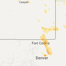


Cities Most Affected by Hail Storms of 7/29/2016
| Hail Size | Demographics of Zip Codes Affected | ||||||
|---|---|---|---|---|---|---|---|
| City | Count | Average | Largest | Pop Density | House Value | Income | Age |
| Greeley, CO | 5 | 1.85 | 2.00 | 521 | $121k | $32.7k | 27.5 |
| Cheyenne, WY | 4 | 2.06 | 2.75 | 52 | $115k | $44.8k | 38.3 |
| Lagrange, WY | 4 | 2.00 | 2.50 | 1 | $74k | $25.0k | 25.1 |
| La Salle, CO | 2 | 2.13 | 2.50 | 28 | $122k | $43.2k | 37.8 |
| Carr, CO | 2 | 1.88 | 2.00 | 2 | $33k | $36.1k | 44.6 |
| Nunn, CO | 2 | 1.75 | 1.75 | 4 | $104k | $41.1k | 41.3 |
| Ault, CO | 2 | 1.75 | 1.75 | 8 | $121k | $36.5k | 37.0 |
| Custer, SD | 1 | 2.75 | 2.75 | 8 | $92k | $36.7k | 51.5 |
| Fe Warren AFB, WY | 1 | 2.75 | 2.75 | 0 | $0k | $0.0k | 21.2 |
| Eaton, CO | 1 | 2.50 | 2.50 | 71 | $146k | $43.6k | 38.4 |
| Fort Lupton, CO | 1 | 2.00 | 2.00 | 95 | $139k | $45.4k | 35.3 |
| Hill City, SD | 1 | 1.75 | 1.75 | 3 | $97k | $36.2k | 47.3 |
| Pierce, CO | 1 | 1.75 | 1.75 | 13 | $108k | $39.9k | 39.3 |
Hail and Wind Damage Spotted on 7/29/2016
Filter by Report Type:Hail ReportsWind Reports
States Impacted
Indiana, South Dakota, Missouri, Arkansas, Wyoming, Colorado, New Mexico, Illinois, Tennessee, Nebraska, Arizona, California, TexasIndiana
| Local Time | Report Details |
|---|---|
| 1:20 PM CDT | Quarter sized hail reported near La Porte, IN, 51.3 miles ESE of Chicago, IL, time estimated from radar. |
| 2:20 PM CDT | Quarter sized hail reported near La Porte, IN, 51.3 miles ESE of Chicago, IL, time estimated from radar. |
South Dakota
| Local Time | Report Details |
|---|---|
| 1:24 PM MDT | Quarter sized hail reported near Rapid City, SD, 8.5 miles W of Rapid City, SD, mostly dime size |
| 1:50 PM MDT | Quarter sized hail reported near Buffalo Gap, SD, 39.1 miles S of Rapid City, SD |
| 3:35 PM MDT | Quarter sized hail reported near Keystone, SD, 15.7 miles SW of Rapid City, SD |
| 3:40 PM MDT | Quarter sized hail reported near Keystone, SD, 17.7 miles SW of Rapid City, SD |
| 3:45 PM MDT | Golf Ball sized hail reported near Hill City, SD, 22.7 miles SW of Rapid City, SD |
| 3:50 PM MDT | Baseball sized hail reported near Custer, SD, 23.4 miles SW of Rapid City, SD, relayed through mt coolidge comms |
| 4:09 PM MDT | Ping Pong Ball sized hail reported near Custer, SD, 23.1 miles SSW of Rapid City, SD |
| 4:10 PM MDT | Quarter sized hail reported near Custer, SD, 26.6 miles SSW of Rapid City, SD |
| 5:00 PM MDT | Quarter sized hail reported near Oral, SD, 45.7 miles S of Rapid City, SD |
| 5:00 PM MDT | Storm damage reported in fall river county SD, 45.7 miles S of Rapid City, SD |
| 5:07 PM MDT | Quarter sized hail reported near Owanka, SD, 35.6 miles ENE of Rapid City, SD |
Missouri
| Local Time | Report Details |
|---|---|
| 2:30 PM CDT | Limbs down. phone line wires into two homes dow in ozark county MO, 79.6 miles SE of Springfield, MO |
| 2:35 PM CDT | Severe thunderstorm wind gusts downed tree limbs on highway y in howell county MO, 80.1 miles SE of Springfield, MO |
Arkansas
| Local Time | Report Details |
|---|---|
| 2:55 PM CDT | Quarter sized hail reported near Salem, AR, 88.8 miles S of Salem, MO |
| 3:55 PM CDT | A tree was snapped near financial parkway and shacklefor in pulaski county AR, 6.6 miles W of Little Rock, AR |
| 4:25 PM CDT | Numerous trees and powerlines down along kerr rd north of interstate 4 in lonoke county AR, 14 miles ENE of Little Rock, AR |
| 7:00 PM CDT | Quarter sized hail reported near Mena, AR, 48 miles NNW of Nashville, AR, very strong winds also observed at time of report. |
| 8:10 PM CDT | A few powerlines were knocked down near north 10th stree in clark county AR, 47.2 miles ENE of Nashville, AR |
Wyoming
| Local Time | Report Details |
|---|---|
| 2:50 PM MDT | Golf Ball sized hail reported near Lagrange, WY, 31.4 miles WSW of Scottsbluff, NE, along highway 85. |
| 3:03 PM MDT | Golf Ball sized hail reported near Lagrange, WY, 29.9 miles WSW of Scottsbluff, NE |
| 3:03 PM MDT | Hen Egg sized hail reported near Lagrange, WY, 30.6 miles WSW of Scottsbluff, NE |
| 3:03 PM MDT | Tennis Ball sized hail reported near Lagrange, WY, 31.2 miles WSW of Scottsbluff, NE |
| 4:14 PM MDT | Hen Egg sized hail reported near Cheyenne, WY, 42.8 miles ESE of Laramie, WY |
| 4:15 PM MDT | Golf Ball sized hail reported near Cheyenne, WY, 42.8 miles ESE of Laramie, WY |
| 4:17 PM MDT | Quarter sized hail reported near Cheyenne, WY, 42.1 miles ESE of Laramie, WY |
| 4:18 PM MDT | Quarter sized hail reported near Cheyenne, WY, 43.1 miles ESE of Laramie, WY |
| 4:25 PM MDT | Baseball sized hail reported near Fe Warren AFB, WY, 39.1 miles ESE of Laramie, WY |
| 4:30 PM MDT | Baseball sized hail reported near Cheyenne, WY, 39.6 miles ESE of Laramie, WY, it estimated to fell between 4 to 430 pm. |
| 4:42 PM MDT | Half Dollar sized hail reported near Cheyenne, WY, 22.2 miles ESE of Laramie, WY |
| 4:46 PM MDT | Ping Pong Ball sized hail reported near Cheyenne, WY, 22.2 miles ESE of Laramie, WY |
| 4:48 PM MDT | Golf Ball sized hail reported near Cheyenne, WY, 43.1 miles ESE of Laramie, WY |
Colorado
| Local Time | Report Details |
|---|---|
| 3:05 PM MDT | Quarter sized hail reported near Cripple Creek, CO, 45.5 miles NW of Pueblo, CO, . |
| 5:33 PM MDT | Hen Egg sized hail reported near Carr, CO, 42.5 miles SE of Laramie, WY |
| 5:35 PM MDT | Golf Ball sized hail reported near Carr, CO, 53.8 miles SE of Laramie, WY |
| 5:35 PM MDT | Ping Pong Ball sized hail reported near Carr, CO, 47.1 miles SE of Laramie, WY |
| 6:26 PM MDT | Golf Ball sized hail reported near Nunn, CO, 57.7 miles SE of Laramie, WY |
| 6:28 PM MDT | Quarter sized hail reported near Carr, CO, 43.8 miles SE of Laramie, WY |
| 6:37 PM MDT | Golf Ball sized hail reported near Pierce, CO, 64.3 miles NNE of Denver, CO |
| 6:51 PM MDT | Golf Ball sized hail reported near Nunn, CO, 57.7 miles SE of Laramie, WY, second round of golfball sized tonight |
| 6:55 PM MDT | Half Dollar sized hail reported near Eaton, CO, 56.7 miles NNE of Denver, CO |
| 6:55 PM MDT | Ping Pong Ball sized hail reported near Eaton, CO, 55.9 miles NNE of Denver, CO |
| 6:56 PM MDT | Golf Ball sized hail reported near Ault, CO, 59.6 miles NNE of Denver, CO |
| 7:05 PM MDT | Golf Ball sized hail reported near Greeley, CO, 51.4 miles NNE of Denver, CO |
| 7:13 PM MDT | Golf Ball sized hail reported near Greeley, CO, 49.9 miles NNE of Denver, CO, at the greeley airport |
| 7:13 PM MDT | Golf Ball sized hail reported near Greeley, CO, 52 miles NNE of Denver, CO, at the greeley airport |
| 7:15 PM MDT | Hen Egg sized hail reported near Greeley, CO, 52 miles NNE of Denver, CO |
| 7:15 PM MDT | Hen Egg sized hail reported near Greeley, CO, 49.7 miles NNE of Denver, CO |
| 7:15 PM MDT | Tennis Ball sized hail reported near Eaton, CO, 56.7 miles NNE of Denver, CO, damaged car windows |
| 7:20 PM MDT | Large tree limb down on unc greeley. power lines down in ne greele in weld county CO, 48.8 miles NNE of Denver, CO |
| 7:25 PM MDT | Quarter sized hail reported near Greeley, CO, 49.1 miles NNE of Denver, CO |
| 7:26 PM MDT | Golf Ball sized hail reported near La Salle, CO, 41.5 miles NNE of Denver, CO |
| 7:35 PM MDT | Ping Pong Ball sized hail reported near Pierce, CO, 62.7 miles NNE of Denver, CO |
| 7:35 PM MDT | Tennis Ball sized hail reported near La Salle, CO, 39.7 miles NNE of Denver, CO |
| 8:45 PM MDT | Ping Pong Ball sized hail reported near Fort Lupton, CO, 24.7 miles NNE of Denver, CO |
| 8:55 PM MDT | Hen Egg sized hail reported near Fort Lupton, CO, 27.1 miles NNE of Denver, CO |
| 10:10 PM MDT | Golf Ball sized hail reported near Ault, CO, 60 miles NNE of Denver, CO |
| 12:23 AM MDT | Half Dollar sized hail reported near Roggen, CO, 44.4 miles NE of Denver, CO |
New Mexico
| Local Time | Report Details |
|---|---|
| 3:11 PM MDT | Kgup aso in mckinley county NM, 88 miles SSW of Farmington, NM |
Illinois
| Local Time | Report Details |
|---|---|
| 4:44 PM CDT | One large tree blown down on linden roa in winnebago county IL, 62.4 miles SSE of Madison, WI |
Tennessee
| Local Time | Report Details |
|---|---|
| 5:35 PM CDT | A large tree fell and broke through the roof of a home in the 700 block of honduras r in shelby county TN, 8.3 miles S of Memphis, TN |
Nebraska
| Local Time | Report Details |
|---|---|
| 4:42 PM MDT | Power pole snappe in morrill county NE, 30.4 miles SE of Scottsbluff, NE |
| 5:00 PM MDT | Storm damage reported in sheridan county NE, 87.9 miles W of Valentine, NE |
| 5:13 PM MDT | Ping Pong Ball sized hail reported near Gordon, NE, 72.3 miles W of Valentine, NE |
| 5:26 PM MDT | Ping Pong Ball sized hail reported near Gordon, NE, 70.9 miles W of Valentine, NE |
| 5:30 PM MDT | Ping Pong Ball sized hail reported near Gordon, NE, 74 miles W of Valentine, NE, pea to ping pong size hail covered ground. |
| 5:46 PM MDT | Half Dollar sized hail reported near Dalton, NE, 45.1 miles SE of Scottsbluff, NE |
| 6:35 PM MDT | Half Dollar sized hail reported near Sidney, NE, 60.3 miles SE of Scottsbluff, NE |
Arizona
| Local Time | Report Details |
|---|---|
| 4:14 PM MST | Estimated 60 to 70 mph winds and pea sized hai in yavapai county AZ, 38.2 miles SSW of Flagstaff, AZ |
| 4:34 PM MST | Estimated 60 to 70 mph winds and pea sized hai in yavapai county AZ, 38.2 miles SSW of Flagstaff, AZ |
| 4:36 PM MST | Storm damage reported in graham county AZ, 79 miles W of Silver City, NM |
| 4:37 PM MST | Estimated 60 to 70 mph wind in yavapai county AZ, 61.6 miles N of Phoenix, AZ |
| 4:53 PM MST | Peak gust reported on the 0453 pm observatio in graham county AZ, 80.8 miles S of Show Low, AZ |
| 5:30 PM MST | Wind gust reported on the 605 pm observation. time of gusts estimated by rada in pinal county AZ, 56.9 miles NNE of Tucson, AZ |
| 5:45 PM MST | Cover for scale blown down on ranc in pima county AZ, 9.5 miles SE of Tucson, AZ |
| 5:52 PM MST | Quarter sized hail reported near Mayer, AZ, 61.6 miles N of Phoenix, AZ, near spring valley north of cordes junction |
| 5:53 PM MST | 74 mph wind gust recorded on cwop site cw6532 in pima county AZ, 12.9 miles E of Tucson, AZ |
| 5:55 PM MST | Estimated 60 to 70 mph wind in yavapai county AZ, 61.6 miles N of Phoenix, AZ |
| 6:10 PM MST | Mesonet station 15 wnw sunflower /srp19 in maricopa county AZ, 42.3 miles NNE of Phoenix, AZ |
| 6:10 PM MST | Large tree down near intersection of ina and mona lisa r in pima county AZ, 8.2 miles N of Tucson, AZ |
| 6:15 PM MST | Damage to eeges restaurant at ina and thornydale. twitter report of 74 mph gust at ina and thornydale. time estimate in pima county AZ, 9.7 miles NNW of Tucson, AZ |
| 6:43 PM MST | Mesonet station 2 sse roosevelt /au919 in gila county AZ, 56.7 miles ENE of Phoenix, AZ |
| 7:55 PM MST | Awos station casa grande municipal airport /cgz in pinal county AZ, 38.6 miles SSE of Phoenix, AZ |
| 7:58 PM MST | Cover for scale blown down on ranc in pima county AZ, 9.5 miles SE of Tucson, AZ |
| 8:00 PM MST | Storm damage reported in maricopa county AZ, 22.4 miles SE of Phoenix, AZ |
| 8:00 PM MST | Local media reported at power poles down. pictures on social media confirmed at least one pole knocked down. in maricopa county AZ, 8.6 miles ENE of Phoenix, AZ |
| 8:10 PM MST | Mesonet station 4 se maricopa /up559 in pinal county AZ, 29.9 miles S of Phoenix, AZ |
| 8:15 PM MST | Mesonet station 4 wsw phoenix /srp32 in maricopa county AZ, 4.7 miles WSW of Phoenix, AZ |
| 8:15 PM MST | Asos station phoenix sky harbor intl arpt /phx in maricopa county AZ, 4.6 miles ESE of Phoenix, AZ |
| 8:40 PM MST | A few palo verde trees down and curb to curb flooding. time estimated based on radar. yuma road and watson r in maricopa county AZ, 28 miles W of Phoenix, AZ |
| 8:55 PM MST | Awos station 6 wnw buckeye /bxk in maricopa county AZ, 35.5 miles W of Phoenix, AZ |
| 9:01 PM MST | 2 ft diameter tree uproote in maricopa county AZ, 4.3 miles N of Phoenix, AZ |
| 9:03 PM MST | 3 trees blown down... 6 in diamete in maricopa county AZ, 11.3 miles ENE of Phoenix, AZ |
| 9:43 PM MST | Gila bend af aux field reported wind gusts of 89 mph. in maricopa county AZ, 54 miles SW of Phoenix, AZ |
California
| Local Time | Report Details |
|---|---|
| 4:43 PM PDT | California highway patrol reports a large tree on us 395 on the northwest side of bisho in inyo county CA, 86.5 miles ENE of Fresno, CA |
Texas
| Local Time | Report Details |
|---|---|
| 7:00 PM CDT | 4-6 inch diameter tree branches downed by strong wind gusts in dallam county TX, 77.2 miles NNE of Tucumcari, NM |
| 8:05 PM CDT | Storm damage reported in dallam county TX, 70.3 miles NNW of Amarillo, TX |
| 10:45 PM CDT | Sustained 40 mph. measured by the west tx mesone in parmer county TX, 61.9 miles SW of Amarillo, TX |
Connect with Interactive Hail Maps