

Hail Map for Wednesday, July 3, 2019

Number of Impacted Households on 7/3/2019
0
Impacted by 1" or Larger Hail
0
Impacted by 1.75" or Larger Hail
0
Impacted by 2.5" or Larger Hail
Square Miles of Populated Area Impacted on 7/3/2019
0
Impacted by 1" or Larger Hail
0
Impacted by 1.75" or Larger Hail
0
Impacted by 2.5" or Larger Hail


Cities Most Affected by Hail Storms of 7/3/2019
| Hail Size | Demographics of Zip Codes Affected | ||||||
|---|---|---|---|---|---|---|---|
| City | Count | Average | Largest | Pop Density | House Value | Income | Age |
| Kaycee, WY | 2 | 1.75 | 1.75 | 0 | $67k | $35.9k | 44.4 |
| Gillette, WY | 1 | 2.00 | 2.00 | 13 | $113k | $55.4k | 31.2 |
| Summerville, SC | 1 | 2.00 | 2.00 | 530 | $90k | $40.9k | 34.7 |
| Box Elder, SD | 1 | 1.75 | 1.75 | 45 | $66k | $32.6k | 30.1 |
| Hot Springs, SD | 1 | 1.75 | 1.75 | 11 | $63k | $30.3k | 50.7 |
| Batesland, SD | 1 | 1.75 | 1.75 | 1 | $31k | $7.1k | 29.8 |
| Kermit, TX | 1 | 1.75 | 1.75 | 16 | $29k | $29.6k | 34.5 |
| Buffalo Gap, SD | 1 | 1.75 | 1.75 | 0 | $45k | $29.9k | 50.6 |
| Kyle, SD | 1 | 1.75 | 1.75 | 0 | $27k | $23.9k | 24.1 |
| Edgemont, SD | 1 | 1.75 | 1.75 | 0 | $29k | $30.1k | 50.0 |
| Porcupine, SD | 1 | 1.75 | 1.75 | 1 | $36k | $23.0k | 23.6 |
Hail and Wind Damage Spotted on 7/3/2019
Filter by Report Type:Hail ReportsWind Reports
States Impacted
Idaho, South Dakota, North Carolina, Kentucky, Indiana, Iowa, Florida, Oklahoma, Illinois, South Carolina, North Dakota, Minnesota, Wisconsin, Texas, Nebraska, Kansas, Wyoming, TennesseeIdaho
| Local Time | Report Details |
|---|---|
| 6:15 AM PDT | Half Dollar sized hail reported near , , 61.9 miles E of Grangeville, ID, report is from spot mountain lookout. |
South Dakota
| Local Time | Report Details |
|---|---|
| 11:08 AM CDT | Half Dollar sized hail reported near Salem, SD, 33.3 miles WNW of Sioux Falls, SD |
| 11:15 AM CDT | Quarter sized hail reported near Canova, SD, 39.1 miles NW of Sioux Falls, SD |
| 11:17 AM CDT | Quarter sized hail reported near Winfred, SD, 40.5 miles NW of Sioux Falls, SD |
| 11:44 AM CDT | Quarter sized hail reported near Canistota, SD, 29.6 miles WNW of Sioux Falls, SD |
| 4:13 PM CDT | Quarter sized hail reported near Woonsocket, SD, 86.3 miles WNW of Sioux Falls, SD, report via social media at 398th avenue and 224th street alpena sd. |
| 3:39 PM MDT | Quarter sized hail reported near Kyle, SD, 68.2 miles SE of Rapid City, SD |
| 3:46 PM MDT | Quarter sized hail reported near Kyle, SD, 68.2 miles SE of Rapid City, SD |
| 5:05 PM CDT | Quarter sized hail reported near Winner, SD, 41.9 miles ENE of Valentine, NE |
| 4:15 PM MDT | Sheet metal torn off roof... 10-15 large limbs broken off cottonwood tree in oglala lakota county SD, 74.2 miles SE of Rapid City, SD |
| 4:15 PM MDT | Golf Ball sized hail reported near Kyle, SD, 74.2 miles SE of Rapid City, SD, sheet metal torn off roof... 10-15 large limbs broken off cottonwood trees. |
| 4:24 PM MDT | Golf Ball sized hail reported near Porcupine, SD, 76.7 miles SE of Rapid City, SD |
| 4:38 PM MDT | Storm damage reported in bennett county SD, 75.8 miles WNW of Valentine, NE |
| 4:41 PM MDT | Storm damage reported in oglala lakota county SD, 72.8 miles SE of Rapid City, SD |
| 5:48 PM CDT | Quarter sized hail reported near Winner, SD, 33 miles NE of Valentine, NE |
| 4:50 PM MDT | Single wide mobile home blown off its foundatio in bennett county SD, 74.7 miles WNW of Valentine, NE |
| 4:55 PM MDT | Quarter sized hail reported near Rapid City, SD, 2.8 miles NW of Rapid City, SD |
| 5:14 PM MDT | Golf Ball sized hail reported near Batesland, SD, 82.4 miles W of Valentine, NE |
| 5:18 PM MDT | Quarter sized hail reported near Ellsworth AFB, SD, 8.1 miles NE of Rapid City, SD |
| 5:25 PM MDT | Quarter sized hail reported near Black Hawk, SD, 8.7 miles NW of Rapid City, SD |
| 5:30 PM MDT | Golf Ball sized hail reported near Box Elder, SD, 8.4 miles ENE of Rapid City, SD |
| 5:30 PM MDT | Half Dollar sized hail reported near Rapid City, SD, 8.1 miles NNW of Rapid City, SD, hail fell 10 minutes from 530-540 pm. largest size was half dollars... but most were marble sized. |
| 5:31 PM MDT | Golf Ball sized hail reported near Edgemont, SD, 46.9 miles SW of Rapid City, SD |
| 5:34 PM MDT | Quarter sized hail reported near Rapid City, SD, 8.1 miles NNW of Rapid City, SD |
| 6:00 PM MDT | Ping Pong Ball sized hail reported near Custer, SD, 37.1 miles SSW of Rapid City, SD |
| 6:24 PM MDT | Quarter sized hail reported near Edgemont, SD, 55.2 miles SW of Rapid City, SD |
| 6:28 PM MDT | Storm damage reported in bennett county SD, 47.9 miles WNW of Valentine, NE |
| 7:40 PM CDT | Quarter sized hail reported near Reliance, SD, 53.2 miles SE of Pierre, SD |
| 6:48 PM MDT | Quarter sized hail reported near Edgemont, SD, 50.7 miles SW of Rapid City, SD |
| 7:55 PM CDT | Quarter sized hail reported near Vivian, SD, 41.4 miles S of Pierre, SD |
| 7:06 PM MDT | Golf Ball sized hail reported near Hot Springs, SD, 50.3 miles SSW of Rapid City, SD |
| 8:12 PM CDT | Estimated between 60 and 70 mph winds in todd county SD, 26.3 miles NW of Valentine, NE |
| 7:26 PM MDT | Storm damage reported in haakon county SD, 65.9 miles WSW of Pierre, SD |
| 7:38 PM MDT | Golf Ball sized hail reported near Buffalo Gap, SD, 47.3 miles SSE of Rapid City, SD |
| 7:57 PM MDT | Storm damage reported in jackson county SD, 66.7 miles WSW of Pierre, SD |
| 8:25 PM MDT | Storm damage reported in haakon county SD, 44 miles WSW of Pierre, SD |
| 9:59 PM CDT | Storm damage reported in tripp county SD, 50.6 miles NE of Valentine, NE |
| 10:25 PM CDT | Sdsu mesone in potter county SD, 47.2 miles NNE of Pierre, SD |
| 10:26 PM CDT | Highest instantaneous wind readin in potter county SD, 48.3 miles NNE of Pierre, SD |
| 11:53 PM CDT | Quarter sized hail reported near Lake City, SD, 54.1 miles ENE of Aberdeen, SD, off and on hail to quarter sized. nearby report of hail breaking through skylight on camper. time estimated by radar. |
North Carolina
| Local Time | Report Details |
|---|---|
| 1:01 PM EDT | Quarter sized hail reported near Leland, NC, 3.7 miles W of Wilmington, NC, time estimated from radar. |
| 1:09 PM EDT | Large tree down at the 3900 block of peachtree av in new hanover county NC, 2.8 miles ESE of Wilmington, NC |
| 2:01 PM EDT | Limbs down. nickel size hail. report from the fuel market gas station. time estimated by rada in craven county NC, 75.6 miles NE of Wilmington, NC |
| 6:35 PM EDT | Tree down on power lines on cokey rd near springfield r in edgecombe county NC, 50.4 miles E of Raleigh, NC |
Kentucky
| Local Time | Report Details |
|---|---|
| 2:45 PM EDT | A tree was blown dow in montgomery county KY, 23.6 miles N of Irvine, KY |
| 2:29 PM CDT | Tree down on matlock roa in warren county KY, 48.4 miles NNE of Nashville, TN |
| 4:08 PM EDT | Parts of state road 627 closed due to high... flowing wate in bourbon county KY, 32.3 miles NNW of Irvine, KY |
| 4:09 PM EDT | Trees were downed near morgan central elementary school. a power pole was also hit and downed by one of the tree in morgan county KY, 39 miles ENE of Irvine, KY |
| 4:09 PM EDT | Trees reported dow in morgan county KY, 39.9 miles ENE of Irvine, KY |
| 3:17 PM CDT | Several large trees down blocking the road near olaton along state route 878 and dan road. power outages also reported in the are in ohio county KY, 56.9 miles ESE of Evansville, IN |
| 4:34 PM EDT | High winds caused several large trees to fall in downtown pineville... hitting a parked car. a metal roof was also peeled off a nearby busines in bell county KY, 56.5 miles NNE of Knoxville, TN |
| 5:44 PM EDT | Downed tree resting on electric wire in fayette county KY, 43.5 miles NW of Irvine, KY |
| 6:34 PM EDT | Tree dow in jessamine county KY, 35.2 miles WNW of Irvine, KY |
| 9:35 PM CDT | Small hail in addition to wind gus in marshall county KY, 61.3 miles N of Mc Kenzie, TN |
Indiana
| Local Time | Report Details |
|---|---|
| 1:45 PM CDT | In the town of reo indiana...behind the high school starting at the intersection of 450w/400. approximately 1 1/2 mile damage path with many trees and 5 powerpoles snap in spencer county IN, 25.4 miles ESE of Evansville, IN |
| 5:18 PM EDT | Large tree down across roa in greene county IN, 62.8 miles SW of Indianapolis, IN |
| 5:32 PM EDT | Large limb broke from tree and took down power lines. time est from rada in elkhart county IN, 64.4 miles NW of Fort Wayne, IN |
| 6:07 PM EDT | 60 mph wind gust estimated at emiso in knox county IN, 57.7 miles N of Evansville, IN |
| 6:32 PM EDT | Corrects previous tstm wnd dmg report from 3 wnw elkhart. large limb broke from tree and took down power lines. time est from rada in elkhart county IN, 64.4 miles NW of Fort Wayne, IN |
Iowa
| Local Time | Report Details |
|---|---|
| 2:15 PM CDT | Trees down... one onto a camper at nishna bend rec. are in shelby county IA, 38.2 miles NE of Omaha, NE |
| 2:45 PM CDT | Em in shelby county reported wind gusts ranging from 60 to 65 mph that damaged 6 cottonwood trees near nishna bend recreation are in shelby county IA, 38.7 miles NE of Omaha, NE |
| 3:58 PM CDT | Social media picture of down tree limbs with diameter 6 inches or greater and some minor crop damag in dallas county IA, 30.4 miles NW of Des Moines, IA |
| 7:15 PM CDT | Awos station kcsq creston airpor in union county IA, 55.6 miles SW of Des Moines, IA |
| 2:45 AM CDT | Roof and most walls removed from house at corner of 8th ave. and 12th st. debris damaged downstream home to east. utility pole and several trees snapped... starting a s in sioux county IA, 31.9 miles SE of Sioux Falls, SD |
Florida
| Local Time | Report Details |
|---|---|
| 3:20 PM EDT | Tree downed and impacted empty parked car at home residence on lancia st. time of event estimated via rada in duval county FL, 9.3 miles SW of Jacksonville, FL |
| 3:29 PM EDT | Herlong airport awos measured a gust to 58 mp in duval county FL, 9.9 miles WSW of Jacksonville, FL |
| 3:34 PM EDT | Two inch tree limbs down along i-29 in duval county FL, 7.2 miles WSW of Jacksonville, FL |
| 3:48 PM EDT | Broadcast media passed on a report of a tree on powerlines near sumter road and rosselle stree in duval county FL, 4.5 miles W of Jacksonville, FL |
| 3:48 PM EDT | Broadcast media passed on images showing a 5 to 6 inch diameter tree leaning on a westside jacksonville home. time estimated using radar dat in duval county FL, 5.2 miles WSW of Jacksonville, FL |
| 4:02 PM EDT | Broadcast media passed on report of a tree down on a house at the 3900 block of mcgrits blvd in ortega. time estimated by rada in duval county FL, 5.3 miles SW of Jacksonville, FL |
| 4:20 PM EDT | Storm damage reported in duval county FL, 4.9 miles S of Jacksonville, FL |
| 4:20 PM EDT | Powerlines reported down southeast of callahan. time based on radar dat in nassau county FL, 14.7 miles NNW of Jacksonville, FL |
| 4:33 PM EDT | Broadcast media shared photos on social media of a convenient store sign blown dow in duval county FL, 3.6 miles S of Jacksonville, FL |
| 6:01 PM EDT | 911 call center passed on several reports of trees down in the high springs are in alachua county FL, 66.1 miles WSW of Jacksonville, FL |
| 6:57 PM EDT | 911 call center passed on that numerous trees are down across the count in suwannee county FL, 78.5 miles W of Jacksonville, FL |
Oklahoma
| Local Time | Report Details |
|---|---|
| 3:29 PM CDT | Half Dollar sized hail reported near Edmond, OK, 14.9 miles NNE of Oklahoma City, OK |
| 3:29 PM CDT | Picture on twitter of large tree limb down over road on midwest blv in oklahoma county OK, 14.9 miles NNE of Oklahoma City, OK |
| 3:40 PM CDT | Quarter sized hail reported near Edmond, OK, 13 miles N of Oklahoma City, OK, picture on twitter. |
| 4:43 PM CDT | Quarter sized hail reported near Drummond, OK, 65.4 miles NNW of Oklahoma City, OK |
| 4:43 PM CDT | 60-70 mph winds estimated by spotte in garfield county OK, 65.4 miles NNW of Oklahoma City, OK |
| 7:32 PM CDT | Quarter sized hail reported near Weatherford, OK, 67.2 miles W of Oklahoma City, OK |
| 7:32 PM CDT | Half Dollar sized hail reported near Weatherford, OK, 66.1 miles W of Oklahoma City, OK |
| 7:32 PM CDT | Half Dollar sized hail reported near Weatherford, OK, 67.2 miles W of Oklahoma City, OK |
| 7:40 PM CDT | Ping Pong Ball sized hail reported near Custer City, OK, 60.1 miles SSE of Woodward, OK, picture on twitter of quarter to ping pong sized hail. time estimate from radar. |
| 9:05 PM CDT | Storm damage reported in washita county OK, 73.2 miles SSE of Woodward, OK |
| 9:10 PM CDT | Storm damage reported in washita county OK, 73.2 miles SSE of Woodward, OK |
Illinois
| Local Time | Report Details |
|---|---|
| 3:55 PM CDT | Tree limbs reported down... with 30-40 mph winds and pea sized hai in champaign county IL, 35.6 miles N of Mattoon, IL |
| 3:55 PM CDT | Tree limbs reported down... with 40-50 mph winds and pea sized hai in champaign county IL, 35.6 miles N of Mattoon, IL |
| 3:55 PM CDT | Tree down. time estimated based on rada in stark county IL, 27.1 miles NNW of Peoria, IL |
| 4:40 PM CDT | Tree limbs reported down... with small hai in crawford county IL, 41.6 miles SE of Mattoon, IL |
| 5:55 PM CDT | Top of a power pole snapped by wind in sandova in marion county IL, 58.4 miles E of Saint Louis, MO |
South Carolina
| Local Time | Report Details |
|---|---|
| 6:23 PM EDT | Four trees down at the intersection of rutledge road and highway 17. time estimated by rada in charleston county SC, 34.4 miles E of Charleston, SC |
| 6:23 PM EDT | Tree down at the intersection of rutledge road and highway 17. time estimated by rada in charleston county SC, 34.4 miles E of Charleston, SC |
| 7:45 PM EDT | Half Dollar sized hail reported near Summerville, SC, 15.6 miles SW of Charleston, SC, social media picture showed a half dollar sized hail stone. time estimated from radar data. |
| 7:45 PM EDT | Quarter sized hail reported near Summerville, SC, 17.5 miles SW of Charleston, SC, public reported quarter size hail on shinnecock hills road and wentworth hall at pine forest golf club. |
| 7:51 PM EDT | Hen Egg sized hail reported near Summerville, SC, 18.4 miles SW of Charleston, SC, social media picture indicates a irregular hail stone. |
| 8:30 PM EDT | South carolina state highway patrol reported a tree down on the intersection of raysor and sears streets in saint george. time of event was estimated from radar dat in dorchester county SC, 32.9 miles W of Charleston, SC |
| 8:36 PM EDT | South carolina highway patrol reported a tree down on second texas road near the lorraine drive intersection. time of event was estimated from radar dat in dorchester county SC, 32.5 miles W of Charleston, SC |
| 9:00 PM EDT | South carolina state highway patrol reported a tree down on wire road. time of event was estimated from radar dat in dorchester county SC, 33.6 miles WSW of Charleston, SC |
| 9:40 PM EDT | Schp reported trees in roadway at king grove rd and sandy ridge rd. time estimate in lexington county SC, 48 miles ENE of Augusta, GA |
North Dakota
| Local Time | Report Details |
|---|---|
| 5:32 PM CDT | Quarter sized hail reported near Tappen, ND, 56.3 miles E of Bismarck, ND, lots of nickel sized hail... with a few stones as large as a quarter. |
| 6:35 PM CDT | No hail... very heavy rain with the strong win in stutsman county ND, 83.2 miles S of Devils Lake, ND |
| 6:57 PM CDT | Quarter sized hail reported near Fingal, ND, 48.6 miles W of Fargo, ND, few hailstones size of quarters fell for minute or so |
| 7:15 PM CDT | Quarter sized hail reported near Nome, ND, 51.1 miles WSW of Fargo, ND, social media photograph of hailstone. |
| 7:19 PM CDT | Half Dollar sized hail reported near Aneta, ND, 50.2 miles SE of Devils Lake, ND, reports of several quarter-sized hailstones with some larger. time estimated from radar. |
| 9:05 PM CDT | Rotten tree felle in cass county ND, 2 miles SSW of Fargo, ND |
| 10:04 PM CDT | Quarter sized hail reported near Lamoure, ND, 61.6 miles N of Aberdeen, SD, hail had been ongoing at time of report for two minutes. |
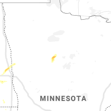
Minnesota
| Local Time | Report Details |
|---|---|
| 5:36 PM CDT | Willmar municipal airpor in kandiyohi county MN, 31 miles ENE of Montevideo, MN |
| 6:00 PM CDT | County deputy had reports of several trees down in willmar. time estimated from rada in kandiyohi county MN, 34.7 miles ENE of Montevideo, MN |
| 9:50 PM CDT | Quarter sized hail reported near Bemidji, MN, 0.5 miles N of Bemidji, MN, along division street |
| 2:44 AM CDT | Storm damage reported in rock county MN, 18.7 miles ENE of Sioux Falls, SD |
Wisconsin
| Local Time | Report Details |
|---|---|
| 5:40 PM CDT | Law enforcement reported several trees blown down in the reedsburg/lavalle area. also... possible road washouts in the area. law enforcement currently investigatin in sauk county WI, 44.9 miles NW of Madison, WI |
Texas
| Local Time | Report Details |
|---|---|
| 6:25 PM CDT | Measured by the ttu west texas mesonet in cochran county TX, 51.8 miles W of Lubbock, TX |
| 7:40 PM CDT | Measured by the ttu west texas mesonet in cochran county TX, 45.7 miles WSW of Lubbock, TX |
| 8:10 PM CDT | Measured by the ttu west texas mesonet in yoakum county TX, 75.2 miles WSW of Lubbock, TX |
| 8:17 PM CDT | Quarter sized hail reported near , , 30.5 miles WNW of Amarillo, TX, spotter network report of quarter sized hail approximately 10 miles south of boys ranch along us385. there may have been a few hailstones of 1.25" in diameter. |
| 8:25 PM CDT | Measured by the ttu west texas mesonet in yoakum county TX, 62.1 miles WSW of Lubbock, TX |
| 9:24 PM CDT | Quarter sized hail reported near Seminole, TX, 62.1 miles NNW of Odessa, TX, lots of small hail to the size of pennies... but a few quarters were mixed in. |
| 10:40 PM CDT | Golf Ball sized hail reported near Kermit, TX, 42 miles W of Odessa, TX |
Nebraska
| Local Time | Report Details |
|---|---|
| 7:20 PM CDT | Tree damage sustained with estimated gusts of 55 to 60 mph. limb that was damaged was about 4 to 5 inches in diamete in douglas county NE, 5.3 miles WNW of Omaha, NE |
| 7:30 PM CDT | Report from social media of a tree limb that fell on a house. estimated size from the picture attached is around 4 inches in diamete in douglas county NE, 6 miles WNW of Omaha, NE |
| 6:42 PM MDT | Quarter sized hail reported near Gordon, NE, 70.6 miles W of Valentine, NE, quarter and nickel size hail |
| 6:55 PM MDT | Quarter sized hail reported near Cody, NE, 35.8 miles W of Valentine, NE, pea to quarter size hail |
| 8:15 PM CDT | 1 inch diameter branches down in todd county SD, 18.6 miles NNW of Valentine, NE |
Kansas
| Local Time | Report Details |
|---|---|
| 7:38 PM CDT | Quarter sized hail reported near Hays, KS, 1.8 miles ENE of Hays, KS |
| 7:43 PM CDT | Storm damage reported in ellis county KS, 3.4 miles ESE of Hays, KS |
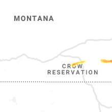
Wyoming
| Local Time | Report Details |
|---|---|
| 6:57 PM MDT | Quarter sized hail reported near Kaycee, WY, 61.4 miles NNW of Casper, WY, multiple reports of hail at least 1 inch with one report of half dollar sized. |
| 7:09 PM MDT | Quarter sized hail reported near Kaycee, WY, 61.4 miles NNW of Casper, WY |
| 7:13 PM MDT | Quarter sized hail reported near Kaycee, WY, 61.2 miles NNW of Casper, WY |
| 7:25 PM MDT | Quarter sized hail reported near Kaycee, WY, 61.2 miles NNW of Casper, WY |
| 7:53 PM MDT | Quarter sized hail reported near Kaycee, WY, 60 miles N of Casper, WY |
| 7:58 PM MDT | Golf Ball sized hail reported near Kaycee, WY, 57.9 miles SW of Gillette, WY |
| 8:11 PM MDT | Golf Ball sized hail reported near Kaycee, WY, 56.6 miles SW of Gillette, WY |
| 8:20 PM MDT | Hen Egg sized hail reported near Gillette, WY, 48.3 miles SSW of Gillette, WY |
Tennessee
| Local Time | Report Details |
|---|---|
| 9:25 PM EDT | Multiple trees down along hwy 11. also some hail but size unknow in loudon county TN, 33.1 miles SW of Knoxville, TN |
| 9:44 PM EDT | Several trees down along hwy 6 in claiborne county TN, 36.9 miles N of Knoxville, TN |
| 11:20 PM EDT | Tree down on hwy 44 in sevier county TN, 23.4 miles ESE of Knoxville, TN |
Connect with Interactive Hail Maps