

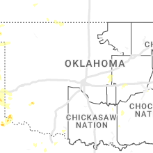
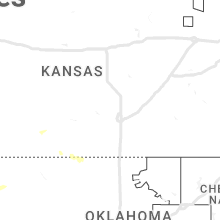
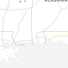
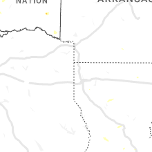
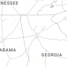
Hail Map for Wednesday, July 5, 2023

Number of Impacted Households on 7/5/2023
0
Impacted by 1" or Larger Hail
0
Impacted by 1.75" or Larger Hail
0
Impacted by 2.5" or Larger Hail
Square Miles of Populated Area Impacted on 7/5/2023
0
Impacted by 1" or Larger Hail
0
Impacted by 1.75" or Larger Hail
0
Impacted by 2.5" or Larger Hail


Cities Most Affected by Hail Storms of 7/5/2023
| Hail Size | Demographics of Zip Codes Affected | ||||||
|---|---|---|---|---|---|---|---|
| City | Count | Average | Largest | Pop Density | House Value | Income | Age |
| Canadian, TX | 2 | 2.13 | 2.50 | 3 | $57k | $35.4k | 35.6 |
| Trinidad, CO | 2 | 1.88 | 2.00 | 20 | $86k | $28.3k | 42.5 |
| Springer, NM | 2 | 1.75 | 1.75 | 0 | $52k | $29.3k | 45.3 |
| Rocky Ford, CO | 1 | 3.00 | 3.00 | 19 | $61k | $29.2k | 43.2 |
| La Junta, CO | 1 | 3.00 | 3.00 | 19 | $69k | $30.5k | 39.2 |
| Solano, NM | 1 | 2.75 | 2.75 | 0 | $0k | $0.0k | 53.8 |
| Monument, CO | 1 | 2.00 | 2.00 | 691 | $270k | $87.9k | 42.8 |
| Roy, NM | 1 | 1.75 | 1.75 | 0 | $24k | $22.5k | 56.3 |
| Wagon Mound, NM | 1 | 1.75 | 1.75 | 0 | $25k | $22.0k | 50.8 |
| Miami, TX | 1 | 1.75 | 1.75 | 1 | $48k | $38.1k | 40.5 |
Hail and Wind Damage Spotted on 7/5/2023
Filter by Report Type:Hail ReportsWind Reports
States Impacted
Wisconsin, Arkansas, North Carolina, Florida, Illinois, Missouri, Texas, Maine, Colorado, Alabama, Kentucky, New Mexico, Mississippi, Georgia, Tennessee, Indiana, Nebraska, Kansas, OklahomaWisconsin
| Local Time | Report Details |
|---|---|
| 12:16 PM CDT | Large tree down in the area of e. rockdale rd in the town of christian in dane county WI, 19.4 miles ESE of Madison, WI |
| 12:19 PM CDT | Power lines reported down in town of rockdal in dane county WI, 19.6 miles ESE of Madison, WI |
| 12:28 PM CDT | Quarter sized hail reported near Madison, WI, 6.8 miles SSW of Madison, WI, quarter size hail now falling within this storm. |
| 12:30 PM CDT | Tree limbs down in fitchburg. via dane county dispatc in dane county WI, 6.1 miles SSW of Madison, WI |
| 12:33 PM CDT | Trees down on the east side of fitchbur in dane county WI, 5 miles S of Madison, WI |
| 12:50 PM CDT | Power lines knocked down east of stoughton. via dane county 91 in dane county WI, 14.2 miles SE of Madison, WI |
| 2:00 PM CDT | Whole tree about 15-20 inches in diameter down across the roa in dane county WI, 15.5 miles SE of Madison, WI |
| 2:00 PM CDT | Corrects previous tstm wnd dmg report from 1 ene milwaukee. multiple reports of downed large limbs... uprooted and snapped trees. time estimated with rada in milwaukee county WI, 75.3 miles E of Madison, WI |
| 2:53 PM CDT | Large tree snapped causing power outage. time estimated with rada in sheboygan county WI, 57.3 miles SSE of Green Bay, WI |
| 3:56 PM CDT | Large limbs down. time estimated with rada in milwaukee county WI, 68.3 miles N of Chicago, IL |
Arkansas
| Local Time | Report Details |
|---|---|
| 1:20 PM CDT | A few trees blown down across mountain hom in baxter county AR, 78.4 miles SE of Springfield, MO |
| 2:30 PM CDT | Several trees blown down south of mt. id in montgomery county AR, 42 miles NNE of Nashville, AR |
| 3:35 PM CDT | Trees down in el dorado at college ave at 8th. damaged a church sign. also 1000 block of crestwood; tree on house. fire department on scene. power cut to hous in union county AR, 53.8 miles NW of Bastrop, LA |
| 4:15 PM CDT | Public reports video of large tree knocked down due to wind. time is radar estimate in clay county AR, 72.7 miles SSW of Cape Girardeau, MO |
| 4:20 PM CDT | Corrects previous tstm wnd dmg report from piggott. public reports video of large tree knocked down due to wind. time is radar estimate in clay county AR, 72.7 miles SSW of Cape Girardeau, MO |
| 4:29 PM CDT | Newport asos measured 62 mph wind gus in jackson county AR, 72.2 miles WNW of Memphis, TN |
| 5:37 PM CDT | Trained spotter reports tree down on power lines on marr l in mississippi county AR, 55 miles N of Memphis, TN |
North Carolina
| Local Time | Report Details |
|---|---|
| 2:30 PM EDT | Several trees reported down in the area of nc hwy 42 s and fairview farm rd in asheboro. time estimated by rada in randolph county NC, 62.3 miles W of Raleigh, NC |
| 2:34 PM EDT | Tree down at old stage rd and pete fish r in wake county NC, 17.2 miles S of Raleigh, NC |
| 4:02 PM EDT | Weather spotter reported trees dow in duplin county NC, 42.9 miles NNW of Wilmington, NC |
| 4:06 PM EDT | Tree fell and damaged roof of house west of rose hill. time estimated from rada in duplin county NC, 41.3 miles N of Wilmington, NC |
| 4:09 PM EDT | Trees down. time estimated from rada in duplin county NC, 53.4 miles N of Wilmington, NC |
| 4:14 PM EDT | Trees down. time estimated from rada in duplin county NC, 34.9 miles N of Wilmington, NC |
| 4:15 PM EDT | Tree down blocking road. time estimated from rada in onslow county NC, 51.6 miles NNE of Wilmington, NC |
| 4:33 PM EDT | Tree fallen on highway 50... blocking the roa in duplin county NC, 42.6 miles N of Wilmington, NC |
Florida
| Local Time | Report Details |
|---|---|
| 2:35 PM EDT | Report passed on from fdem of two planes flipped over at kissimmee gateway airport due to high wind gusts. time estimated via rada in osceola county FL, 17.5 miles SSW of Orlando, FL |
| 3:15 PM CDT | Tree down in de funiak spring in walton county FL, 27.8 miles NNE of Miramar Beach, FL |
| 3:15 PM CDT | A power line and trees have been reported to have fallen down across the road in the area of 940 south 2nd street cross street of bruce avenue and hill stree in walton county FL, 27.5 miles NNE of Miramar Beach, FL |
| 3:16 PM CDT | A reported transformer has fallen and a small fire has been reported near burger king... us hwy 331 in walton county FL, 26.6 miles NNE of Miramar Beach, FL |
| 7:05 PM EDT | Mesonet station xtrm terminal channe in duval county FL, 1.7 miles ENE of Jacksonville, FL |
Illinois
| Local Time | Report Details |
|---|---|
| 1:59 PM CDT | Tree limbs down near highway 20 and elizabeth scales mound road. relayed by law enforcement. time estimated by rada in jo daviess county IL, 68.3 miles SW of Madison, WI |
| 2:24 PM CDT | Large branches downe in cook county IL, 21.4 miles SSW of Chicago, IL |
| 2:42 PM CDT | Photos from twitter report show heavy tree damage in lewistown some trees/branches on house in fulton county IL, 36.2 miles WSW of Peoria, IL |
| 2:54 PM CDT | Multiple tree branches downed in morton grove near frontage road and i-94. relayed via wgn-tv. time estimated by rada in cook county IL, 12.9 miles NNW of Chicago, IL |
| 2:56 PM CDT | Large tree uprooted landing on a buildin in cook county IL, 13.4 miles S of Chicago, IL |
| 3:09 PM CDT | Downed power pole in cook county IL, 26.3 miles S of Chicago, IL |
| 4:25 PM CDT | Estimated 50-60 mp in de kalb county IL, 62.3 miles W of Chicago, IL |
| 5:20 PM CDT | Report of straight-line winds heading southbound on i-57 with trees bending and a couple snapped. size and health of the trees unknow in effingham county IL, 26.4 miles SSW of Mattoon, IL |
| 5:34 PM CDT | Private weather station kilauror58 recorded a 60mph gust near north auror in kane county IL, 33.2 miles W of Chicago, IL |
| 5:47 PM CDT | Numerous trees and powerlines down throughout the cit in kane county IL, 36 miles WSW of Chicago, IL |
| 6:54 PM CDT | Private weather station kilparkf15 recorded a 64 mph wind gust near park fores in will county IL, 29.5 miles S of Chicago, IL |
| 7:05 PM CDT | Large branch down blocking 101st and torrenc in cook county IL, 12.4 miles SSE of Chicago, IL |
| 7:15 PM CDT | 15 inch diameter tree downed near 182nd street and violet road. relayed via amateur radio. time estimated by rada in cook county IL, 22.7 miles S of Chicago, IL |
Missouri
| Local Time | Report Details |
|---|---|
| 3:35 PM CDT | Corrects time previous tstm wnd dmg report from poplar bluff. multiple trees down... reports of power outages and a tree fell on a hous in butler county MO, 60.3 miles SW of Cape Girardeau, MO |
| 4:30 PM CDT | Multiple trees down reports of power outages and a tree fell on a hous in butler county MO, 60.3 miles SW of Cape Girardeau, MO |
Texas
| Local Time | Report Details |
|---|---|
| 3:45 PM CDT | Golf Ball sized hail reported near Canadian, TX, 61.7 miles WSW of Woodward, OK, picture sent via social media. location estimated by radar. |
| 3:47 PM CDT | Measured by west texas mesone in hemphill county TX, 61.1 miles SW of Woodward, OK |
| 4:10 PM CDT | Golf Ball sized hail reported near Miami, TX, 77.2 miles ENE of Amarillo, TX |
| 5:02 PM CDT | Tennis Ball sized hail reported near Canadian, TX, 76.9 miles SW of Woodward, OK, storm chaser reported a few very large hail stones as he traveled south on highway 83. hail appeared to be wrapping around the rear flank down downdraft of a supercell |
| 5:25 PM CDT | Measured by a west texas mesone in hemphill county TX, 78.5 miles SW of Woodward, OK |
| 6:20 PM CDT | Quarter sized hail reported near Mclean, TX, 60.1 miles NNW of Childress, TX |
| 6:26 PM CDT | Quarter sized hail reported near Wheeler, TX, 70 miles N of Childress, TX |
| 7:10 PM CDT | Wind measured by west texas mesonet. several large trees reported down near fm 1547. large branches are blocking fm 314 in collingsworth county TX, 46.1 miles NNW of Childress, TX |
| 7:20 PM CDT | Snapped tree limbs and power pole down along highway 83. chaser reported possible tornad in collingsworth county TX, 49 miles N of Childress, TX |
| 8:59 PM CDT | Storm damage reported in hardeman county TX, 16.7 miles ESE of Childress, TX |
| 9:09 PM CDT | Storm damage reported in hardeman county TX, 16.7 miles ESE of Childress, TX |
| 11:18 PM CDT | Storm damage reported in deaf smith county TX, 46.2 miles ESE of Tucumcari, NM |
| 11:50 PM CDT | Sustained 50 mph. measured by the west texas mesone in parmer county TX, 61.9 miles SW of Amarillo, TX |
| 11:51 PM CDT | Sustained 56 mph. severe wind gusts from 58 to 78 mph from 1150 pm through 1155 pm. measured by the west texas mesone in parmer county TX, 61.9 miles SW of Amarillo, TX |
| 11:56 PM CDT | Tree limb down near midwestern state universit in wichita county TX, 2.9 miles SSW of Wichita Falls, TX |
| 12:37 AM CDT | Corrects previous tstm wnd gst report from 3 se pantex. potential wake low. gusts in excess of 58 mph from 1237 am to 1248 am with peak occurring at 1241 a in carson county TX, 17.8 miles ENE of Amarillo, TX |
| 1:00 AM CDT | Potential wake low. gusts in excess of 58 mph from 1:00am pm to 1:10 am with peak occurring at 1:00 a in potter county TX, 6.5 miles E of Amarillo, TX |
| 1:08 AM CDT | Storm damage reported in lamb county TX, 37.5 miles NNW of Lubbock, TX |
| 1:28 AM CDT | Storm damage reported in hale county TX, 41.4 miles NNE of Lubbock, TX |
| 1:35 AM CDT | Storm damage reported in hale county TX, 39.9 miles N of Lubbock, TX |
| 1:47 AM CDT | Storm damage reported in hale county TX, 40.5 miles NNE of Lubbock, TX |
| 2:04 AM CDT | Storm damage reported in lubbock county TX, 11.6 miles NE of Lubbock, TX |
| 3:12 AM CDT | Storm damage reported in lubbock county TX, 11.6 miles NE of Lubbock, TX |
| 3:15 AM CDT | Storm damage reported in ochiltree county TX, 75.3 miles W of Woodward, OK |
| 4:29 AM CDT | Storm damage reported in gray county TX, 56 miles ENE of Amarillo, TX |
| 4:44 AM CDT | Storm damage reported in hemphill county TX, 77.6 miles SW of Woodward, OK |
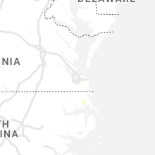
Maine
| Local Time | Report Details |
|---|---|
| 4:50 PM EDT | A couple of trees down in marion township. time estimated via rada in washington county ME, 71.5 miles E of Bangor, ME |
| 5:21 PM EDT | Large tree down on wires blocking the cooper roa in washington county ME, 66.3 miles ENE of Bangor, ME |
| 5:21 PM EDT | Corrects previous tstm wnd dmg report from 2 s alexander. large tree down on wires blocking the cooper road (n. union road) approx 1mi north of route 191. photo via soc in washington county ME, 67.4 miles ENE of Bangor, ME |
Colorado
| Local Time | Report Details |
|---|---|
| 3:19 PM MDT | Golf Ball sized hail reported near Trinidad, CO, 75.6 miles S of Pueblo, CO, report from mping: golf ball (1.75 in.). |
| 3:20 PM MDT | Quarter sized hail reported near Trinidad, CO, 75.1 miles S of Pueblo, CO, report from mping: quarter (1.00 in.). |
| 3:20 PM MDT | Quarter sized hail reported near Trinidad, CO, 75 miles S of Pueblo, CO |
| 3:22 PM MDT | Half Dollar sized hail reported near Trinidad, CO, 75.1 miles S of Pueblo, CO, report from mping: half dollar (1.25 in.). |
| 3:30 PM MDT | Hen Egg sized hail reported near Trinidad, CO, 75.6 miles S of Pueblo, CO, report from mping: hen egg (2.00 in.). |
| 3:42 PM MDT | Hen Egg sized hail reported near Monument, CO, 44.1 miles S of Denver, CO, relayed by broadcast media. |
| 3:45 PM MDT | Quarter sized hail reported near Monument, CO, 46.3 miles S of Denver, CO |
| 5:02 PM MDT | Quarter sized hail reported near Trinidad, CO, 76.3 miles S of Pueblo, CO, report from mping: quarter (1.00 in.). |
| 6:42 PM MDT | Quarter sized hail reported near Colorado Springs, CO, 41 miles NNW of Pueblo, CO |
| 6:48 PM MDT | Quarter sized hail reported near Colorado Springs, CO, 40.7 miles N of Pueblo, CO, report from mping: quarter (1.00 in.). |
| 6:58 PM MDT | Quarter sized hail reported near Colorado Springs, CO, 39.9 miles N of Pueblo, CO, hail of 1.1 inch at 658 pm. |
| 9:05 PM MDT | Quarter sized hail reported near Olney Springs, CO, 37.1 miles E of Pueblo, CO, estimated winds to 50 mph. |
| 9:30 PM MDT | Tea Cup sized hail reported near Rocky Ford, CO, 44.6 miles ESE of Pueblo, CO, piing pong to 3 in hail reported. |
| 9:37 PM MDT | Quarter sized hail reported near Rocky Ford, CO, 49 miles ESE of Pueblo, CO, heavy rain with minor flooding at this time. |
| 9:37 PM MDT | Quarter sized hail reported near Las Animas, CO, 75.9 miles E of Pueblo, CO, winds gusting over 60 mph. 0.85 inches of rain in 15 minutes. hail and rain destroyed garden. |
| 9:42 PM MDT | Asos station klhx la junta airpor in otero county CO, 61.3 miles ESE of Pueblo, CO |
| 9:54 PM MDT | Tea Cup sized hail reported near La Junta, CO, 61.4 miles ESE of Pueblo, CO |
| 10:05 PM MDT | Updates previous tstm wnd dmg report from 1 w las animas. multiple windows on north side of house blown out by wind and hai in bent county CO, 75.9 miles E of Pueblo, CO |
| 11:37 PM MDT | Quarter sized hail reported near Springfield, CO, 106.2 miles WSW of Garden City, KS |
| 11:56 PM MDT | Asos station kspd 8 s springfiel in baca county CO, 107 miles WSW of Garden City, KS |
| 12:02 AM MDT | Sustained 51 kt with gust to 71 k in baca county CO, 106.2 miles WSW of Garden City, KS |
Alabama
| Local Time | Report Details |
|---|---|
| 5:15 PM CDT | Several small and large hardwood branches broken. maxwell afb weather observer noted a peak gust of 37 kts (43 mph in montgomery county AL, 53.6 miles WSW of Auburn, AL |
| 7:18 PM CDT | A few trees were blown down in southside. one social media post shows a home sustained minor roof damag in etowah county AL, 52.9 miles ENE of Birmingham, AL |
Kentucky
| Local Time | Report Details |
|---|---|
| 5:47 PM CDT | Wind damage to several roofs in the are in christian county KY, 61.5 miles NW of Nashville, TN |
| 2:12 AM EDT | Large tree down on lost creek road near thomasville lane in perry county. utility lines are down with it. blocking entire roadway. likely down due to thunderstorms in a in perry county KY, 44.4 miles ESE of Irvine, KY |
New Mexico
| Local Time | Report Details |
|---|---|
| 5:05 PM MDT | Golf Ball sized hail reported near Springer, NM, 54.4 miles E of Taos, NM |
| 5:12 PM MDT | Golf Ball sized hail reported near Springer, NM, 54.5 miles E of Taos, NM, report from mping. |
| 5:13 PM MDT | Quarter sized hail reported near Springer, NM, 54.4 miles E of Taos, NM |
| 5:50 PM MDT | Baseball sized hail reported near Solano, NM, 44.9 miles NNW of Tucumcari, NM, along state route 39. report via twitter. |
| 5:50 PM MDT | Quarter sized hail reported near Roy, NM, 59.4 miles NNW of Tucumcari, NM |
| 6:14 PM MDT | Golf Ball sized hail reported near Wagon Mound, NM, 66 miles NW of Tucumcari, NM, report from mping: golf ball (1.75 in.). |
| 6:15 PM MDT | Golf Ball sized hail reported near Roy, NM, 59.4 miles NNW of Tucumcari, NM, hail started at 550pm and continued through 630pm. largest hail stones were occurring around 615pm. no significant damage noted. |
| 8:27 PM MDT | Mesonet station up364 tucumcari 9 ne (upr in quay county NM, 8.2 miles ENE of Tucumcari, NM |
| 8:31 PM MDT | Asos station ktcc tucumcari muni airpor in quay county NM, 7.1 miles E of Tucumcari, NM |
| 8:35 PM MDT | Asos station ktcc tucumcari muni airpor in quay county NM, 7.1 miles E of Tucumcari, NM |
Mississippi
| Local Time | Report Details |
|---|---|
| 6:20 PM CDT | Report of tree downed across hwy 11 near moselle elementar in jones county MS, 76.9 miles SE of Jackson, MS |
| 7:06 PM CDT | Weakened cedar tree fell across southern oaks drive in clinton. video from social medi in hinds county MS, 9.4 miles NW of Jackson, MS |
| 8:30 PM CDT | Tree downed across hwy 80 from kalem. time estimated based on rada in scott county MS, 34.8 miles E of Jackson, MS |
Georgia
| Local Time | Report Details |
|---|---|
| 7:58 PM EDT | Tree down at stagecoach rd and riverview dr in oglethorp in macon county GA, 85.9 miles ESE of Auburn, AL |
Tennessee
| Local Time | Report Details |
|---|---|
| 7:05 PM CDT | Power lines down on a house on joy lane near airways boulevard. time is radar estimate in shelby county TN, 6.2 miles SE of Memphis, TN |
| 7:11 PM CDT | Corrects previous non-tstm wnd gst report from 4 ne whitehaven. asos station kmem memphi in shelby county TN, 6.7 miles SE of Memphis, TN |
Indiana
| Local Time | Report Details |
|---|---|
| 9:37 PM EDT | Asos station ksbn south bend international a in st. joseph county IN, 69 miles E of Chicago, IL |
| 9:38 PM EDT | Large tree down across road. time estimate in st. joseph county IN, 67.9 miles ESE of Chicago, IL |
| 9:39 PM EDT | Tree down on road. time estimate in st. joseph county IN, 67.6 miles ESE of Chicago, IL |
Nebraska
| Local Time | Report Details |
|---|---|
| 9:17 PM MDT | Half Dollar sized hail reported near Sidney, NE, 64.7 miles NNW of Yuma, CO, half dollar size hail. |
| 9:26 PM MDT | Quarter sized hail reported near Sidney, NE, 65 miles N of Yuma, CO |
Kansas
| Local Time | Report Details |
|---|---|
| 10:20 PM CDT | Quarter sized hail reported near Johnson, KS, 52.9 miles SW of Garden City, KS, report made via social media. |
| 11:38 PM CDT | Quarter sized hail reported near Hugoton, KS, 62.1 miles SSW of Garden City, KS |
Oklahoma
| Local Time | Report Details |
|---|---|
| 1:55 AM CDT | Storm damage reported in cimarron county OK, 108.8 miles NNW of Amarillo, TX |
| 2:00 AM CDT | Quarter sized hail reported near Hooker, OK, 83.7 miles SSW of Garden City, KS, spotter reports quarters in the ama nws chat. |
| 4:25 AM CDT | Storm damage reported in ellis county OK, 38 miles SW of Woodward, OK |
Connect with Interactive Hail Maps