

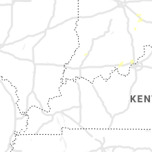
Hail Map for Thursday, July 8, 2021

Number of Impacted Households on 7/8/2021
0
Impacted by 1" or Larger Hail
0
Impacted by 1.75" or Larger Hail
0
Impacted by 2.5" or Larger Hail
Square Miles of Populated Area Impacted on 7/8/2021
0
Impacted by 1" or Larger Hail
0
Impacted by 1.75" or Larger Hail
0
Impacted by 2.5" or Larger Hail


Cities Most Affected by Hail Storms of 7/8/2021
| Hail Size | Demographics of Zip Codes Affected | ||||||
|---|---|---|---|---|---|---|---|
| City | Count | Average | Largest | Pop Density | House Value | Income | Age |
| Newell, SD | 3 | 2.00 | 2.50 | 1 | $38k | $25.9k | 47.2 |
| Faith, SD | 2 | 2.25 | 2.50 | 0 | $41k | $23.9k | 39.4 |
| New Underwood, SD | 2 | 2.13 | 2.50 | 1 | $55k | $34.9k | 41.3 |
| Westwood, NJ | 2 | 1.88 | 2.00 | 2774 | $321k | $82.7k | 43.3 |
| Fairview, MT | 2 | 1.75 | 1.75 | 3 | $41k | $32.1k | 41.3 |
| Amidon, ND | 2 | 1.75 | 1.75 | 1 | $32k | $26.9k | 55.5 |
| Scenic, SD | 1 | 2.75 | 2.75 | 0 | $17k | $31.8k | 48.8 |
| Hillsdale, NJ | 1 | 2.50 | 2.50 | 3522 | $292k | $82.9k | 42.8 |
| Township Of Washington, NJ | 1 | 2.50 | 2.50 | 3172 | $0k | $0.0k | 45.1 |
| Bison, SD | 1 | 2.00 | 2.00 | 0 | $35k | $28.6k | 46.8 |
| Belfield, ND | 1 | 1.75 | 1.75 | 1 | $38k | $28.4k | 45.6 |
| Froid, MT | 1 | 1.75 | 1.75 | 0 | $32k | $26.6k | 52.2 |
Hail and Wind Damage Spotted on 7/8/2021
Filter by Report Type:Hail ReportsWind Reports
States Impacted
Indiana, New Jersey, Virginia, Ohio, Montana, New York, Illinois, Pennsylvania, Michigan, Kentucky, North Dakota, South Dakota, Colorado, Arizona, Georgia, Tennessee, IowaIndiana
| Local Time | Report Details |
|---|---|
| 12:51 PM EDT | Pole barn damaged and an old corn crib destroyed at 5632 west base roa in rush county IN, 33.8 miles ESE of Indianapolis, IN |
| 12:54 PM EDT | Significant roof and side wall damage to house and outbuilding. time estimated by rada in rush county IN, 36 miles ESE of Indianapolis, IN |
| 1:00 PM EDT | Trees damaged and items from yard blown into fields at 2219 s 250 w. time estimated from rada in rush county IN, 37.5 miles ESE of Indianapolis, IN |
| 1:01 PM EDT | Trees down on the north side of rushville. time estimated by rada in rush county IN, 38.7 miles ESE of Indianapolis, IN |
| 1:07 PM EDT | Report from mping: 3-inch tree limbs broken; power poles broke in rush county IN, 38.8 miles ESE of Indianapolis, IN |
| 1:15 PM EDT | Large tree limbs down and crops flattene in rush county IN, 46.7 miles ESE of Indianapolis, IN |
| 1:15 PM EDT | Large tree limb blown dow in rush county IN, 45.7 miles ESE of Indianapolis, IN |
| 1:28 PM EDT | Couple of trees down near us 52 in laurel in franklin county IN, 44.8 miles NW of Cincinnati, OH |
| 3:05 PM CDT | Numerous reports of damage to trees and power lines. power outages reporte in vanderburgh county IN, 1.3 miles E of Evansville, IN |
| 3:09 PM CDT | Report from mping: 3-inch tree limbs broken; power poles broke in vanderburgh county IN, 6.5 miles N of Evansville, IN |
| 3:10 PM CDT | 2 to 3 inch diameter branches dow in vanderburgh county IN, 7.8 miles N of Evansville, IN |
| 4:17 PM EDT | 1-inch tree limbs broken; shingles blown of in grant county IN, 47.2 miles SW of Fort Wayne, IN |
| 5:11 PM EDT | Tree down over chicken run r in jefferson county IN, 55.7 miles NNE of Louisville, KY |
| 7:07 PM EDT | Power lines down at paoli pike and old hill r in floyd county IN, 24.4 miles NNW of Louisville, KY |
| 7:26 PM EDT | Tree down on crums lane in jeffersonvill in clark county IN, 24.3 miles N of Louisville, KY |
| 7:26 PM EDT | Tree down on rolling ridge way in jeffersonvill in clark county IN, 23.6 miles N of Louisville, KY |
| 7:26 PM EDT | Tree down on hamburg pike and bishop rd. in jeffersonvill in clark county IN, 23.6 miles N of Louisville, KY |
| 7:26 PM EDT | Power line down on cedardale dr. in sellersbur in clark county IN, 26.5 miles N of Louisville, KY |
| 7:26 PM EDT | Tree down on power line on w harrison ave in clarksvill in clark county IN, 21 miles N of Louisville, KY |
| 7:26 PM EDT | Tree down over park lane in jeffersonvill in clark county IN, 21.6 miles N of Louisville, KY |
| 7:26 PM EDT | Corrects previous tstm wnd dmg report from 1 wnw clarksville. tree down on gutford rd. in clarksvill in clark county IN, 23.2 miles N of Louisville, KY |
New Jersey
| Local Time | Report Details |
|---|---|
| 1:41 PM EDT | Quarter sized hail reported near Ho Ho Kus, NJ, 22 miles NNW of Brooklyn, NY |
| 1:45 PM EDT | Quarter sized hail reported near Ridgewood, NJ, 20.8 miles NNW of Brooklyn, NY |
| 1:50 PM EDT | Ping Pong Ball sized hail reported near Woodcliff Lake, NJ, 22.8 miles N of Brooklyn, NY |
| 1:50 PM EDT | Large tree dow in bergen county NJ, 22.3 miles NNW of Brooklyn, NY |
| 1:52 PM EDT | Tennis Ball sized hail reported near Township Of Washington, NJ, 21.5 miles N of Brooklyn, NY |
| 1:53 PM EDT | Tennis Ball sized hail reported near Hillsdale, NJ, 22.1 miles N of Brooklyn, NY |
| 1:54 PM EDT | Tree down across grand ave blocking the roa in bergen county NJ, 24.9 miles N of Brooklyn, NY |
| 1:55 PM EDT | Half Dollar sized hail reported near Township Of Washington, NJ, 20.9 miles N of Brooklyn, NY |
| 1:56 PM EDT | Tree down on car at cross section of washington ave and van emburgh av in bergen county NJ, 21.6 miles N of Brooklyn, NY |
| 1:56 PM EDT | Quarter sized hail reported near Westwood, NJ, 20.6 miles N of Brooklyn, NY |
| 2:00 PM EDT | Hen Egg sized hail reported near Westwood, NJ, 20.6 miles N of Brooklyn, NY |
| 2:00 PM EDT | Golf Ball sized hail reported near Westwood, NJ, 20 miles N of Brooklyn, NY, golf ball sized hail in westwood. |
| 2:15 PM EDT | Tree down on power lines and roa in bergen county NJ, 21.1 miles NNW of Brooklyn, NY |
| 2:55 PM EDT | Report and video of strong microburst winds in readington. several trees were uprooted in the area which also brought down power lines. time estimated from radar and an in hunterdon county NJ, 40.3 miles WSW of Brooklyn, NY |
| 2:57 PM EDT | Video shows very strong microburst winds with lawn and patio furniture being blown over and limbs being blown out of trees. several trees were uprooted nearby as a resu in hunterdon county NJ, 41.3 miles W of Brooklyn, NY |
| 3:13 PM EDT | Several trees downed in the area of bedminster and far hills. time estimated from rada in somerset county NJ, 34.7 miles W of Brooklyn, NY |
| 3:15 PM EDT | Trees were downed in peapack. time estimated from rada in somerset county NJ, 35.2 miles W of Brooklyn, NY |
| 3:45 PM EDT | Trees uprooted... power poles down near intersection of route 524 and howell roa in monmouth county NJ, 38.7 miles SSW of Brooklyn, NY |
| 3:45 PM EDT | Snapped trees and overturned patio furniture. pws measured wind gust over 50 mph. time estimated from rada in monmouth county NJ, 35 miles SSW of Brooklyn, NY |
| 3:49 PM EDT | Corrects previous tstm wnd dmg report from 3 ese freehold to the correct time. numerous trees down north of howell. social media video shows a very strong burst of wind in monmouth county NJ, 33.5 miles SSW of Brooklyn, NY |
| 3:51 PM EDT | An mping report of a downed tre in monmouth county NJ, 36 miles SSW of Brooklyn, NY |
| 4:08 PM EDT | A tree was downed on nj-18 northbound ramp to exit 11. time estimated from rada in monmouth county NJ, 30.7 miles S of Brooklyn, NY |
| 4:11 PM EDT | Multiple trees down near middletown township. time estimated from rada in monmouth county NJ, 21.7 miles SSW of Brooklyn, NY |
| 4:13 PM EDT | Tree limbs and wires were downed in red bank. time estimated from rada in monmouth county NJ, 24 miles S of Brooklyn, NY |
| 4:48 PM EDT | Sdhn in monmouth county NJ, 15.4 miles S of Brooklyn, NY |
| 4:49 PM EDT | Numerous trees down north of howell. social media video shows a very strong burst of wind. time estimated from rada in monmouth county NJ, 33.5 miles SSW of Brooklyn, NY |
| 5:50 PM EDT | Trees down on wires... resulting in power outages near chester townshi in morris county NJ, 38.9 miles WNW of Brooklyn, NY |
| 6:13 PM EDT | Downed tree on nj 31 northbound north of nj 57/washington ave (washington twp) all lanes closed. time estimated from rada in warren county NJ, 52.2 miles W of Brooklyn, NY |
| 6:16 PM EDT | Downed tree on us 46 eastbound cr 616/knowlton rd (knowlton twp) all lanes closed. time estimated from rada in warren county NJ, 48.2 miles SE of Scranton, PA |
| 6:28 PM EDT | Power lines and several large branches down at a residence in union twp. time estimated from rada in hunterdon county NJ, 50.5 miles W of Brooklyn, NY |
| 6:30 PM EDT | Trees and wires were downed in holland twp. time estimated from radar and dispatch repor in hunterdon county NJ, 60.2 miles W of Brooklyn, NY |
| 6:55 PM EDT | Tree down on valley station rd in bethlehem twp. time estimated from radar and dispatch repor in hunterdon county NJ, 55.2 miles W of Brooklyn, NY |
| 2:28 AM EDT | Corrects previous non-tstm wnd gst report from 2 nnw sea isle city. ludlam bay - xlud weatherflow sit in anz453 county NJ, 61.9 miles NNE of Ocean City, MD |
| 3:31 AM EDT | Storm damage reported in ocean county NJ, 80.1 miles S of Brooklyn, NY |
| 4:00 AM EDT | Nj11 (njnet in ocean county NJ, 68.2 miles S of Brooklyn, NY |
Virginia
| Local Time | Report Details |
|---|---|
| 2:00 PM EDT | Downed tree limbs and wires in the area of rose hill and ridgevie in fairfax county VA, 43.8 miles SW of Baltimore, MD |
| 2:00 PM EDT | Downed tree limbs and wires in the area of rose hill and ridgevie in fairfax county VA, 43.8 miles SW of Baltimore, MD |
| 2:06 PM EDT | Large tree limbs down near the intersection of duke street and north early street in alexandri in city of alexandria county VA, 42.4 miles SW of Baltimore, MD |
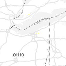
Ohio
| Local Time | Report Details |
|---|---|
| 2:27 PM EDT | Power pole and lines down near intersection of bainbridge and solon roa in cuyahoga county OH, 15.2 miles ESE of Cleveland, OH |
| 2:39 PM EDT | Tree limb down on wire in geauga county OH, 19.1 miles ESE of Cleveland, OH |
| 3:13 PM EDT | Large tree across farmington roa in geauga county OH, 35.5 miles ESE of Cleveland, OH |
| 3:25 PM EDT | Trees and wires down on petrie roa in portage county OH, 44.4 miles SE of Cleveland, OH |
| 3:30 PM EDT | Tree down on wire in trumbull county OH, 42.3 miles ESE of Cleveland, OH |
| 3:58 PM EDT | Large tree limb dow in trumbull county OH, 52.2 miles ESE of Cleveland, OH |
| 3:58 PM EDT | Multiple trees down along fallehn driv in trumbull county OH, 50.9 miles ESE of Cleveland, OH |
Montana
| Local Time | Report Details |
|---|---|
| 12:45 PM MDT | Half Dollar sized hail reported near Malta, MT, 64.5 miles WSW of Glasgow, MT, photo sent in via facebook. size estimated. |
| 1:36 PM MDT | Ping Pong Ball sized hail reported near Scobey, MT, 63.7 miles NE of Glasgow, MT, report from social media. time estimated from radar. |
| 1:40 PM MDT | Quarter sized hail reported near Peerless, MT, 63.7 miles NE of Glasgow, MT, quarter sized hail report on social media. |
| 2:10 PM MDT | Quarter sized hail reported near Saco, MT, 49.7 miles NW of Glasgow, MT, most of the hail is pea size... but there are a few up to the size of quarters. |
| 2:26 PM MDT | Quarter sized hail reported near Saco, MT, 39.2 miles WNW of Glasgow, MT, quarter sized hail report from social media. time estimated from radar. |
| 2:26 PM MDT | Quarter sized hail reported near Saco, MT, 37.9 miles WNW of Glasgow, MT, cooperative observer reports quarter size hail. |
| 2:27 PM MDT | Quarter sized hail reported near Saco, MT, 45.1 miles NW of Glasgow, MT |
| 2:29 PM MDT | Ping Pong Ball sized hail reported near Saco, MT, 37.2 miles WNW of Glasgow, MT, quarter to ping-pong ball sized hail reported on social media. time estimated from radar. |
| 2:30 PM MDT | Quarter sized hail reported near Redstone, MT, 70.8 miles WNW of Williston, ND, mostly pea size hail... but a few were up to the size of quarters. |
| 2:30 PM MDT | Near the cabin area of fort peck. from socail medi in valley county MT, 15.4 miles SE of Glasgow, MT |
| 3:00 PM MDT | Mesonet station mtm34 10.9 n vandalia (mt-meso in valley county MT, 25.1 miles NNW of Glasgow, MT |
| 3:04 PM MDT | Storm damage reported in valley county MT, 5.9 miles N of Glasgow, MT |
| 3:10 PM MDT | Shed was toppled and rolle in valley county MT, 6.3 miles NNE of Glasgow, MT |
| 3:14 PM MDT | Corrects previous tstm wnd gst report from 4 n glasgo in valley county MT, 3.8 miles N of Glasgow, MT |
| 3:14 PM MDT | Ambient weather statio in valley county MT, 1.8 miles NNW of Glasgow, MT |
| 3:29 PM MDT | Reported at fort peck da in mccone county MT, 16.8 miles SE of Glasgow, MT |
| 3:53 PM MDT | Quarter sized hail reported near Froid, MT, 45.1 miles WNW of Williston, ND, quarter sized hail reported on social media. |
| 3:55 PM MDT | Storm damage reported in mccone county MT, 35.1 miles SE of Glasgow, MT |
| 4:04 PM MDT | Trained spotter estimated 70 mph wind gusts... along with pea size hail and plentiful rai in roosevelt county MT, 39.7 miles ENE of Glasgow, MT |
| 4:23 PM MDT | Reported at fort peck da in mccone county MT, 16.8 miles SE of Glasgow, MT |
| 4:25 PM MDT | Asos station kolf wolf point airpor in roosevelt county MT, 49.3 miles E of Glasgow, MT |
| 5:14 PM MDT | Ping Pong Ball sized hail reported near Fairview, MT, 28.5 miles SW of Williston, ND, quarter to ping-pong ball sized hail report on social media. |
| 5:15 PM MDT | Golf Ball sized hail reported near Fairview, MT, 30.6 miles SW of Williston, ND, golf ball sized hail report on social media. |
| 5:15 PM MDT | Ping Pong Ball sized hail reported near Fairview, MT, 28.5 miles SW of Williston, ND, ping pong ball sized hail report from social media. |
| 5:16 PM MDT | Golf Ball sized hail reported near Fairview, MT, 30.1 miles SW of Williston, ND, golf ball sized hail report from social media. |
| 6:27 PM MDT | Mesonet station mtbvr 3.8 ne hodges (mt dot in dawson county MT, 83.7 miles ENE of Miles City, MT |
| 7:23 PM MDT | Golf Ball sized hail reported near Froid, MT, 61.7 miles WNW of Williston, ND, golf ball sized hail report on social media. time estimated from radar. |
New York
| Local Time | Report Details |
|---|---|
| 2:59 PM EDT | Tree down on sprain brook parkwa in westchester county NY, 21.2 miles NNE of Brooklyn, NY |
| 3:44 PM EDT | Tree down near highland ave and tussing lan in erie county NY, 7.9 miles N of Buffalo, NY |
| 3:46 PM EDT | Large tree branch down on leicester r in erie county NY, 5.9 miles N of Buffalo, NY |
| 3:46 PM EDT | Tree down on westchester blv in erie county NY, 6.5 miles N of Buffalo, NY |
| 3:46 PM EDT | Large tree branch down on woodland driv in erie county NY, 7 miles NNE of Buffalo, NY |
| 3:46 PM EDT | Large tree branch on car on treadwell roa in erie county NY, 7.6 miles NNE of Buffalo, NY |
| 3:46 PM EDT | Large tree branch on car on treadwell roa in erie county NY, 7.6 miles NNE of Buffalo, NY |
| 3:52 PM EDT | Very large tree branch dow in niagara county NY, 13.7 miles NNE of Buffalo, NY |
| 3:57 PM EDT | Tree down near sheridan driv in erie county NY, 8.5 miles NE of Buffalo, NY |
| 4:13 PM EDT | Multiple downed tree in erie county NY, 23 miles NE of Buffalo, NY |
| 4:13 PM EDT | Trees down reported by local media in newstea in erie county NY, 20.4 miles ENE of Buffalo, NY |
| 4:18 PM EDT | Trees and wires dow in onondaga county NY, 17.4 miles WNW of Syracuse, NY |
| 4:36 PM EDT | Tree with wires down on lockport rd near elb in genesee county NY, 37.9 miles ENE of Buffalo, NY |
| 5:27 PM EDT | Several trees and wires down reported in the town of hounsfiel in jefferson county NY, 60.2 miles SSW of Ogdensburg, NY |
| 7:33 PM EDT | Multiple reports of trees... a pole and wires down. one on a house... another on a ca in oneida county NY, 43 miles ENE of Syracuse, NY |
| 7:45 PM EDT | Several trees dow in oneida county NY, 53.3 miles ENE of Syracuse, NY |
| 7:45 PM EDT | Trees down on wire in oneida county NY, 51.8 miles ENE of Syracuse, NY |
Illinois
| Local Time | Report Details |
|---|---|
| 2:08 PM CDT | Wires down in white county IL, 34 miles WNW of Evansville, IN |
Pennsylvania
| Local Time | Report Details |
|---|---|
| 3:22 PM EDT | Trees reported dow in lancaster county PA, 56.3 miles NNE of Baltimore, MD |
| 3:30 PM EDT | Trees down on wire in lancaster county PA, 62.6 miles NNE of Baltimore, MD |
| 3:59 PM EDT | Trees down near york spring in adams county PA, 55.7 miles NNW of Baltimore, MD |
| 4:06 PM EDT | Trees were downed in robeson twp. time estimated from rada in berks county PA, 76.4 miles NNE of Baltimore, MD |
| 4:30 PM EDT | A farm equipment storage shed collapse in franklin county PA, 57 miles SSE of State College, PA |
| 4:40 PM EDT | Trees were downed in washington twp. time estimated from rada in berks county PA, 70.5 miles S of Scranton, PA |
| 4:55 PM EDT | Wires down in upper milford twp. time estimated from rada in lehigh county PA, 64.6 miles S of Scranton, PA |
| 4:58 PM EDT | Quarter sized hail reported near Zionsville, PA, 64.7 miles S of Scranton, PA, public report of quarter sized hail south of allentown. time estimated from radar. |
| 5:09 PM EDT | Numerous 911 calls for downed trees in upper saucon. time estimated from rada in lehigh county PA, 61.5 miles SSE of Scranton, PA |
| 5:21 PM EDT | A tree was downed into a house on cedar rd. no injuries but the home is uninhabitable. time estimated from radar and emergency management report in northampton county PA, 60.5 miles SSE of Scranton, PA |
| 5:28 PM EDT | Downed trees blocking hollow rd. time estimated from rada in delaware county PA, 74.9 miles NE of Baltimore, MD |
| 5:35 PM EDT | Tree down on ash rd at airport rd. time estimated from rada in chester county PA, 61.9 miles NE of Baltimore, MD |
| 5:38 PM EDT | Downed tree limbs blocked cedar grove rd. time estimated from rada in montgomery county PA, 82.7 miles SW of Brooklyn, NY |
| 5:40 PM EDT | Tree and wires down on scottdale rd. time estimated from rada in delaware county PA, 83.9 miles ENE of Baltimore, MD |
| 5:43 PM EDT | Tree and wires down on poplar ave. time estimated from rada in delaware county PA, 83.9 miles NE of Baltimore, MD |
| 5:44 PM EDT | Tree and wires down on hilaire rd. time estimated from rada in delaware county PA, 83.9 miles NE of Baltimore, MD |
| 5:45 PM EDT | Wires down on deepdale rd blocking the road. time estimated from rada in chester county PA, 83.1 miles NE of Baltimore, MD |
| 5:46 PM EDT | Tree and wires down on iven ave. time estimated from rada in delaware county PA, 83.9 miles NE of Baltimore, MD |
| 5:47 PM EDT | Downed tree and wires on seaton ross rd at ivywood ln. time estimated from rada in chester county PA, 84.5 miles WSW of Brooklyn, NY |
| 5:47 PM EDT | Tree down blocking wood st at 12th ave. time estimated from rada in montgomery county PA, 80.6 miles WSW of Brooklyn, NY |
| 5:47 PM EDT | Tree down on wires on bernville rd. time estimated from rada in berks county PA, 71.7 miles SSW of Scranton, PA |
| 5:50 PM EDT | Downed tree blocking gawain rd at camelot dr. time estimated from rada in montgomery county PA, 79.1 miles WSW of Brooklyn, NY |
| 5:50 PM EDT | Tree down partially blocking avignon dr at club house rd. time estimated from rada in montgomery county PA, 81.4 miles WSW of Brooklyn, NY |
| 5:56 PM EDT | Tree down on wires blocking jolly rd at beacon hill circle. time estimated from rada in montgomery county PA, 78.8 miles WSW of Brooklyn, NY |
| 6:07 PM EDT | Downed tree blocking e prospect ave at 10th st. time estimated from rada in montgomery county PA, 75.2 miles WSW of Brooklyn, NY |
| 6:10 PM EDT | Large tree branches and wires down in doylestow in bucks county PA, 65.6 miles WSW of Brooklyn, NY |
| 6:12 PM EDT | Video of multiple large trees down on powerlines along almshouse road in doylestown pa. time estimated from rada in bucks county PA, 68.1 miles WSW of Brooklyn, NY |
| 7:30 PM EDT | Tree down blocking the road near county routes 247 and 10 in lackawanna county PA, 14.8 miles NNE of Scranton, PA |
Michigan
| Local Time | Report Details |
|---|---|
| 4:55 PM EDT | Thunderstorm winds damaged power equipment near the intersection of moross rd and beaconsfield st in harper wood in wayne county MI, 55.2 miles SE of Flint, MI |
Kentucky
| Local Time | Report Details |
|---|---|
| 5:45 PM EDT | Tree blew down on ky-36. time estimated from rada in carroll county KY, 48.2 miles SW of Cincinnati, OH |
| 7:28 PM EDT | Tree down over trail ridge road in louisvill in jefferson county KY, 22.8 miles NNE of Louisville, KY |
| 7:26 PM CDT | Report from mping: 1-inch tree limbs broken; shingles blown of in muhlenberg county KY, 48.5 miles SSE of Evansville, IN |
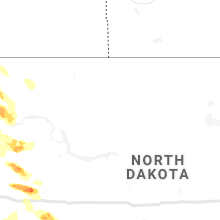
North Dakota
| Local Time | Report Details |
|---|---|
| 4:51 PM CDT | Ndawn station 8n grenora 10 meter wind gus in divide county ND, 42.7 miles NNW of Williston, ND |
| 5:25 PM CDT | Ndawn station 4s hank in williams county ND, 29 miles NNW of Williston, ND |
| 4:52 PM MDT | Half Dollar sized hail reported near Rhame, ND, 105.5 miles S of Williston, ND, relayed from emergency manager. mostly quarters with a few half dollars mixed in. |
| 5:59 PM CDT | Asos station kxwa williston airpor in williams county ND, 9.8 miles NW of Williston, ND |
| 5:59 PM CDT | Ndawn station 5sw williston. gust at 10 meter in williams county ND, 5.6 miles WSW of Williston, ND |
| 5:11 PM MDT | Golf Ball sized hail reported near Amidon, ND, 115.8 miles S of Williston, ND, arb observer. hail lasted about 4 minutes. |
| 5:17 PM MDT | Golf Ball sized hail reported near Amidon, ND, 117.2 miles S of Williston, ND, ongoing at the time of the report. |
| 6:26 PM CDT | Ndawn station 4n ray. measured at 10 meter in williams county ND, 27.2 miles NE of Williston, ND |
| 6:42 PM CDT | Ndawn station hofflun in williams county ND, 23.7 miles E of Williston, ND |
| 7:03 PM CDT | Ndawn station 2e watford cit in mckenzie county ND, 29.5 miles SE of Williston, ND |
| 6:15 PM MDT | Awos station kbww bowman airpor in bowman county ND, 123.1 miles E of Miles City, MT |
| 6:20 PM MDT | Quarter sized hail reported near Reeder, ND, 111.5 miles WSW of Bismarck, ND, report from mping: quarter (1.00 in.). |
| 6:39 PM MDT | Golf Ball sized hail reported near Belfield, ND, 79.6 miles SSE of Williston, ND, golf ball sized hail lasted for about 7 minutes. |
| 8:18 PM MDT | Quarter sized hail reported near Regent, ND, 88.2 miles W of Bismarck, ND, public report of pea... nickel... and quarter size hail. relayed via emergency management. time estimated from radar. |
| 8:26 PM MDT | 60 to 70 mph winds estimated. time estimated from rada in hettinger county ND, 88.4 miles WSW of Bismarck, ND |
| 8:44 PM MDT | 60 mph winds estimated in town. time estimated from rada in hettinger county ND, 79.7 miles WSW of Bismarck, ND |
South Dakota
| Local Time | Report Details |
|---|---|
| 4:23 PM MDT | Golf Ball sized hail reported near Newell, SD, 49.8 miles NNW of Rapid City, SD |
| 4:34 PM MDT | Tennis Ball sized hail reported near Newell, SD, 44.4 miles NNW of Rapid City, SD |
| 4:34 PM MDT | Golf Ball sized hail reported near Newell, SD, 44.5 miles NNW of Rapid City, SD |
| 5:28 PM MDT | Quarter sized hail reported near Sturgis, SD, 20.6 miles NNE of Rapid City, SD |
| 5:44 PM MDT | Golf Ball sized hail reported near New Underwood, SD, 21.3 miles ENE of Rapid City, SD |
| 5:50 PM MDT | Storm damage reported in pennington county SD, 17.5 miles E of Rapid City, SD |
| 5:59 PM MDT | Storm damage reported in pennington county SD, 15.2 miles E of Rapid City, SD |
| 6:00 PM MDT | Tennis Ball sized hail reported near New Underwood, SD, 21.5 miles E of Rapid City, SD |
| 6:30 PM MDT | Baseball sized hail reported near Scenic, SD, 37.7 miles ESE of Rapid City, SD |
| 7:04 PM MDT | Hen Egg sized hail reported near Bison, SD, 107.5 miles NNE of Rapid City, SD |
| 7:13 PM MDT | Quarter sized hail reported near Kyle, SD, 64.5 miles SE of Rapid City, SD |
| 7:26 PM MDT | Ping Pong Ball sized hail reported near Lodgepole, SD, 117.2 miles N of Rapid City, SD |
| 7:55 PM MDT | Ping Pong Ball sized hail reported near Martin, SD, 68.9 miles WNW of Valentine, NE, mostly small hail...but a few ping pong balls |
| 8:24 PM MDT | Hen Egg sized hail reported near Faith, SD, 92.6 miles NNE of Rapid City, SD |
| 8:40 PM MDT | Quarter sized hail reported near Dupree, SD, 77.5 miles NW of Pierre, SD |
| 9:07 PM MDT | Tennis Ball sized hail reported near Faith, SD, 79.3 miles NE of Rapid City, SD |
| 10:55 PM CDT | Quarter sized hail reported near Parkston, SD, 64.9 miles WSW of Sioux Falls, SD, social media report of quarter size hail along with 0.25 inches of rain. |
| 11:25 PM CDT | Ping Pong Ball sized hail reported near Freeman, SD, 37.6 miles WSW of Sioux Falls, SD, social media report of ping pong sized hail. |
| 11:29 PM CDT | Half Dollar sized hail reported near Freeman, SD, 35.4 miles WSW of Sioux Falls, SD, lots of half dollar sized hail stripped the corn along 280th street very badly. |
| 11:29 PM CDT | Half Dollar sized hail reported near Freeman, SD, 37.7 miles WSW of Sioux Falls, SD, heavy rain and hail up to size of half dollars. |
| 2:21 AM CDT | Quarter sized hail reported near Sioux Falls, SD, 5.3 miles WSW of Sioux Falls, SD, mostly dime/nickel sized hail... a few quarters. |
Colorado
| Local Time | Report Details |
|---|---|
| 5:52 PM MDT | Kako aso in washington county CO, 26 miles W of Yuma, CO |
Arizona
| Local Time | Report Details |
|---|---|
| 5:15 PM MST | Public report of 0.5 inch hail... torrential rainfall... and wind damage due to thunderstorm. wind damage included snapped flag pole... pushed bbq off deck... and multi in yavapai county AZ, 63.8 miles SSW of Flagstaff, AZ |
Georgia
| Local Time | Report Details |
|---|---|
| 8:41 PM EDT | A tree was reported down on a house at the end of new horizon d in walton county GA, 30.6 miles E of Atlanta, GA |
Tennessee
| Local Time | Report Details |
|---|---|
| 11:05 PM CDT | Powerlines down along the 300 block of ashport roa in madison county TN, 36.6 miles SW of Mc Kenzie, TN |
Iowa
| Local Time | Report Details |
|---|---|
| 12:29 AM CDT | Quarter sized hail reported near Le Mars, IA, 49.1 miles W of Storm Lake, IA, quarter sized hail and heavy rain. |
| 12:31 AM CDT | Quarter sized hail reported near Le Mars, IA, 49.1 miles W of Storm Lake, IA, quarter sized hail... heavy rain... and not much wind. |
| 2:17 AM CDT | Quarter sized hail reported near Hawarden, IA, 36.4 miles SSE of Sioux Falls, SD |
| 2:23 AM CDT | Quarter sized hail reported near Woodbine, IA, 31.6 miles NNE of Omaha, NE |
Connect with Interactive Hail Maps