

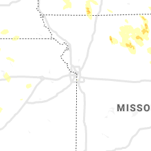
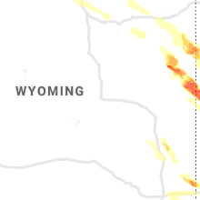
Hail Map for Friday, July 9, 2021

Number of Impacted Households on 7/9/2021
0
Impacted by 1" or Larger Hail
0
Impacted by 1.75" or Larger Hail
0
Impacted by 2.5" or Larger Hail
Square Miles of Populated Area Impacted on 7/9/2021
0
Impacted by 1" or Larger Hail
0
Impacted by 1.75" or Larger Hail
0
Impacted by 2.5" or Larger Hail


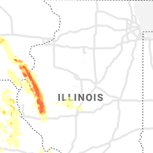


Cities Most Affected by Hail Storms of 7/9/2021
| Hail Size | Demographics of Zip Codes Affected | ||||||
|---|---|---|---|---|---|---|---|
| City | Count | Average | Largest | Pop Density | House Value | Income | Age |
| Alliance, NE | 4 | 3.25 | 4.25 | 10 | $73k | $39.4k | 40.8 |
| Woodward, IA | 5 | 2.40 | 3.00 | 20 | $85k | $43.5k | 40.4 |
| Johnston, IA | 5 | 2.00 | 2.75 | 861 | $190k | $76.3k | 36.8 |
| Des Moines, IA | 4 | 2.13 | 3.25 | 3702 | $76k | $35.5k | 32.6 |
| Hemingford, NE | 4 | 2.06 | 2.50 | 1 | $56k | $34.0k | 45.7 |
| Urbandale, IA | 4 | 2.06 | 2.75 | 2954 | $127k | $57.3k | 39.4 |
| Saint Louis, MO | 3 | 1.83 | 2.00 | 1905 | $194k | $62.6k | 42.1 |
| Ogden, IA | 3 | 1.75 | 1.75 | 15 | $80k | $40.2k | 43.5 |
| Burlington, IA | 2 | 2.13 | 2.50 | 260 | $67k | $35.1k | 40.9 |
| Plymouth, IL | 2 | 2.13 | 2.50 | 10 | $25k | $33.6k | 39.9 |
| Angora, NE | 1 | 2.50 | 2.50 | 1 | $48k | $28.9k | 49.8 |
| Maryland Heights, MO | 1 | 2.00 | 2.00 | 1574 | $107k | $52.0k | 38.2 |
| Ellis Grove, IL | 1 | 1.75 | 1.75 | 26 | $56k | $41.0k | 42.4 |
| Greenfield, IA | 1 | 1.75 | 1.75 | 23 | $63k | $36.9k | 46.0 |
| Ankeny, IA | 1 | 1.75 | 1.75 | 1337 | $0k | $0.0k | 31.7 |
| Grimes, IA | 1 | 1.75 | 1.75 | 359 | $123k | $57.9k | 31.6 |
| Kimball, NE | 1 | 1.75 | 1.75 | 7 | $54k | $30.6k | 45.6 |
| Perry, IA | 1 | 1.75 | 1.75 | 89 | $73k | $36.6k | 35.3 |
| Willow Springs, MO | 1 | 1.75 | 1.75 | 24 | $52k | $22.5k | 40.8 |
| Mount Sterling, IL | 1 | 1.75 | 1.75 | 20 | $50k | $34.0k | 35.8 |
| Mount Pleasant, IA | 1 | 1.75 | 1.75 | 54 | $85k | $38.4k | 39.1 |
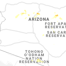
| Rimrock, AZ | 1 | 1.75 | 1.75 | 13 | $105k | $35.0k | 44.9 |
| Lusk, WY | 1 | 1.75 | 1.75 | 0 | $63k | $30.4k | 44.7 |
| Bridgeton, MO | 1 | 1.75 | 1.75 | 686 | $115k | $49.0k | 45.8 |
| Harrison, NE | 1 | 1.75 | 1.75 | 0 | $37k | $28.2k | 49.9 |
Hail and Wind Damage Spotted on 7/9/2021
Filter by Report Type:Hail ReportsWind Reports
States Impacted
New York, Iowa, Missouri, Colorado, North Carolina, Georgia, Arkansas, Alabama, Pennsylvania, Wyoming, Maryland, Nebraska, Florida, Delaware, Arizona, New Jersey, South Carolina, South Dakota, Illinois, KansasNew York
| Local Time | Report Details |
|---|---|
| 8:18 AM EDT | Elevation 71 fee in suffolk county NY, 35.7 miles ENE of Brooklyn, NY |
| 2:32 PM EDT | Large tree and wires down on route 96 in tompkins county NY, 51.2 miles SSW of Syracuse, NY |
| 3:20 PM EDT | Tree and wires down on whiting hill roa in broome county NY, 47.5 miles S of Syracuse, NY |
| 3:25 PM EDT | Tree down corner of route 11 and johnson hill roa in broome county NY, 48.9 miles S of Syracuse, NY |
| 3:30 PM EDT | Tree and wires down on hickory street whitney poin in broome county NY, 49.7 miles S of Syracuse, NY |
| 3:50 PM EDT | Thunderstorm winds knocked tree down blocking shaw place (roadway in broome county NY, 53.5 miles NNW of Scranton, PA |
| 3:57 PM EDT | Thunderstorm winds knocked tree and wires dow in broome county NY, 53 miles NNW of Scranton, PA |
| 4:03 PM EDT | Wires down across costely r in broome county NY, 47.5 miles NNW of Scranton, PA |
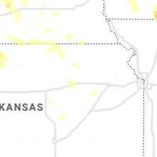
Iowa
| Local Time | Report Details |
|---|---|
| 8:15 AM CDT | Golf Ball sized hail reported near Greenfield, IA, 53.6 miles WSW of Des Moines, IA, largest stones were golfball sized... mostly quarter sized stones. ground white. no wind. |
| 8:33 AM CDT | Quarter sized hail reported near Greenfield, IA, 47.8 miles WSW of Des Moines, IA, delayed report. |
| 11:30 AM CDT | Coop observer reported an estimated wind gust of 60 mph and nickle sized hai in harrison county IA, 39.7 miles N of Omaha, NE |
| 12:43 PM CDT | Quarter sized hail reported near Paton, IA, 47.5 miles NNW of Des Moines, IA, report from mping. |
| 12:50 PM CDT | Quarter sized hail reported near Ogden, IA, 44.7 miles NNW of Des Moines, IA |
| 1:02 PM CDT | Golf Ball sized hail reported near Ogden, IA, 37.7 miles NW of Des Moines, IA, corrects previous hail report from ogden. |
| 1:05 PM CDT | Golf Ball sized hail reported near Ogden, IA, 37.7 miles NW of Des Moines, IA, lasted about 2 min. |
| 1:14 PM CDT | Golf Ball sized hail reported near Ogden, IA, 32.3 miles NW of Des Moines, IA |
| 1:21 PM CDT | Golf Ball sized hail reported near Perry, IA, 33.4 miles NW of Des Moines, IA |
| 1:23 PM CDT | Quarter sized hail reported near Madrid, IA, 29.3 miles NNW of Des Moines, IA |
| 1:27 PM CDT | Golf Ball sized hail reported near Woodward, IA, 26.3 miles NW of Des Moines, IA |
| 1:28 PM CDT | Baseball sized hail reported near Woodward, IA, 23.9 miles NW of Des Moines, IA |
| 1:29 PM CDT | Tea Cup sized hail reported near Woodward, IA, 24.4 miles NW of Des Moines, IA, report via social media. |
| 1:29 PM CDT | Baseball sized hail reported near Woodward, IA, 24.6 miles NW of Des Moines, IA, time estimated. |
| 1:38 PM CDT | Golf Ball sized hail reported near Woodward, IA, 21.5 miles NW of Des Moines, IA |
| 1:55 PM CDT | Golf Ball sized hail reported near Grimes, IA, 11.8 miles NW of Des Moines, IA, report from mping: golf ball (1.75 in.). |
| 1:56 PM CDT | Golf Ball sized hail reported near Johnston, IA, 8.8 miles NNW of Des Moines, IA, report from mping: golf ball (1.75 in.). |
| 1:58 PM CDT | Quarter sized hail reported near Johnston, IA, 8.8 miles NW of Des Moines, IA, report from mping: quarter (1.00 in.). |
| 1:59 PM CDT | Golf Ball sized hail reported near Johnston, IA, 9.7 miles NW of Des Moines, IA |
| 2:00 PM CDT | Golf Ball sized hail reported near Johnston, IA, 7.6 miles NW of Des Moines, IA |
| 2:01 PM CDT | Half Dollar sized hail reported near Urbandale, IA, 6 miles NW of Des Moines, IA, report from mping: half dollar (1.25 in.). |
| 2:01 PM CDT | Ping Pong Ball sized hail reported near Johnston, IA, 8.8 miles NW of Des Moines, IA, report from mping: ping pong ball (1.50 in.). |
| 2:01 PM CDT | Ping Pong Ball sized hail reported near Granger, IA, 14.9 miles NW of Des Moines, IA, report from mping: ping pong ball (1.50 in.). |
| 2:01 PM CDT | Hen Egg sized hail reported near Urbandale, IA, 6.4 miles NW of Des Moines, IA |
| 2:01 PM CDT | Hen Egg sized hail reported near Johnston, IA, 11.7 miles NNW of Des Moines, IA, golf ball to egg size at the nws office in johnston. |
| 2:01 PM CDT | Baseball sized hail reported near Urbandale, IA, 6.1 miles WNW of Des Moines, IA, report from mping: baseball (2.75 in.). |
| 2:02 PM CDT | Quarter sized hail reported near Des Moines, IA, 4.3 miles NW of Des Moines, IA, report from mping: quarter (1.00 in.). |
| 2:02 PM CDT | Quarter sized hail reported near Urbandale, IA, 9.7 miles WNW of Des Moines, IA, report from mping: quarter (1.00 in.). |
| 2:03 PM CDT | Baseball sized hail reported near Johnston, IA, 8.6 miles NW of Des Moines, IA, courtesy whotv. |
| 2:04 PM CDT | 3 inch diameter tree limb snapped. time estimated from rada in boone county IA, 37.7 miles NW of Des Moines, IA |
| 2:05 PM CDT | Golf Ball sized hail reported near Urbandale, IA, 5.3 miles WNW of Des Moines, IA |
| 2:06 PM CDT | Golf Ball sized hail reported near Des Moines, IA, 4.4 miles W of Des Moines, IA, largest hail was golf ball sized around 206pm. |
| 2:08 PM CDT | Golf Ball sized hail reported near Ankeny, IA, 9.8 miles N of Des Moines, IA, half dollar to golf ball sized hail. |
| 2:11 PM CDT | Golf Ball sized hail reported near Urbandale, IA, 6.1 miles WNW of Des Moines, IA |
| 2:14 PM CDT | Ping Pong Ball sized hail reported near Des Moines, IA, 3.6 miles NW of Des Moines, IA, three-quarters to as large as ping pong sized hail. |
| 2:15 PM CDT | Ping Pong Ball sized hail reported near Des Moines, IA, 2.3 miles W of Des Moines, IA, most hail was between dime and nickel size at 31st and ingersoll avenue... but largest estimated was 1.5 inches. hail at time of report. |
| 2:15 PM CDT | Tea Cup sized hail reported near Des Moines, IA, 3.5 miles NW of Des Moines, IA, picture via social media of 3.25 inch hail in beaverdale. time estimated via radar. |
| 2:16 PM CDT | Half Dollar sized hail reported near Des Moines, IA, 0.8 miles E of Des Moines, IA, at the state capitol. |
| 2:21 PM CDT | Golf Ball sized hail reported near Des Moines, IA, 0.8 miles E of Des Moines, IA, increased hail size at the state capitol. |
| 2:23 PM CDT | Golf Ball sized hail reported near Des Moines, IA, 4.3 miles SSW of Des Moines, IA, ongoing at time of report. |
| 2:24 PM CDT | Quarter sized hail reported near Des Moines, IA, 0.3 miles E of Des Moines, IA, at the capital complex. |
| 2:36 PM CDT | Quarter sized hail reported near Carlisle, IA, 9 miles SE of Des Moines, IA, hail ongoing at time of report. |
| 2:49 PM CDT | Ping Pong Ball sized hail reported near Indianola, IA, 17.3 miles SSE of Des Moines, IA, at pickard park east of indianola. |
| 6:13 PM CDT | Golf Ball sized hail reported near Mount Pleasant, IA, 47.8 miles NNE of Kahoka, MO, golf ball hail on 218 near swedesburg. heavy rain with near zero visibility. |
| 6:31 PM CDT | Ping Pong Ball sized hail reported near Mount Union, IA, 47.4 miles NNE of Kahoka, MO |
| 6:51 PM CDT | Quarter sized hail reported near New London, IA, 38.5 miles NNE of Kahoka, MO, dime to quarter sized hail. |
| 7:19 PM CDT | Quarter sized hail reported near West Burlington, IA, 40.3 miles NE of Kahoka, MO |
| 7:20 PM CDT | Ping Pong Ball sized hail reported near Burlington, IA, 35.1 miles NE of Kahoka, MO |
| 7:22 PM CDT | Golf Ball sized hail reported near Burlington, IA, 40.2 miles NE of Kahoka, MO |
| 7:24 PM CDT | Ping Pong Ball sized hail reported near Burlington, IA, 41 miles NE of Kahoka, MO |
| 7:28 PM CDT | Tennis Ball sized hail reported near Burlington, IA, 40.1 miles NE of Kahoka, MO, report from mping: tennis ball (2.50 in.). |
| 8:54 PM CDT | Quarter sized hail reported near Donnellson, IA, 17.3 miles NNE of Kahoka, MO |
| 9:00 PM CDT | Tree down near 16th st and timea s in lee county IA, 16.9 miles E of Kahoka, MO |
| 9:18 PM CDT | Corrects previous tstm wnd dmg report from 1 se keokuk. tree down near 16th st and timea st. several 6 to 10 inch diameter branches down in tow in lee county IA, 16.9 miles E of Kahoka, MO |
| 10:24 PM CDT | Ping Pong Ball sized hail reported near Mount Ayr, IA, 69.1 miles SSW of Des Moines, IA |
| 12:06 AM CDT | Iowa mesonet sit in pottawattamie county IA, 39.8 miles E of Omaha, NE |
| 12:33 AM CDT | Storm damage reported in pottawattamie county IA, 5.8 miles E of Omaha, NE |
| 12:35 AM CDT | Storm damage reported in pottawattamie county IA, 7.9 miles E of Omaha, NE |
| 1:40 AM CDT | Rwis site rbfi4 near bedfor in taylor county IA, 75.8 miles ESE of Omaha, NE |
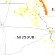
Missouri
| Local Time | Report Details |
|---|---|
| 10:36 AM CDT | Tree down over rt kk just west of hwy 19. time estimated by rada in audrain county MO, 41.3 miles ENE of Columbia, MO |
| 10:36 AM CDT | Tree down across rt b at fifth street. time estimated by rada in audrain county MO, 37 miles ENE of Columbia, MO |
| 11:45 AM CDT | Tree has fallen into a house along hwy in lincoln county MO, 48 miles WNW of Saint Louis, MO |
| 4:02 PM CDT | One tree down on y highway near doniphan. pea to nickle size hail last around 5 minutes. minor street flooding in doniphan. highest reported wind gust 35 mp in ripley county MO, 79.6 miles SSE of Salem, MO |
| 5:20 PM CDT | Numerous large tree limbs down in dudley at 5:20 pm cdt... reported by trained spotte in stoddard county MO, 45.9 miles SW of Cape Girardeau, MO |
| 7:29 PM CDT | Golf Ball sized hail reported near Willow Springs, MO, 50.6 miles SSW of Salem, MO, hail from quarter to golf balls in size were reported. |
| 8:45 PM CDT | Quarter sized hail reported near Maywood, MO, 33.1 miles S of Kahoka, MO |
| 9:18 PM CDT | Half Dollar sized hail reported near Bridgeton, MO, 15.5 miles WNW of Saint Louis, MO, report near i-70 and i-270 interchange. |
| 9:20 PM CDT | Quarter sized hail reported near Bridgeton, MO, 15.9 miles NW of Saint Louis, MO |
| 9:21 PM CDT | Quarter sized hail reported near Saint Ann, MO, 12.5 miles NW of Saint Louis, MO |
| 9:21 PM CDT | Quarter sized hail reported near Saint Louis, MO, 10.5 miles WNW of Saint Louis, MO |
| 9:22 PM CDT | Hen Egg sized hail reported near Maryland Heights, MO, 14.7 miles WNW of Saint Louis, MO, facebook picture of 2 inch hail. |
| 9:23 PM CDT | Golf Ball sized hail reported near Bridgeton, MO, 14.7 miles WNW of Saint Louis, MO, reported near parkwood and st. charles rock road. |
| 9:27 PM CDT | Ham operator relayed a report of 60 mph wind (estimated) near dorsett and 27 in st. louis county MO, 14.5 miles WNW of Saint Louis, MO |
| 9:31 PM CDT | Half Dollar sized hail reported near Saint Louis, MO, 12.7 miles WNW of Saint Louis, MO, report from mping: half dollar (1.25 in.). |
| 9:32 PM CDT | Ping Pong Ball sized hail reported near Saint Louis, MO, 13.3 miles WNW of Saint Louis, MO, report from mping: ping pong ball (1.50 in.). |
| 9:32 PM CDT | Golf Ball sized hail reported near Saint Louis, MO, 13 miles WNW of Saint Louis, MO, report from mping: golf ball (1.75 in.). |
| 9:32 PM CDT | Hen Egg sized hail reported near Saint Louis, MO, 13 miles WNW of Saint Louis, MO, report taken between schulte road and craig road. |
| 9:42 PM CDT | Quarter sized hail reported near Saint Louis, MO, 12.3 miles WNW of Saint Louis, MO |
| 9:45 PM CDT | Golf Ball sized hail reported near Saint Louis, MO, 12.7 miles W of Saint Louis, MO, at mosley and ladue. |
| 9:47 PM CDT | Quarter sized hail reported near Saint Louis, MO, 8.7 miles W of Saint Louis, MO |
| 10:01 PM CDT | Powerlines down along hwy w in standing water. report relayed courtesy of wgem-t in monroe county MO, 53.9 miles S of Kahoka, MO |
| 10:13 PM CDT | Thunderstorm winds blew trees down near mark twain lake jellystone park. trained spotter estimated wind speeds of 60-70 mp in ralls county MO, 55.4 miles NE of Columbia, MO |
| 10:15 PM CDT | Significant damage to the black jack marina at mark twain lake. time estimated by rada in ralls county MO, 52.8 miles NE of Columbia, MO |
| 10:20 PM CDT | Additional reports of downed power lines... structural damage and parts of roof damage along main street. report relayed by abc 17. time estimated by rada in ralls county MO, 48.6 miles NE of Columbia, MO |
| 11:17 PM CDT | Tree limbs blocking hwy o near rt 111. time estimated by rada in callaway county MO, 28.4 miles ESE of Columbia, MO |
| 11:40 PM CDT | Trees down with winds estimated to be near 60 mp in lincoln county MO, 55.5 miles WNW of Saint Louis, MO |
| 11:43 PM CDT | Quarter sized hail reported near O Fallon, MO, 35.5 miles WNW of Saint Louis, MO, report from mping: quarter (1.00 in.). |
| 11:45 PM CDT | Storm spotter reports 60 mph winds and power flashe in warren county MO, 52.7 miles WNW of Saint Louis, MO |
| 11:46 PM CDT | Trees and powerlines dow in lincoln county MO, 48.6 miles WNW of Saint Louis, MO |
| 11:52 PM CDT | Tree topped. small shed moved several fee in warren county MO, 47 miles WNW of Saint Louis, MO |
| 12:00 AM CDT | Large maple tree blown over by wind onto a hom in callaway county MO, 31.3 miles SE of Columbia, MO |
| 12:00 AM CDT | Several utility poles have been snapped in half near highways t and in st. charles county MO, 40.8 miles W of Saint Louis, MO |
| 12:03 AM CDT | Measured gust from a storm spotte in st. charles county MO, 39.5 miles WNW of Saint Louis, MO |
| 12:08 AM CDT | Several utility poles snapped near highway t and highway in st. charles county MO, 40.8 miles W of Saint Louis, MO |
| 12:15 AM CDT | Tree down near lake st. louis blvd and locksley manor driv in st. charles county MO, 32.8 miles WNW of Saint Louis, MO |
| 12:16 AM CDT | Spotter measured 60 mph with instrumentation installed to private residenc in st. charles county MO, 29.8 miles WNW of Saint Louis, MO |
| 12:20 AM CDT | St charles county smartt fiel in st. charles county MO, 24.3 miles NNW of Saint Louis, MO |
| 12:24 AM CDT | Tree and powerlines down in the road near elm street and sonderen stree in st. charles county MO, 29.8 miles WNW of Saint Louis, MO |
| 12:27 AM CDT | Tree down in the roadway near the 1800 block of highway 9 in st. charles county MO, 30.4 miles W of Saint Louis, MO |
| 12:30 AM CDT | Large tree down on dorsett west of lindberg in st. louis county MO, 13.2 miles WNW of Saint Louis, MO |
| 12:30 AM CDT | Steel highway sign blown over at i-64 and boones crossin in st. louis county MO, 21.9 miles W of Saint Louis, MO |
| 12:35 AM CDT | Large trees down along baltimore avenue and ronald drive in st. an in st. louis county MO, 12 miles NW of Saint Louis, MO |
| 12:35 AM CDT | Power lines dow in st. louis county MO, 13.7 miles NW of Saint Louis, MO |
| 12:36 AM CDT | Two separate incidents of trees into structure off highway 100 near gray summi in franklin county MO, 34.9 miles WSW of Saint Louis, MO |
| 12:40 AM CDT | Large tree branches blown down... 2-4 inches in diamete in st. louis county MO, 9.1 miles WNW of Saint Louis, MO |
| 12:42 AM CDT | St. louis lambert international airpor in st. louis county MO, 12.5 miles NW of Saint Louis, MO |
| 12:44 AM CDT | Numerous large tree limbs blown down around the intersection of flora avenue and midland blv in st. louis county MO, 8.3 miles WNW of Saint Louis, MO |
| 12:50 AM CDT | Large trees down northwest of parkdal in jefferson county MO, 20.3 miles WSW of Saint Louis, MO |
| 12:51 AM CDT | Storm damage reported in st. louis city county MO, 3.8 miles NNW of Saint Louis, MO |
| 12:52 AM CDT | The steeple on the centenary united methodist church partially collapsed due to damaging thunderstorm winds near the intersection of pine street and n. 17th stree in st. louis city county MO, 0.2 miles N of Saint Louis, MO |
| 1:21 AM CDT | Storm damage reported in atchison county MO, 62.1 miles SSE of Omaha, NE |
| 1:30 AM CDT | Large tree branches blown dow in washington county MO, 50.8 miles ENE of Salem, MO |
| 2:29 AM CDT | Corrects previous tstm wnd gst report from saint joseph airpor in buchanan county MO, 49.2 miles NNW of Kansas City, MO |
| 2:29 AM CDT | Corrects previous tstm wnd gst report from saint joseph airpor in buchanan county MO, 49.2 miles NNW of Kansas City, MO |
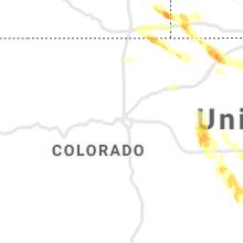
Colorado
| Local Time | Report Details |
|---|---|
| 9:59 AM MDT | Delayed report. measured wind gust of 86 mph in association with a cluster of storms friday evenin in prowers county CO, 84.2 miles W of Garden City, KS |
| 2:51 PM MDT | Quarter sized hail reported near Grover, CO, 73.7 miles SSW of Scottsbluff, NE |
| 4:45 PM MDT | Trained spotted estimated 70 mph wind gust between sterling and ilif in logan county CO, 45.9 miles NNW of Yuma, CO |
| 4:50 PM MDT | Wind damage from fallen tree on powerlines. other report of broken tree limbs falling and damaging a ca in logan county CO, 44.2 miles NW of Yuma, CO |
| 4:52 PM MDT | Corrects previous non-tstm wnd gst report from 2 ese sterling. mesonet station co035 076e125 sterlin in logan county CO, 41.9 miles NW of Yuma, CO |
| 5:00 PM MDT | Power poles knocked down. time estimate in logan county CO, 32.8 miles NNW of Yuma, CO |
| 5:53 PM MDT | Awos station kpub pueblo airpor in pueblo county CO, 6.2 miles E of Pueblo, CO |
| 7:25 PM MDT | Power poles and trees knocked dow in washington county CO, 56.3 miles SW of Yuma, CO |
| 8:55 PM MDT | Report of 71mph wind gust via twitte in cheyenne county CO, 83.4 miles SSW of Yuma, CO |
| 9:20 PM MDT | Estimated winds 40 to 60 mph with blowing dust in kiowa county CO, 93.5 miles SW of Colby, KS |
| 9:57 PM MDT | Klaa 51 kt wind gust in prowers county CO, 99.4 miles W of Garden City, KS |
| 9:59 PM MDT | Storm damage reported in prowers county CO, 79.6 miles W of Garden City, KS |
| 9:59 PM MDT | Corrects previous tstm wnd gst report from 6 wnw granada -- corrected to change 959am to 959pm mdt. measured wind gust of 86 mph in association with a cluster of storms in prowers county CO, 84.2 miles W of Garden City, KS |
| 10:10 PM MDT | Well built outbuilding blown down... multiple power poles down... multiple trees uprooted and snapped... an rv rolled ove in kiowa county CO, 81 miles WNW of Garden City, KS |
| 10:42 PM MDT | Spotter reported 70 plus mph winds... snapping trees and branches in the city par in prowers county CO, 68.3 miles W of Garden City, KS |
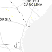
North Carolina
| Local Time | Report Details |
|---|---|
| 1:45 PM EDT | Trees down across roadway on kenwood rd. and pine avenu in gaston county NC, 32 miles WNW of Charlotte, NC |
| 1:59 PM EDT | 911 call center reported trees down on junction r in davie county NC, 45.5 miles NNE of Charlotte, NC |
| 2:05 PM EDT | Trained spotter reported tree fell down onto a hous in lincoln county NC, 20 miles NW of Charlotte, NC |
| 2:15 PM EDT | Trees and powerlines down on north ingleside farm roa in lincoln county NC, 22 miles NNW of Charlotte, NC |
| 2:15 PM EDT | Trees and powerlines down on house on broadleaf d in lincoln county NC, 19.1 miles NW of Charlotte, NC |
| 2:45 PM EDT | Large (5 inch) diameter limbs blown down on a house on dillworth rd. west. took out power to the hous in mecklenburg county NC, 1.7 miles SSW of Charlotte, NC |
| 2:50 PM EDT | Trees and powerlines down at park rd. and east blv in mecklenburg county NC, 1.1 miles SW of Charlotte, NC |
| 4:00 PM EDT | 1 tree down on trollingwood lan in wake county NC, 6.5 miles N of Raleigh, NC |
| 4:30 PM EDT | One tree down on roadway near the intersection of us highway 64 and alex cockman rd. time estimated by rada in chatham county NC, 36 miles W of Raleigh, NC |
| 4:32 PM EDT | One tree down near the intersection of crawford dairy rd and old greensboro rd in chapel hill. time estimated by rada in orange county NC, 34.4 miles WNW of Raleigh, NC |
| 4:33 PM EDT | One tree down on roadway near the intersection of old graham rd and chapel ridge dr. time estimated by rada in chatham county NC, 31.9 miles W of Raleigh, NC |
| 4:50 PM EDT | One tree down near the intersection of lorilane dr and westbrook dr in carrboro. time estimated by rada in orange county NC, 25.8 miles WNW of Raleigh, NC |
| 4:50 PM EDT | Three trees down near the intersection of garrett rd and king charles rd. time estimated by rada in durham county NC, 20.4 miles WNW of Raleigh, NC |
| 4:52 PM EDT | One tree fell on a power line near the intersection of seaforth rd and forest lane. time estimated by rada in chatham county NC, 23.9 miles W of Raleigh, NC |
| 5:40 PM EDT | 2 trees down near falls lake. time estimated by rada in wake county NC, 12.8 miles N of Raleigh, NC |
| 5:40 PM EDT | 3 power poles were snapped near the intersection of oscar loop rd and us highway 301. time estimated by rada in wilson county NC, 34.5 miles ESE of Raleigh, NC |
| 5:40 PM EDT | A tree fell on a mobile home near the intersection of leisure rd and aycocks crossing rd. time estimated by rada in wilson county NC, 35.2 miles ESE of Raleigh, NC |
| 5:45 PM EDT | Trees and power lines down near the intersection of blalock rd and w spring st. time estimated by rada in wilson county NC, 36.4 miles ESE of Raleigh, NC |
| 5:45 PM EDT | One tree down near the intersection of sanders rd and w watson rd. time estimated by rada in johnston county NC, 18.4 miles SSE of Raleigh, NC |
| 6:00 PM EDT | Power outage along ten-ten road due to strong winds gust in wake county NC, 10.2 miles SW of Raleigh, NC |
| 8:08 PM EDT | Tree down at the intersection of bear hole road... and papa bear road in vanceboro. time estimated by rada in craven county NC, 83.7 miles NNE of Wilmington, NC |
| 8:35 PM EDT | Power company reported an outage in maysville caused by fallen trees and/or large limbs on their equipment. time estimated by rada in jones county NC, 61.4 miles NE of Wilmington, NC |
Georgia
| Local Time | Report Details |
|---|---|
| 2:33 PM EDT | A tree was downed at the intersection of nelby drive and allgood roa in dekalb county GA, 10.7 miles ENE of Atlanta, GA |
| 2:45 PM EDT | A tree was blown down onto a power line on wee kirk rd s in dekalb county GA, 5.7 miles SE of Atlanta, GA |
| 3:00 PM EDT | A tree was downed on bethel road n in rockdale county GA, 23.7 miles E of Atlanta, GA |
| 3:04 PM EDT | A tree was downed at the intersection of flat shoals rd se and old salem rd s in rockdale county GA, 23.7 miles ESE of Atlanta, GA |
| 5:09 PM EDT | A tree was downed on old balls ferry road near highway 11 in wilkinson county GA, 79.7 miles SW of Augusta, GA |
| 5:30 PM EDT | A power line was downed along district roa in twiggs county GA, 82.2 miles NNW of Douglas, GA |
Arkansas
| Local Time | Report Details |
|---|---|
| 1:39 PM CDT | Quarter sized hail reported near Floral, AR, 70.9 miles NNE of Little Rock, AR, pea to quarter sized hail was falling. |
Alabama
| Local Time | Report Details |
|---|---|
| 2:25 PM CDT | Large tree down in the rehobeth are in houston county AL, 76 miles NE of Miramar Beach, FL |
| 7:19 PM CDT | Trees down and large branches broken in derby downs neighborhoo in jefferson county AL, 7.7 miles S of Birmingham, AL |
| 7:42 PM CDT | Trees down near rime villag in jefferson county AL, 9.7 miles S of Birmingham, AL |
Pennsylvania
| Local Time | Report Details |
|---|---|
| 3:30 PM EDT | Corrects previous non-tstm wnd dmg report from litchfield. trees and utility wires down in litchfield township. time estimate in bradford county PA, 55.5 miles NW of Scranton, PA |
| 3:57 PM EDT | Trees and wires down on pa-187 in orwell township. time estimate in bradford county PA, 47.2 miles NW of Scranton, PA |
| 4:51 PM EDT | Tree on wires on mount pleasant roa in dauphin county PA, 55.7 miles ESE of State College, PA |
| 4:51 PM EDT | Tree across miller roa in dauphin county PA, 54.9 miles ESE of State College, PA |
| 4:52 PM EDT | Sporadic reports of trees across roads in the valleys of powells creek... clark creek and stony creek from fire and rescue and amateur radi in dauphin county PA, 56.6 miles ESE of State College, PA |
| 5:05 PM EDT | Downed tree blocking entire road on pa-547 in jackson township. time estimate in susquehanna county PA, 29 miles N of Scranton, PA |
| 5:12 PM EDT | Wires down at ford road and pine grove roa in lancaster county PA, 45.3 miles NE of Baltimore, MD |
| 5:24 PM EDT | Trees down across bachmanville road near the pa turnpike and the lawn service plaz in lebanon county PA, 63.5 miles N of Baltimore, MD |
| 5:31 PM EDT | Wires reported down on bossler road near the amtrak mainlin in lancaster county PA, 60 miles N of Baltimore, MD |
| 5:38 PM EDT | Multiple reports of trees on wires across the northern portion of rapho townshi in lancaster county PA, 63.9 miles N of Baltimore, MD |
| 5:49 PM EDT | Tree on a home near hershey drive and east adele av in lancaster county PA, 61.8 miles N of Baltimore, MD |
| 5:53 PM EDT | Tree fell on an occupied vehicle on fruitville pike between lititz road and erbs quarry road. no injurie in lancaster county PA, 59.7 miles NNE of Baltimore, MD |
| 5:56 PM EDT | Trees down on route 772 between lititz and brownstow in lancaster county PA, 62 miles NNE of Baltimore, MD |
| 6:10 PM EDT | Trees and wires dow in luzerne county PA, 33.6 miles WSW of Scranton, PA |
| 6:15 PM EDT | Trees and wires down union townshi in luzerne county PA, 30.2 miles WSW of Scranton, PA |
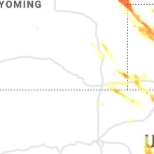
Wyoming
| Local Time | Report Details |
|---|---|
| 2:30 PM MDT | Quarter sized hail reported near Pine Bluffs, WY, 51.6 miles SSW of Scottsbluff, NE |
| 2:37 PM MDT | Quarter sized hail reported near Pine Bluffs, WY, 51.6 miles SSW of Scottsbluff, NE |
| 5:05 PM MDT | Quarter sized hail reported near Sheridan, WY, 73.1 miles WNW of Gillette, WY, dime to quarter sized hail. |
| 5:36 PM MDT | Quarter sized hail reported near Buffalo, WY, 45.5 miles W of Gillette, WY, winds to around 20 mph with quarter-sized hail. |
| 5:49 PM MDT | Quarter sized hail reported near Gillette, WY, 20.1 miles NNW of Gillette, WY |
| 6:15 PM MDT | Storm damage reported in campbell county WY, 9 miles NE of Gillette, WY |
| 6:50 PM MDT | Quarter sized hail reported near Gillette, WY, 30.1 miles SSE of Gillette, WY |
| 6:54 PM MDT | Storm damage reported in weston county WY, 34.7 miles ESE of Gillette, WY |
| 7:30 PM MDT | Storm damage reported in weston county WY, 62.3 miles SE of Gillette, WY |
| 7:30 PM MDT | Storm damage reported in weston county WY, 55.6 miles WSW of Rapid City, SD |
| 7:30 PM MDT | Quarter sized hail reported near Newcastle, WY, 52.3 miles WSW of Rapid City, SD |
| 7:35 PM MDT | Storm damage reported in weston county WY, 56 miles WSW of Rapid City, SD |
| 7:40 PM MDT | Golf Ball sized hail reported near Lusk, WY, 80 miles SE of Gillette, WY |
| 8:06 PM MDT | Ping Pong Ball sized hail reported near Lusk, WY, 86.6 miles SW of Rapid City, SD, county officials reported ping pong ball sized hail and wind gusts around 40 mph. |
Maryland
| Local Time | Report Details |
|---|---|
| 5:10 PM EDT | Downed tree into a fence near the intersection of bishop road and londontown road in edgewate in anne arundel county MD, 24.5 miles S of Baltimore, MD |
| 5:55 PM EDT | Tree and wires down near jacob tome highway and foxfire driv in cecil county MD, 38.5 miles NE of Baltimore, MD |
| 6:00 PM EDT | Holland cliffs road in the area of shady hill farms is closed due to trees and wires down in the roadwa in calvert county MD, 46.3 miles S of Baltimore, MD |
| 6:00 PM EDT | Numerous trees and wires down in the huntingtown area... particuarly along huntingtown road and holland cliffs roa in calvert county MD, 45.6 miles S of Baltimore, MD |
| 6:09 PM EDT | Tree and wires down near the intersection of leeds road and walnut grove roa in cecil county MD, 47 miles ENE of Baltimore, MD |
| 6:18 PM EDT | Tree down blocking all lanes near the intersection of blue ball road and route 27 in cecil county MD, 46.2 miles ENE of Baltimore, MD |
Nebraska
| Local Time | Report Details |
|---|---|
| 3:20 PM MDT | Quarter sized hail reported near Bushnell, NE, 44.4 miles SSW of Scottsbluff, NE |
| 3:29 PM MDT | Golf Ball sized hail reported near Kimball, NE, 44.1 miles S of Scottsbluff, NE, reported at oliver resevoir east of bushnell. estimated time. |
| 4:00 PM MDT | Golf Ball sized hail reported near Harrison, NE, 57.2 miles N of Scottsbluff, NE |
| 4:42 PM MDT | Golf Ball sized hail reported near Hemingford, NE, 37.5 miles NNE of Scottsbluff, NE |
| 4:44 PM MDT | Hen Egg sized hail reported near Hemingford, NE, 41.8 miles NE of Scottsbluff, NE |
| 5:04 PM MDT | Tennis Ball sized hail reported near Hemingford, NE, 41.8 miles NE of Scottsbluff, NE, estimated based on several photos from social media. |
| 5:21 PM MDT | Hen Egg sized hail reported near Hemingford, NE, 35 miles NNE of Scottsbluff, NE |
| 5:34 PM MDT | Ping Pong Ball sized hail reported near Alliance, NE, 44 miles ENE of Scottsbluff, NE, report of near golf ball sized hail in downtown alliance |
| 5:40 PM MDT | Grapefruit sized hail reported near Alliance, NE, 45.2 miles ENE of Scottsbluff, NE, social media report with photo |
| 5:45 PM MDT | Baseball sized hail reported near Alliance, NE, 44 miles ENE of Scottsbluff, NE |
| 5:50 PM MDT | Tea Cup sized hail reported near Alliance, NE, 44 miles ENE of Scottsbluff, NE |
| 6:12 PM MDT | Tea Cup sized hail reported near Alliance, NE, 32.9 miles ENE of Scottsbluff, NE, late report. hail diameter of 3.5 inches southwest of alliance. |
| 6:20 PM MDT | Tennis Ball sized hail reported near Angora, NE, 36.6 miles E of Scottsbluff, NE |
| 8:58 PM CDT | Estimated 70 mph wind gust... with significant blowing dust as storms approach north platt in lincoln county NE, 0.6 miles SW of North Platte, NE |
| 9:00 PM CDT | Significant blowing dust reducing visibilit in lincoln county NE, 1.5 miles WSW of North Platte, NE |
| 9:00 PM CDT | Roof damage in town. picture provided via social media in lincoln county NE, 0.6 miles SW of North Platte, NE |
| 9:04 PM CDT | Storm damage reported in lincoln county NE, 3.8 miles N of North Platte, NE |
| 9:07 PM CDT | Storm damage reported in lincoln county NE, 7.7 miles ESE of North Platte, NE |
| 9:09 PM CDT | 62 knot in lincoln county NE, 0.6 miles SW of North Platte, NE |
| 9:20 PM CDT | Large tree limbs downed... shingles torn off... outdoor furniture displaced in lincoln county NE, 14.5 miles ESE of North Platte, NE |
| 9:26 PM CDT | Davis weatherlink statio in dawson county NE, 32.1 miles ESE of North Platte, NE |
| 9:34 PM CDT | Davis weatherlink statio in dawson county NE, 44.9 miles ESE of North Platte, NE |
| 9:35 PM CDT | Davis weatherlink statio in dawson county NE, 44.9 miles ESE of North Platte, NE |
| 8:38 PM MDT | Storm damage reported in sioux county NE, 70.8 miles NNW of Scottsbluff, NE |
| 8:40 PM MDT | Storm damage reported in sioux county NE, 58.2 miles N of Scottsbluff, NE |
| 9:44 PM CDT | Davis weatherlink statio in dawson county NE, 44.9 miles ESE of North Platte, NE |
| 9:55 PM CDT | Storm damage reported in dawson county NE, 57.2 miles ESE of North Platte, NE |
| 9:58 PM CDT | Davis weatherlink statio in dawson county NE, 63.9 miles W of Grand Island, NE |
| 9:03 PM MDT | Quarter sized hail reported near Chadron, NE, 69.6 miles NNE of Scottsbluff, NE |
| 10:10 PM CDT | Report via twitter of an overturned semi near the elm creek exit. responder reported near zero visibility due to wind and blowing dus in buffalo county NE, 56.9 miles WSW of Grand Island, NE |
| 10:10 PM CDT | Downed tree limbs and power outages in the area. one residence had trailer and roof damage. report of trailers and campers blown over on interstate 80 in the elm creek in buffalo county NE, 56.3 miles WSW of Grand Island, NE |
| 10:11 PM CDT | Up mesonet southeast of overto in dawson county NE, 61.8 miles WSW of Grand Island, NE |
| 10:12 PM CDT | Storm damage reported in buffalo county NE, 19.9 miles W of Grand Island, NE |
| 10:12 PM CDT | Storm damage reported in hall county NE, 19.4 miles W of Grand Island, NE |
| 10:14 PM CDT | Storm damage reported in buffalo county NE, 43.8 miles W of Grand Island, NE |
| 10:16 PM CDT | Storm damage reported in buffalo county NE, 44.5 miles WSW of Grand Island, NE |
| 10:17 PM CDT | Storm damage reported in phelps county NE, 69.1 miles WSW of Grand Island, NE |
| 10:17 PM CDT | Storm damage reported in phelps county NE, 60.1 miles WSW of Grand Island, NE |
| 10:18 PM CDT | Corrects previous non-tstm wnd gst report from edison. on the thunderstorm outflo in furnas county NE, 78.5 miles SE of North Platte, NE |
| 10:21 PM CDT | Report from twitte in buffalo county NE, 50.7 miles WSW of Grand Island, NE |
| 10:22 PM CDT | Est 60mph plus from e in buffalo county NE, 41.3 miles WSW of Grand Island, NE |
| 9:23 PM MDT | Ping Pong Ball sized hail reported near Chadron, NE, 68.6 miles NNE of Scottsbluff, NE, spotter reported broken windows |
| 10:24 PM CDT | Storm damage reported in buffalo county NE, 40.6 miles WSW of Grand Island, NE |
| 10:25 PM CDT | Downed tree limbs and power outages in kearney... several trees snapped off at base. a tree fell onto a home and vehicle... and some damage to siding and fences was rep in buffalo county NE, 42 miles WSW of Grand Island, NE |
| 10:26 PM CDT | Storm damage reported in buffalo county NE, 38.1 miles WSW of Grand Island, NE |
| 9:28 PM MDT | Storm damage reported in dawes county NE, 73.2 miles NNE of Scottsbluff, NE |
| 10:30 PM CDT | Storm damage reported in hall county NE, 3.5 miles NNE of Grand Island, NE |
| 10:30 PM CDT | Part of tree blocking road on 18th and c s in buffalo county NE, 42 miles WSW of Grand Island, NE |
| 10:30 PM CDT | Power out in part of holdrege. power poles snapped. time estimate in phelps county NE, 64.1 miles WSW of Grand Island, NE |
| 10:34 PM CDT | Knewoodr1 in hall county NE, 15.1 miles WSW of Grand Island, NE |
| 10:35 PM CDT | Large tree down on a house. family trapped insid in madison county NE, 50.9 miles SE of Oneill, NE |
| 10:35 PM CDT | Storm damage reported in hall county NE, 10.8 miles S of Grand Island, NE |
| 9:38 PM MDT | Quarter sized hail reported near Hemingford, NE, 39.9 miles NE of Scottsbluff, NE |
| 10:38 PM CDT | Storm damage reported in franklin county NE, 63.7 miles SW of Grand Island, NE |
| 10:38 PM CDT | Storm damage reported in buffalo county NE, 40.4 miles WSW of Grand Island, NE |
| 10:40 PM CDT | Storm damage reported in merrick county NE, 9.8 miles NE of Grand Island, NE |
| 10:41 PM CDT | Storm damage reported in hall county NE, 18.8 miles WSW of Grand Island, NE |
| 10:43 PM CDT | Storm damage reported in hall county NE, 10.7 miles S of Grand Island, NE |
| 10:43 PM CDT | Power outages reported ne part of kearney... twigs to 3-4 inch tree branches down also. 5th and 25th tree branch blocking west bound lane in buffalo county NE, 42.3 miles WSW of Grand Island, NE |
| 10:47 PM CDT | Wind gusts estimated to be near 60 mph... relayed via e in clay county NE, 17.3 miles SSE of Grand Island, NE |
| 10:47 PM CDT | Peak wind off of davis station at the offic in adams county NE, 19.1 miles S of Grand Island, NE |
| 10:49 PM CDT | Em reports trees across the roads in hastings prope in adams county NE, 23.2 miles S of Grand Island, NE |
| 10:50 PM CDT | East side of kearney hwy 30 blocked by fallen tree. power lines down and several transformers blown in town. several fires due to power lines dow in buffalo county NE, 40.3 miles WSW of Grand Island, NE |
| 10:53 PM CDT | Power reported out in the town of phillip in hamilton county NE, 7 miles ESE of Grand Island, NE |
| 10:54 PM CDT | Knerosel in adams county NE, 34.3 miles SSW of Grand Island, NE |
| 10:54 PM CDT | Davis weatherlin in hamilton county NE, 15.6 miles ESE of Grand Island, NE |
| 10:55 PM CDT | Pws-knemeado in pierce county NE, 48.1 miles ESE of Oneill, NE |
| 10:55 PM CDT | Trees down east of pierc in pierce county NE, 62.9 miles ESE of Oneill, NE |
| 10:55 PM CDT | Em relayed report of a large transmission power line downed 4 miles southwest of aurora. wind gusts estimated to be near 80 mph. time based on nearby mesonet repor in hamilton county NE, 15.6 miles ESE of Grand Island, NE |
| 9:56 PM MDT | From cwop sensor northwest of alliance in box butte county NE, 43.3 miles ENE of Scottsbluff, NE |
| 10:56 PM CDT | Storm damage reported in adams county NE, 22.9 miles SSW of Grand Island, NE |
| 10:57 PM CDT | Davis weatherlin in hamilton county NE, 18.2 miles ESE of Grand Island, NE |
| 10:57 PM CDT | Estimate of 60-70 mph wind gust in adams county NE, 32.8 miles S of Grand Island, NE |
| 10:58 PM CDT | Semi blown over at i-80 and giltne in hamilton county NE, 12.3 miles SE of Grand Island, NE |
| 10:58 PM CDT | Semi blown over near at i-80 and aurora exi in hamilton county NE, 14.8 miles ESE of Grand Island, NE |
| 10:59 PM CDT | Law enforcement relayed report of power out in battle cree in madison county NE, 62.4 miles ESE of Oneill, NE |
| 10:59 PM CDT | Law enforcement relayed report of trees and power lines down along highway 27 in madison county NE, 53.1 miles ESE of Oneill, NE |
| 11:00 PM CDT | Storm damage reported in hamilton county NE, 21.1 miles ESE of Grand Island, NE |
| 10:00 PM MDT | Storm damage reported in box butte county NE, 44 miles ENE of Scottsbluff, NE |
| 11:01 PM CDT | Storm damage reported in clay county NE, 23.9 miles SSE of Grand Island, NE |
| 11:01 PM CDT | Report from mping: trees uprooted or snappe in madison county NE, 52.8 miles ESE of Oneill, NE |
| 11:03 PM CDT | Relayed via emergency manage in hamilton county NE, 24.7 miles E of Grand Island, NE |
| 11:04 PM CDT | Peak 2m gust on nebraska mesonet. time estimated from rada in clay county NE, 26.6 miles SSE of Grand Island, NE |
| 11:05 PM CDT | Asos at norfolk airport measured a peak wind gust of 63 mp in madison county NE, 69.9 miles ESE of Oneill, NE |
| 11:05 PM CDT | Est 70mph wind gust in clay county NE, 36.1 miles SE of Grand Island, NE |
| 10:06 PM MDT | Storm chaser south of alliance on highway 385 reported wind driven golf ball sized hail. damaged vehicles. 2 to 3 inch tree limbs on road. storm chaser also reported co in box butte county NE, 41.4 miles ENE of Scottsbluff, NE |
| 10:07 PM MDT | Storm damage reported in box butte county NE, 45.8 miles ENE of Scottsbluff, NE |
| 10:07 PM MDT | Storm damage reported in box butte county NE, 44 miles ENE of Scottsbluff, NE |
| 11:09 PM CDT | Storm damage reported in clay county NE, 34.4 miles SSE of Grand Island, NE |
| 11:10 PM CDT | Storm damage reported in york county NE, 30.8 miles ESE of Grand Island, NE |
| 11:11 PM CDT | Storm damage reported in clay county NE, 34.9 miles SSE of Grand Island, NE |
| 11:14 PM CDT | Reported power outages throughout different areas of rural hamilton count in hamilton county NE, 17.4 miles E of Grand Island, NE |
| 11:15 PM CDT | Em reports many large limbs and trees downed. power and cell coverage out for a large part of the count in clay county NE, 33.2 miles SE of Grand Island, NE |
| 11:17 PM CDT | Storm damage reported in nuckolls county NE, 48.3 miles SSE of Grand Island, NE |
| 11:18 PM CDT | Extensive tree damage down in sutton. power out in all of harvard... some of clay center... some of sutto in clay county NE, 33.2 miles SE of Grand Island, NE |
| 11:20 PM CDT | Tree limbs of 4 to 10 inches in diameter downed in davenport and other parts of thayer count in thayer county NE, 50.7 miles SSE of Grand Island, NE |
| 11:20 PM CDT | Davis weatherlink. time estimated from rada in york county NE, 35.7 miles E of Grand Island, NE |
| 11:21 PM CDT | Storm damage reported in thayer county NE, 52.8 miles SSE of Grand Island, NE |
| 11:24 PM CDT | Report from mping: 1-inch tree limbs broke in stanton county NE, 77.8 miles NW of Omaha, NE |
| 11:25 PM CDT | Estimate of 50-60 mph wind gust in polk county NE, 53.6 miles ENE of Grand Island, NE |
| 11:25 PM CDT | Storm damage reported in thayer county NE, 52.8 miles SSE of Grand Island, NE |
| 11:27 PM CDT | Large branch down blocking roa in madison county NE, 62.7 miles ESE of Oneill, NE |
| 11:28 PM CDT | Davis weatherlin in fillmore county NE, 49.3 miles SE of Grand Island, NE |
| 11:30 PM CDT | Davis weatherlin in fillmore county NE, 52.6 miles SE of Grand Island, NE |
| 11:30 PM CDT | Fire chief est 60mph wind gust in york county NE, 40.8 miles ESE of Grand Island, NE |
| 10:30 PM MDT | Estimated at least 70 mph winds... trees bent over and lost power in sheridan county NE, 72 miles ENE of Scottsbluff, NE |
| 11:30 PM CDT | Storm damage reported in fillmore county NE, 49.3 miles SE of Grand Island, NE |
| 11:31 PM CDT | Storm damage reported in york county NE, 37.8 miles E of Grand Island, NE |
| 11:34 PM CDT | Davis weatherlin in fillmore county NE, 50.8 miles SE of Grand Island, NE |
| 11:34 PM CDT | Tree damage reported in carleton... including a limb 10 inches in diamete in thayer county NE, 55.3 miles SE of Grand Island, NE |
| 10:35 PM MDT | Storm damage reported in garden county NE, 65.2 miles E of Scottsbluff, NE |
| 11:37 PM CDT | Storm damage reported in thayer county NE, 58.4 miles SE of Grand Island, NE |
| 11:37 PM CDT | Law enforcement reported trees down in stanto in stanton county NE, 81.3 miles ESE of Oneill, NE |
| 11:38 PM CDT | Report of 70 mph wind gusts and 1 inch hai in burt county NE, 42.5 miles NNW of Omaha, NE |
| 11:40 PM CDT | Public reported a measured wind gust of 77 mp in colfax county NE, 61.2 miles WNW of Omaha, NE |
| 11:41 PM CDT | Storm damage reported in thayer county NE, 62.2 miles SE of Grand Island, NE |
| 11:42 PM CDT | Asos at tekamah measured a peak wind gust of 59 mp in burt county NE, 36.6 miles NNW of Omaha, NE |
| 11:45 PM CDT | Storm damage reported in thayer county NE, 64.7 miles SE of Grand Island, NE |
| 11:45 PM CDT | Davis weatherlin in fillmore county NE, 51.7 miles ESE of Grand Island, NE |
| 11:45 PM CDT | Est winds 65 to 70mph and could of gusted as high as 80mph. tree limbs down in tow in thayer county NE, 57.5 miles SE of Grand Island, NE |
| 11:45 PM CDT | Knestran in fillmore county NE, 55 miles SE of Grand Island, NE |
| 11:47 PM CDT | Report from mping: 1-inch tree limbs broken; shingles blown of in colfax county NE, 59.8 miles WNW of Omaha, NE |
| 11:50 PM CDT | Lots of tree damage in alexandria... including a tree that fell on top of a car. time estimated from surrounding observation in thayer county NE, 68.3 miles SE of Grand Island, NE |
| 11:51 PM CDT | Several large trees down in henderson... hard to move around town due to trees blocking road in york county NE, 29.5 miles ESE of Grand Island, NE |
| 12:04 AM CDT | Flattened grain bin... flattened cor in madison county NE, 59.3 miles ESE of Oneill, NE |
| 12:08 AM CDT | Storm damage reported in saline county NE, 70 miles ESE of Grand Island, NE |
| 12:11 AM CDT | Personal weather statio in washington county NE, 13.3 miles NW of Omaha, NE |
| 12:11 AM CDT | Report from mping: 1-inch tree limbs broken; shingles blown of in douglas county NE, 5.8 miles WNW of Omaha, NE |
| 12:13 AM CDT | Aso in lancaster county NE, 51.3 miles WSW of Omaha, NE |
| 12:14 AM CDT | Storm damage reported in douglas county NE, 0.1 miles SSE of Omaha, NE |
| 12:15 AM CDT | Storm damage reported in douglas county NE, 15.2 miles WSW of Omaha, NE |
| 12:15 AM CDT | Fremont airport measured a peak wind gust of 74 mp in saunders county NE, 34.4 miles W of Omaha, NE |
| 12:15 AM CDT | Trained spotter estimated wind gusts at 70 mph and reported a power outag in douglas county NE, 5.7 miles W of Omaha, NE |
| 12:22 AM CDT | Report from mping: 1-inch tree limbs broken; shingles blown of in washington county NE, 21.9 miles NNW of Omaha, NE |
| 12:24 AM CDT | Large trees dow in douglas county NE, 15.1 miles W of Omaha, NE |
| 12:25 AM CDT | Trained spotter reported 3 inch tree branch blown off of a healthy tre in sarpy county NE, 10.4 miles S of Omaha, NE |
| 12:26 AM CDT | Storm damage reported in sarpy county NE, 10.8 miles SSW of Omaha, NE |
| 12:26 AM CDT | From social media a small fedex cargo aircraft was blown across tarmac and onto its side along the airport property fence line. time estimated off radar and aso in douglas county NE, 3.8 miles NNE of Omaha, NE |
| 12:27 AM CDT | Report from mping: 3-inch tree limbs broken; power poles broke in sarpy county NE, 9.8 miles S of Omaha, NE |
| 12:30 AM CDT | Report from mping: 3-inch tree limbs broken; power poles broke in douglas county NE, 7.8 miles WSW of Omaha, NE |
| 12:31 AM CDT | Storm damage reported in lancaster county NE, 60 miles SW of Omaha, NE |
| 12:32 AM CDT | Storm damage reported in douglas county NE, 3.8 miles NE of Omaha, NE |
| 12:33 AM CDT | Corrects previous tstm wnd gst report from cedar cree in cass county NE, 16.8 miles SSW of Omaha, NE |
| 12:33 AM CDT | Report from mping: 3-inch tree limbs broken; power poles broke in douglas county NE, 3.5 miles SW of Omaha, NE |
| 11:34 PM MDT | Storm damage reported in hooker county NE, 57.9 miles NW of North Platte, NE |
| 12:36 AM CDT | Report from mping: 3-inch tree limbs broken; power poles broke in sarpy county NE, 8.4 miles S of Omaha, NE |
| 12:39 AM CDT | Report from mping: 3-inch tree limbs broken; power poles broke in sarpy county NE, 11 miles SW of Omaha, NE |
| 12:41 AM CDT | Report from mping: 1-inch tree limbs broken; shingles blown of in pawnee county NE, 72 miles N of Manhattan, KS |
| 12:41 AM CDT | Storm damage reported in cass county NE, 20.3 miles S of Omaha, NE |
| 12:44 AM CDT | 10 inch tree branch dow in saunders county NE, 35.6 miles W of Omaha, NE |
| 12:45 AM CDT | Portion of a roof is tore of in douglas county NE, 13.1 miles W of Omaha, NE |
| 12:45 AM CDT | Numerous trees down in plattsmouth. no powe in cass county NE, 17.5 miles S of Omaha, NE |
| 12:46 AM CDT | Public reported several power poles down... roof blown off a barn... and camper blown over and heavily damage in cass county NE, 31.1 miles S of Omaha, NE |
| 12:48 AM CDT | Report from mping: 3-inch tree limbs broken; power poles broke in sarpy county NE, 10.4 miles S of Omaha, NE |
| 12:48 AM CDT | Grain bins significantly damaged between union and murra in cass county NE, 27 miles S of Omaha, NE |
| 12:50 AM CDT | Storm damage reported in cass county NE, 16.8 miles SSW of Omaha, NE |
| 12:51 AM CDT | Report from mping: 3-inch tree limbs broken; power poles broke in sarpy county NE, 9.7 miles S of Omaha, NE |
| 12:51 AM CDT | Widespread tree damage along with multiple power lines knocked down across hall county this evening. anything south and east of cairo was reported to have storm damag in hall county NE, 1.6 miles WNW of Grand Island, NE |
| 12:52 AM CDT | Report from mping: 3-inch tree limbs broken; power poles broke in douglas county NE, 10.4 miles W of Omaha, NE |
| 1:00 AM CDT | Storm damage reported in johnson county NE, 56.4 miles SSW of Omaha, NE |
| 1:04 AM CDT | Corrects previous non-tstm wnd dmg report from 1 ene fort calhoun. camper overturned... party removed without injuries. trees down in vicinit in washington county NE, 14.8 miles NNW of Omaha, NE |
| 1:14 AM CDT | Report of numerous trees down and power outages across the county. property damage from trees to garages and vehicle in nemaha county NE, 65.1 miles SSE of Omaha, NE |
| 1:38 AM CDT | Falls city airport measured a peak wind gust of 77 mp in richardson county NE, 81 miles NE of Manhattan, KS |
| 2:20 AM CDT | Storm damage reported in lincoln county NE, 3.8 miles E of North Platte, NE |
| 2:30 AM CDT | Sustained at 50 mph gusting to 69 mph on the backside of a thunderstorm comple in lincoln county NE, 2.8 miles E of North Platte, NE |
| 2:43 AM CDT | Storm damage reported in red willow county NE, 60.1 miles NNE of Colby, KS |
Florida
| Local Time | Report Details |
|---|---|
| 5:35 PM EDT | Local media reported a tree had fallen down on a patio roof in holly hill. radar estimated time of this event is 535 p in volusia county FL, 51.8 miles NNE of Orlando, FL |
Delaware
| Local Time | Report Details |
|---|---|
| 6:24 PM EDT | Tree down in the 400 block of lark drive. time estimated from rada in new castle county DE, 51.6 miles ENE of Baltimore, MD |
Arizona
| Local Time | Report Details |
|---|---|
| 3:50 PM MST | Golf Ball sized hail reported near Rimrock, AZ, 38.5 miles S of Flagstaff, AZ, social media reports of lost livestock... chickens... and gardens as well as broken windows and roof damage. included photos of golf ball sized hail. |
| 3:50 PM MST | Social media reports with pictures of blown roof and patio furniture... ac unit ripped off of roof... and broken tree limb in yavapai county AZ, 38.5 miles S of Flagstaff, AZ |
| 4:05 PM MST | Storm damage reported in pima county AZ, 46.2 miles SW of Tucson, AZ |
| 10:10 PM MST | Kiwa metar observatio in maricopa county AZ, 25.9 miles ESE of Phoenix, AZ |
| 10:14 PM MST | Peak gust at srp mesonet station quai in pinal county AZ, 39.3 miles ESE of Phoenix, AZ |
| 10:32 PM MST | Measured by kcgz awo in pinal county AZ, 38.3 miles SSE of Phoenix, AZ |
New Jersey
| Local Time | Report Details |
|---|---|
| 7:45 PM EDT | Law enforcement reports trees down on roadway in washington townshi in gloucester county NJ, 87.4 miles SW of Brooklyn, NY |
| 7:48 PM EDT | Tree down on wires in franklin townshi in gloucester county NJ, 85.6 miles ENE of Baltimore, MD |
South Carolina
| Local Time | Report Details |
|---|---|
| 7:50 PM EDT | Sc highway patrol reported a tree down near the intersection of white hall road and abberly drive. time determined from radar dat in colleton county SC, 49.2 miles NNE of Savannah, GA |
South Dakota
| Local Time | Report Details |
|---|---|
| 5:54 PM MDT | Quarter sized hail reported near Buffalo Gap, SD, 38.8 miles S of Rapid City, SD |
| 7:58 PM MDT | Quarter sized hail reported near Edgemont, SD, 51.1 miles SW of Rapid City, SD |
| 8:11 PM MDT | Storm damage reported in fall river county SD, 66.9 miles SW of Rapid City, SD |
| 8:16 PM MDT | Storm damage reported in fall river county SD, 66.9 miles SW of Rapid City, SD |
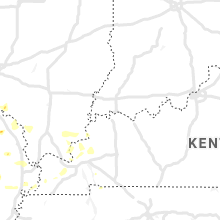
Illinois
| Local Time | Report Details |
|---|---|
| 7:34 PM CDT | Downed tree branche in hancock county IL, 32.6 miles ENE of Kahoka, MO |
| 7:35 PM CDT | Quarter sized hail reported near Dallas City, IL, 33.9 miles ENE of Kahoka, MO |
| 8:06 PM CDT | Quarter sized hail reported near Blandinsville, IL, 44 miles E of Kahoka, MO, mping report. |
| 8:06 PM CDT | Quarter sized hail reported near Blandinsville, IL, 44.2 miles E of Kahoka, MO, report from mping: quarter (1.00 in.). |
| 8:06 PM CDT | Half Dollar sized hail reported near Carthage, IL, 35.6 miles E of Kahoka, MO, lasted over 2 minutes. |
| 8:16 PM CDT | Tennis Ball sized hail reported near Plymouth, IL, 43 miles E of Kahoka, MO, golf ball to tennis ball size hail. |
| 8:20 PM CDT | Branches down...estimated 6 inches in diamete in hancock county IL, 43.2 miles ESE of Kahoka, MO |
| 8:20 PM CDT | Golf Ball sized hail reported near Plymouth, IL, 43.2 miles ESE of Kahoka, MO, quarter to golf ball size hail. |
| 8:23 PM CDT | Quarter sized hail reported near Augusta, IL, 42.7 miles ESE of Kahoka, MO, heavy rain too. |
| 8:48 PM CDT | Golf Ball sized hail reported near Mount Sterling, IL, 59.2 miles ESE of Kahoka, MO, hail fell for about 10 minutes. report relayed by nws davenport. |
| 8:50 PM CDT | Damage to power line and a power pole on the east side of down. social media report. time based on rada in brown county IL, 59.2 miles ESE of Kahoka, MO |
| 9:02 PM CDT | Delayed report of powerlines down over the intersection at hwy 99 and hwy 107 just south of mount sterling. report courtesy of wgem-tv. time estimated by rada in brown county IL, 59.5 miles ESE of Kahoka, MO |
| 11:15 PM CDT | Report of tree down in roadwa in sangamon county IL, 59.6 miles S of Peoria, IL |
| 11:33 PM CDT | Calhoun county sheriff received reports of trees down near michael. time estimated by rada in calhoun county IL, 47.6 miles NNW of Saint Louis, MO |
| 11:35 PM CDT | Corrects previous non-tstm wnd gst report from taylorville airport. awos station ktaz taylorville muni a in christian county IL, 51.1 miles W of Mattoon, IL |
| 12:56 AM CDT | 50-60 mph estimated from a trained spotte in madison county IL, 5.7 miles NNE of Saint Louis, MO |
| 1:02 AM CDT | 66 mph wind gust measured at cahokia airport (kcps in st. clair county IL, 4.5 miles SSE of Saint Louis, MO |
| 1:29 AM CDT | Measured gust at scott air force bas in st. clair county IL, 20.4 miles ESE of Saint Louis, MO |
| 2:06 AM CDT | Golf Ball sized hail reported near Ellis Grove, IL, 45.4 miles SSE of Saint Louis, MO |
Kansas
| Local Time | Report Details |
|---|---|
| 8:10 PM CDT | From ksu mesonet sit in cheyenne county KS, 43.7 miles WNW of Colby, KS |
| 10:10 PM CDT | From ksu mesonet sit in wichita county KS, 44.1 miles NW of Garden City, KS |
| 10:55 PM CDT | From ksu mesonet sit in gove county KS, 47.5 miles SE of Colby, KS |
| 10:13 PM MDT | From outflow winds behind the storm in sherman county KS, 35.1 miles W of Colby, KS |
| 11:20 PM CDT | Mesonet station k5sct 1 ese scott state lak in scott county KS, 49 miles N of Garden City, KS |
| 10:55 PM MDT | Awos station k3k3 syracus in hamilton county KS, 47.9 miles W of Garden City, KS |
| 12:02 AM CDT | Reported at lakin airpor in kearny county KS, 20.6 miles W of Garden City, KS |
| 12:25 AM CDT | Mesonet station ks010 us-50 @ k-156 bridge garden cit in finney county KS, 1.9 miles ENE of Garden City, KS |
| 1:22 AM CDT | Storm damage reported in riley county KS, 13.5 miles NW of Manhattan, KS |
| 1:31 AM CDT | Personal weather station. time estimated from rada in wabaunsee county KS, 21.8 miles E of Manhattan, KS |
| 1:34 AM CDT | Storm damage reported in pottawatomie county KS, 12.8 miles ENE of Manhattan, KS |
| 1:35 AM CDT | Multiple tree branches snapped in the city. in addition... a 40 foot tall tree was snapped and blocking the roadway. health of the tree was unknow in pottawatomie county KS, 14.1 miles E of Manhattan, KS |
| 1:55 AM CDT | 8 inch tree limbs blown dow in shawnee county KS, 42.8 miles ESE of Manhattan, KS |
| 1:56 AM CDT | Storm damage reported in shawnee county KS, 41.9 miles ESE of Manhattan, KS |
| 2:04 AM CDT | Kfoe forbes fiel in shawnee county KS, 50.3 miles ESE of Manhattan, KS |
| 2:35 AM CDT | Storm damage reported in norton county KS, 69.1 miles ENE of Colby, KS |
| 2:41 AM CDT | Sonic restaurant display sign blown out and laying on hwy 36 across all lanes. sign width in road is approximately 15 ft wide by roughly 20 ft across. other smaller par in norton county KS, 68.8 miles ENE of Colby, KS |
| 2:44 AM CDT | Corrects previous non-tstm wnd gst report from 1 e hill city. asos station khlc hill cit in graham county KS, 43.6 miles NW of Hays, KS |
| 2:44 AM CDT | Kkskansa2 in phillips county KS, 55.6 miles N of Hays, KS |
| 2:49 AM CDT | Several tree limbs down. mainly 8 to 10 ft in length and .75 to 1.00 in in diameter snapped from tree. middle of west 100 block of main street in norton. no injuries at in norton county KS, 68.5 miles ENE of Colby, KS |
| 2:55 AM CDT | Awos station koel 2 ese oakle in logan county KS, 23.8 miles SSE of Colby, KS |
| 3:15 AM CDT | Mesonet station up840 9.0 w winona (upr in logan county KS, 33.1 miles SW of Colby, KS |
| 3:16 AM CDT | Asos station khlc hill cit in graham county KS, 43.6 miles NW of Hays, KS |
| 4:38 AM CDT | Kcnk blosser fiel in cloud county KS, 63.4 miles WNW of Manhattan, KS |
Connect with Interactive Hail Maps