

Hail Map for Tuesday, June 12, 2012

Number of Impacted Households on 6/12/2012
0
Impacted by 1" or Larger Hail
0
Impacted by 1.75" or Larger Hail
0
Impacted by 2.5" or Larger Hail
Square Miles of Populated Area Impacted on 6/12/2012
0
Impacted by 1" or Larger Hail
0
Impacted by 1.75" or Larger Hail
0
Impacted by 2.5" or Larger Hail


Cities Most Affected by Hail Storms of 6/12/2012
| Hail Size | Demographics of Zip Codes Affected | ||||||
|---|---|---|---|---|---|---|---|
| City | Count | Average | Largest | Pop Density | House Value | Income | Age |
| Melrose, NM | 4 | 2.44 | 4.50 | 1 | $42k | $30.6k | 45.2 |
| Whiteface, TX | 3 | 2.42 | 2.75 | 0 | $22k | $30.8k | 33.8 |
| Floyd, NM | 2 | 3.50 | 4.50 | 1 | $55k | $30.6k | 45.4 |
| Portales, NM | 2 | 2.25 | 2.75 | 28 | $55k | $26.6k | 29.0 |
| Lovington, NM | 2 | 1.88 | 2.00 | 18 | $49k | $28.5k | 31.1 |
| Dora, NM | 1 | 2.75 | 2.75 | 0 | $60k | $33.1k | 38.5 |
| Springfield, CO | 1 | 2.00 | 2.00 | 3 | $53k | $26.5k | 47.2 |
| Cisco, TX | 1 | 1.75 | 1.75 | 14 | $29k | $26.2k | 41.5 |
| Carlsbad, NM | 1 | 1.75 | 1.75 | 16 | $65k | $32.8k | 38.4 |
| Clovis, NM | 1 | 1.75 | 1.75 | 93 | $66k | $28.9k | 31.3 |
| Sturgis, SD | 1 | 1.75 | 1.75 | 15 | $79k | $34.9k | 44.7 |
Hail and Wind Damage Spotted on 6/12/2012
Filter by Report Type:Hail ReportsWind Reports
States Impacted
Louisiana, Texas, Georgia, Florida, South Carolina, New Mexico, North Carolina, Idaho, Colorado, Pennsylvania, South Dakota, Nebraska, VirginiaLouisiana
| Local Time | Report Details |
|---|---|
| 7:19 AM CDT | Reports of a few trees down on highway 4 near newligh in tensas county LA, 56.5 miles SSE of Bastrop, LA |
Texas
| Local Time | Report Details |
|---|---|
| 12:09 PM CDT | Golf Ball sized hail reported near Cisco, TX, 42.4 miles E of Abilene, TX, quarter to golfball hail began around 1209 pm and still falling |
| 12:38 PM CDT | Sheriff dept reports trees down near kirkland spring off route 28 in tyler county TX, 36.7 miles SSE of Lufkin, TX |
| 1:00 PM CDT | Public reports trees down on powerlines. power out til almost 8 p in tyler county TX, 53.7 miles SSE of Lufkin, TX |
| 1:05 PM CDT | Coop observer reports several trees down in wildwood with diameters between eight and ten inches. observer also reported a tree struck by lightnin in hardin county TX, 51.3 miles NW of Beaumont, TX |
| 1:08 PM CDT | Storm damage reported in eastland county TX, 51.2 miles ESE of Abilene, TX |
| 2:10 PM CDT | Measured at kmkn in comanche county TX, 75.5 miles NW of Killeen, TX |
| 2:15 PM CDT | Powerlines and large tree limbs down throughout town in comanche county TX, 75.4 miles NW of Killeen, TX |
| 2:42 PM CDT | Trees down along fm 1725 and fm 202 in san jacinto county TX, 50.7 miles NNE of Houston, TX |
| 4:05 PM CDT | Numerous large tree limbs blown down. a few large trees blown down as well. estimated 60 mph wind in coryell county TX, 3.9 miles NW of Killeen, TX |
| 4:18 PM CDT | Trees and street signs blown down. traffic lights damaged. newspaper reports some trees blown onto home in montgomery county TX, 39 miles N of Houston, TX |
| 4:37 PM CDT | Trees down across road at forestgate and woodlands pkwy in montgomery county TX, 28.5 miles NNW of Houston, TX |
| 4:40 PM CDT | Large tree limbs down and pea size hail at i-45 rayford/sawdust in montgomery county TX, 28.5 miles NNW of Houston, TX |
| 4:42 PM CDT | Trees blown down just south of the dam in montgomery county TX, 42.8 miles NNW of Houston, TX |
| 4:48 PM CDT | 5-6 inch diameter tree blown down through a brick wall of a residence. location 2 miles west of i-45 near spring stuebner in harris county TX, 20.6 miles N of Houston, TX |
| 4:48 PM CDT | Business sign blown down and onto a car in montgomery county TX, 28.5 miles NNW of Houston, TX |
| 4:54 PM CDT | Street sign damage at richey rd and i-45 in harris county TX, 1.4 miles WNW of Houston, TX |
| 4:54 PM CDT | Trees down through the area. at augusta pines golf in montgomery county TX, 28.5 miles NNW of Houston, TX |
| 4:55 PM CDT | Trees blown down and a few outbuildings damaged near the intersection of sh53 and sh320 in bell county TX, 33.4 miles E of Killeen, TX |
| 5:00 PM CDT | Powerlines and trees blown in milam county TX, 48.6 miles ESE of Killeen, TX |
| 5:07 PM CDT | Trees and powerlines down near rusk in cherokee county TX, 40.5 miles NW of Lufkin, TX |
| 5:08 PM CDT | At fm 1960 and aldine westfield in harris county TX, 1.4 miles WNW of Houston, TX |
| 5:10 PM CDT | Quarter sized hail reported near Houston, TX, 1.4 miles WNW of Houston, TX, at iah |
| 5:12 PM CDT | Trees blown down at cypresswood and i-45 in harris county TX, 20.6 miles N of Houston, TX |
| 5:30 PM CDT | Quarter sized hail reported near Rusk, TX, 40.5 miles NW of Lufkin, TX, quarter sized hail reported in rusk |
| 5:45 PM CDT | Trees and power lines dow in burleson county TX, 73.2 miles ESE of Killeen, TX |
| 5:45 PM CDT | Trees down along fm 1362 north in burleson county TX, 73.2 miles ESE of Killeen, TX |
| 5:45 PM CDT | Trees down on county road 268 near snoo in burleson county TX, 82.9 miles NW of Houston, TX |
| 5:50 PM CDT | Large trees down. trees with branches up to 6 inch diameter broken in lee county TX, 68.1 miles SE of Killeen, TX |
| 5:51 PM CDT | 50 kt wind gust reported by kt35 awos north of cameron in milam county TX, 48 miles ESE of Killeen, TX |
| 6:00 PM CDT | Several 1-3 inch tree limbs down near the intersection of waco and brown road in the town of mcdade in bastrop county TX, 64.5 miles SSE of Killeen, TX |
| 6:10 PM CDT | Trees down on fm 22 and along other county roads in cherokee county TX, 48.3 miles NW of Lufkin, TX |
| 6:35 PM CDT | Tree limbs over 2 inch broken est. 30 mph winds in bastrop county TX, 79.8 miles ENE of San Antonio, TX |
| 6:40 PM CDT | Several large oak trees blown down some blocking fm448 at fm2239 in lee county TX, 81.8 miles SSE of Killeen, TX |
| 8:00 PM CDT | Quarter sized hail reported near Plains, TX, 69.7 miles WSW of Lubbock, TX, hail covered the yard |
| 8:25 PM CDT | Quarter sized hail reported near Plains, TX, 60 miles WSW of Lubbock, TX |
| 8:36 PM CDT | Half Dollar sized hail reported near Whiteface, TX, 52.4 miles W of Lubbock, TX |
| 8:54 PM CDT | Tennis Ball sized hail reported near Whiteface, TX, 43.5 miles W of Lubbock, TX |
| 8:58 PM CDT | Two power poles leaning sse and a third one snapped .125 mi e of frankel city on fm 1967 in andrews county TX, 44.2 miles NNW of Odessa, TX |
| 8:59 PM CDT | Hen Egg sized hail reported near Whiteface, TX, 43.5 miles W of Lubbock, TX, only hail falling....no rain |
| 9:00 PM CDT | Baseball sized hail reported near Whiteface, TX, 43.5 miles W of Lubbock, TX |
| 9:28 PM CDT | Telephone poles down 1/4 e frankel cit in andrews county TX, 44.2 miles NNW of Odessa, TX |
| 10:16 PM CDT | Storm damage reported in ector county TX, 15.9 miles NW of Odessa, TX |
| 10:30 PM CDT | Car port lifted from ground and landed on roof of house. home was damaged by car por in ector county TX, 9.2 miles NNW of Odessa, TX |
| 10:30 PM CDT | 5 inch tree branch snapped. gate forced off hinges. 81st and andrews highwa in ector county TX, 5.8 miles NNW of Odessa, TX |
| 10:30 PM CDT | 40 to 60 foot trees uprooted. trees were mature and healthy with 3 foot wide trunk in ector county TX, 6.6 miles NNW of Odessa, TX |
| 10:32 PM CDT | Quarter sized hail reported near Adrian, TX, 48 miles W of Amarillo, TX, hail ranging in diameter from pea to quarter size has accumulated into drifts 3 to 4 inches deep |
| 10:33 PM CDT | Storm damage reported in ector county TX, 15.9 miles NW of Odessa, TX |
| 10:36 PM CDT | Quarter sized hail reported near Adrian, TX, 45.3 miles W of Amarillo, TX, hail has accumulated to 3 to 4 inches deep. largest stones were quarter size. two semi trucks in the ditch off of interstate 40. time of hail occurrence estimated from |
| 10:39 PM CDT | Storm damage reported in oldham county TX, 47 miles W of Amarillo, TX |
| 11:10 PM CDT | Storm damage reported in deaf smith county TX, 42.6 miles SW of Amarillo, TX |
| 11:20 PM CDT | Measured by the west texas mesonet in parmer county TX, 62 miles SW of Amarillo, TX |
| 11:35 PM CDT | Storm damage reported in gray county TX, 54.6 miles ENE of Amarillo, TX |
| 11:35 PM CDT | Measured by the west texas mesonet in castro county TX, 51 miles SSW of Amarillo, TX |
| 12:03 AM CDT | Estimated wind gusts of 55 to 60 mph. also had very heavy rain will near zero visibility in swisher county TX, 39.8 miles S of Amarillo, TX |
| 12:10 AM CDT | Measured by the texas tech mesonet in swisher county TX, 45.6 miles S of Amarillo, TX |
| 12:15 AM CDT | Quarter sized hail reported near Tulia, TX, 46.1 miles S of Amarillo, TX, hail up to the size of quarters. winds estimated 45-50 mph. zero visibility in very heavy rain. |
| 12:25 AM CDT | West texas mesonet report in lamb county TX, 38 miles NNW of Lubbock, TX |
| 12:35 AM CDT | 58kt gust in hale county TX, 41.9 miles N of Lubbock, TX |
| 12:35 AM CDT | Adjacent to hale county airport in plainview in hale county TX, 41.9 miles N of Lubbock, TX |
| 1:25 AM CDT | Measured by the west texas mesonet in hockley county TX, 29.5 miles W of Lubbock, TX |
| 1:30 AM CDT | West texas mesonet report in motley county TX, 50.2 miles SW of Childress, TX |
| 1:55 AM CDT | Measured by the west texas mesonet in cottle county TX, 37.9 miles SSW of Childress, TX |
| 2:35 AM CDT | Measured by the west texas mesonet in garza county TX, 40.9 miles SSE of Lubbock, TX |
Georgia
| Local Time | Report Details |
|---|---|
| 1:20 PM EDT | Numerous trees down or damaged in strong thunders in charlton county GA, 52.9 miles NW of Jacksonville, FL |
Florida
| Local Time | Report Details |
|---|---|
| 3:52 PM EDT | Roof was blown off a saint augustine tire. winds were estimated at 60 mph. three bay doors were open at the time and when the winds blew inside...the roof was ripped of in st. johns county FL, 36.7 miles SSE of Jacksonville, FL |
| 3:52 PM EDT | St johns county emergency management reported the roof completely off of a steel frame building. a possible tornado was reported in st. johns county FL, 36.7 miles SSE of Jacksonville, FL |
South Carolina
| Local Time | Report Details |
|---|---|
| 4:14 PM EDT | Trees down on powerline in spartanburg county SC, 38.1 miles NE of Greenville, SC |
| 7:55 PM EDT | Highway patrol reported couple trees down near the intersection of cedar grove road and hwy 37 in lexington county SC, 47.8 miles NE of Augusta, GA |
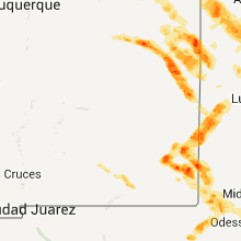
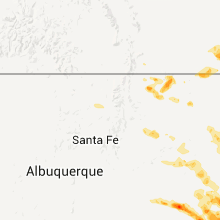
New Mexico
| Local Time | Report Details |
|---|---|
| 2:37 PM MDT | Quarter sized hail reported near Raton, NM, 65.9 miles ENE of Taos, NM |
| 2:37 PM MDT | Quarter sized hail reported near Raton, NM, 73.4 miles ENE of Taos, NM |
| 2:37 PM MDT | Quarter sized hail reported near Raton, NM, 65.7 miles ENE of Taos, NM |
| 6:00 PM MDT | Golf Ball sized hail reported near Lovington, NM, 74.6 miles ESE of Roswell, NM |
| 6:08 PM MDT | Hen Egg sized hail reported near Lovington, NM, 74.6 miles ESE of Roswell, NM, 658-708 pm cdt |
| 6:20 PM MDT | Quarter sized hail reported near Wagon Mound, NM, 56 miles ESE of Taos, NM |
| 6:21 PM MDT | Quarter sized hail reported near Hobbs, NM, 76.1 miles NW of Odessa, TX |
| 6:23 PM MDT | Quarter sized hail reported near Santa Rosa, NM, 51.4 miles SW of Tucumcari, NM, hail drifts cover u.s. highway 84 |
| 6:25 PM MDT | Quarter sized hail reported near Wagon Mound, NM, 56 miles ESE of Taos, NM |
| 6:50 PM MDT | Quarter sized hail reported near Carlsbad, NM, 68.7 miles S of Roswell, NM |
| 6:55 PM MDT | Quarter sized hail reported near Fort Sumner, NM, 38.9 miles SW of Tucumcari, NM |
| 7:10 PM MDT | Quarter sized hail reported near House, NM, 41 miles SSW of Tucumcari, NM |
| 7:10 PM MDT | Half Dollar sized hail reported near Hobbs, NM, 76.1 miles NW of Odessa, TX |
| 7:24 PM MDT | Ping Pong Ball sized hail reported near Eunice, NM, 67.2 miles NW of Odessa, TX |
| 7:51 PM MDT | Quarter sized hail reported near Carlsbad, NM, 77.3 miles S of Roswell, NM |
| 8:20 PM MDT | Golf Ball sized hail reported near Carlsbad, NM, 78.6 miles S of Roswell, NM |
| 8:29 PM MDT | Golf Ball sized hail reported near Clovis, NM, 60.8 miles SSE of Tucumcari, NM |
| 8:31 PM MDT | Golf Ball sized hail reported near Melrose, NM, 51.9 miles S of Tucumcari, NM |
| 8:35 PM MDT | Golf Ball sized hail reported near Melrose, NM, 51.9 miles S of Tucumcari, NM |
| 8:40 PM MDT | Softball sized hail reported near Melrose, NM, 51.9 miles S of Tucumcari, NM |
| 8:50 PM MDT | Golf Ball sized hail reported near Melrose, NM, 51.9 miles S of Tucumcari, NM |
| 8:50 PM MDT | Golf Ball sized hail reported near Portales, NM, 71.9 miles SSE of Tucumcari, NM |
| 9:08 PM MDT | Tennis Ball sized hail reported near Floyd, NM, 61.1 miles SSE of Tucumcari, NM |
| 9:10 PM MDT | Softball sized hail reported near Floyd, NM, 61.1 miles SSE of Tucumcari, NM, broke skylights out of the roof |
| 9:15 PM MDT | Quarter sized hail reported near Portales, NM, 73.9 miles SSE of Tucumcari, NM |
| 9:15 PM MDT | Baseball sized hail reported near Portales, NM, 67.7 miles SSE of Tucumcari, NM |
| 10:15 PM MDT | Baseball sized hail reported near Dora, NM, 78.7 miles ENE of Roswell, NM |
| 12:11 AM MDT | Quarter sized hail reported near Clovis, NM, 64.5 miles SSE of Tucumcari, NM |
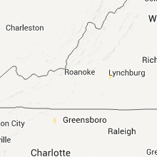
North Carolina
| Local Time | Report Details |
|---|---|
| 4:45 PM EDT | Large tree blocking the road about 200 feet northwest of the intersection of highway 221 and south pea ridge road which is on the east side of henriett in rutherford county NC, 53.4 miles W of Charlotte, NC |
| 4:55 PM EDT | A public report first indicated trees down in ellenboro. the ellenboro volunteer fire department said not aware of any trees down around ellenboro...but confirmed trees in rutherford county NC, 50.6 miles ENE of Greenville, SC |
| 6:00 PM EDT | Tree dow in stokes county NC, 69.9 miles S of Roanoke, VA |
| 8:50 PM EDT | 2 trees dow in iredell county NC, 51 miles N of Charlotte, NC |
| 8:54 PM EDT | A spotter near sheffield had a wind gust near 60 mph. he saw and heard trees snapping and crashing to the ground. no hai in davie county NC, 50.7 miles N of Charlotte, NC |
| 8:56 PM EDT | 2 trees down and part of a barn blown down on edwards road near mocksvill in davie county NC, 49.3 miles NNE of Charlotte, NC |
| 9:50 PM EDT | Fallen limbs brought down a powerline in east spence in rowan county NC, 39.6 miles NE of Charlotte, NC |
| 9:50 PM EDT | Two powerlines down in the far western part of rowan count in rowan county NC, 27.2 miles N of Charlotte, NC |
| 9:55 PM EDT | Tree down at corner of 704 east and steele r in stokes county NC, 54.1 miles S of Roanoke, VA |
| 10:12 PM EDT | Tree down along hwy 8 and gentry roa in stokes county NC, 58.9 miles SSW of Roanoke, VA |
| 10:15 PM EDT | Two powerlines were brought down by fallen limbs between rockwell and gold hil in rowan county NC, 33.4 miles NE of Charlotte, NC |
Idaho
| Local Time | Report Details |
|---|---|
| 2:06 PM PDT | Half Dollar sized hail reported near Winchester, ID, 36.5 miles NW of Grangeville, ID |
Colorado
| Local Time | Report Details |
|---|---|
| 3:39 PM MDT | Half Dollar sized hail reported near Pritchett, CO, 112.5 miles ESE of Pueblo, CO |
| 3:47 PM MDT | Hen Egg sized hail reported near Springfield, CO, 110.7 miles ESE of Pueblo, CO |
| 4:07 PM MDT | Ping Pong Ball sized hail reported near Springfield, CO, 110.3 miles ESE of Pueblo, CO, covering ground to 3 inch depth. |
| 4:25 PM MDT | Quarter sized hail reported near Pritchett, CO, 115.5 miles ESE of Pueblo, CO |
| 4:25 PM MDT | Quarter sized hail reported near Springfield, CO, 111.4 miles ESE of Pueblo, CO |
| 4:50 PM MDT | Quarter sized hail reported near Springfield, CO, 102 miles WSW of Garden City, KS |
Pennsylvania
| Local Time | Report Details |
|---|---|
| 5:51 PM EDT | Trees down in west decatu in clearfield county PA, 23.9 miles WNW of State College, PA |
South Dakota
| Local Time | Report Details |
|---|---|
| 4:30 PM MDT | Quarter sized hail reported near Belle Fourche, SD, 44.9 miles NNW of Rapid City, SD |
| 4:40 PM MDT | Hen Egg sized hail reported near Belle Fourche, SD, 42.3 miles NNW of Rapid City, SD |
| 5:16 PM MDT | Quarter sized hail reported near Custer, SD, 26.6 miles SSW of Rapid City, SD |
| 6:05 PM MDT | Golf Ball sized hail reported near Sturgis, SD, 22.9 miles N of Rapid City, SD |
| 6:45 PM MDT | Storm damage reported in meade county SD, 28.1 miles NE of Rapid City, SD |
| 7:52 PM MDT | Quarter sized hail reported near Scenic, SD, 60.5 miles ESE of Rapid City, SD |
Nebraska
| Local Time | Report Details |
|---|---|
| 4:30 PM MDT | Delayed report. estimated 50-60 mph wind gusts which brought down tree limb in perkins county NE, 33.2 miles WSW of North Platte, NE |
| 5:00 PM MDT | Golf Ball sized hail reported near Whitman, NE, 68.3 miles NW of North Platte, NE |
Virginia
| Local Time | Report Details |
|---|---|
| 7:17 PM EDT | Shingles off roof in campbell county VA, 53.7 miles E of Roanoke, VA |
| 7:43 PM EDT | Tree down blocking road in clarke county VA, 77.9 miles W of Baltimore, MD |
| 7:43 PM EDT | Tree down on oakville road in appomattox county VA, 60.9 miles ENE of Roanoke, VA |
| 8:10 PM EDT | 3000 customers without power in south roanoke. dispatch reported eight trees down in south roanoke. locations of downed trees were...nottingham road....27th and richeli in city of roanoke county VA, 2.2 miles SSW of Roanoke, VA |
| 8:10 PM EDT | 3000 customers without power in south roanoke. tree across intersection of 27th street and richelieu avenue. large limbs were downed across powerlines at the intersecti in city of roanoke county VA, 2.2 miles SSW of Roanoke, VA |
| 8:21 PM EDT | Tree down on bear creek road in campbell county VA, 50.2 miles E of Roanoke, VA |
| 8:35 PM EDT | Tree down on irvindale road in campbell county VA, 57.1 miles E of Roanoke, VA |
| 8:38 PM EDT | Tree down on hat creek road in campbell county VA, 57.4 miles E of Roanoke, VA |
| 8:43 PM EDT | Trees and power lines down in campbell county VA, 57.3 miles ESE of Roanoke, VA |
| 9:10 PM EDT | Trees and powerlines down along egg farm r in patrick county VA, 39.4 miles SSW of Roanoke, VA |
| 9:33 PM EDT | Trees down in madison county VA, 63.3 miles NNW of Richmond, VA |
Connect with Interactive Hail Maps