

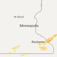
Hail Map for Friday, June 16, 2017

Number of Impacted Households on 6/16/2017
0
Impacted by 1" or Larger Hail
0
Impacted by 1.75" or Larger Hail
0
Impacted by 2.5" or Larger Hail
Square Miles of Populated Area Impacted on 6/16/2017
0
Impacted by 1" or Larger Hail
0
Impacted by 1.75" or Larger Hail
0
Impacted by 2.5" or Larger Hail


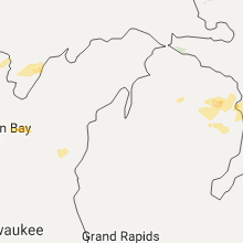


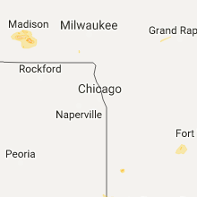


Cities Most Affected by Hail Storms of 6/16/2017
| Hail Size | Demographics of Zip Codes Affected | ||||||
|---|---|---|---|---|---|---|---|
| City | Count | Average | Largest | Pop Density | House Value | Income | Age |
| Genoa, NE | 5 | 1.95 | 2.50 | 5 | $52k | $32.4k | 41.5 |
| Fairbury, NE | 4 | 2.00 | 2.75 | 17 | $42k | $31.2k | 46.2 |
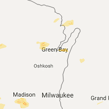
| Arcadia, WI | 4 | 2.00 | 2.50 | 34 | $74k | $36.7k | 37.1 |
| Whitehall, WI | 4 | 1.88 | 2.00 | 38 | $69k | $35.8k | 41.3 |
| Independence, WI | 3 | 2.00 | 2.50 | 20 | $63k | $31.5k | 39.7 |
| Osage City, KS | 2 | 2.25 | 2.50 | 27 | $72k | $35.6k | 42.1 |
| Rochester, MN | 2 | 1.75 | 1.75 | 419 | $95k | $44.8k | 35.0 |
| Geneva, NE | 1 | 2.75 | 2.75 | 25 | $62k | $34.5k | 44.2 |
| Barnes, KS | 1 | 2.75 | 2.75 | 3 | $21k | $26.9k | 48.3 |
| Randolph, KS | 1 | 2.75 | 2.75 | 4 | $67k | $38.0k | 45.6 |
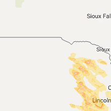
| Lincoln, NE | 1 | 2.50 | 2.50 | 5051 | $74k | $26.8k | 26.7 |
| Washington, KS | 1 | 2.50 | 2.50 | 13 | $40k | $30.9k | 47.3 |
| Pleasant Dale, NE | 1 | 2.00 | 2.00 | 13 | $108k | $50.1k | 44.4 |
| Aurora, NE | 1 | 2.00 | 2.00 | 30 | $81k | $38.9k | 40.7 |
| Osceola, NE | 1 | 1.75 | 1.75 | 5 | $61k | $37.8k | 45.0 |
| Lyndon, KS | 1 | 1.75 | 1.75 | 14 | $64k | $41.0k | 41.9 |
| Hebron, NE | 1 | 1.75 | 1.75 | 11 | $54k | $31.4k | 50.7 |
| Topeka, KS | 1 | 1.75 | 1.75 | 244 | $147k | $73.8k | 43.9 |
| Monroe, NE | 1 | 1.75 | 1.75 | 6 | $63k | $38.6k | 44.7 |
| Stewartville, MN | 1 | 1.75 | 1.75 | 87 | $104k | $46.6k | 36.6 |
| Norfolk, NE | 1 | 1.75 | 1.75 | 163 | $84k | $36.2k | 36.2 |
| Battle Creek, NE | 1 | 1.75 | 1.75 | 15 | $79k | $41.4k | 39.7 |
| Exeter, NE | 1 | 1.75 | 1.75 | 3 | $47k | $38.6k | 46.7 |
Hail and Wind Damage Spotted on 6/16/2017
Filter by Report Type:Hail ReportsWind Reports
States Impacted
Iowa, Pennsylvania, Arkansas, Wisconsin, Mississippi, Michigan, Minnesota, Illinois, Nebraska, South Carolina, Virginia, New York, Indiana, North Carolina, Montana, Alabama, Missouri, Kansas, LouisianaIowa
| Local Time | Report Details |
|---|---|
| 8:20 AM CDT | Partial roof and wall collapse on menards warehouse building. time estimated from rada in pottawattamie county IA, 29.3 miles ENE of Omaha, NE |
| 7:22 PM CDT | Quarter sized hail reported near Pomeroy, IA, 27.4 miles ESE of Storm Lake, IA, hail sized has now increased to quarters. |
| 7:40 PM CDT | Storm damage reported in harrison county IA, 38.2 miles N of Omaha, NE |
| 7:55 PM CDT | Roof blown off industrial building. widespread tree damage... in town... and west of tow in harrison county IA, 35.2 miles NNE of Omaha, NE |
| 8:00 PM CDT | Roof damaged from 5 inch limb blown onto hom in pottawattamie county IA, 4.4 miles ESE of Omaha, NE |
| 8:15 PM CDT | Large trees blown down. windows on house broke in mills county IA, 17.1 miles SSE of Omaha, NE |
| 8:35 PM CDT | Storm damage reported in shelby county IA, 38.2 miles NE of Omaha, NE |
| 8:35 PM CDT | Very large trees blocking the road in fremont county IA, 34 miles SSE of Omaha, NE |
| 8:38 PM CDT | Trees down onto road. time estimated in pottawattamie county IA, 25.8 miles E of Omaha, NE |
| 8:49 PM CDT | Several trees down. estimated 60 mph in fremont county IA, 33.1 miles SSE of Omaha, NE |
| 8:50 PM CDT | Broken tree branches across town along with power outage in cass county IA, 41.7 miles E of Omaha, NE |
| 8:55 PM CDT | Broken tree branches and power outage in cass county IA, 44.9 miles E of Omaha, NE |
| 9:01 PM CDT | Storm damage reported in cass county IA, 41.7 miles E of Omaha, NE |
| 9:05 PM CDT | Trees and power lines down. time estimated in montgomery county IA, 50.2 miles E of Omaha, NE |
| 9:36 PM CDT | Reports of non-specific building damage near the adams/taylor county line. also numerous trees down around the county. damage was most extensive in the southern portion in adams county IA, 66.5 miles ESE of Omaha, NE |
| 9:36 PM CDT | Tree limbs and power lines dow in adams county IA, 65.4 miles ESE of Omaha, NE |
| 9:42 PM CDT | *** 1 inj *** 3 unsecured camper trailers were blown from camp site into the lake. 1 with minor injurie in taylor county IA, 68.6 miles ESE of Omaha, NE |
| 10:15 PM CDT | At iowa veterans hom in marshall county IA, 48.7 miles NE of Des Moines, IA |
| 10:49 PM CDT | 1 large partially rotten tree limb dow in delaware county IA, 35.9 miles NNE of Cedar Rapids, IA |
Pennsylvania
| Local Time | Report Details |
|---|---|
| 3:17 PM EDT | Wires down on 168 paradise dr in westmoreland county PA, 21.5 miles E of Pittsburgh, PA |
| 6:21 PM EDT | Tree down blocking buffalo run road in centre county PA, 8.4 miles W of State College, PA |
Arkansas
| Local Time | Report Details |
|---|---|
| 2:30 PM CDT | Half Dollar sized hail reported near Luxora, AR, 45.9 miles N of Memphis, TN, half dollar sized hail falling near burdette on interstate 55. |
| 2:45 PM CDT | Half Dollar sized hail reported near Osceola, AR, 38.1 miles N of Memphis, TN, half dollar sized hail dotting the ground north of osceola. |
Wisconsin
| Local Time | Report Details |
|---|---|
| 2:38 PM CDT | Storm damage reported in shawano county WI, 34 miles WNW of Green Bay, WI |
| 5:47 PM CDT | Quarter sized hail reported near Fountain City, WI, 30.8 miles NW of La Crosse, WI |
| 5:47 PM CDT | Large tree down... estimated 12 inch diamete in buffalo county WI, 30.8 miles NW of La Crosse, WI |
| 6:00 PM CDT | Half Dollar sized hail reported near Cochrane, WI, 40.4 miles NW of La Crosse, WI |
| 6:02 PM CDT | Quarter sized hail reported near Fountain City, WI, 30.8 miles NW of La Crosse, WI, hail ongoing at time of report. |
| 6:12 PM CDT | Quarter sized hail reported near Arcadia, WI, 32.6 miles NNW of La Crosse, WI |
| 6:12 PM CDT | Golf Ball sized hail reported near Arcadia, WI, 34.8 miles NNW of La Crosse, WI |
| 6:12 PM CDT | Tennis Ball sized hail reported near Arcadia, WI, 33.1 miles NNW of La Crosse, WI, windshields smashed on several vehicles. |
| 6:13 PM CDT | Half Dollar sized hail reported near Arcadia, WI, 32.4 miles NNW of La Crosse, WI, half dollar hail reported in arcadia around 613 pm. relayed via wkbt. |
| 6:18 PM CDT | Hen Egg sized hail reported near Arcadia, WI, 34.2 miles NNW of La Crosse, WI, relayed via wkbt. |
| 6:22 PM CDT | Golf Ball sized hail reported near Arcadia, WI, 35.9 miles NNW of La Crosse, WI, golf ball hail reported between independence and arcadia. relayed via mpx. |
| 6:30 PM CDT | Ping Pong Ball sized hail reported near Cochrane, WI, 41.9 miles NNW of La Crosse, WI, lots of crop damage reported. |
| 6:35 PM CDT | Tennis Ball sized hail reported near Independence, WI, 38.7 miles NNW of La Crosse, WI, hail size estimated from photo. time estimated from radar. |
| 6:36 PM CDT | Hen Egg sized hail reported near Whitehall, WI, 39 miles N of La Crosse, WI, relayed via wkbt. |
| 6:36 PM CDT | Hen Egg sized hail reported near Whitehall, WI, 38.2 miles N of La Crosse, WI, relayed via wkbt. |
| 6:36 PM CDT | Golf Ball sized hail reported near Whitehall, WI, 39 miles N of La Crosse, WI, relayed via wkbt. |
| 6:38 PM CDT | Golf Ball sized hail reported near Independence, WI, 38.7 miles NNW of La Crosse, WI |
| 6:38 PM CDT | Golf Ball sized hail reported near Whitehall, WI, 37.9 miles N of La Crosse, WI |
| 6:40 PM CDT | Golf Ball sized hail reported near Independence, WI, 40.4 miles N of La Crosse, WI, hail damage to vehicles and crops reported. |
| 6:57 PM CDT | Large branch blown down. possibly struck a vehicle. reported near walmart. relayed via wxo in la crosse county WI, 3.6 miles SE of La Crosse, WI |
| 7:02 PM CDT | 1 tree down in downtown la crosse; 1 tree down northern losey blvd; light pole down at copeland par in la crosse county WI, 0.8 miles NE of La Crosse, WI |
| 7:25 PM CDT | Tree blown down near us highway 10 and county in clark county WI, 57 miles NNE of La Crosse, WI |
| 7:25 PM CDT | Ping Pong Ball sized hail reported near Fairchild, WI, 56.3 miles NNE of La Crosse, WI, local business reports ping pong sized hail. |
| 7:27 PM CDT | Half Dollar sized hail reported near Fairchild, WI, 56.7 miles NNE of La Crosse, WI, mping reported. |
| 7:27 PM CDT | Ping Pong Ball sized hail reported near Fairchild, WI, 56.3 miles NNE of La Crosse, WI |
| 7:30 PM CDT | Large tree down in vernon county WI, 28.7 miles SE of La Crosse, WI |
| 7:48 PM CDT | Quarter sized hail reported near Willard, WI, 69.3 miles NNE of La Crosse, WI, hail ranging from the size of pea to quarters. |
| 10:03 PM CDT | Quarter sized hail reported near Mount Horeb, WI, 17.9 miles WSW of Madison, WI, based on picture posted on social media. |
| 10:03 PM CDT | Half Dollar sized hail reported near Mount Horeb, WI, 17.9 miles WSW of Madison, WI, broadcast media forwarded a picture from social media. |
| 11:00 PM CDT | Large tree snapped near county dk and debaker l in kewaunee county WI, 16 miles NE of Green Bay, WI |
Mississippi
| Local Time | Report Details |
|---|---|
| 3:35 PM CDT | Tree and power line dow in carroll county MS, 66.9 miles W of Starkville, MS |
| 4:19 PM CDT | A few trees down across hwy 1 in webster county MS, 22.8 miles NW of Starkville, MS |
| 4:20 PM CDT | Numerous trees and powerlines were down in arcola along highwy 43 in washington county MS, 69 miles ENE of Bastrop, LA |
| 4:20 PM CDT | A few trees down on sawyer loop r in montgomery county MS, 52.6 miles W of Starkville, MS |
| 4:25 PM CDT | Tree down on a mccarter roa in webster county MS, 20 miles NW of Starkville, MS |
| 4:35 PM CDT | Trees down near city hall in downtown kilmichael. numerous trees were blocking roads around the count in montgomery county MS, 43.8 miles W of Starkville, MS |
| 4:45 PM CDT | Trees down on the trac in choctaw county MS, 29.6 miles WSW of Starkville, MS |
| 4:55 PM CDT | Trees and power lines dow in noxubee county MS, 28.9 miles SSE of Starkville, MS |
| 4:58 PM CDT | Trees down along hwy 1 in choctaw county MS, 28 miles WSW of Starkville, MS |
| 5:00 PM CDT | Tree down on a she in choctaw county MS, 23.8 miles WSW of Starkville, MS |
| 5:08 PM CDT | Tree down along highway 1 in attala county MS, 33.4 miles WSW of Starkville, MS |
| 5:17 PM CDT | Several trees down along old highway 6 in washington county MS, 69.7 miles ENE of Bastrop, LA |
| 5:25 PM CDT | Tree fell on a house on northwood d in winston county MS, 26.7 miles SW of Starkville, MS |
| 5:30 PM CDT | Numerous trees were down around louisvile in winston county MS, 26.9 miles SSW of Starkville, MS |
| 5:30 PM CDT | Trees and power lines dow in oktibbeha county MS, 1 miles WNW of Starkville, MS |
| 5:30 PM CDT | A few trees were down around the homewood communit in scott county MS, 39.5 miles E of Jackson, MS |
| 5:30 PM CDT | A few trees were down around the homewood communit in scott county MS, 39.5 miles E of Jackson, MS |
| 5:30 PM CDT | Tree dow in leflore county MS, 74.6 miles N of Jackson, MS |
| 5:35 PM CDT | Numerous trees and powerlines were down in arcola along highwy 43 in washington county MS, 69 miles ENE of Bastrop, LA |
| 5:47 PM CDT | Tree down on wildcat r in lauderdale county MS, 65.2 miles S of Starkville, MS |
| 5:50 PM CDT | Tree down on a mccarter roa in webster county MS, 20 miles NW of Starkville, MS |
| 5:50 PM CDT | Several trees down across bolivar count in bolivar county MS, 96.3 miles NE of Bastrop, LA |
| 5:55 PM CDT | Trees and power lines dow in noxubee county MS, 28.9 miles SSE of Starkville, MS |
| 5:58 PM CDT | A couple blocking highway 12 near ackerma in choctaw county MS, 20.8 miles WSW of Starkville, MS |
| 6:00 PM CDT | 3 homes sustained wind damag in bolivar county MS, 87.2 miles NE of Bastrop, LA |
| 6:08 PM CDT | Tree dow in jasper county MS, 59.6 miles E of Jackson, MS |
| 6:08 PM CDT | Tree down across binnsville r in kemper county MS, 48 miles SSE of Starkville, MS |
| 6:10 PM CDT | Tree dow in leflore county MS, 81.7 miles W of Starkville, MS |
| 6:16 PM CDT | A few trees down in the around airport and liberty church r in newton county MS, 61.5 miles E of Jackson, MS |
| 6:20 PM CDT | Quarter sized hail reported near Lucedale, MS, 36 miles WNW of Mobile, AL, quarter size hail measured near lucedale... ms. pictures obtained on social media. |
| 6:25 PM CDT | Trees and power lines were down in along highway 80 in hickor in newton county MS, 67.3 miles E of Jackson, MS |
| 6:25 PM CDT | Numerous trees and power lines down across the west portion of the count in holmes county MS, 60.8 miles N of Jackson, MS |
| 6:25 PM CDT | Tree debris downed blocking ms highway 12 near rosebank-mt olive r in holmes county MS, 60 miles N of Jackson, MS |
| 6:45 PM CDT | Tree on a trailer in avo in washington county MS, 59.1 miles ENE of Bastrop, LA |
| 6:45 PM CDT | Numerous trees down across washington count in washington county MS, 66.4 miles NE of Bastrop, LA |
| 7:00 PM CDT | Numerous trees down across the count in washington county MS, 67.5 miles ENE of Bastrop, LA |
| 7:05 PM CDT | Quarter sized hail reported near Meridian, MS, 78.5 miles WNW of Camden, AL |
| 7:10 PM CDT | A tree was downed across cr 671 east of quitma in clarke county MS, 79.3 miles W of Camden, AL |
| 7:14 PM CDT | Tree down on williams/eden midway r in yazoo county MS, 45.2 miles N of Jackson, MS |
| 7:20 PM CDT | Numerous trees down across yazoo count in yazoo county MS, 40.9 miles NNW of Jackson, MS |
| 7:24 PM CDT | Tree down across hwy 1 in yazoo county MS, 37.3 miles N of Jackson, MS |
| 7:45 PM CDT | Tree downed on poole creek rd. estimated wind gusts 40-50 mp in jones county MS, 80.6 miles ESE of Jackson, MS |
| 8:00 PM CDT | Numerous trees down across madison count in madison county MS, 12.5 miles NNE of Jackson, MS |
| 8:00 PM CDT | Large tree downed across jimmy williams rd near lorance rd. report via social medi in hinds county MS, 15.5 miles WNW of Jackson, MS |
| 8:02 PM CDT | Trees were downed in the beaver creek subdivision in ridgelan in madison county MS, 10.4 miles NNE of Jackson, MS |
| 8:10 PM CDT | Trees dow in hinds county MS, 9.2 miles WNW of Jackson, MS |
| 8:10 PM CDT | A tree was split at old canton rd and westbrook rd in jackso in hinds county MS, 5.7 miles NNE of Jackson, MS |
| 8:15 PM CDT | A tree was downed on cooper rd in jackso in hinds county MS, 4.8 miles SW of Jackson, MS |
| 8:15 PM CDT | Trees and lines downed on childress d in hinds county MS, 3.6 miles N of Jackson, MS |
| 8:15 PM CDT | Trees down all throughout the count in warren county MS, 41.1 miles W of Jackson, MS |
| 8:15 PM CDT | Quarter sized hail reported near Mize, MS, 47.3 miles SE of Jackson, MS |
| 8:18 PM CDT | A tree was downed on a house in the crossgates neighborhoo in rankin county MS, 9.4 miles E of Jackson, MS |
| 8:18 PM CDT | Tree downed on mary ann dr in pear in rankin county MS, 4.3 miles ESE of Jackson, MS |
| 8:20 PM CDT | Trees dow in rankin county MS, 10.6 miles E of Jackson, MS |
| 8:20 PM CDT | A few windows blown out of a home on the 3rd floor along with some roof damage on south pearson r in rankin county MS, 4 miles SE of Jackson, MS |
| 8:25 PM CDT | Trees downed across monterey r in rankin county MS, 8.3 miles SE of Jackson, MS |
| 8:25 PM CDT | Powerlines were downed on stubbs r in hinds county MS, 15.8 miles SW of Jackson, MS |
| 8:27 PM CDT | Shingles were blown off the roof of a home... a wooden fence was blown down... and doors were blown off a storage building in florence. also a tree was downed in the br in rankin county MS, 10.7 miles SSE of Jackson, MS |
| 8:32 PM CDT | Several trees downed in the clear branch communit in rankin county MS, 15.1 miles S of Jackson, MS |
| 8:34 PM CDT | Tree down on wildcat r in lauderdale county MS, 64.6 miles S of Starkville, MS |
| 8:39 PM CDT | Tree on a power line; power line caught on fir in copiah county MS, 20.2 miles SSW of Jackson, MS |
| 8:42 PM CDT | Widespread of trees down across hwy 2 in copiah county MS, 28.2 miles S of Jackson, MS |
| 8:45 PM CDT | Trees downed on woodrow barnes rd. report via social medi in simpson county MS, 27.3 miles SE of Jackson, MS |
| 8:46 PM CDT | Widespread trees down on hwy 2 in copiah county MS, 28.8 miles SSW of Jackson, MS |
| 8:51 PM CDT | Tree reported on a home... people trapped insid in covington county MS, 57.2 miles SE of Jackson, MS |
| 8:52 PM CDT | Multiple trees down near hwy 53 in covington county MS, 57.6 miles SE of Jackson, MS |
| 8:55 PM CDT | Multiple trees down across the shivers communit in simpson county MS, 34.1 miles S of Jackson, MS |
| 9:05 PM CDT | Several trees downed along both cr 18 and cr 27. multiple homes sustained major roof damage due to both strong winds and falling tree in smith county MS, 52.2 miles SE of Jackson, MS |
| 9:05 PM CDT | Numerous trees down along highway 43 near new hebro in lawrence county MS, 41.6 miles SSE of Jackson, MS |
| 9:15 PM CDT | Tree fell on a vehicle on hwy 11 south ellisvill in jones county MS, 75.1 miles SE of Jackson, MS |
| 9:15 PM CDT | Trees and power lines downed countywide. some trees downed on shed in jefferson davis county MS, 51.5 miles SSE of Jackson, MS |
| 9:15 PM CDT | Trees and powerlines down along heucks retreat roa in lincoln county MS, 47.9 miles SSW of Jackson, MS |
| 9:16 PM CDT | Trees down along hwy 3 in covington county MS, 58.6 miles SE of Jackson, MS |
| 9:16 PM CDT | Tree downed on mason creek r in jones county MS, 60.3 miles SE of Jackson, MS |
| 9:17 PM CDT | Numerous trees downed in the big creek/hebron community area... including along mason creek rd and carter dees r in jones county MS, 60.3 miles SE of Jackson, MS |
| 9:20 PM CDT | Trees down near lloyd sta in lincoln county MS, 51.4 miles SSW of Jackson, MS |
| 9:20 PM CDT | A tree was downed across ben pitts r in jones county MS, 63.4 miles SE of Jackson, MS |
| 9:20 PM CDT | A tree was downed across ben pitts r in jones county MS, 63.4 miles SE of Jackson, MS |
| 9:20 PM CDT | Tree was downed across hebron centerville rd near morning star r in jones county MS, 63.9 miles SE of Jackson, MS |
| 9:21 PM CDT | Multiple trees downed. report via social medi in covington county MS, 64.7 miles SE of Jackson, MS |
| 9:22 PM CDT | Tree downed on river rd near ms hwy 58 in jones county MS, 67.6 miles SE of Jackson, MS |
| 9:22 PM CDT | A tree fell on power lines along lowery creek r in jones county MS, 67.7 miles SE of Jackson, MS |
| 9:23 PM CDT | Several trees were downed on knight ci in jones county MS, 65.7 miles SE of Jackson, MS |
| 9:25 PM CDT | A tree was downed onto a power line on ms highway 588 near blackwell loo in jones county MS, 68.4 miles SE of Jackson, MS |
| 9:27 PM CDT | A tree was downed across dale keyes r in jones county MS, 68.8 miles SE of Jackson, MS |
| 9:28 PM CDT | A tree was downed on a power line along guthrie carter r in jones county MS, 71.9 miles SE of Jackson, MS |
| 9:29 PM CDT | Tree limbs downed onto power lines causing a fire along jordan r in jones county MS, 73.4 miles SE of Jackson, MS |
| 9:32 PM CDT | Tree down on preston s in lamar county MS, 70.4 miles SSE of Jackson, MS |
| 9:33 PM CDT | Tree across hwy 589 and 1st s in lamar county MS, 70.7 miles SSE of Jackson, MS |
| 9:33 PM CDT | A tree was downed on a power line along old school house r in jones county MS, 77.4 miles SE of Jackson, MS |
| 9:34 PM CDT | Tree down on crossland r in lamar county MS, 73.1 miles SSE of Jackson, MS |
| 9:35 PM CDT | A tree was downed across the road at hoy rd and houston r in jones county MS, 72.3 miles ESE of Jackson, MS |
| 9:37 PM CDT | Trees downed on monroe r in forrest county MS, 80.7 miles SE of Jackson, MS |
| 9:43 PM CDT | Multiple trees were downed on macedonia r in forrest county MS, 82.9 miles NW of Mobile, AL |
| 9:50 PM CDT | Power lines downed across road at us 49 and us 9 in forrest county MS, 81.7 miles WNW of Mobile, AL |
| 9:54 PM CDT | Tree across gross bunker hill r in marion county MS, 67 miles SSE of Jackson, MS |
| 9:54 PM CDT | Tree down on williamsburg r in marion county MS, 67.5 miles SSE of Jackson, MS |
| 9:54 PM CDT | Multiple trees downed across forrest co... including a large tree down across old hwy 49 w near dixi in forrest county MS, 82.6 miles WNW of Mobile, AL |
| 9:55 PM CDT | Tree down across conerly and stuckey r in marion county MS, 68.5 miles SSE of Jackson, MS |
| 9:55 PM CDT | Tree across hwy 58 in marion county MS, 75.5 miles SSE of Jackson, MS |
| 9:55 PM CDT | Roof damage on gates rd near wolf howling r in marion county MS, 71.2 miles SSE of Jackson, MS |
| 9:55 PM CDT | Tree down on little creek r in lamar county MS, 83.5 miles SSE of Jackson, MS |
| 9:56 PM CDT | Tree on a car on cedar grove r in marion county MS, 70.8 miles SSE of Jackson, MS |
| 10:07 PM CDT | Trees down on schley st in brookly in forrest county MS, 72.3 miles WNW of Mobile, AL |
| 10:45 PM CDT | Tree fell into a house causing extensive damage to the house and carport. multiple trees down in the wiggins are in stone county MS, 65.7 miles W of Mobile, AL |
| 11:24 PM CDT | Nnw 31.1 g 62.9 kt at range a rear... port of pascagoula... m in jackson county MS, 36.2 miles SW of Mobile, AL |
Michigan
| Local Time | Report Details |
|---|---|
| 3:45 PM CDT | Large tree broken near the base. estimated around 10 inches in diameter. time estimated via rada in menominee county MI, 71.2 miles S of Marquette, MI |
| 4:19 PM CDT | Several trees down near m-35. report received via social medi in menominee county MI, 73.6 miles NNE of Green Bay, WI |
Minnesota
| Local Time | Report Details |
|---|---|
| 3:56 PM CDT | Trees dow in blue earth county MN, 73.2 miles NW of Mason City, IA |
| 4:50 PM CDT | Quarter sized hail reported near Rochester, MN, 61.3 miles WNW of La Crosse, WI, dime to quarter sized hail reported in southeast rochester. relayed via kttc. |
| 4:50 PM CDT | Ping Pong Ball sized hail reported near Stewartville, MN, 54.9 miles W of La Crosse, WI |
| 4:55 PM CDT | Half Dollar sized hail reported near Rochester, MN, 58.9 miles WNW of La Crosse, WI, hail size estimated from facebook photo. |
| 4:55 PM CDT | Golf Ball sized hail reported near Rochester, MN, 56.5 miles WNW of La Crosse, WI, size estimated from photo via twitter. time estimated from radar. |
| 4:56 PM CDT | Golf Ball sized hail reported near Rochester, MN, 60.4 miles WNW of La Crosse, WI, golf ball sized hail reported on the southeast side of rochester. relayed via kaal. |
| 4:59 PM CDT | Ping Pong Ball sized hail reported near Rochester, MN, 56.6 miles WNW of La Crosse, WI |
| 5:05 PM CDT | Ping Pong Ball sized hail reported near Rochester, MN, 60 miles WNW of La Crosse, WI, hail between quarter and golf ball size reported. |
| 5:10 PM CDT | Golf Ball sized hail reported near Stewartville, MN, 54.9 miles W of La Crosse, WI |
| 5:15 PM CDT | Ping Pong Ball sized hail reported near Spring Valley, MN, 53.2 miles W of La Crosse, WI |
| 5:15 PM CDT | Photo on twitter of large tree snapped at the base at marcusen park. time estimated from rada in mower county MN, 37.1 miles NNE of Mason City, IA |
| 5:48 PM CDT | Numerous trees damaged by strong winds in lanesboro. relayed via kaa in fillmore county MN, 36.5 miles W of La Crosse, WI |
| 5:56 PM CDT | Number of trees down at golf course and another across a highway. pea size hail in town... but larger to the south (no size given in fillmore county MN, 36.5 miles W of La Crosse, WI |
| 6:00 PM CDT | Numerous trees down along highway 23 near highland... up to 6 inch diamete in fillmore county MN, 33.7 miles WSW of La Crosse, WI |
| 6:02 PM CDT | Trees down in the city of winon in winona county MN, 26.1 miles NW of La Crosse, WI |
Illinois
| Local Time | Report Details |
|---|---|
| 4:20 PM CDT | A few large tree limbs blown down and the side of a metal shed blown outwar in bond county IL, 49.9 miles ENE of Saint Louis, MO |
Nebraska
| Local Time | Report Details |
|---|---|
| 4:23 PM CDT | Quarter sized hail reported near Brunswick, NE, 35.7 miles ESE of Oneill, NE |
| 4:58 PM CDT | Half Dollar sized hail reported near Neligh, NE, 41.5 miles ESE of Oneill, NE |
| 5:15 PM CDT | Grain bin destroye in wayne county NE, 74.7 miles ESE of Oneill, NE |
| 5:18 PM CDT | Golf Ball sized hail reported near Norfolk, NE, 64.1 miles ESE of Oneill, NE |
| 5:23 PM CDT | Golf Ball sized hail reported near Battle Creek, NE, 62 miles ESE of Oneill, NE |
| 5:37 PM CDT | Storm damage reported in madison county NE, 70.7 miles ESE of Oneill, NE |
| 5:38 PM CDT | Storm damage reported in madison county NE, 70.7 miles ESE of Oneill, NE |
| 5:49 PM CDT | Quarter sized hail reported near Norfolk, NE, 71.8 miles ESE of Oneill, NE |
| 6:15 PM CDT | Ping Pong Ball sized hail reported near Newman Grove, NE, 64 miles NNE of Grand Island, NE |
| 6:18 PM CDT | Quarter sized hail reported near Lindsay, NE, 59.3 miles NE of Grand Island, NE |
| 6:23 PM CDT | Roof blown off building. winds estimated at 60 mp in platte county NE, 74.9 miles NE of Grand Island, NE |
| 6:30 PM CDT | Quarter sized hail reported near Lindsay, NE, 63.3 miles NNE of Grand Island, NE |
| 6:45 PM CDT | Half Dollar sized hail reported near Platte Center, NE, 62.3 miles NE of Grand Island, NE |
| 6:49 PM CDT | Hen Egg sized hail reported near Genoa, NE, 52.4 miles NE of Grand Island, NE |
| 6:50 PM CDT | Golf Ball sized hail reported near Genoa, NE, 51.4 miles NE of Grand Island, NE, report via facebook. |
| 6:50 PM CDT | Tennis Ball sized hail reported near Genoa, NE, 52.4 miles NE of Grand Island, NE |
| 6:52 PM CDT | Golf Ball sized hail reported near Genoa, NE, 49.8 miles NE of Grand Island, NE, quarter to golf ball size hail lasted for about 1 minute. |
| 6:52 PM CDT | Golf Ball sized hail reported near Genoa, NE, 49.4 miles NE of Grand Island, NE, quarter to golf ball size hail lasted for about 1 minute. |
| 6:54 PM CDT | Golf Ball sized hail reported near Monroe, NE, 53.9 miles NE of Grand Island, NE |
| 7:00 PM CDT | Quarter sized hail reported near Columbus, NE, 61.9 miles NE of Grand Island, NE |
| 7:10 PM CDT | Numerous street signs blown dow in dodge county NE, 39.8 miles NW of Omaha, NE |
| 7:11 PM CDT | Hen Egg sized hail reported near Aurora, NE, 18.2 miles ESE of Grand Island, NE, social media report. |
| 7:11 PM CDT | Quarter sized hail reported near Aurora, NE, 18.5 miles ESE of Grand Island, NE, report via em. |
| 7:12 PM CDT | Storm damage reported in dodge county NE, 39.8 miles NW of Omaha, NE |
| 7:14 PM CDT | Storm damage reported in dodge county NE, 38.6 miles NW of Omaha, NE |
| 7:14 PM CDT | Tree branches blown dow in dodge county NE, 31.1 miles WNW of Omaha, NE |
| 7:15 PM CDT | At the nws offic in douglas county NE, 22.2 miles W of Omaha, NE |
| 7:15 PM CDT | Trees and power lines blown dow in dodge county NE, 33.3 miles WNW of Omaha, NE |
| 7:15 PM CDT | Ping Pong Ball sized hail reported near Aurora, NE, 18.6 miles E of Grand Island, NE, report via em. |
| 7:15 PM CDT | Quarter sized hail reported near Genoa, NE, 42.4 miles NE of Grand Island, NE, time est by radar. |
| 7:17 PM CDT | Storm damage reported in dodge county NE, 31.1 miles WNW of Omaha, NE |
| 7:23 PM CDT | Several trees and powerlines down in dodge county NE, 31.1 miles WNW of Omaha, NE |
| 7:25 PM CDT | Storm damage reported in dodge county NE, 33.1 miles WNW of Omaha, NE |
| 7:28 PM CDT | Quarter sized hail reported near Silver Creek, NE, 43.1 miles NE of Grand Island, NE, 3 s of silver creek. nws employee reported quarter sized hail. |
| 7:32 PM CDT | At the nws offic in douglas county NE, 22.2 miles W of Omaha, NE |
| 7:33 PM CDT | Quarter sized hail reported near Henderson, NE, 29.6 miles ESE of Grand Island, NE, south if i-80 near henderson quarter sized hail. |
| 7:35 PM CDT | Fence blown dow in saunders county NE, 24 miles W of Omaha, NE |
| 7:35 PM CDT | 173rd and f. numerous trees down and transformers in douglas county NE, 3.6 miles W of Omaha, NE |
| 7:36 PM CDT | At the nws offic in douglas county NE, 22.2 miles W of Omaha, NE |
| 7:40 PM CDT | Storm damage reported in douglas county NE, 15.7 miles W of Omaha, NE |
| 7:44 PM CDT | Quarter sized hail reported near Osceola, NE, 44.9 miles ENE of Grand Island, NE, ongoing and getting more intense. |
| 7:45 PM CDT | Golf Ball sized hail reported near Osceola, NE, 44.6 miles ENE of Grand Island, NE |
| 7:48 PM CDT | Storm damage reported in sarpy county NE, 15.4 miles WSW of Omaha, NE |
| 7:50 PM CDT | Quarter sized hail reported near Shelby, NE, 51.2 miles ENE of Grand Island, NE, report and picture received via facebook. |
| 7:50 PM CDT | Trees dow in douglas county NE, 13.5 miles WSW of Omaha, NE |
| 7:51 PM CDT | Ping Pong Ball sized hail reported near Osceola, NE, 44.9 miles ENE of Grand Island, NE, em reported ping pong hail in osceola. |
| 7:53 PM CDT | Numerous trees down and damage to country club in saunders county NE, 27.1 miles SW of Omaha, NE |
| 7:55 PM CDT | 132nd and harrison area. big trees down along with several fences in the neighboo in douglas county NE, 3.6 miles W of Omaha, NE |
| 7:55 PM CDT | Storm damage reported in sarpy county NE, 17.7 miles WSW of Omaha, NE |
| 7:58 PM CDT | Storm damage reported in sarpy county NE, 18 miles WSW of Omaha, NE |
| 7:59 PM CDT | 132nd and cornhusker in douglas county NE, 3.6 miles W of Omaha, NE |
| 7:59 PM CDT | Storm damage reported in sarpy county NE, 20.8 miles SW of Omaha, NE |
| 8:00 PM CDT | Quarter sized hail reported near Exeter, NE, 48.4 miles ESE of Grand Island, NE, report and photo received via facebook. time estimated from radar. |
| 8:00 PM CDT | Widepsread tree and fence damag in sarpy county NE, 8.7 miles SW of Omaha, NE |
| 8:04 PM CDT | At omaha airpor in douglas county NE, 3.4 miles NE of Omaha, NE |
| 8:06 PM CDT | Storm damage reported in sarpy county NE, 8.7 miles SW of Omaha, NE |
| 8:10 PM CDT | Storm damage reported in sarpy county NE, 7 miles S of Omaha, NE |
| 8:10 PM CDT | Significant damage to multiple homes in the hyda hills neighborhoo in sarpy county NE, 11.1 miles S of Omaha, NE |
| 8:10 PM CDT | Trees topped and considerable roof damag in sarpy county NE, 10.5 miles S of Omaha, NE |
| 8:15 PM CDT | *** 4 inj *** substantial damage in the town. trees down on most roads. powerlines blown down. no power between louisville and plattsmouth and weeping water. county mai in cass county NE, 17.5 miles S of Omaha, NE |
| 8:15 PM CDT | Major tree damag in lancaster county NE, 52.5 miles WSW of Omaha, NE |
| 8:25 PM CDT | Quarter sized hail reported near Seward, NE, 59.1 miles WSW of Omaha, NE |
| 8:33 PM CDT | Quarter sized hail reported near Waco, NE, 48.7 miles E of Grand Island, NE, near hwy 34 and road v. |
| 8:35 PM CDT | Storm damage reported in lancaster county NE, 54.2 miles WSW of Omaha, NE |
| 8:35 PM CDT | Hen Egg sized hail reported near Pleasant Dale, NE, 61.1 miles WSW of Omaha, NE |
| 8:37 PM CDT | At the lincoln airpor in lancaster county NE, 50.5 miles WSW of Omaha, NE |
| 8:40 PM CDT | Several semis tipped over just east of 27th street on i-80. water over roads just south of there as wel in lancaster county NE, 49.6 miles SW of Omaha, NE |
| 8:40 PM CDT | Tennis Ball sized hail reported near Lincoln, NE, 49.6 miles SW of Omaha, NE, also 60 mph wind. |
| 8:48 PM CDT | Quarter sized hail reported near Lincoln, NE, 49.6 miles SW of Omaha, NE, at 48th and highway 2. 60 mph winds also. |
| 8:49 PM CDT | Numeorus reports of trees and power lines dow in lancaster county NE, 49.6 miles SW of Omaha, NE |
| 8:50 PM CDT | Several semis flipped in lincol in lancaster county NE, 49.6 miles SW of Omaha, NE |
| 8:57 PM CDT | Storm damage reported in saline county NE, 68.5 miles ESE of Grand Island, NE |
| 9:04 PM CDT | Storm damage reported in saline county NE, 67.2 miles ESE of Grand Island, NE |
| 9:04 PM CDT | Storm damage reported in saline county NE, 68.8 miles ESE of Grand Island, NE |
| 9:04 PM CDT | Quarter sized hail reported near Exeter, NE, 51.2 miles ESE of Grand Island, NE, hail ongoing. |
| 9:05 PM CDT | Two homes damaged from wind on west side of town. also a couple of homes had lightning damag in saline county NE, 75.9 miles SW of Omaha, NE |
| 9:05 PM CDT | Mobile home lost roof... north side of town. time estimate in gage county NE, 73 miles SW of Omaha, NE |
| 9:06 PM CDT | Half Dollar sized hail reported near Crete, NE, 68.8 miles SW of Omaha, NE |
| 9:10 PM CDT | Golf Ball sized hail reported near Exeter, NE, 54.9 miles ESE of Grand Island, NE, quarters to golf ball sized hail reported. |
| 9:12 PM CDT | Baseball sized hail reported near Geneva, NE, 48 miles ESE of Grand Island, NE, county reported golf ball sized hail in town with base ball sized hail reported 2 ne of geneva. |
| 9:13 PM CDT | Storm damage reported in saline county NE, 75.9 miles SW of Omaha, NE |
| 9:15 PM CDT | Very large trees uprooted. power lines blown dow in johnson county NE, 59.1 miles SSW of Omaha, NE |
| 9:34 PM CDT | Half inch hail. substantial tree and power line damage. pivots flippe in gage county NE, 76.7 miles N of Manhattan, KS |
| 9:35 PM CDT | Trees blown down onto the roa in gage county NE, 79.3 miles SW of Omaha, NE |
| 9:35 PM CDT | Quarter sized hail reported near Tobias, NE, 62.1 miles SE of Grand Island, NE, nickels to quarters sized hail. |
| 9:35 PM CDT | Tree and power line damage in town. time estimated in gage county NE, 75.9 miles N of Manhattan, KS |
| 9:39 PM CDT | Storm damage reported in gage county NE, 79.4 miles SW of Omaha, NE |
| 9:40 PM CDT | Power poles and trees snappe in gage county NE, 79.1 miles NNW of Manhattan, KS |
| 9:41 PM CDT | Quarter sized hail reported near Strang, NE, 55.9 miles SE of Grand Island, NE, public report of quarter sized hail 3 ese of strang. |
| 9:42 PM CDT | Storm damage reported in gage county NE, 79.1 miles NNW of Manhattan, KS |
| 9:47 PM CDT | Storm damage reported in gage county NE, 78.1 miles SSW of Omaha, NE |
| 9:48 PM CDT | Medium limbs blown dow in nemaha county NE, 55 miles SSE of Omaha, NE |
| 9:50 PM CDT | Quarter sized hail reported near Bruning, NE, 58.3 miles SE of Grand Island, NE, quarter sized hail reported 1 e of bruning. |
| 10:11 PM CDT | Golf Ball sized hail reported near Fairbury, NE, 70.6 miles SE of Grand Island, NE |
| 10:19 PM CDT | Golf Ball sized hail reported near Fairbury, NE, 75.7 miles SE of Grand Island, NE |
| 10:21 PM CDT | Quarter sized hail reported near Fairbury, NE, 76.8 miles NNW of Manhattan, KS |
| 10:25 PM CDT | Golf Ball sized hail reported near Hebron, NE, 72.8 miles SE of Grand Island, NE, quarters to golf balls sized hail. |
| 10:26 PM CDT | Golf Ball sized hail reported near Fairbury, NE, 75.8 miles NNW of Manhattan, KS |
| 10:27 PM CDT | Crystal springs weather statio in jefferson county NE, 73.3 miles NNW of Manhattan, KS |
| 10:45 PM CDT | Baseball sized hail reported near Fairbury, NE, 73.6 miles NW of Manhattan, KS, golf ball to baseball size hail. |
South Carolina
| Local Time | Report Details |
|---|---|
| 5:55 PM EDT | County reports damage to a roof and numerous trees down on jumping branch roa in oconee county SC, 27.1 miles W of Greenville, SC |
Virginia
| Local Time | Report Details |
|---|---|
| 5:55 PM EDT | Trees down removed by vdo in surry county VA, 48.8 miles WNW of Virginia Beach, VA |
New York
| Local Time | Report Details |
|---|---|
| 5:57 PM EDT | Tree down in ontario county NY, 49.5 miles WSW of Syracuse, NY |
| 6:00 PM EDT | Tree and wires down intersection of vogt rd and seneca castle rd in ontario county NY, 49.4 miles WSW of Syracuse, NY |
Indiana
| Local Time | Report Details |
|---|---|
| 7:05 PM EDT | Several tree limbs down in kingman area. size was not known at the time. relayed via sheriff's departmen in fountain county IN, 61.2 miles WNW of Indianapolis, IN |
North Carolina
| Local Time | Report Details |
|---|---|
| 7:13 PM EDT | Trees down at martin luther king jr blvd and n estes dr. time estimated by rada in orange county NC, 25.7 miles WNW of Raleigh, NC |
| 7:20 PM EDT | Trees and power lines down near fuquay varina. time estimated by rada in wake county NC, 16.1 miles SSW of Raleigh, NC |
| 8:26 PM EDT | Trees down in youngsville... including on highway 9 in franklin county NC, 18.8 miles NNE of Raleigh, NC |
| 8:36 PM EDT | Tree down across west bound lane of highway 5 in franklin county NC, 24.7 miles NNE of Raleigh, NC |
| 9:00 PM EDT | Tree down on range rd. time estimated by rada in granville county NC, 36.1 miles N of Raleigh, NC |
Montana
| Local Time | Report Details |
|---|---|
| 6:37 PM MDT | Mesonet station... montana dot weather station at cow creek recorded a gust to 60 mp in mccone county MT, 63.7 miles ESE of Glasgow, MT |
Alabama
| Local Time | Report Details |
|---|---|
| 8:00 PM CDT | Trees down in the frankville communit in washington county AL, 55.8 miles WSW of Camden, AL |
| 8:55 PM CDT | Multiple trees and powerlines down in the whatley communit in clarke county AL, 34.2 miles SW of Camden, AL |
Missouri
| Local Time | Report Details |
|---|---|
| 9:40 PM CDT | Trees down in tarki in atchison county MO, 63.8 miles SSE of Omaha, NE |
| 9:49 PM CDT | Camper blown into mozingo lake with a possible occupant insid in nodaway county MO, 86.6 miles N of Kansas City, MO |
| 10:00 PM CDT | Storm damage reported in worth county MO, 86.7 miles SSW of Des Moines, IA |
| 10:13 PM CDT | Large tree blocking the road on henley st. in alban in gentry county MO, 80.3 miles N of Kansas City, MO |
| 10:26 PM CDT | 75-80 mph winds reported from south holt fire in orego in holt county MO, 67.4 miles NNW of Kansas City, MO |
| 10:40 PM CDT | 60 to 70 mph winds reported in rosendale per em in andrew county MO, 65.9 miles N of Kansas City, MO |
| 10:47 PM CDT | 66 knots reported at st in buchanan county MO, 49.2 miles NNW of Kansas City, MO |
| 10:47 PM CDT | Numerous trees and power lines down in the cit in buchanan county MO, 48.2 miles NNW of Kansas City, MO |
| 10:48 PM CDT | Estimated time. recorded at a wind farm about 3 miles south of the mo/ia border. no estimation on the height of the measuremen in atchison county MO, 57.2 miles SSE of Omaha, NE |
| 10:51 PM CDT | Tree across cook rd east of i-2 in buchanan county MO, 50.1 miles NNW of Kansas City, MO |
| 10:53 PM CDT | Storm damage reported in harrison county MO, 81 miles NNE of Kansas City, MO |
| 10:56 PM CDT | Estimated 50 to 60 mph winds per firefighte in grundy county MO, 93.2 miles S of Des Moines, IA |
| 11:02 PM CDT | 50 to 60 mph winds estimated 3 miles west of stewartsvill in dekalb county MO, 44.7 miles N of Kansas City, MO |
| 11:10 PM CDT | 55-60mph near hwy 33 and 305th s in clinton county MO, 38.3 miles NNE of Kansas City, MO |
| 11:14 PM CDT | Relayed via broadcast medi in clinton county MO, 32.2 miles NNE of Kansas City, MO |
| 11:17 PM CDT | Hwy 116 near birch st. closed due to live powerline across the road... along with numerous trees and limbs down throughout the cit in clinton county MO, 32.3 miles NNE of Kansas City, MO |
| 11:17 PM CDT | Damage to a fertilizer structure reported at sur-gr in clinton county MO, 32.9 miles NNE of Kansas City, MO |
| 11:17 PM CDT | Hwy 33 north of 280th st is blocked due to a large tree dow in clinton county MO, 35.5 miles NNE of Kansas City, MO |
| 11:22 PM CDT | Reported damage to a house near nw 296th st. and nw hwy in clinton county MO, 36.9 miles N of Kansas City, MO |
| 11:22 PM CDT | Est. 65 to 70 mph wind in clinton county MO, 39 miles NNE of Kansas City, MO |
| 11:29 PM CDT | Storm damage reported in clinton county MO, 40.3 miles NNE of Kansas City, MO |
| 11:45 PM CDT | Via twitter...very large tree down in ray county MO, 35.1 miles ENE of Kansas City, MO |
| 11:47 PM CDT | Em relayed report of tree down blocking the road near hwy 59 and dd in country club villag in andrew county MO, 51.9 miles NNW of Kansas City, MO |
| 11:58 PM CDT | Approximately two foot branch snapped off and pushed against north exterior wall of lafayette regional health center. no damage reported to hospital. multiple lines dow in lafayette county MO, 38.2 miles E of Kansas City, MO |
| 12:00 AM CDT | Structural damage to school and crops in lafayette county MO, 55.5 miles E of Kansas City, MO |
| 12:24 AM CDT | Mci reported 55 knot in platte county MO, 14.8 miles NNW of Kansas City, MO |
| 12:30 AM CDT | Mci reported 56 knot in platte county MO, 14.8 miles NNW of Kansas City, MO |
| 1:00 AM CDT | 38 customers without power and a few trees down in sedalia. winds were around 8mph at the airport but ema spotter reported 54mph in la monte about 10 minutes prio in pettis county MO, 51.4 miles WSW of Columbia, MO |
| 2:17 AM CDT | Limbs down hwy in st. clair county MO, 71.7 miles NNW of Springfield, MO |
| 2:20 AM CDT | Multiple trees down in the city of clinto in henry county MO, 66.6 miles SE of Kansas City, MO |
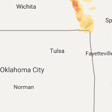
Kansas
| Local Time | Report Details |
|---|---|
| 10:21 PM CDT | At 77 highway near the state line. pulled the hard shell cover of a pickup truck off of the truc in marshall county KS, 54.7 miles N of Manhattan, KS |
| 10:32 PM CDT | Storm damage reported in brown county KS, 75.7 miles NW of Kansas City, MO |
| 10:34 PM CDT | Storm damage reported in marshall county KS, 54.1 miles N of Manhattan, KS |
| 10:35 PM CDT | Numerous 3+ inch diameter tree limbs dow in brown county KS, 72 miles NE of Manhattan, KS |
| 10:40 PM CDT | 2 miles w of hwy 77 and state line 2 to 3 sheds have been completely blown dow in marshall county KS, 57.3 miles NNW of Manhattan, KS |
| 10:46 PM CDT | Estimated 60 to 65 mph wind gusts. numerous tree limbs down... some 2.5 to 3 inches in diameter. minor street flooding also reporte in brown county KS, 72 miles NE of Manhattan, KS |
| 10:47 PM CDT | 70 to 75 mph winds with some gusts possibly up to 80 mph. numerous tree limbs dow in marshall county KS, 54.1 miles N of Manhattan, KS |
| 10:53 PM CDT | Power flashes... no power at their locatio in marshall county KS, 46.5 miles N of Manhattan, KS |
| 10:55 PM CDT | Ping Pong Ball sized hail reported near Morrowville, KS, 62.6 miles NNW of Manhattan, KS |
| 10:55 PM CDT | Storm damage reported in marshall county KS, 47.1 miles N of Manhattan, KS |
| 10:59 PM CDT | Estimated 60 mph winds and heavy rain reported. power was reported out in both home city and marysvill in marshall county KS, 45.7 miles N of Manhattan, KS |
| 11:15 PM CDT | Several 2 to 4 inch diameter tree branches down... with a few 12 foot long branches down. estimated 60 mph wind in marshall county KS, 32.7 miles NNE of Manhattan, KS |
| 11:17 PM CDT | Trees and power lines down in lancaste in atchison county KS, 50.1 miles NW of Kansas City, MO |
| 11:23 PM CDT | Via e in atchison county KS, 50.1 miles NW of Kansas City, MO |
| 11:24 PM CDT | Windows blown out of storm spotter's truck at kingman and 286th rd in atchison county KS, 49.3 miles NW of Kansas City, MO |
| 11:29 PM CDT | Trees uprooted at 274th and phillips rd in atchison county KS, 43.2 miles NW of Kansas City, MO |
| 11:35 PM CDT | Nortonville... k in atchison county KS, 45.6 miles WNW of Kansas City, MO |
| 11:36 PM CDT | Storm damage reported in atchison county KS, 43 miles NW of Kansas City, MO |
| 11:47 PM CDT | Tennis Ball sized hail reported near Washington, KS, 50.5 miles NNW of Manhattan, KS |
| 11:51 PM CDT | At least 70 mph wind gusts at 134th and us 5 in jefferson county KS, 40.7 miles WNW of Kansas City, MO |
| 11:53 PM CDT | 6+ inch tree limbs dow in atchison county KS, 40.5 miles NW of Kansas City, MO |
| 11:54 PM CDT | Estimated 70 mph winds at marshall rd and k-9 in jefferson county KS, 42.6 miles WNW of Kansas City, MO |
| 12:04 AM CDT | Quarter sized hail reported near Greenleaf, KS, 44.4 miles NNW of Manhattan, KS |
| 12:06 AM CDT | Storm damage reported in leavenworth county KS, 30.7 miles WNW of Kansas City, MO |
| 12:13 AM CDT | 55 to 60 mp in leavenworth county KS, 19.8 miles WNW of Kansas City, MO |
| 12:13 AM CDT | 55 to 60 mp in leavenworth county KS, 23 miles NW of Kansas City, MO |
| 12:16 AM CDT | Power lines down just east of baseho in leavenworth county KS, 18.8 miles W of Kansas City, MO |
| 12:17 AM CDT | Baseball sized hail reported near Barnes, KS, 32 miles NNW of Manhattan, KS |
| 12:18 AM CDT | Power lines dow in leavenworth county KS, 20.8 miles WNW of Kansas City, MO |
| 12:21 AM CDT | Via twitter...considerable tree damag in wyandotte county KS, 12.5 miles WNW of Kansas City, MO |
| 12:21 AM CDT | Storm damage reported in wyandotte county KS, 18.3 miles WNW of Kansas City, MO |
| 12:23 AM CDT | At the hollywood casin in wyandotte county KS, 13.3 miles W of Kansas City, MO |
| 12:25 AM CDT | 166th st. and stillwell r in leavenworth county KS, 20.7 miles WSW of Kansas City, MO |
| 12:28 AM CDT | 60 to 70 mph winds at k-32 and cantrell r in leavenworth county KS, 23.5 miles WSW of Kansas City, MO |
| 12:29 AM CDT | Storm damage reported in leavenworth county KS, 19.8 miles WNW of Kansas City, MO |
| 12:38 AM CDT | Storm damage reported in douglas county KS, 38.3 miles WSW of Kansas City, MO |
| 12:40 AM CDT | Near metcalf ave. and i-43 in johnson county KS, 12.8 miles SSW of Kansas City, MO |
| 12:41 AM CDT | Baseball sized hail reported near Randolph, KS, 20.3 miles NNW of Manhattan, KS |
| 12:44 AM CDT | Via twitte in johnson county KS, 10.6 miles SW of Kansas City, MO |
| 12:52 AM CDT | Estimated 60 to 70 mph winds gust in shawnee county KS, 42.4 miles ESE of Manhattan, KS |
| 12:53 AM CDT | 2 inch diameter tree limb dow in shawnee county KS, 42.4 miles ESE of Manhattan, KS |
| 12:53 AM CDT | Storm damage reported in douglas county KS, 43.7 miles WSW of Kansas City, MO |
| 12:56 AM CDT | Quarter sized hail reported near Olsburg, KS, 19.1 miles NNW of Manhattan, KS |
| 12:56 AM CDT | 7 inch diameter tree limb snapped... blocking 2800 blk of sw bingham r in shawnee county KS, 42.9 miles ESE of Manhattan, KS |
| 12:58 AM CDT | 10 inch tree limbs down in 7400 blk sw cannock chase r in shawnee county KS, 42.9 miles ESE of Manhattan, KS |
| 12:58 AM CDT | Large 4 to 5 inch diameter tree branch snapped off a tre in shawnee county KS, 45 miles ESE of Manhattan, KS |
| 1:04 AM CDT | Ixd reported 50 knot in johnson county KS, 25.1 miles SW of Kansas City, MO |
| 1:05 AM CDT | Ixd reported 54 knot in johnson county KS, 25.1 miles SW of Kansas City, MO |
| 2:38 AM CDT | Quarter sized hail reported near Lyndon, KS, 59.5 miles SE of Manhattan, KS |
| 2:46 AM CDT | Golf Ball sized hail reported near Lyndon, KS, 61.6 miles SE of Manhattan, KS |
| 2:50 AM CDT | Golf Ball sized hail reported near Topeka, KS, 38.4 miles ESE of Manhattan, KS |
| 2:57 AM CDT | Fire department dispatced for large tree down in roadway in linn county KS, 53.1 miles NE of Chanute, KS |
| 3:07 AM CDT | Quarter sized hail reported near Auburn, KS, 43.5 miles ESE of Manhattan, KS |
| 3:30 AM CDT | Hen Egg sized hail reported near Osage City, KS, 55.4 miles SE of Manhattan, KS |
| 3:30 AM CDT | Tennis Ball sized hail reported near Osage City, KS, 55.8 miles SE of Manhattan, KS |
| 4:48 AM CDT | Estimated 55 to 65 mph wind in anderson county KS, 27.6 miles NNE of Chanute, KS |
| 5:05 AM CDT | Storm damage reported in allen county KS, 22.5 miles NE of Chanute, KS |
| 5:16 AM CDT | Report of a large four inch tree limb snapped off in 400 block of north crawford in frontena in crawford county KS, 44.5 miles ESE of Chanute, KS |
| 5:30 AM CDT | Power line reported down at teh intersection of us 69 and leighton stree in crawford county KS, 43.8 miles ESE of Chanute, KS |
| 5:32 AM CDT | Large tree was reported down blocking north broadway in the 800 bloc in crawford county KS, 45.1 miles ESE of Chanute, KS |
| 6:39 AM CDT | Storm damage reported in cherokee county KS, 48.8 miles SE of Chanute, KS |
Louisiana
| Local Time | Report Details |
|---|---|
| 12:55 AM CDT | Apache kmis - ms pass 140b awos ne 48 g 55.2 k in gmz555 county LA, 87 miles ESE of New Orleans, LA |
Connect with Interactive Hail Maps