

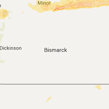
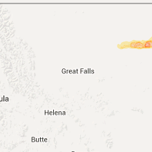
Hail Map for Saturday, June 18, 2016

Number of Impacted Households on 6/18/2016
0
Impacted by 1" or Larger Hail
0
Impacted by 1.75" or Larger Hail
0
Impacted by 2.5" or Larger Hail
Square Miles of Populated Area Impacted on 6/18/2016
0
Impacted by 1" or Larger Hail
0
Impacted by 1.75" or Larger Hail
0
Impacted by 2.5" or Larger Hail


Cities Most Affected by Hail Storms of 6/18/2016
| Hail Size | Demographics of Zip Codes Affected | ||||||
|---|---|---|---|---|---|---|---|
| City | Count | Average | Largest | Pop Density | House Value | Income | Age |
| Wolf Point, MT | 3 | 2.58 | 4.00 | 2 | $52k | $27.0k | 33.4 |
| Glasgow, MT | 3 | 1.92 | 2.00 | 2 | $65k | $32.3k | 45.9 |
| Saco, MT | 2 | 1.88 | 2.00 | 0 | $28k | $23.3k | 48.8 |
| Malta, MT | 1 | 2.00 | 2.00 | 0 | $64k | $31.5k | 46.6 |
| Chinook, MT | 1 | 1.75 | 1.75 | 0 | $63k | $28.3k | 45.6 |
| Poplar, MT | 1 | 1.75 | 1.75 | 0 | $44k | $21.2k | 26.6 |
| Nashua, MT | 1 | 1.75 | 1.75 | 1 | $39k | $26.9k | 51.6 |
Hail and Wind Damage Spotted on 6/18/2016
Filter by Report Type:Hail ReportsWind Reports
Louisiana
| Local Time | Report Details |
|---|---|
| 9:24 AM CDT | 52 knot/60 mph wind gust measured at pilots station east - southwest pass c-man /pstl1/. anemometer height 20.3 meter in plaquemines county LA, 81.2 miles SSE of New Orleans, LA |
| 11:12 AM CDT | Trees down on hwy 126 nw of dodson in winn county LA, 64.7 miles SW of Bastrop, LA |
| 11:12 AM CDT | Trees down nne of dodson on on 499 in winn county LA, 60.2 miles SW of Bastrop, LA |
| 11:12 AM CDT | Trees reported down east of calvin on 501 in winn county LA, 70.8 miles ESE of Shreveport, LA |
| 11:30 AM CDT | Trees reported down in winnfield and trees reported down northern part of paris in winn county LA, 72.8 miles SW of Bastrop, LA |
| 12:03 PM CDT | Trees reported down on i20 north of ada and taylor... mile marker 56 in bienville county LA, 35.1 miles E of Shreveport, LA |
| 12:45 PM CDT | Trees down on 371 with power lines... also franklin road... webster... art camp roads in webster county LA, 28.1 miles E of Shreveport, LA |
| 12:55 PM CDT | Trees down on 371 with power lines... also franklin road... webster... art camp roads in webster county LA, 28.1 miles E of Shreveport, LA |
| 1:30 PM CDT | Rapides 911 reports tree down at forest hil in rapides county LA, 64.5 miles NNW of Lafayette, LA |
| 1:30 PM CDT | Rapides 911 reports tree down at woodwort in rapides county LA, 70.2 miles NNW of Lafayette, LA |
| 1:51 PM CDT | Tree fell on home on greywood drive in keithville in caddo county LA, 8.6 miles S of Shreveport, LA |
| 1:52 PM CDT | Sheriffs dept reports tree down on hwy 1 in vernon county LA, 74.1 miles NW of Lafayette, LA |
| 1:52 PM CDT | Sheriffs dept reports tree down on chaffee r in vernon county LA, 79.8 miles NNE of Beaumont, TX |
| 2:01 PM CDT | Trees and power lines reported down in multiple areas in and near the logansport area in de soto county LA, 40.1 miles SSW of Shreveport, LA |
Alabama
| Local Time | Report Details |
|---|---|
| 12:57 PM CDT | An oak tree was downed across both lanes of the highwa in pike county AL, 69.8 miles SSW of Auburn, AL |
Florida
| Local Time | Report Details |
|---|---|
| 6:06 PM EDT | Power lines have been knocked down at sw 84th ave and bird r in miami-dade county FL, 5.8 miles W of Miami, FL |
| 6:11 PM EDT | A thunderstorm produced a wind gust of 66 mph at marlins park. this was measured at 100 feet above the surfac in miami-dade county FL, 3.5 miles N of Miami, FL |
| 6:12 PM EDT | Fence blown down... near intersection of sw 43rd st and sw 82nd st in miami-dade county FL, 5.8 miles W of Miami, FL |
| 6:13 PM EDT | A thunderstorm wind gust to 56 kts...65 mph was measure in miami-dade county FL, 4.8 miles E of Miami, FL |
Texas
| Local Time | Report Details |
|---|---|
| 5:25 PM CDT | Quarter sized hail reported near Missouri City, TX, 16.6 miles SW of Houston, TX, dime to quarter size hail in missouri city. |
| 7:09 PM CDT | Storm damage reported in harris county TX, 23.3 miles SE of Houston, TX |
| 7:09 PM CDT | 50 knot wind recorded near taylor lake villag in harris county TX, 22.9 miles ESE of Houston, TX |
| 7:30 PM CDT | High island 179a in gmz355 county TX, 65 miles SE of Houston, TX |
| 2:18 AM CDT | Quarter sized hail reported near Childress, TX, 4.8 miles SW of Childress, TX |
| 3:55 AM CDT | Trees down... power lines down... building damage in jackson county TX, 92.9 miles NNE of Corpus Christi, TX |
Oklahoma
| Local Time | Report Details |
|---|---|
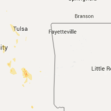
| 6:07 PM CDT | 4 inch tree limb down at 121st and south riverside drive. relayed via social media. time estimated via rada in tulsa county OK, 9 miles S of Tulsa, OK |
| 8:15 PM CDT | Storm damage reported in pontotoc county OK, 37.7 miles NNW of Atoka, OK |
Montana
| Local Time | Report Details |
|---|---|
| 5:49 PM MDT | 62 mph wind gust when the storms moved throug in hill county MT, 30.2 miles N of Havre, MT |
| 6:10 PM MDT | Golf Ball sized hail reported near Chinook, MT, 37.2 miles SE of Havre, MT, quarter to golf ball size hail. window screens broken from hail. time estimated based on radar |
| 6:50 PM MDT | 4 to 6 inch diameter tree limbs down in phillips county MT, 66.1 miles E of Havre, MT |
| 7:00 PM MDT | Estimated wind gusts of 50 to 60 mp in phillips county MT, 69.5 miles ESE of Havre, MT |
| 7:06 PM MDT | Ping Pong Ball sized hail reported near Malta, MT, 70.2 miles W of Glasgow, MT |
| 7:06 PM MDT | Storm damage reported in phillips county MT, 70.2 miles W of Glasgow, MT |
| 7:09 PM MDT | Quarter sized hail reported near Malta, MT, 70.8 miles W of Glasgow, MT, also 70 mph wind and zero visibility. time estimated by radar. |
| 7:10 PM MDT | Hen Egg sized hail reported near Malta, MT, 68.1 miles W of Glasgow, MT |
| 7:17 PM MDT | Trained spotter reported 3 to 5 inch diameter tree branches dow in phillips county MT, 58 miles WNW of Glasgow, MT |
| 7:38 PM MDT | Hen Egg sized hail reported near Saco, MT, 45.6 miles WNW of Glasgow, MT |
| 7:40 PM MDT | Storm damage reported in phillips county MT, 37.9 miles WNW of Glasgow, MT |
| 7:40 PM MDT | Storm damage reported in phillips county MT, 37.9 miles WNW of Glasgow, MT |
| 7:45 PM MDT | Storm damage reported in phillips county MT, 34.3 miles NW of Glasgow, MT |
| 7:45 PM MDT | Very strong winds along with large hail. some of the siding of his house was blown of in phillips county MT, 36.9 miles WNW of Glasgow, MT |
| 7:45 PM MDT | Golf Ball sized hail reported near Saco, MT, 36.9 miles WNW of Glasgow, MT |
| 8:00 PM MDT | Measured by department of transportation sensor mtsco in valley county MT, 35.3 miles WNW of Glasgow, MT |
| 8:15 PM MDT | Hen Egg sized hail reported near Glasgow, MT, 14.2 miles NW of Glasgow, MT, 2 inch hail reported |
| 8:17 PM MDT | Half Dollar sized hail reported near Glasgow, MT, 2.3 miles NW of Glasgow, MT |
| 8:17 PM MDT | Storm damage reported in valley county MT, 2.3 miles NW of Glasgow, MT |
| 8:22 PM MDT | Storm damage reported in valley county MT, 0.4 miles NNW of Glasgow, MT |
| 8:25 PM MDT | Golf Ball sized hail reported near Glasgow, MT, 0.4 miles NNW of Glasgow, MT, golf ball sized hail fell at the glasgow weather office for up to 5 minutes. |
| 8:25 PM MDT | Hen Egg sized hail reported near Glasgow, MT, 2.3 miles NW of Glasgow, MT |
| 8:25 PM MDT | Half Dollar sized hail reported near Glasgow, MT, 0.4 miles NNW of Glasgow, MT |
| 8:30 PM MDT | Golf Ball sized hail reported near Nashua, MT, 7.9 miles ESE of Glasgow, MT |
| 8:30 PM MDT | Storm damage reported in valley county MT, 14.3 miles SE of Glasgow, MT |
| 8:36 PM MDT | Ping Pong Ball sized hail reported near Nashua, MT, 13.8 miles E of Glasgow, MT, 10 broken windows on buildings. time estimated from radar. |
| 8:40 PM MDT | Storm damage reported in valley county MT, 37.8 miles NNE of Glasgow, MT |
| 8:40 PM MDT | Storm damage reported in valley county MT, 37.8 miles NNE of Glasgow, MT |
| 8:40 PM MDT | Half Dollar sized hail reported near Nashua, MT, 13.6 miles ESE of Glasgow, MT |
| 8:50 PM MDT | Estimated by off duty nws employee in valley county MT, 33.4 miles NE of Glasgow, MT |
| 9:00 PM MDT | Ping Pong Ball sized hail reported near Frazer, MT, 29.1 miles ESE of Glasgow, MT |
| 9:15 PM MDT | Golf Ball sized hail reported near Wolf Point, MT, 46.7 miles E of Glasgow, MT |
| 9:20 PM MDT | Grapefruit sized hail reported near Wolf Point, MT, 46.7 miles E of Glasgow, MT |
| 9:23 PM MDT | Storm damage reported in roosevelt county MT, 46.7 miles E of Glasgow, MT |
| 9:25 PM MDT | Ping Pong Ball sized hail reported near Wolf Point, MT, 46.7 miles E of Glasgow, MT |
| 9:25 PM MDT | Hen Egg sized hail reported near Wolf Point, MT, 48.5 miles E of Glasgow, MT |
| 9:31 PM MDT | Measured by mcdonalds dot sensor in roosevelt county MT, 57.5 miles ENE of Glasgow, MT |
| 10:05 PM MDT | Golf Ball sized hail reported near Poplar, MT, 62.6 miles WSW of Williston, ND, also 40 to 50 mph winds |
| 12:05 AM CDT | Crosby raws site. time estimated from rada in divide county ND, 55 miles NNW of Williston, ND |
North Dakota
| Local Time | Report Details |
|---|---|
| 2:23 AM CDT | Quarter sized hail reported near Minot, ND, 0.5 miles SSW of Minot, ND, quarter sized hail in south minot. |
| 2:55 AM CDT | Half Dollar sized hail reported near Towner, ND, 33.1 miles E of Minot, ND, relayed by broadcast media. time estimated from radar. |
| 4:15 AM CDT | Ping Pong Ball sized hail reported near Leeds, ND, 29.6 miles WNW of Devils Lake, ND, hail just smaller than golfball reported. |
| 4:15 AM CDT | Quarter sized hail reported near Leeds, ND, 29.6 miles WNW of Devils Lake, ND, viewer report of one inch hail in leeds reported by local broadcast media |
| 4:40 AM CDT | Quarter sized hail reported near Devils Lake, ND, 13.9 miles NE of Devils Lake, ND, mostly pea sized hail with a few quarter sized hail |
Connect with Interactive Hail Maps