

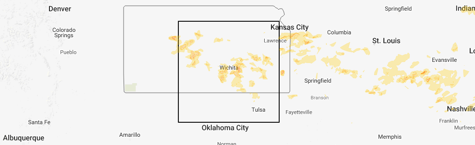
Hail Map for Tuesday, June 26, 2018
Number of Impacted Households on 6/26/2018
0
Impacted by 1" or Larger Hail
0
Impacted by 1.75" or Larger Hail
0
Impacted by 2.5" or Larger Hail
Square Miles of Populated Area Impacted on 6/26/2018
0
Impacted by 1" or Larger Hail
0
Impacted by 1.75" or Larger Hail
0
Impacted by 2.5" or Larger Hail


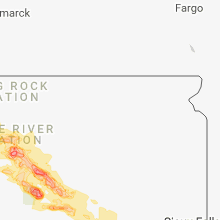


Cities Most Affected by Hail Storms of 6/26/2018
| Hail Size | Demographics of Zip Codes Affected | ||||||
|---|---|---|---|---|---|---|---|
| City | Count | Average | Largest | Pop Density | House Value | Income | Age |
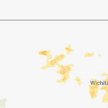
| El Dorado, KS | 3 | 2.33 | 2.75 | 63 | $66k | $35.2k | 35.5 |
| Maize, KS | 1 | 2.50 | 2.50 | 227 | $91k | $52.0k | 30.3 |
| Faith, SD | 1 | 2.50 | 2.50 | 0 | $41k | $23.9k | 39.4 |
| Valley Center, KS | 1 | 2.50 | 2.50 | 96 | $98k | $52.7k | 36.0 |
| Larned, KS | 1 | 2.00 | 2.00 | 16 | $52k | $34.2k | 42.2 |
| Beulah, ND | 1 | 1.75 | 1.75 | 10 | $66k | $43.3k | 45.6 |
| Fredonia, KS | 1 | 1.75 | 1.75 | 16 | $40k | $29.3k | 43.2 |
| Reeder, ND | 1 | 1.75 | 1.75 | 1 | $21k | $24.6k | 49.5 |
| Warrensburg, MO | 1 | 1.75 | 1.75 | 141 | $93k | $33.4k | 26.1 |
| Bowman, ND | 1 | 1.75 | 1.75 | 2 | $59k | $32.9k | 46.8 |
| La Follette, TN | 1 | 1.75 | 1.75 | 127 | $62k | $22.8k | 42.7 |
| Hettinger, ND | 1 | 1.75 | 1.75 | 2 | $42k | $29.8k | 49.3 |
| Great Bend, KS | 1 | 1.75 | 1.75 | 78 | $61k | $33.4k | 38.0 |
Hail and Wind Damage Spotted on 6/26/2018
Filter by Report Type:Hail ReportsWind Reports
States Impacted
Missouri, Kansas, Illinois, Kentucky, Indiana, Virginia, Ohio, North Carolina, South Carolina, Tennessee, Florida, Oklahoma, Alabama, North Dakota, Montana, Georgia, Arkansas, South Dakota, MississippiMissouri
| Local Time | Report Details |
|---|---|
| 7:00 AM CDT | Media report of large limbs down and a tree on a house in ironton. time estimated from rada in iron county MO, 50.3 miles E of Salem, MO |
| 7:20 AM CDT | Report of numerous 6 inch or less diameter tree limbs down and a large tree split in farmingto in st. francois county MO, 58.3 miles NW of Cape Girardeau, MO |
| 1:04 PM CDT | Large healthy tree limbs down. report via social medi in jackson county MO, 12.7 miles SSE of Kansas City, MO |
| 1:06 PM CDT | Large healthy trees split. report via social medi in jackson county MO, 7.8 miles S of Kansas City, MO |
| 1:12 PM CDT | Numerous tree limbs down up to 12 inches in diameter. reported at highway 291 and independence avenue in lees summit m in jackson county MO, 15.5 miles SE of Kansas City, MO |
| 1:12 PM CDT | Numerous tree limbs down up to 12 inches in diameter. reported at highway 291 and independence avenue in lees summit m in jackson county MO, 15.5 miles SE of Kansas City, MO |
| 1:12 PM CDT | Quarter sized hail reported near Sweet Springs, MO, 58.5 miles W of Columbia, MO, most hail around 1/2 inch with bigger stones up to an inch. |
| 1:17 PM CDT | 4 to 6 inch branch split out of healthy hardwood tree. time estimated via rada in cass county MO, 26.7 miles SE of Kansas City, MO |
| 1:18 PM CDT | Reported at cobern road west of highway 7 lake lotawan in jackson county MO, 19.8 miles SE of Kansas City, MO |
| 1:28 PM CDT | Delayed report...several large trees dow in johnson county MO, 35.7 miles ESE of Kansas City, MO |
| 1:30 PM CDT | 6 inch tree limbs broken from thunderstorm wind in johnson county MO, 37.2 miles SE of Kansas City, MO |
| 1:47 PM CDT | Measured at the johnson county em offic in johnson county MO, 51.2 miles ESE of Kansas City, MO |
| 1:53 PM CDT | Several large trees uprooted and down north of warrensbur in johnson county MO, 50.3 miles ESE of Kansas City, MO |
| 1:55 PM CDT | Quarter sized hail reported near Warrensburg, MO, 51.2 miles ESE of Kansas City, MO, at university of central missouri. |
| 1:57 PM CDT | Multiple reports of trees and branches down across portions of johnson county missouri... along with power outage in johnson county MO, 51.2 miles ESE of Kansas City, MO |
| 2:01 PM CDT | Golf Ball sized hail reported near Warrensburg, MO, 51.2 miles ESE of Kansas City, MO |
| 2:05 PM CDT | Outbuilding totally destroye in johnson county MO, 42.3 miles SE of Kansas City, MO |
| 2:06 PM CDT | Large tree limbs dow in johnson county MO, 41.9 miles SE of Kansas City, MO |
| 2:15 PM CDT | Large tree limbs down...blocking a few road in pettis county MO, 51.4 miles WSW of Columbia, MO |
| 2:57 PM CDT | Corrects time for previous tstm wnd dmg report from arcadia. trees down along highway 21. time estimated from rada in iron county MO, 49.8 miles E of Salem, MO |
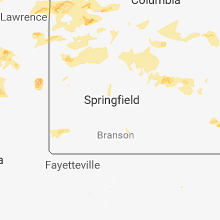
| 3:30 PM CDT | Large trees and power lines snapped about 0.5 mi n of the downtown squar in st. clair county MO, 62 miles NNW of Springfield, MO |
| 3:33 PM CDT | Multiple trees down blocking road in callaway county MO, 24.4 miles SSE of Columbia, MO |
| 3:55 PM CDT | Multiple trees dow in perry county MO, 34.5 miles NNW of Cape Girardeau, MO |
| 3:57 PM CDT | Trees down along highway 21. time estimated from rada in iron county MO, 49.8 miles E of Salem, MO |
| 4:00 PM CDT | Tree limbs down; 3-4" in diameter located about 10 mi e of cross timbers near p highwa in hickory county MO, 57 miles N of Springfield, MO |
| 4:05 PM CDT | Large tree down along highway 19 south of swis in gasconade county MO, 54.7 miles ESE of Columbia, MO |
| 4:10 PM CDT | 4 power poles snappe in jasper county MO, 56.3 miles W of Springfield, MO |
| 4:29 PM CDT | 16 inch diameter tree down on highway 90... about 3 miles west of noel. time estimated by rada in mcdonald county MO, 80.6 miles N of Fort Smith, AR |
| 4:29 PM CDT | Tree downed on a vehicle on hwy 39 and lawrence 2130... south of mt. verno in lawrence county MO, 28.7 miles WSW of Springfield, MO |
| 4:30 PM CDT | 2 large trees and power lines dow in newton county MO, 64.3 miles WSW of Springfield, MO |
| 4:32 PM CDT | 8 inch diameter tree downed on jesse james road in pineville. time estimated by rada in mcdonald county MO, 73.9 miles SW of Springfield, MO |
| 4:35 PM CDT | Trained weather spotter reported a 27" tree down at farm road 136 & highway in greene county MO, 15.9 miles W of Springfield, MO |
| 4:36 PM CDT | Tree blown down blocking traffic at highway 39 and county road 213 in lawrence county MO, 31.9 miles WSW of Springfield, MO |
| 4:37 PM CDT | 16-inch diameter tree blown down on highway 90 west of noe in mcdonald county MO, 80.5 miles N of Fort Smith, AR |
| 4:38 PM CDT | Trees blown ove in pulaski county MO, 49.8 miles WNW of Salem, MO |
| 4:41 PM CDT | Power lines dow in mcdonald county MO, 79.6 miles N of Fort Smith, AR |
| 4:43 PM CDT | 6 inch diameter tree limb downed on n farm road 71. time estimated by rada in greene county MO, 11.7 miles WNW of Springfield, MO |
| 4:47 PM CDT | 67 mph wind gust measured at springfield branson airpor in greene county MO, 6.3 miles WNW of Springfield, MO |
| 4:55 PM CDT | A few small tree limbs down. estimated 50-60 mph gust in greene county MO, 11.1 miles NNW of Springfield, MO |
| 4:55 PM CDT | Signs blown dow in greene county MO, 4.5 miles ENE of Springfield, MO |
| 4:56 PM CDT | Dog pens and carport half destroyed in the 5200 block of highway h. time estimated by rada in polk county MO, 18.7 miles N of Springfield, MO |
| 4:56 PM CDT | Power line downed in the 1300 block of w. phelps st. in springfield. time estimated by rada in greene county MO, 1 miles W of Springfield, MO |
| 5:00 PM CDT | Carport damaged and animal shelter tosse in polk county MO, 17.4 miles N of Springfield, MO |
| 5:00 PM CDT | Carport blown over near the intersections of north campbell avenue and chestnut expresswa in greene county MO, 0.8 miles N of Springfield, MO |
| 5:00 PM CDT | Corrects previous tstm wnd dmg report from 4 ne springfield. signs blown dow in greene county MO, 4.5 miles ENE of Springfield, MO |
| 5:00 PM CDT | Large tree down on w nichols s in greene county MO, 1.7 miles WNW of Springfield, MO |
| 5:35 PM CDT | Numerous tree limbs dow in taney county MO, 39.4 miles S of Springfield, MO |
| 5:35 PM CDT | 2-foot diameter tree down at farm road 128 and f highway. also... a 3-foot diameter tree down at farm roads 25 and 13 in greene county MO, 16.5 miles W of Springfield, MO |
| 5:36 PM CDT | Ping Pong Ball sized hail reported near Van Buren, MO, 52 miles SE of Salem, MO, ping pong ball size hail on the north side of van buren. |
| 5:50 PM CDT | Portion of the roof at the mansfield building supply co was blown off. time estimated by rada in wright county MO, 39.3 miles E of Springfield, MO |
| 5:50 PM CDT | Delayed report...pictures of snapped trees in republic on social medi in greene county MO, 11.6 miles WSW of Springfield, MO |
| 6:40 PM CDT | Several trees were blown down near vanzant. pictures from publi in douglas county MO, 57 miles ESE of Springfield, MO |
| 6:57 PM CDT | Reported at poplar bluff airport in butler county MO, 60.7 miles SW of Cape Girardeau, MO |
| 7:15 PM CDT | Widespread trees and power lines down across the northern part of stoddard county. time estimated by rada in stoddard county MO, 35.5 miles SW of Cape Girardeau, MO |
| 7:15 PM CDT | Large cottonwood tree snapped in poplar bluf in butler county MO, 60.7 miles SW of Cape Girardeau, MO |
| 7:20 PM CDT | Concrete storage shed heavily damaged on north park lane. delayed report. time based on rada in stoddard county MO, 42.2 miles SSW of Cape Girardeau, MO |
| 7:24 PM CDT | Multiple trees down blocking highway 158 two miles east of the junction of us 67 and us 160. delayed report.time estimated by rada in butler county MO, 68.6 miles SW of Cape Girardeau, MO |
| 7:24 PM CDT | Trees and a fence blown down on the north side of poplar bluff. delayed repor in butler county MO, 60.7 miles SW of Cape Girardeau, MO |
| 7:52 PM CDT | Widespread trees and power lines down across the northern part of stoddard count in stoddard county MO, 35.5 miles SW of Cape Girardeau, MO |
| 7:54 PM CDT | Multiple trees down blocking highway 158 two miles east of the junction of us 67 and us 160. delayed repor in butler county MO, 68.6 miles SW of Cape Girardeau, MO |
| 8:01 PM CDT | Concrete storage shed heavily damaged on north park lane. delayed repor in stoddard county MO, 42.2 miles SSW of Cape Girardeau, MO |
Kansas
| Local Time | Report Details |
|---|---|
| 7:34 AM CDT | Half Dollar sized hail reported near Wakeeney, KS, 31.8 miles W of Hays, KS |
| 7:50 AM CDT | Quarter sized hail reported near Bazine, KS, 37.3 miles SW of Hays, KS |
| 8:15 AM CDT | Hen Egg sized hail reported near Larned, KS, 48.3 miles SSE of Hays, KS |
| 8:18 AM CDT | Quarter sized hail reported near Larned, KS, 45.7 miles SSE of Hays, KS |
| 8:29 AM CDT | Quarter sized hail reported near Mc Cracken, KS, 21.2 miles SSW of Hays, KS |
| 8:45 AM CDT | Quarter sized hail reported near Macksville, KS, 65.4 miles SSE of Hays, KS |
| 8:46 AM CDT | Ping Pong Ball sized hail reported near Macksville, KS, 64.5 miles SSE of Hays, KS |
| 8:55 AM CDT | Golf Ball sized hail reported near Great Bend, KS, 48.1 miles SSE of Hays, KS |
| 9:18 AM CDT | Quarter sized hail reported near Victoria, KS, 11.6 miles SE of Hays, KS |
| 12:17 PM CDT | Received a call of 60 to 70 mph winds gusts just west of cedar vale. the wind was strong enough to blow out a window at a local rock quarry where the caller was located in cowley county KS, 58.3 miles SE of Wichita, KS |
| 12:23 PM CDT | Caller estimated 60 to 70 mph wind gusts. time estimated based on rada in chautauqua county KS, 60.8 miles SE of Wichita, KS |
| 12:52 PM CDT | Quarter sized hail reported near Lenexa, KS, 13.2 miles SW of Kansas City, MO, 87th and quivera. |
| 12:58 PM CDT | Quarter sized hail reported near Olathe, KS, 19.3 miles SW of Kansas City, MO |
| 1:33 PM CDT | Estimated winds up to 60mph... numerous tree limbs down and blowing debri in chautauqua county KS, 60.8 miles SE of Wichita, KS |
| 1:42 PM CDT | Storm damage reported in chautauqua county KS, 55.3 miles SW of Chanute, KS |
| 1:42 PM CDT | Tractor trailer blown over on us-166 4 miles west of the cowley/chautauqua county lin in cowley county KS, 55.6 miles SE of Wichita, KS |
| 2:55 PM CDT | Delayed report via twitter... showing a picture of a large section of a tree blown down. time estimated based on rada in neosho county KS, 19.1 miles SE of Chanute, KS |
| 3:26 PM CDT | Tree on car at 31st st. & n michigan ave. in pittsburg; also... power line dow in crawford county KS, 44.5 miles ESE of Chanute, KS |
| 6:35 PM CDT | Quarter size hail reported by potwin fire department. report relayed via local e in butler county KS, 24.5 miles NE of Wichita, KS |
| 6:35 PM CDT | Quarter sized hail reported near Potwin, KS, 24.5 miles NE of Wichita, KS, corrects previous report from potwin. quarter size hail reported by potwin fire department. report relayed via local em. |
| 6:50 PM CDT | Quarter sized hail reported near Burns, KS, 27.9 miles ENE of Wichita, KS |
| 7:02 PM CDT | Butler em estimated 50 to 60 mph winds nw of el dorado. a rotating wall cloud was noted as wel in butler county KS, 26.4 miles ENE of Wichita, KS |
| 7:09 PM CDT | Half Dollar sized hail reported near El Dorado, KS, 27.6 miles ENE of Wichita, KS, weak to moderate rotation noted near spotter's location as well. |
| 7:28 PM CDT | Ping Pong Ball sized hail reported near El Dorado, KS, 27.6 miles ENE of Wichita, KS, ping pong ball size hail reported in el dorado. |
| 7:50 PM CDT | Tennis Ball sized hail reported near El Dorado, KS, 26.1 miles ENE of Wichita, KS, tennis ball size hail reported just west of el dorado. |
| 7:51 PM CDT | Golf Ball sized hail reported near El Dorado, KS, 27.6 miles ENE of Wichita, KS |
| 7:58 PM CDT | Baseball sized hail reported near El Dorado, KS, 27.6 miles ENE of Wichita, KS, butler county em reporting baseball size hail on the nw side of el dorado. |
| 8:08 PM CDT | Half Dollar sized hail reported near Augusta, KS, 15.7 miles E of Wichita, KS, half dollar size hail reported west of augusta. |
| 8:11 PM CDT | Quarter sized hail reported near Augusta, KS, 19.5 miles E of Wichita, KS |
| 8:18 PM CDT | Quarter sized hail reported near Madison, KS, 53.4 miles NW of Chanute, KS, a few quarter size stones. |
| 8:33 PM CDT | Power lines down along highway 77 on the north side of douglas in butler county KS, 19.9 miles ESE of Wichita, KS |
| 8:45 PM CDT | Em relayed report of a destroyed barn and advised that it was likely due to straight-line winds. time estimated via rada in butler county KS, 22.6 miles ESE of Wichita, KS |
| 9:19 PM CDT | 50 to 60 mph wind gusts reported in bentley along with pea to marble size hai in sedgwick county KS, 17.3 miles NW of Wichita, KS |
| 9:30 PM CDT | Quarter sized hail reported near El Dorado, KS, 32.5 miles NE of Wichita, KS, quarter size hail being reported east of hwy 77 north of el dorado. |
| 9:33 PM CDT | Tennis Ball sized hail reported near Valley Center, KS, 8.6 miles NNW of Wichita, KS |
| 9:37 PM CDT | Half Dollar sized hail reported near Maize, KS, 8.5 miles NW of Wichita, KS, twitter report of hail just larger than quarters south of maize. |
| 9:40 PM CDT | Tennis Ball sized hail reported near Maize, KS, 8.9 miles NW of Wichita, KS, estimated via twitter photo. |
| 9:41 PM CDT | Quarter sized hail reported near Colwich, KS, 12.9 miles WNW of Wichita, KS, 60 mph winds accompanied the hail. |
| 9:41 PM CDT | Spotter measured a 62 mph wind gust near colwic in sedgwick county KS, 12.9 miles WNW of Wichita, KS |
| 10:11 PM CDT | Half Dollar sized hail reported near Garden Plain, KS, 21.7 miles W of Wichita, KS, quarter to half dollar size hail being reported at 21st and 334th. |
| 10:27 PM CDT | Reported by campers at lake afton. ping-pong ball size hail accompanied the win in sedgwick county KS, 17 miles WSW of Wichita, KS |
| 10:27 PM CDT | Ping Pong Ball sized hail reported near Goddard, KS, 17 miles WSW of Wichita, KS, ping pong ball size hail reported near lake afton. time estimated via radar. |
| 10:40 PM CDT | Quarter sized hail reported near Clearwater, KS, 13 miles SW of Wichita, KS |
| 10:50 PM CDT | A tree was reported downed in fredonia. wind speeds unknow in wilson county KS, 22.8 miles WSW of Chanute, KS |
| 10:50 PM CDT | Golf Ball sized hail reported near Fredonia, KS, 22.5 miles WSW of Chanute, KS, delayed report. mostly nickel to quarter size... with a few golfballs mixed in. |
| 11:00 PM CDT | Nickel size hail accompanied the win in sedgwick county KS, 22 miles SW of Wichita, KS |
| 11:01 PM CDT | Storm damage reported in sumner county KS, 22.1 miles SW of Wichita, KS |
| 11:18 PM CDT | Quarter sized hail reported near Conway Springs, KS, 22.9 miles SW of Wichita, KS |
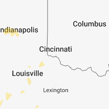
Illinois
| Local Time | Report Details |
|---|---|
| 8:25 AM CDT | Trees down in the communit in saline county IL, 61.1 miles NE of Cape Girardeau, MO |
| 9:28 AM CDT | Trees blocking north line street in the communit in williamson county IL, 44.5 miles ENE of Cape Girardeau, MO |
| 9:28 AM CDT | Trees down in different areas of the communit in saline county IL, 56.3 miles WSW of Evansville, IN |
| 9:30 AM CDT | Trees down in the communit in franklin county IL, 61.1 miles NE of Cape Girardeau, MO |
| 9:35 AM CDT | Pole and line down along second stree in gallatin county IL, 40.6 miles W of Evansville, IN |
| 9:45 AM CDT | Tree dow in hamilton county IL, 49 miles W of Evansville, IN |
| 9:50 AM CDT | Trees down along highway 1 in white county IL, 41.9 miles W of Evansville, IN |
| 9:55 AM CDT | Trees and power lines down along highway 1 in hardin county IL, 48.2 miles SW of Evansville, IN |
| 3:14 PM CDT | Large tree blown down partially blocking route 47 approximately 1.5 miles south of route 20. other small tree limbs blown dow in kane county IL, 42.8 miles WNW of Chicago, IL |
| 4:45 PM CDT | Tree blocking old us 51 south near raccoon valley roa in jackson county IL, 27.6 miles NE of Cape Girardeau, MO |
| 4:45 PM CDT | Eight inch tree limbs down. chimney damage to a hous in jackson county IL, 31.5 miles NE of Cape Girardeau, MO |
| 5:37 PM CDT | 24-inch diameter tree blown down in valmeyer... il. time estimated from rada in monroe county IL, 22.2 miles S of Saint Louis, MO |
| 5:43 PM CDT | Trees down blocking both lanes of highway 4 in saline county IL, 56.3 miles ENE of Cape Girardeau, MO |
| 5:53 PM CDT | Power lines down on highway 3 in pope county IL, 55.2 miles WSW of Evansville, IN |
| 6:58 PM CDT | Small parts of a roof removed and several trees down on the south side of manhattan. wires also down on bruns road and route 52. possible tornado. report relayed via tw in will county IL, 37.3 miles SSW of Chicago, IL |
Kentucky
| Local Time | Report Details |
|---|---|
| 10:00 AM EDT | Power line down on white oak road. extremely high water in area as wel in boyle county KY, 47.2 miles W of Irvine, KY |
| 10:10 AM EDT | Power line down...reported at woodlawn rd and spencer mattingly nelson county k in nelson county KY, 19.5 miles SE of Louisville, KY |
| 10:42 AM EDT | Storm damage reported in taylor county KY, 48.4 miles SSE of Louisville, KY |
| 10:43 AM EDT | Multiple trees down across kentucky highway 69 in perry county KY, 59.6 miles NW of Bristol, TN |
| 10:15 AM CDT | Reported via kentucky mesonet in crittenden county KY, 52.1 miles SW of Evansville, IN |
| 11:31 AM EDT | Tree down versailles r in franklin county KY, 50.5 miles ENE of Louisville, KY |
| 10:43 AM CDT | Tree limbs down and blown power transforme in henderson county KY, 9.5 miles S of Evansville, IN |
| 11:04 AM CDT | Numerous trees damaged with wind gusts estimated 40 to 50 mp in trigg county KY, 61.9 miles NE of Mc Kenzie, TN |
| 11:05 AM CDT | Large tree snapped with widespread tree limbs down. winds estimated 50 to 60 mp in daviess county KY, 21.2 miles ESE of Evansville, IN |
| 11:13 AM CDT | Several trees dow in edmonson county KY, 64.4 miles SW of Louisville, KY |
| 11:13 AM CDT | Several trees dow in edmonson county KY, 67.2 miles SSW of Louisville, KY |
| 11:13 AM CDT | Semi tractor blown on west side of community at the tractor supply stor in daviess county KY, 28.5 miles ESE of Evansville, IN |
| 11:45 AM CDT | Corrects previous tstm wnd dmg report from 4 s union star. tree down 7 n of hardinsburg area of ky 227 in breckinridge county KY, 40.7 miles W of Louisville, KY |
| 11:49 AM CDT | Tree down on state road 319 in breckinridge county KY, 50.4 miles ESE of Evansville, IN |
| 11:53 AM CDT | Tree fell on power lines on state road 73 in breckinridge county KY, 45.5 miles SW of Louisville, KY |
| 11:53 AM CDT | Tree down on state road 25 in breckinridge county KY, 46.5 miles SW of Louisville, KY |
| 11:54 AM CDT | Building under construction (just the frame) was flattened. trees were also reported down in the central/northern part of the count in breckinridge county KY, 41.3 miles WSW of Louisville, KY |
| 11:59 AM CDT | A tree fell on the corner of a house in harne in breckinridge county KY, 41.3 miles WSW of Louisville, KY |
| 12:01 PM CDT | Tree down on s state road 33 in breckinridge county KY, 30.6 miles WSW of Louisville, KY |
| 12:03 PM CDT | Corrects previous tstm wnd dmg report from 4 nnw hudson. tree down on power lines on state road 107 in breckinridge county KY, 38.5 miles WSW of Louisville, KY |
| 12:03 PM CDT | Corrects time from previous tstm wnd dmg report from 2 e roundhill. several trees dow in edmonson county KY, 64.4 miles SW of Louisville, KY |
| 12:20 PM CDT | Corrects time from previous tstm wnd dmg report from 3 n hays. several trees dow in edmonson county KY, 67.2 miles SSW of Louisville, KY |
| 12:25 PM CDT | Tree down 7 n of hardinsburg area of ky 227 in breckinridge county KY, 40.7 miles W of Louisville, KY |
| 1:30 PM EDT | Large tree fell on power line near residenc in jefferson county KY, 18.1 miles N of Louisville, KY |
| 1:33 PM EDT | Reported at bowman field louisville k in jefferson county KY, 16.2 miles N of Louisville, KY |
| 1:36 PM EDT | Private business agc automotive americas had mechanical units blown off roof and metal wall panels blown approximately 1000-1500 ft downwin in hardin county KY, 24.6 miles SSW of Louisville, KY |
| 1:42 PM EDT | Large limbs down along rollington rd in jefferson county and into oldham county... picnic table in middle of main roa in jefferson county KY, 24.9 miles NNE of Louisville, KY |
| 1:42 PM EDT | Tree down on roof; much siding removed from at least two home in jefferson county KY, 24.7 miles NNE of Louisville, KY |
| 1:42 PM EDT | Trees down over railroad track in jefferson county KY, 23.7 miles NNE of Louisville, KY |
| 1:48 PM EDT | Tress down across railroa in jefferson county KY, 23.7 miles NNE of Louisville, KY |
| 12:50 PM CDT | Trees reported down at franklin rd and chapel hill rd scottsville... k in allen county KY, 46.5 miles NE of Nashville, TN |
| 1:56 PM EDT | 1 tree had to be removed from oak tree way... and 1 tree had to be removed from elk creek roa in spencer county KY, 19.1 miles E of Louisville, KY |
| 1:58 PM EDT | Tree down across roa in laurel county KY, 43.7 miles SSW of Irvine, KY |
| 1:03 PM CDT | Multiple trees down countywide... some blocking roads. also... some side roads are covered with water as some small creeks/streams have overflow in green county KY, 51.6 miles SSE of Louisville, KY |
| 2:10 PM EDT | Multiple trees reported down at lagrange rd new castle... k in henry county KY, 42.4 miles NE of Louisville, KY |
| 2:10 PM EDT | Multiple trees reported down at east cross main st new castle... k in henry county KY, 43 miles NE of Louisville, KY |
| 2:11 PM EDT | Tree down near mm39... i-71 blocking right lan in carroll county KY, 41.9 miles SW of Cincinnati, OH |
| 2:15 PM EDT | Multiple trees reported down at point pleasant rd new castle... k in henry county KY, 44 miles NE of Louisville, KY |
| 2:16 PM EDT | Tree down on east lovers lane near us 6 in marion county KY, 40.1 miles SE of Louisville, KY |
| 2:20 PM EDT | Tree down on fisher creek roa in marion county KY, 45.7 miles SE of Louisville, KY |
| 2:23 PM EDT | Several trees downed along ky-35 in owen county KY, 50.1 miles SSW of Cincinnati, OH |
| 2:27 PM EDT | Several trees downed along ky-35 in owen county KY, 51.3 miles SSW of Cincinnati, OH |
| 2:36 PM EDT | 58 mph recorded on bluegrass pkwy with calibrated equipmen in anderson county KY, 46.2 miles E of Louisville, KY |
| 2:40 PM EDT | Several trees down in hustonvill in lincoln county KY, 49 miles WSW of Irvine, KY |
| 1:42 PM CDT | Trees reported dow in cumberland county KY, 84.8 miles SSE of Louisville, KY |
| 1:52 PM CDT | Trees dow in monroe county KY, 64.5 miles ENE of Nashville, TN |
| 3:06 PM EDT | Tree down on hwy 9 in whitley county KY, 54.7 miles N of Knoxville, TN |
| 3:07 PM EDT | Small building blown off foundation with debris blown approximately 800 feet downwin in hardin county KY, 24.8 miles SSW of Louisville, KY |
| 3:09 PM EDT | One tree downed on ky-18 near botts lan in boone county KY, 17.2 miles WSW of Cincinnati, OH |
| 3:14 PM EDT | Tree reported down on bastin creek roa in casey county KY, 51.4 miles WSW of Irvine, KY |
| 3:14 PM EDT | Tree reported down on hurricane ridge roa in casey county KY, 51.3 miles WSW of Irvine, KY |
| 3:30 PM EDT | Many trees (several snapped off 1/2 to 3/4 of the way up) and limbs down. several trees have fallen on top of power line in jefferson county KY, 24.1 miles NNE of Louisville, KY |
| 3:40 PM EDT | Power down from trees in many parts of louisville. time earlier in da in jefferson county KY, 18.2 miles N of Louisville, KY |
| 3:41 PM EDT | Structural damage reported at westport road louisville... ky. time earlier in da in jefferson county KY, 24.1 miles NNE of Louisville, KY |
| 3:55 PM EDT | Tree down on intersection of hwy 26 and new zion roa in whitley county KY, 58.4 miles NNW of Knoxville, TN |
| 6:48 PM CDT | 6 to 10 trees down along us highway 41a in henderson county KY, 12.4 miles S of Evansville, IN |
| 7:10 PM CDT | Trees uprooted. relayed via faceboo in daviess county KY, 24.3 miles SE of Evansville, IN |
| 7:20 PM CDT | Numerous trees down... one fell across a mobile hom in muhlenberg county KY, 46.5 miles SSE of Evansville, IN |
| 7:25 PM CDT | Widespread trees downs throughout the communit in muhlenberg county KY, 52.4 miles SSE of Evansville, IN |
| 7:29 PM CDT | Tree fell on a car. injuries reporte in henderson county KY, 19 miles SSW of Evansville, IN |
| 7:29 PM CDT | Large tree limbs dow in henderson county KY, 16.9 miles SE of Evansville, IN |
| 8:45 PM CDT | Tree down across butterworth road west of murray. delayed repor in calloway county KY, 33.5 miles N of Mc Kenzie, TN |
| 9:17 PM CDT | *** 1 inj *** tree fell on a moving car on airport road. one person injure in calloway county KY, 36.2 miles NNE of Mc Kenzie, TN |
Indiana
| Local Time | Report Details |
|---|---|
| 10:10 AM CDT | Widespread tree damage along interstate 64 near the black river rest are in posey county IN, 17.8 miles NW of Evansville, IN |
| 10:10 AM CDT | Numerous trees and power lines down. isolated power outages reporte in posey county IN, 23.9 miles WSW of Evansville, IN |
| 10:23 AM CDT | Hundreds of trees and power lines down through much of the city. widespread power outages. gutter and shingle damage on two homes. semi rolled over. damage occurred on in gibson county IN, 18.8 miles N of Evansville, IN |
| 10:23 AM CDT | Trees and power lines down along coal mine roa in gibson county IN, 16.8 miles N of Evansville, IN |
| 10:38 AM CDT | Tree limbs down and power outages reported on the nnw side of tow in vanderburgh county IN, 1.3 miles E of Evansville, IN |
| 10:43 AM CDT | Winds estimated 50 to 60 mph in the subdivision of angel mound in vanderburgh county IN, 1.3 miles E of Evansville, IN |
| 11:52 AM EDT | Trees and power and lines dow in pike county IN, 33.8 miles NE of Evansville, IN |
| 12:00 PM EDT | Large walnut tree uprooted reported at 206 s 6th st holland... i in dubois county IN, 34.2 miles ENE of Evansville, IN |
| 12:06 PM EDT | Power lines down in huntingburg and duff area in dubois county IN, 39.7 miles NE of Evansville, IN |
| 12:10 PM EDT | Corrects time from previous tstm wnd dmg report from huntingburg. power outage in huntingburg... in are in dubois county IN, 39.7 miles NE of Evansville, IN |
| 12:12 PM EDT | Large tree reported down at lechner ln and 2nd st jasper... i in dubois county IN, 43.5 miles NE of Evansville, IN |
| 12:25 PM EDT | Numerous trees reported down. time estimated from rada in martin county IN, 63.7 miles NE of Evansville, IN |
| 12:30 PM EDT | Storm damage reported in dubois county IN, 52.4 miles ENE of Evansville, IN |
| 12:30 PM EDT | Power outage in huntingburg... in are in dubois county IN, 39.7 miles NE of Evansville, IN |
| 12:45 PM EDT | Trees dow in pike county IN, 41.6 miles NE of Evansville, IN |
| 12:50 PM EDT | Bradford pear type of tree blown down along driveway between mcintosh road and magnolia road on the west side of state road 6 in crawford county IN, 39.6 miles WNW of Louisville, KY |
| 12:51 PM EDT | A one mile wide swath of tree damage running north and south just west of state road 66 near hillcrest driv in crawford county IN, 40 miles WNW of Louisville, KY |
| 12:54 PM EDT | 2 locations over west central part of the county with trees down. time estimated from rada in lawrence county IN, 71 miles NW of Louisville, KY |
| 1:00 PM EDT | Two trees down on homes in scottsburg... i in scott county IN, 48.6 miles N of Louisville, KY |
| 1:00 PM EDT | Trees down along highway 5 in scott county IN, 48.4 miles N of Louisville, KY |
| 1:05 PM EDT | Bradford pear type tree broke in half with upper half blocking southbound edsel lane at federal driv in harrison county IN, 28 miles NW of Louisville, KY |
| 1:05 PM EDT | Bradford pear type tree broke in half with upper half blocking southbound edsel lane at federal driv in harrison county IN, 28 miles NW of Louisville, KY |
| 1:05 PM EDT | Bradford pear type tree broke in half with upper half blocking southbound edsel lane at federal driv in harrison county IN, 28 miles NW of Louisville, KY |
| 3:02 PM EDT | One tree downed on nelson roa in ohio county IN, 22.1 miles WSW of Cincinnati, OH |
| 7:18 PM CDT | Multiple trees down in evansville. a tree fell on a house on the west side of evansvill in vanderburgh county IN, 1.3 miles E of Evansville, IN |
Virginia
| Local Time | Report Details |
|---|---|
| 11:20 AM EDT | Several trees down in wis in wise county VA, 33.3 miles NW of Bristol, TN |
Ohio
| Local Time | Report Details |
|---|---|
| 1:39 PM EDT | 1 inch tree limbs broken... shingles blown off. time estimated from radar dat in montgomery county OH, 46.4 miles NNE of Cincinnati, OH |
| 1:52 PM EDT | 3 inch limbs blown down... power pole damage. time estimated from radar dat in greene county OH, 52.3 miles NNE of Cincinnati, OH |
North Carolina
| Local Time | Report Details |
|---|---|
| 2:30 PM EDT | 911 call center reported multiple trees down in mills river. time estimated from rada in henderson county NC, 38.6 miles N of Greenville, SC |
| 2:40 PM EDT | 911 call center reported multiple trees down in fletcher. time estimated from rada in henderson county NC, 41.7 miles N of Greenville, SC |
| 3:15 PM EDT | Amateur radio reported a tree down on pond rd. time estimated from rada in buncombe county NC, 48.9 miles N of Greenville, SC |
| 3:35 PM EDT | 911 call center reported multiple trees down on west st south main st and north main st in rutherfordto in rutherford county NC, 51.9 miles NE of Greenville, SC |
| 4:15 PM EDT | 911 call center reported numerous trees and power lines down in the henrietta and cliffside areas. time estimated from rada in rutherford county NC, 53.4 miles ENE of Greenville, SC |
| 4:34 PM EDT | Tree down on power lines and on fire on ford s in cleveland county NC, 40.1 miles W of Charlotte, NC |
| 4:35 PM EDT | Power line down on west marion st. time estimated from rada in cleveland county NC, 40.6 miles W of Charlotte, NC |
| 4:35 PM EDT | Power line down on west marion st. time estimated from rada in cleveland county NC, 40.6 miles W of Charlotte, NC |
| 4:35 PM EDT | Power line down at mcgowan rd and gidney st. time estimated from rada in cleveland county NC, 39.4 miles W of Charlotte, NC |
| 4:39 PM EDT | Tree down on south dekalb st. in shelb in cleveland county NC, 39.9 miles W of Charlotte, NC |
| 6:30 PM EDT | 911 call center reported numerous trees down in the county. time estimated from rada in swain county NC, 45.2 miles SE of Knoxville, TN |
| 6:37 PM EDT | 911 call center reported numerous trees down in the northern part of haywood county. time estimated from rada in haywood county NC, 59.4 miles ESE of Knoxville, TN |
| 6:40 PM EDT | 911 call center reported numerous trees down in the northern part of the county. time estimated from rada in haywood county NC, 56.5 miles ESE of Knoxville, TN |
| 6:50 PM EDT | 911 call center reported numerous trees and power lines down across the county. time estimated from rada in macon county NC, 53.8 miles SSE of Knoxville, TN |
| 7:11 PM EDT | 911 call center reported numerous trees down on leicester highway. time estimated from rada in buncombe county NC, 57.4 miles N of Greenville, SC |
| 7:11 PM EDT | 911 call center reported a tree on a house in candler. numerous trees and power lines dow in buncombe county NC, 49.8 miles N of Greenville, SC |
South Carolina
| Local Time | Report Details |
|---|---|
| 3:00 PM EDT | 911 call center reported numerous trees down in the salem area. time estimated from rada in oconee county SC, 22 miles W of Greenville, SC |
| 3:00 PM EDT | 911 call center reported numerous trees and powerlines down in northern pickens count in pickens county SC, 12 miles NNW of Greenville, SC |
| 3:20 PM EDT | 911 call center reported numerous trees down near the salem area. time estimated from rada in oconee county SC, 21.7 miles W of Greenville, SC |
| 3:30 PM EDT | 911 call center reported numerous trees and power lines down in eastern pickens county. time estimated from rada in pickens county SC, 3.4 miles N of Greenville, SC |
| 3:45 PM EDT | Schp reported a tree down at williams rd and st mark rd in greenville county SC, 18.6 miles ENE of Greenville, SC |
| 3:50 PM EDT | Schp reported power lines down at locust hill rd and w mcelhaney rd in greenville county SC, 18.7 miles ENE of Greenville, SC |
| 3:50 PM EDT | Schp reported a tree down at on riveroak rd in spartanburg county SC, 38.8 miles ENE of Greenville, SC |
| 4:52 PM EDT | 911 call center reported many trees down in the york area. time estimated from rada in york county SC, 27.9 miles SW of Charlotte, NC |
| 5:03 PM EDT | Schp reported a tree down at anderson mill rd and smith ct in spartanburg county SC, 33.9 miles E of Greenville, SC |
| 5:05 PM EDT | 911 call center reported several trees down in southern spartanburg county. time estimated from rada in spartanburg county SC, 38.4 miles ENE of Greenville, SC |
| 5:34 PM EDT | Quarter sized hail reported near Laurens, SC, 38.3 miles SE of Greenville, SC, public reported quarter (1.00 in) size hail on ekom beach rd. time estimated from radar. |
| 5:40 PM EDT | 911 call center reported a tree down in jonesville. time estimated from rada in union county SC, 52.3 miles E of Greenville, SC |
| 6:15 PM EDT | 911 call center reported 3 power lines and 7 trees down in the calhoun falls area. time estimated from rada in abbeville county SC, 51.1 miles S of Greenville, SC |
| 6:50 PM EDT | One tree was downed on columbia rd in winnsbor in fairfield county SC, 61.2 miles SSW of Charlotte, NC |
| 7:04 PM EDT | Sc highway patrol reported a tree in the roadway on interstate 26 at mile marker 8 in lexington county SC, 61.3 miles NE of Augusta, GA |
| 7:05 PM EDT | Schp reported tree down on interstate 26 at mile marker 9 in lexington county SC, 61.3 miles NE of Augusta, GA |
| 7:10 PM EDT | Tree down on smith pond r in lexington county SC, 50.3 miles NE of Augusta, GA |
| 7:11 PM EDT | Tree down on living inn r in newberry county SC, 52.2 miles NE of Augusta, GA |
| 7:16 PM EDT | Tree down on roadway... 200 beekeeper c in lexington county SC, 57.7 miles NE of Augusta, GA |
| 7:16 PM EDT | Numerous trees down in the town of mccormic in mccormick county SC, 34.8 miles NNW of Augusta, GA |
| 7:20 PM EDT | Tree down... also taking down power lines... on kingsbridge r in lexington county SC, 62.1 miles NE of Augusta, GA |
| 7:50 PM EDT | Trees down in the parksville are in mccormick county SC, 25.7 miles NNW of Augusta, GA |
| 9:07 PM EDT | Trees and power lines down on forest drive in aiken... sc. photo submitted through social medi in aiken county SC, 14.4 miles ENE of Augusta, GA |
| 9:17 PM EDT | Sc highway patrol reported a tree blocking the roadway at new bridge road and joyce branch roa in aiken county SC, 21.6 miles ENE of Augusta, GA |
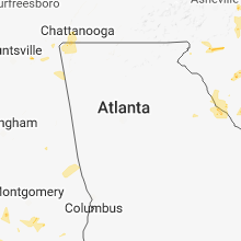
Tennessee
| Local Time | Report Details |
|---|---|
| 2:30 PM CDT | Tree down at 1750 parker road in pickett county TN, 77.9 miles NW of Knoxville, TN |
| 4:05 PM EDT | Couple trees dow in grainger county TN, 44.4 miles NE of Knoxville, TN |
| 4:10 PM EDT | Golf Ball sized hail reported near La Follette, TN, 30.6 miles NNW of Knoxville, TN |
| 4:20 PM EDT | Quarter sized hail reported near Knoxville, TN, 1.8 miles WNW of Knoxville, TN, reported at different locations across knoxville. |
| 4:20 PM EDT | Quarter sized hail reported near Russellville, TN, 45.3 miles ENE of Knoxville, TN |
| 4:25 PM EDT | Several trees dow in hamblen county TN, 48.1 miles ENE of Knoxville, TN |
| 4:30 PM EDT | Several trees dow in campbell county TN, 31.8 miles NNW of Knoxville, TN |
| 4:40 PM EDT | Several trees dow in morgan county TN, 38.7 miles WNW of Knoxville, TN |
| 4:45 PM EDT | Numerous trees down...mainly across the eastern and northeastern portions of the count in union county TN, 26.9 miles NNE of Knoxville, TN |
| 4:55 PM EDT | One large tree down in knox county TN, 8.3 miles N of Knoxville, TN |
| 5:15 PM EDT | Several trees dow in knox county TN, 1.8 miles WNW of Knoxville, TN |
| 5:20 PM EDT | Several trees dow in roane county TN, 35.9 miles W of Knoxville, TN |
| 5:20 PM EDT | Quarter sized hail reported near Knoxville, TN, 1.8 miles WNW of Knoxville, TN, reported at different locations across knoxville. |
| 5:30 PM EDT | Few trees dow in greene county TN, 54.7 miles SW of Bristol, TN |
| 5:40 PM EDT | Several trees dow in sevier county TN, 19.7 miles ESE of Knoxville, TN |
| 5:45 PM EDT | Couple trees dow in loudon county TN, 22.5 miles WSW of Knoxville, TN |
| 5:50 PM EDT | A few trees dow in loudon county TN, 29 miles WSW of Knoxville, TN |
| 5:55 PM EDT | Several trees dow in rhea county TN, 51.1 miles NNE of Chattanooga, TN |
| 6:35 PM EDT | Trees and powerlines dow in mcminn county TN, 48.8 miles NE of Chattanooga, TN |
| 8:10 PM EDT | Small tree on home in hamilton county TN, 5.1 miles SE of Chattanooga, TN |
Florida
| Local Time | Report Details |
|---|---|
| 4:00 PM EDT | Report via social media of a tree down on highway 22 in taylor county FL, 44.2 miles ESE of Tallahassee, FL |
| 4:01 PM EDT | Tree across southbound lane of us-27 near the rest area. time estimated by rada in taylor county FL, 37.1 miles ESE of Tallahassee, FL |
| 3:48 PM CDT | Tree down in the sunny hills communit in washington county FL, 45.2 miles ENE of Miramar Beach, FL |
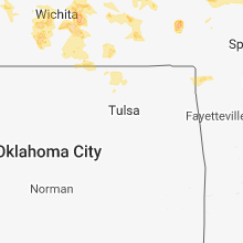
Oklahoma
| Local Time | Report Details |
|---|---|
| 3:00 PM CDT | 2 power poles blown over. power outages reported in dewe in washington county OK, 44.9 miles N of Tulsa, OK |
| 3:25 PM CDT | Storm damage reported in nowata county OK, 46.8 miles NNE of Tulsa, OK |
| 3:45 PM CDT | Multiple reports of trees dow in mayes county OK, 50.2 miles ENE of Tulsa, OK |
| 3:54 PM CDT | Tree through the roof of a cabi in mayes county OK, 59.4 miles ENE of Tulsa, OK |
Alabama
| Local Time | Report Details |
|---|---|
| 4:00 PM CDT | Tree fell onto a house along marshall street. no injuries reported. time estimated from radar... and showed non-severe winds. kalx gusted to 22 mp in tallapoosa county AL, 35.6 miles NW of Auburn, AL |
| 4:00 PM CDT | Tree fell onto a house and power lines along hillabee street. no injuries reported. time estimated from radar... and showed non-severe winds. kalx gusted to 22 mp in tallapoosa county AL, 35.2 miles NW of Auburn, AL |
North Dakota
| Local Time | Report Details |
|---|---|
| 4:55 PM CDT | Quarter sized hail reported near Tolley, ND, 47.7 miles NNW of Minot, ND, hail lasted about 5 minutes until 500 pm. also had 2.10 inches of rain from two storms that moved through in the past hour. some water standing in driveway and low spot |
| 4:55 PM CDT | Quarter sized hail reported near Mohall, ND, 43.6 miles NNW of Minot, ND, hail lasted about 10 minutes until 505 pm. also had wind as high as 50 mph and 1.08 inches of rain 15 minutes. |
| 5:53 PM MDT | Ping Pong Ball sized hail reported near Bowman, ND, 120.9 miles E of Miles City, MT, no damage reported. hail lasted several minutes but no exact length of time. |
| 6:12 PM MDT | Quarter sized hail reported near Dickinson, ND, 95.5 miles W of Bismarck, ND |
| 7:15 PM CDT | Quarter sized hail reported near Burlington, ND, 8.7 miles W of Minot, ND |
| 6:46 PM MDT | Quarter sized hail reported near Bowman, ND, 119.2 miles E of Miles City, MT, hail continues at time this report sent... along highway 85. |
| 6:48 PM MDT | Golf Ball sized hail reported near Bowman, ND, 118.9 miles E of Miles City, MT, public report to tv social media page. no duration nor report of damage. report relayed by broadcast meteorologist. |
| 6:50 PM MDT | Quarter sized hail reported near Richardton, ND, 74.6 miles WNW of Bismarck, ND |
| 7:20 PM MDT | Storm damage reported in adams county ND, 114.2 miles WSW of Bismarck, ND |
| 8:36 PM CDT | Tree branches dow in morton county ND, 60.6 miles W of Bismarck, ND |
| 7:45 PM MDT | Half Dollar sized hail reported near Hettinger, ND, 104.9 miles WSW of Bismarck, ND, adams county law enforcement report. drove nd highway 8 from hettinger to the south dakota border. had half dollar size hail in hettinger... near airport... and half do |
| 8:50 PM CDT | Quarter sized hail reported near Glen Ullin, ND, 50.9 miles WNW of Bismarck, ND |
| 7:53 PM MDT | Quarter sized hail reported near Hettinger, ND, 104.9 miles WSW of Bismarck, ND, still ongoing at the time this report was sent. |
| 8:55 PM CDT | Corrects previous non-tstm wnd gst report from glen ullin rgnl. awos station d57... glen ullin rgn in morton county ND, 51.3 miles W of Bismarck, ND |
| 8:56 PM CDT | Several large trees and numerous branches downed in the town of glen ullin. law enforcement estimated 70 mph wind in morton county ND, 49.9 miles W of Bismarck, ND |
| 8:00 PM MDT | Golf Ball sized hail reported near Beulah, ND, 58.7 miles NW of Bismarck, ND |
| 10:25 PM MDT | Golf Ball sized hail reported near Reeder, ND, 114.2 miles WSW of Bismarck, ND, 60 mph winds also breaking branches. hail still ongoing at time of call. the duration of the hail event was 10 minutes. |
| 10:48 PM MDT | Quarter sized hail reported near Hettinger, ND, 104.5 miles WSW of Bismarck, ND, quarter sized hail began at 1148 pm cdt nd lasted 5 minutes. still hailing at the time of the report. |
| 11:00 PM MDT | Golf Ball sized hail reported near Hettinger, ND, 104.9 miles WSW of Bismarck, ND, largest hail was 1.75 inches. lots of ping pong ball sized hail covering the ground. broken windows. the duration of the hail event was 20 minutes. |
Montana
| Local Time | Report Details |
|---|---|
| 4:47 PM MDT | Quarter sized hail reported near Columbus, MT, 38.2 miles WSW of Billings, MT |
Georgia
| Local Time | Report Details |
|---|---|
| 8:05 PM EDT | *** 3 inj *** 3 people were injured when a barn they were performing maintenance on collapsed as the gust front preceding a broken line of thunderstorms moved through t in catoosa county GA, 17.5 miles ESE of Chattanooga, TN |
| 8:25 PM EDT | Emergency manager reports multiple trees down at duncan bridge rd and hwy 255 south in white county GA, 63.3 miles WSW of Greenville, SC |
| 8:40 PM EDT | Reports of a tree blown down near new home loop and ivey rd in northern dade county in dade county GA, 15.2 miles WSW of Chattanooga, TN |
| 8:40 PM EDT | Tree blown down in chickamauga in walker county GA, 10.8 miles S of Chattanooga, TN |
| 8:40 PM EDT | Tree blown down in lookout mountain... ga in walker county GA, 6 miles SSW of Chattanooga, TN |
| 8:40 PM EDT | Tree blown down in rossville in walker county GA, 5.5 miles SSE of Chattanooga, TN |
| 8:50 PM EDT | Reports of a tree blown down on burkhalter gap rd... ne of trenton in dade county GA, 13.4 miles SW of Chattanooga, TN |
| 8:53 PM EDT | 911 call center reported a tree down on dixon rd and state hwy 105. time estimated from rada in habersham county GA, 60.4 miles WSW of Greenville, SC |
| 9:15 PM EDT | Tree blow down in lafayette in walker county GA, 23.2 miles S of Chattanooga, TN |
| 10:50 PM EDT | Tress down on bussey point on lake strom thurmond. photo submitted through social medi in lincoln county GA, 22.4 miles NW of Augusta, GA |
Arkansas
| Local Time | Report Details |
|---|---|
| 7:50 PM CDT | Tree limbs were reported down on highway 14 in mountain view. winds were estimated at about 50 mp in stone county AR, 77.9 miles N of Little Rock, AR |
| 8:25 PM CDT | Social media reports of a few small trees blown down in batesville. estimated wind speeds of 50 to 55 mp in independence county AR, 79.5 miles NNE of Little Rock, AR |
South Dakota
| Local Time | Report Details |
|---|---|
| 7:56 PM MDT | Ping Pong Ball sized hail reported near Lodgepole, SD, 107.6 miles WSW of Bismarck, ND, mostly quarter but a few up to ping-pong. |
| 12:15 AM MDT | Storm damage reported in corson county SD, 101.3 miles SSW of Bismarck, ND |
| 1:30 AM MDT | Tennis Ball sized hail reported near Faith, SD, 70.3 miles NE of Rapid City, SD |
| 4:14 AM CDT | Storm damage reported in hughes county SD, 33.1 miles ENE of Pierre, SD |
| 5:19 AM CDT | Storm damage reported in buffalo county SD, 65.8 miles ESE of Pierre, SD |
| 6:42 AM CDT | Quarter sized hail reported near Stickney, SD, 74.8 miles N of Oneill, NE, also 50+ mph winds. |
Mississippi
| Local Time | Report Details |
|---|---|
| 9:00 PM CDT | Five trees were blown down near the intersection of ms highway 491 and cr 729. one tree was blocking the roa in neshoba county MS, 54.5 miles S of Starkville, MS |
Connect with Interactive Hail Maps