

Hail Map for Thursday, June 28, 2018

Number of Impacted Households on 6/28/2018
0
Impacted by 1" or Larger Hail
0
Impacted by 1.75" or Larger Hail
0
Impacted by 2.5" or Larger Hail
Square Miles of Populated Area Impacted on 6/28/2018
0
Impacted by 1" or Larger Hail
0
Impacted by 1.75" or Larger Hail
0
Impacted by 2.5" or Larger Hail


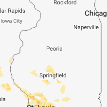


Cities Most Affected by Hail Storms of 6/28/2018
| Hail Size | Demographics of Zip Codes Affected | ||||||
|---|---|---|---|---|---|---|---|
| City | Count | Average | Largest | Pop Density | House Value | Income | Age |
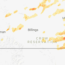
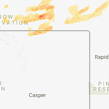
| Hettinger, ND | 3 | 2.75 | 3.00 | 2 | $42k | $29.8k | 49.3 |
| Miles City, MT | 4 | 2.00 | 2.50 | 3 | $63k | $29.9k | 41.9 |
| Harvey, ND | 3 | 2.50 | 3.00 | 6 | $49k | $33.4k | 50.7 |
| Broadus, MT | 3 | 2.08 | 2.50 | 0 | $58k | $27.8k | 49.9 |
| Larimore, ND | 2 | 1.75 | 1.75 | 4 | $67k | $36.7k | 41.8 |
| Scranton, ND | 1 | 2.50 | 2.50 | 1 | $39k | $31.9k | 49.4 |
| Bena, MN | 1 | 1.75 | 1.75 | 5 | $33k | $24.2k | 31.7 |
| Fulton, MS | 1 | 1.75 | 1.75 | 54 | $61k | $30.8k | 38.2 |
| Hammond, MT | 1 | 1.75 | 1.75 | 0 | $71k | $14.6k | 45.5 |
| Circle, MT | 1 | 1.75 | 1.75 | 0 | $43k | $28.5k | 47.1 |
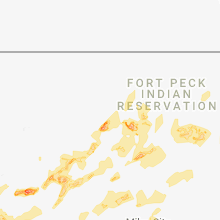
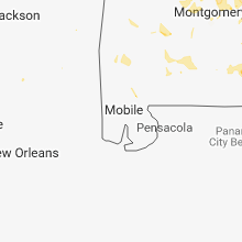
Hail and Wind Damage Spotted on 6/28/2018
Filter by Report Type:Hail ReportsWind Reports
States Impacted
North Dakota, Nebraska, Tennessee, Georgia, Missouri, Iowa, Illinois, Minnesota, Kentucky, Alabama, Florida, Montana, Colorado, Mississippi, Arkansas, South DakotaNorth Dakota
| Local Time | Report Details |
|---|---|
| 6:08 AM MDT | Tennis Ball sized hail reported near Scranton, ND, 121.4 miles WSW of Bismarck, ND, report relayed by broadcast media. |
| 6:12 AM MDT | Half Dollar sized hail reported near Scranton, ND, 121.4 miles WSW of Bismarck, ND, hail ongoing at time of report. relayed by media. |
| 6:54 AM MDT | Baseball sized hail reported near Hettinger, ND, 101.3 miles WSW of Bismarck, ND, adams county em relayed a public report of baseball size hail... with extensive damage to homes (broken windows... damaged siding/roofs). time of report estimated based |
| 6:58 AM MDT | Tea Cup sized hail reported near Hettinger, ND, 101 miles WSW of Bismarck, ND |
| 7:07 AM MDT | Tennis Ball sized hail reported near Hettinger, ND, 94.3 miles WSW of Bismarck, ND, deputy in adams county reported damage to vehicles... with many windows broken out due to large hail up to 2.5 inches in diameter. |
| 8:10 AM MDT | Quarter sized hail reported near Carson, ND, 57.7 miles SW of Bismarck, ND, quarter sized hail lasted 5 minutes in duration. the duration of the hail event was 5 minutes. |
| 12:45 PM CDT | Quarter sized hail reported near Grand Forks, ND, 73.4 miles N of Fargo, ND, photo of one inch hail relayed via social media. time is radar estimated. |
| 12:49 PM CDT | Heavy rain causing some street flooding near 8th ave. north and 43rd. water up to the the cur in grand forks county ND, 74.2 miles N of Fargo, ND |
| 3:34 PM CDT | Golf Ball sized hail reported near Larimore, ND, 55.2 miles ESE of Devils Lake, ND, reported along highway 2... about 3 miles west of nd18 intersection. |
| 3:34 PM CDT | Golf Ball sized hail reported near Larimore, ND, 55.7 miles ESE of Devils Lake, ND, reported along highway 2. |
| 3:35 PM CDT | Quarter sized hail reported near Larimore, ND, 58.6 miles ESE of Devils Lake, ND, social media post showing hail slightly larger than quarter sized. |
| 3:43 PM CDT | Quarter sized hail reported near Larimore, ND, 62.1 miles E of Devils Lake, ND, large hail spread across highway 2 just west of turtle river state park. time estimated based on radar. |
| 4:32 PM CDT | Quarter sized hail reported near Watford City, ND, 21.5 miles SE of Williston, ND |
| 8:20 PM CDT | Quarter sized hail reported near Esmond, ND, 39.9 miles W of Devils Lake, ND, public estimated pea to quarter sized hail. |
| 8:48 PM CDT | Ping Pong Ball sized hail reported near Harvey, ND, 56.5 miles WSW of Devils Lake, ND, ping pong ball size ongoing. |
| 8:50 PM CDT | Golf Ball sized hail reported near Harvey, ND, 55.5 miles WSW of Devils Lake, ND |
| 9:00 PM CDT | Tea Cup sized hail reported near Harvey, ND, 55.1 miles WSW of Devils Lake, ND, tea cup size hail... lasted 15 minutes ... from 9pm until 915pm. |
| 9:03 PM CDT | Baseball sized hail reported near Harvey, ND, 55.5 miles WSW of Devils Lake, ND, golf ball to baseball size hail reported in harvey. duration 10 minutes. |
| 9:25 PM CDT | Torrential rai in williams county ND, 8.2 miles W of Williston, ND |
| 9:29 PM CDT | Pea size hai in williams county ND, 8.2 miles W of Williston, ND |
| 9:38 PM CDT | 68 mph wind gust recorded at sloulin field international airpor in williams county ND, 2.4 miles NNW of Williston, ND |
| 9:40 PM CDT | Storm damage reported in mckenzie county ND, 21.2 miles S of Williston, ND |
| 8:45 PM MDT | Ping Pong Ball sized hail reported near Halliday, ND, 70.4 miles SW of Minot, ND, marble size hail lasted 20 to 30 minutes. largest hail was ping-pong size. |
| 8:48 PM MDT | Quarter sized hail reported near Halliday, ND, 77.6 miles SW of Minot, ND |
| 9:57 PM CDT | Estimated 60 to 70 mph wind in mckenzie county ND, 28.7 miles SSE of Williston, ND |
| 9:06 PM MDT | Quarter sized hail reported near Halliday, ND, 70.1 miles SW of Minot, ND, hail lasted about 5 minutes until 1011 pm. |
| 10:09 PM CDT | Storm damage reported in williams county ND, 27.2 miles NE of Williston, ND |
| 10:15 PM CDT | Recorded at the watford city airpor in mckenzie county ND, 29.3 miles SE of Williston, ND |
| 10:15 PM CDT | Damage to homes reported with siding torn off. time is radar estimated. report passed to nws from broadcast medi in williams county ND, 24.8 miles ENE of Williston, ND |
| 10:30 PM CDT | Estimated winds of 70 to 75 mph were accompanied by heavy rai in williams county ND, 36 miles ENE of Williston, ND |
| 9:48 PM MDT | Mesonet station nd006... 1 nne frybur in billings county ND, 87.5 miles S of Williston, ND |
| 10:12 PM MDT | In addition... 1.35 inches of rain in the past hou in dunn county ND, 72.1 miles SE of Williston, ND |
| 10:15 PM MDT | Quarter sized hail reported near Rhame, ND, 95.3 miles E of Miles City, MT |
| 10:21 PM MDT | Ping Pong Ball sized hail reported near Scranton, ND, 127.7 miles N of Rapid City, SD |
| 12:02 AM CDT | Thunderstorm winds of 50 to 60 mph lasted about 4 minutes... until 1206 am. large branches were blown dow in morton county ND, 50.9 miles WNW of Bismarck, ND |
| 12:12 AM CDT | Storm damage reported in mchenry county ND, 15.3 miles ESE of Minot, ND |
| 11:15 PM MDT | Time estimated from rada in mercer county ND, 46 miles NW of Bismarck, ND |
| 12:20 AM CDT | Branches down in hebron. report relayed by broadcast meteorologist. wind speed estimate in morton county ND, 60.6 miles W of Bismarck, ND |
| 12:33 AM CDT | Ndot wind equipmen in morton county ND, 31.1 miles W of Bismarck, ND |
| 12:48 AM CDT | Storm damage reported in mclean county ND, 36.2 miles NNW of Bismarck, ND |
| 12:50 AM CDT | Trees and power lines down near county road 2 in mclean county ND, 35.4 miles NNW of Bismarck, ND |
| 12:53 AM CDT | Storm damage reported in mclean county ND, 49.1 miles SSE of Minot, ND |
| 1:00 AM CDT | Storm damage reported in mclean county ND, 35.5 miles NNW of Bismarck, ND |
| 1:09 AM CDT | Major tree damage reported just south of double ditc in burleigh county ND, 10.3 miles NNW of Bismarck, ND |
| 1:15 AM CDT | Storm damage reported in burleigh county ND, 2.9 miles NE of Bismarck, ND |
| 1:27 AM CDT | Northwest bismarc in burleigh county ND, 2.2 miles NW of Bismarck, ND |
| 1:33 AM CDT | Submitted through nws web page reporting for in burleigh county ND, 1.7 miles NE of Bismarck, ND |
| 1:35 AM CDT | Also had pea size hail and 0.90 inches of rain. report relayed through broadcast meteorologist to nw in burleigh county ND, 4.9 miles SE of Bismarck, ND |
| 1:47 AM CDT | Storm damage reported in burleigh county ND, 27 miles ESE of Bismarck, ND |
| 2:03 AM CDT | Ndot wind equipmmen in burleigh county ND, 25.2 miles E of Bismarck, ND |
| 2:06 AM CDT | Storm damage reported in wells county ND, 57.4 miles WSW of Devils Lake, ND |
| 2:50 AM CDT | Lasted about 5 minutes until 255 am. no reports of damag in stutsman county ND, 70.3 miles E of Bismarck, ND |
| 2:55 AM CDT | Awos measured wind gust to 58 mp in towner county ND, 30.4 miles NNW of Devils Lake, ND |
| 3:21 AM CDT | Personal davis weather station reported 96 mph wind gus in griggs county ND, 53.3 miles SE of Devils Lake, ND |
| 3:33 AM CDT | 3 inch diameter limbs. power poles broken. time is radar estimate in barnes county ND, 57.3 miles W of Fargo, ND |
| 3:43 AM CDT | Public personal weather underground station reported wind gust of 63 mp in barnes county ND, 45 miles WSW of Fargo, ND |
| 8:45 AM UTC | Measured on davis personal weather statio in steele county ND, 59.4 miles NW of Fargo, ND |
| 3:58 AM CDT | Public personal weather underground station reported wind gust of 70 mp in grand forks county ND, 53.6 miles ESE of Devils Lake, ND |
| 4:00 AM CDT | Large tree branches felled. report via social medi in nelson county ND, 24 miles ESE of Devils Lake, ND |
| 4:00 AM CDT | Several trees felled in hillsboro. report received via social medi in traill county ND, 38.5 miles NNW of Fargo, ND |
| 4:07 AM CDT | Ndawn mesonet site measured 58 mph wind gus in eddy county ND, 31.7 miles SSE of Devils Lake, ND |
| 4:12 AM CDT | Grand forks airport asos measured 76 mph wind gus in grand forks county ND, 74.7 miles NNW of Fargo, ND |
| 4:12 AM CDT | Grand forks afb asos measured 62 mph wind gus in grand forks county ND, 67.9 miles E of Devils Lake, ND |
| 4:30 AM CDT | Plenty of trees down on highway 15. report received via social medi in traill county ND, 59.6 miles NNW of Fargo, ND |
| 4:49 AM CDT | Part of fence blown off at residence in south grand forks. report via social medi in grand forks county ND, 73.4 miles N of Fargo, ND |
| 6:00 AM CDT | Trampoline re arranged within backyard. event time is time of report... damage would have occurred earlier. reported via social medi in nelson county ND, 34.6 miles E of Devils Lake, ND |
| 6:20 AM CDT | Tree... plenty of branches down at emergency manager residence. damage resulted from high wind subsequent to the earlier bow echo... which did not cause any damage in t in walsh county ND, 61.5 miles ENE of Devils Lake, ND |
Nebraska
| Local Time | Report Details |
|---|---|
| 7:25 AM CDT | Report of several branches snapped off of trees and damage to corn crops. time estimated based on radar dat in boone county NE, 47.2 miles SE of Oneill, NE |
| 7:34 AM CDT | Quarter sized hail reported near Petersburg, NE, 50.5 miles SE of Oneill, NE, 1 inch hail and large tree limbs down. |
| 7:34 AM CDT | Winds of 77 mph measured at davis weather statio in antelope county NE, 46.4 miles SE of Oneill, NE |
| 7:34 AM CDT | One two foot diameter ash tree blown down. a lot of tree limbs down. from fire dept and emergency manage in boone county NE, 51.1 miles SE of Oneill, NE |
| 7:36 AM CDT | Reports of power out and several large limbs down in newman grov in madison county NE, 64.2 miles NNE of Grand Island, NE |
| 7:44 AM CDT | Davis weather station reports winds of 79 mp in madison county NE, 64.3 miles NNE of Grand Island, NE |
| 8:11 AM CDT | Report of an empty grain bin blown down... relayed by stanton county emergency management. time estimated based on rada in madison county NE, 71.1 miles ESE of Oneill, NE |
| 8:35 AM CDT | Report of trees snapped and one small tree uprooted. relayed by stanton county emergency management. time estimated based on rada in stanton county NE, 71.4 miles WNW of Omaha, NE |
| 9:43 AM CDT | Storm damage reported in burt county NE, 36.6 miles NNW of Omaha, NE |
| 9:45 AM CDT | Estimated 65 mph winds and several 4+ inch tree limbs down throughout the city of tekama in burt county NE, 38.7 miles NNW of Omaha, NE |
| 4:45 PM MDT | Quarter sized hail reported near Hay Springs, NE, 65.4 miles NE of Scottsbluff, NE, largest hail size estimated 1 inch. |
Tennessee
| Local Time | Report Details |
|---|---|
| 8:54 AM EDT | Multiple trees dow in rhea county TN, 48.7 miles NE of Chattanooga, TN |
| 8:54 AM EDT | Multiple trees dow in meigs county TN, 48.4 miles NE of Chattanooga, TN |
| 9:00 AM CDT | Few trees dow in bledsoe county TN, 39.3 miles N of Chattanooga, TN |
| 9:30 AM CDT | Several trees down across the northern half of the count in sequatchie county TN, 22.8 miles NNW of Chattanooga, TN |
| 10:30 AM EDT | Several trees dow in polk county TN, 38.5 miles ENE of Chattanooga, TN |
| 10:25 AM CDT | Few trees dow in sequatchie county TN, 18.2 miles NNW of Chattanooga, TN |
| 10:38 AM CDT | Multiple reports of trees down in spring hill including a tree on a house on neely's ben in maury county TN, 30.5 miles SSW of Nashville, TN |
| 11:01 AM CDT | The front of an auto parts store was ripped of in marshall county TN, 49.5 miles S of Nashville, TN |
| 11:04 AM CDT | Tree damage was reported off old columbia rd in unionvill in bedford county TN, 42.8 miles SSE of Nashville, TN |
| 11:04 AM CDT | Several reports of trees down in lewisbur in marshall county TN, 49.5 miles S of Nashville, TN |
| 11:20 AM CDT | Couple trees and a few power lines dow in marion county TN, 22.8 miles W of Chattanooga, TN |
| 11:38 AM CDT | Reports of trees down county wide. time is radar estimate in henry county TN, 16.4 miles NE of Mc Kenzie, TN |
| 11:45 AM CDT | Trees down at highland rim road. time estimated from rada in lincoln county TN, 64.7 miles ENE of Florence, AL |
| 11:50 AM CDT | Tree on house on mason road in flintvill in lincoln county TN, 63.5 miles W of Chattanooga, TN |
| 12:00 PM CDT | Several trees down on south pittsburg mountai in marion county TN, 26.7 miles W of Chattanooga, TN |
| 12:03 PM CDT | Trees down in lynnvill in giles county TN, 54.9 miles NE of Florence, AL |
| 12:03 PM CDT | Report of powerlines down and multiple trees down. time of event is radar estimate in benton county TN, 24 miles ESE of Mc Kenzie, TN |
| 12:05 PM CDT | Emergency manager reported trees down county wid in stewart county TN, 44.9 miles ENE of Mc Kenzie, TN |
| 12:12 PM CDT | Trees down near camp garners creek on garners creek roa in dickson county TN, 41.1 miles WSW of Nashville, TN |
| 12:21 PM CDT | Trees reported down at orchard hill rd fayetteville...t in lincoln county TN, 65.2 miles ENE of Florence, AL |
| 12:22 PM CDT | Trees down county wide in hickman count in hickman county TN, 44.2 miles WSW of Nashville, TN |
| 12:22 PM CDT | Tree down on power line on march mill road near fayettevill in lincoln county TN, 65.9 miles S of Nashville, TN |
| 12:23 PM CDT | Tree down on a house in vanntown are in lincoln county TN, 65.3 miles W of Chattanooga, TN |
| 12:25 PM CDT | Tree down on highway 117 near the tn state line at sherwoo in franklin county TN, 33.7 miles W of Chattanooga, TN |
| 12:26 PM CDT | Trees down in dickson county in dickson county TN, 34.2 miles W of Nashville, TN |
| 12:30 PM CDT | A downed tree was fully blocking cowan rd near reidland d in dickson county TN, 34.6 miles WSW of Nashville, TN |
| 12:30 PM CDT | Trees down and power outages reporte in hickman county TN, 48 miles WSW of Nashville, TN |
| 12:35 PM CDT | One house on mobley ridge rd sustained wind damag in hickman county TN, 42.9 miles SW of Nashville, TN |
| 12:38 PM CDT | Tree reported down on the power lines at morrison stree in hickman county TN, 43.9 miles SW of Nashville, TN |
| 12:45 PM CDT | Numerous trees down in northern perry count in perry county TN, 48.2 miles ESE of Mc Kenzie, TN |
| 12:53 PM CDT | Trees down on south fork r in maury county TN, 50.4 miles SSW of Nashville, TN |
| 12:53 PM CDT | Trees down in the mount pleasant are in maury county TN, 48.5 miles SSW of Nashville, TN |
| 1:03 PM CDT | Numerous trees and power lines down around the intersection of elk ridge road and enterprise roa in maury county TN, 52.9 miles SSW of Nashville, TN |
| 1:11 PM CDT | A tree snapped and fell on power line in lawrence county TN, 41.7 miles NNE of Florence, AL |
| 1:19 PM CDT | New prospect fire reported several trees down from lawrenceburg east to the county lin in lawrence county TN, 36.9 miles NE of Florence, AL |
| 1:25 PM CDT | Several reports of trees down in pulask in giles county TN, 45.8 miles NE of Florence, AL |
| 1:27 PM CDT | Trees down in anthony hil in giles county TN, 39.3 miles NE of Florence, AL |
| 4:55 PM CDT | Strong winds took down swaths of trees along powell chapel road south through pocahonta in hardeman county TN, 67.2 miles WNW of Florence, AL |
| 4:57 PM CDT | Power lines and trees down on highway 57 between middleton and pocahonta in hardeman county TN, 65.9 miles E of Memphis, TN |
| 9:15 PM CDT | Estimated winds of 60 mp in lake county TN, 55.7 miles WNW of Mc Kenzie, TN |
| 9:16 PM CDT | A few trees down on old highway 79 east of dove in stewart county TN, 49.2 miles ENE of Mc Kenzie, TN |
| 9:23 PM CDT | Wind gusts to 60 mph in union cit in obion county TN, 35.6 miles NW of Mc Kenzie, TN |
| 9:25 PM CDT | Estimated 65 mph winds in pari in henry county TN, 16.4 miles NE of Mc Kenzie, TN |
| 9:30 PM CDT | Estimated 70 mph in routon 8 miles south of pari in henry county TN, 10.3 miles NE of Mc Kenzie, TN |
| 9:30 PM CDT | Several reports of trees down. time estimated by rada in weakley county TN, 13.9 miles NW of Mc Kenzie, TN |
| 9:45 PM CDT | Numerous reports of trees down in camde in benton county TN, 24 miles ESE of Mc Kenzie, TN |
| 9:50 PM CDT | Reports of trees down in greenfield area. time estimated by rada in weakley county TN, 15.8 miles W of Mc Kenzie, TN |
| 9:53 PM CDT | 60 mph gusts estimate in gibson county TN, 26.1 miles WSW of Mc Kenzie, TN |
| 9:56 PM CDT | Gutter torn off city hal in carroll county TN, 16.7 miles ESE of Mc Kenzie, TN |
| 9:56 PM CDT | Gutter torn off city hal in carroll county TN, 16.7 miles ESE of Mc Kenzie, TN |
| 10:25 PM CDT | Estimated 58 mph win in henderson county TN, 29.8 miles S of Mc Kenzie, TN |
| 10:40 PM CDT | Several large trees down on providence road near interstate 4 in madison county TN, 49.5 miles SSW of Mc Kenzie, TN |
Georgia
| Local Time | Report Details |
|---|---|
| 10:02 AM EDT | A tree and power lines were reported down on highway 82 near marlow circl in jackson county GA, 54.9 miles NE of Atlanta, GA |
| 10:31 AM EDT | Power pole reported down at the intersection of aska rd and deep gap r in fannin county GA, 59.4 miles ESE of Chattanooga, TN |
| 10:45 AM EDT | Several trees and power lines reported down near the intersection of zion hill rd and gates chapel r in gilmer county GA, 48.5 miles ESE of Chattanooga, TN |
| 10:49 AM EDT | Tree reported down at the intersection of apison rd and lucydee wa in whitfield county GA, 20.5 miles ESE of Chattanooga, TN |
| 10:55 AM EDT | A few trees and utility lines down in the 1000 block of old hwy 5 n. vehicle wrecked in this area as well... but no injuries have been reporte in gilmer county GA, 53.5 miles ESE of Chattanooga, TN |
| 11:06 AM EDT | Several trees and power lines reported down along sunlight r in gilmer county GA, 52.3 miles ESE of Chattanooga, TN |
| 11:12 AM EDT | A large tree was reported down on highway 136 near grand view road. the tree has been cleare in pickens county GA, 53.2 miles N of Atlanta, GA |
| 11:30 AM EDT | A tree was reported down on state route 83 before fairplay roa in morgan county GA, 51.3 miles E of Atlanta, GA |
| 11:42 AM EDT | Multiple trees down along hwy-411 from ranger to fairmon in gordon county GA, 50.8 miles SE of Chattanooga, TN |
| 11:43 AM EDT | A tree was reported down on old jones roa in cherokee county GA, 31.2 miles N of Atlanta, GA |
| 11:54 AM EDT | A large tree was reported in the road blocking both lanes on upper bethany road near the intersection of stancil roa in cherokee county GA, 42.4 miles N of Atlanta, GA |
| 11:54 AM EDT | A tree was reported down on south baggett roa in douglas county GA, 24.2 miles W of Atlanta, GA |
| 11:55 AM EDT | A tree was reported down on yeager roa in douglas county GA, 22.1 miles W of Atlanta, GA |
| 11:55 AM EDT | A tree was reported down on highway 166 near big a roa in douglas county GA, 23.8 miles WSW of Atlanta, GA |
| 12:06 PM EDT | Tree reported down at three notch rd and burning bush r in catoosa county GA, 16 miles SSE of Chattanooga, TN |
| 12:10 PM EDT | Reports of downed trees causing damage to homes. one on garden grove dr caused extensive damage to the home as the tree fell through the living room. another on sydney in gwinnett county GA, 24 miles NE of Atlanta, GA |
| 12:11 PM EDT | A tree was reported down at union hill road and east cherokee driv in cherokee county GA, 31.8 miles N of Atlanta, GA |
| 12:26 PM EDT | Tree reported down at temperance hall rd and rodeo r in catoosa county GA, 18.9 miles SSE of Chattanooga, TN |
| 12:29 PM EDT | A few trees were reported down along highway 27 near culberson avenu in walker county GA, 23.2 miles S of Chattanooga, TN |
| 12:40 PM EDT | A tree was reported down in the roadway near the intersection of spring creek road and spring hill lan in chattooga county GA, 34.9 miles S of Chattanooga, TN |
| 12:54 PM EDT | A tree was reported down on john west road near brightstar elementary schoo in douglas county GA, 22.4 miles W of Atlanta, GA |
| 12:59 PM EDT | A tree was reported down on poplar springs road near rocking r ranch circl in chattooga county GA, 45.3 miles S of Chattanooga, TN |
| 1:00 PM EDT | A tree was reported down on chapel hill road at chapel valley roa in douglas county GA, 19.7 miles WSW of Atlanta, GA |
| 1:13 PM EDT | A tree was reported down near the intersection of first street and thomas road. another tree was reported down on pine stree in chattooga county GA, 34.2 miles S of Chattanooga, TN |
| 1:20 PM EDT | A tree was reported down in the roadway on holland chattoogaville road and sling alley roa in chattooga county GA, 49.2 miles S of Chattanooga, TN |
| 1:22 PM EDT | Power lines reported down at the 100 block of laura lan in fayette county GA, 26.8 miles SSW of Atlanta, GA |
| 1:25 PM EDT | A tree was reported down on west haven drive. another tree was reported down on acadia driv in floyd county GA, 53.6 miles S of Chattanooga, TN |
| 1:25 PM EDT | A tree was reported down on kenwood driv in floyd county GA, 54.4 miles S of Chattanooga, TN |
| 1:25 PM EDT | A tree was reported down on williamsburg driv in floyd county GA, 52.2 miles S of Chattanooga, TN |
| 1:27 PM EDT | A tree was reported down on a house on williamsburg driv in floyd county GA, 52.2 miles S of Chattanooga, TN |
| 1:30 PM EDT | Several trees are down on powerlines off hwy 74 in southern peachtree city across the street from the peachtree city athletic comple in fayette county GA, 29.1 miles SSW of Atlanta, GA |
| 1:30 PM EDT | Tree blown down on moore rd near valley hill... blocking both lanes of traffi in spalding county GA, 29.5 miles S of Atlanta, GA |
| 1:35 PM EDT | A tree was reported down on sixth av in chattooga county GA, 38.9 miles SSW of Chattanooga, TN |
| 1:42 PM EDT | A tree was reported down in the roadway blocking all lanes on highway 74 at mile marker 1 in upson county GA, 58.8 miles S of Atlanta, GA |
| 1:44 PM EDT | Report vis twitter of a tree down along alabama hwy between rome and coosa in floyd county GA, 53.6 miles S of Chattanooga, TN |
| 1:48 PM EDT | Report of a tree that fell down on a house on pleasant grove road in yatesville... ga causing major structural damag in upson county GA, 64.8 miles SSE of Atlanta, GA |
| 1:55 PM EDT | Report of a tree that fell down on a house on pleasant grove road in yatesville... ga causing major structural damag in upson county GA, 64.8 miles SSE of Atlanta, GA |
| 2:00 PM EDT | A tree was reported down in the roadway blocking both direction on highway 74 at pickard roa in upson county GA, 58.5 miles S of Atlanta, GA |
| 2:01 PM EDT | A tree was reported down in the roadway blocking both lanes on highway 36 at antler roa in upson county GA, 59.9 miles S of Atlanta, GA |
| 4:24 PM EDT | Ga 511 reports utility lines downed on hwy 300 and pateville rd in crisp county GA, 63.4 miles WNW of Douglas, GA |
| 4:55 PM EDT | Tree down on hwy 34 and woodbine circle in heard county GA, 47.4 miles NNE of Auburn, AL |
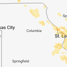
Missouri
| Local Time | Report Details |
|---|---|
| 9:40 AM CDT | Tree down and hail... size of hail unknown in bollinger county MO, 25.3 miles WNW of Cape Girardeau, MO |
| 9:45 AM CDT | Large tree limbs down. received via social medi in cape girardeau county MO, 6.9 miles W of Cape Girardeau, MO |
| 10:00 AM CDT | Numerous trees and power lines down. report received via social medi in cape girardeau county MO, 0.6 miles NNW of Cape Girardeau, MO |
| 10:02 AM CDT | Wind gusts estimated 60 to 65 mp in cape girardeau county MO, 0.6 miles NNW of Cape Girardeau, MO |
| 10:15 AM CDT | Power lines down... power outages reported. report received via social medi in scott county MO, 14 miles S of Cape Girardeau, MO |
| 10:26 AM CDT | Several thousand customers without power in southern cape girardeau county and northern scott count in cape girardeau county MO, 0.6 miles NNW of Cape Girardeau, MO |
| 1:03 PM CDT | Ping Pong Ball sized hail reported near Unionville, MO, 68.1 miles W of Kahoka, MO, quarter to ping pong ball size hail. |
| 1:55 PM CDT | *** 1 inj *** delayed report and time estimated from radar. woman hospitalized from falling tree. reported by wge in scotland county MO, 23.9 miles W of Kahoka, MO |
| 2:05 PM CDT | Storm damage reported in adair county MO, 47.9 miles WSW of Kahoka, MO |
| 3:45 PM CDT | Tree across roa in ralls county MO, 60.2 miles SSE of Kahoka, MO |
| 4:20 PM CDT | Power line dow in pike county MO, 63.2 miles NW of Saint Louis, MO |
| 4:22 PM CDT | A tree was downed and a stop sign was knocked ove in pike county MO, 66.8 miles ENE of Columbia, MO |
| 4:38 PM CDT | Large tree blocking riverview dr. time estimated by rada in st. louis city county MO, 8.4 miles N of Saint Louis, MO |
| 4:40 PM CDT | Multiple reports of trees knocked dow in lincoln county MO, 48.8 miles NW of Saint Louis, MO |
| 5:17 PM CDT | Wires down on veterans memorial and elm street near lindenwood university. twitter repor in st. charles county MO, 19.8 miles WNW of Saint Louis, MO |
| 5:17 PM CDT | Storm damage reported in st. charles county MO, 24.3 miles NNW of Saint Louis, MO |
| 5:23 PM CDT | Boats cast into the main channel. dock flipped over. pickup truck flipped over. damage located at my river home boat harbou in st. charles county MO, 22.2 miles NNW of Saint Louis, MO |
| 5:28 PM CDT | Large branches and power lines down. time estimated from radar. twitter repor in st. louis county MO, 13.6 miles NNW of Saint Louis, MO |
| 5:28 PM CDT | Measured by oregon scientific instrument at hwy 270 and lindenberg blv in st. louis county MO, 13.6 miles NW of Saint Louis, MO |
| 5:28 PM CDT | High voltage power lines down; pole to pole. time estimated by rada in st. louis city county MO, 3.7 miles N of Saint Louis, MO |
| 5:33 PM CDT | Corrects previous tstm wnd dmg report from spanish lake. report via social media of tree down. also a shed torn off. time estimated from rada in st. louis county MO, 11.2 miles N of Saint Louis, MO |
| 5:33 PM CDT | Corrects previous tstm wnd dmg report from spanish lake. report via social media of tree down. also a shed torn off. time estimated from rada in st. louis county MO, 11.2 miles N of Saint Louis, MO |
| 5:36 PM CDT | Bus stop blown into the street and many limbs dow in st. louis county MO, 12 miles N of Saint Louis, MO |
| 5:36 PM CDT | Bus stop blown into the street and many limbs dow in st. louis county MO, 12 miles N of Saint Louis, MO |
| 5:38 PM CDT | Report via social media of tree dow in st. louis county MO, 10.6 miles NNW of Saint Louis, MO |
| 5:38 PM CDT | Large tree branches on power lines and blocking riverview drive near chambers roa in st. louis county MO, 8.4 miles N of Saint Louis, MO |
| 5:41 PM CDT | Large tree uprooted blocking fountain avenu in st. louis city county MO, 4 miles NW of Saint Louis, MO |
| 5:41 PM CDT | Report via social media of large tree limb dow in st. louis county MO, 17.6 miles NW of Saint Louis, MO |
| 5:42 PM CDT | Light pole snapped near base. time estimated from radar. twitter repor in st. louis city county MO, 0.5 miles ENE of Saint Louis, MO |
| 5:54 PM CDT | Media report via social media. trees and power lines down. time estimated from rada in st. louis city county MO, 2.8 miles NW of Saint Louis, MO |
| 5:56 PM CDT | Large healthy trees topple in st. louis city county MO, 4 miles NW of Saint Louis, MO |
| 5:57 PM CDT | Report via social media of tree down. time estimated from rada in st. louis county MO, 10.3 miles WSW of Saint Louis, MO |
| 6:50 PM CDT | *** 1 inj *** a person was hit by awning at intersection of hwy 51 and 61 due to strong wind in perry county MO, 34.5 miles NNW of Cape Girardeau, MO |
| 7:22 PM CDT | Large tree down by railroad crossin in st. louis county MO, 10.3 miles WSW of Saint Louis, MO |
| 7:50 PM CDT | *** 1 inj *** a person was hit by awning at intersection of hwy 51 and 61 due to strong wind in perry county MO, 34.5 miles NNW of Cape Girardeau, MO |
| 8:00 PM CDT | Trees and power lines down across highway in st. francois county MO, 52.6 miles E of Salem, MO |
| 8:20 PM CDT | Large tree down near teen challenge in jackson in cape girardeau county MO, 7 miles NW of Cape Girardeau, MO |
| 10:02 PM CDT | Trees dow in wayne county MO, 47.2 miles WSW of Cape Girardeau, MO |
Iowa
| Local Time | Report Details |
|---|---|
| 9:40 AM CDT | Pea-sized hail and tree branches down with thunderstorm wind gust in harrison county IA, 33.2 miles N of Omaha, NE |
| 10:00 AM CDT | Barn destroye in harrison county IA, 34.7 miles NNE of Omaha, NE |
| 10:06 AM CDT | Very large tree limbs over 1 foot down and power ou in harrison county IA, 31.3 miles N of Omaha, NE |
| 10:09 AM CDT | Personal weather station measured gust of 59 mp in harrison county IA, 27.8 miles NNE of Omaha, NE |
| 10:45 AM CDT | Corrects previous tstm wnd dmg report from 3 e oakland. 14 inch tree limb dow in pottawattamie county IA, 31.5 miles E of Omaha, NE |
| 10:47 AM CDT | Storm damage reported in shelby county IA, 42 miles NE of Omaha, NE |
| 10:50 AM CDT | Large limbs and whole trees down in walnut with several city streets blocked. at least one semi blown over along i-80 north of walnut. sounded tornado sirens in walnut in pottawattamie county IA, 40.7 miles ENE of Omaha, NE |
| 10:53 AM CDT | Several very large limbs down. 24 inch or more limbs and trees down in avoca and across highway 5 in pottawattamie county IA, 35 miles ENE of Omaha, NE |
| 10:55 AM CDT | Storm damage reported in cass county IA, 47.4 miles ENE of Omaha, NE |
| 11:01 AM CDT | 14 inch tree limb dow in pottawattamie county IA, 31.5 miles E of Omaha, NE |
| 11:10 AM CDT | Multiple trees down with branches 3 inches or greater in diameter throughout the town via social media pictures. time estimated via radar in cass county IA, 49.3 miles ENE of Omaha, NE |
| 11:20 AM CDT | Rwis statio in adair county IA, 53.5 miles W of Des Moines, IA |
| 11:20 AM CDT | Delayed repor in cass county IA, 59.8 miles E of Omaha, NE |
| 11:20 AM CDT | Corrects previous tstm wnd dmg report from 2 s massena. delayed report. 3"diameter tree branches down. few farm sheds toppled. wide swaths of corn bent down in the vici in cass county IA, 61 miles E of Omaha, NE |
| 11:25 AM CDT | In greenfield and fontanelle. 8 to 10 inch diameter trees down...branches... fences down. greenhouse blown over at shopko in greenfield. dime size hail with high winds in adair county IA, 47.9 miles WSW of Des Moines, IA |
| 11:28 AM CDT | Video via social medi in adams county IA, 65.6 miles SW of Des Moines, IA |
| 11:30 AM CDT | Picture of tree trunk snapped via social media in adair county IA, 48.6 miles WSW of Des Moines, IA |
| 11:32 AM CDT | Estimated 70 mph wind gust. numerous tree branches down blocking some street in adair county IA, 47.9 miles WSW of Des Moines, IA |
| 11:35 AM CDT | Significant wind damage in adair county around greenfield. radio tower on hospital down... home damage 3 south of greenfield. numerous large trees down across the are in butler county IA, 28.8 miles SE of Mason City, IA |
| 11:35 AM CDT | Significant wind damage in adair county near greenfield. multiple trees down... home damage 3 south of greenfield and radio tower on hospital dow in adair county IA, 49.1 miles WSW of Des Moines, IA |
| 11:39 AM CDT | From personal weather station at intersection of cherry street and rea roa in union county IA, 50.9 miles SW of Des Moines, IA |
| 11:40 AM CDT | At creston airpor in union county IA, 53.3 miles SW of Des Moines, IA |
| 11:40 AM CDT | Estimated 65 mph winds along with nickle hail and at least 3 inch branches down. visibility near zero in heavy rai in adair county IA, 39.3 miles WSW of Des Moines, IA |
| 11:45 AM CDT | Electricity is ou in union county IA, 52.4 miles SW of Des Moines, IA |
| 11:50 AM CDT | Kcci reports multiple tree branches down around town. town is without powe in union county IA, 49.2 miles SW of Des Moines, IA |
| 11:50 AM CDT | Powerlines down along highway 34 in cresto in union county IA, 53.4 miles SW of Des Moines, IA |
| 11:53 AM CDT | Multiple small branches blown down via social media in madison county IA, 35.3 miles WSW of Des Moines, IA |
| 11:54 AM CDT | Machine shed destroyed... grain bin severely damage and multiple trees dow in adair county IA, 46.8 miles WSW of Des Moines, IA |
| 11:56 AM CDT | Branches down at location in winterset. wind estimate in madison county IA, 26.8 miles SW of Des Moines, IA |
| 12:05 PM CDT | Large trees and power lines down in murra in clarke county IA, 41.1 miles SSW of Des Moines, IA |
| 12:10 PM CDT | Social media report showing numerous large trees down in st. charle in madison county IA, 23 miles SSW of Des Moines, IA |
| 12:14 PM CDT | Truck overturned on interstate 35 near mile marker 5 in warren county IA, 19.9 miles SSW of Des Moines, IA |
| 12:14 PM CDT | Multiple tree branches down 3 inches or greater near warren county fairground via social media. time estimated via rada in warren county IA, 16 miles S of Des Moines, IA |
| 12:15 PM CDT | 8 inch tree down covering the road. estimated 60 mph wind gusts. nickel hai in madison county IA, 17.4 miles SSW of Des Moines, IA |
| 12:15 PM CDT | Storm damage reported in warren county IA, 16.1 miles S of Des Moines, IA |
| 12:16 PM CDT | Quarter sized hail reported near Murray, IA, 42.4 miles SSW of Des Moines, IA |
| 12:17 PM CDT | Multiple tree branches down 3 inches and greater along hwy. 92 in indianola via social media pictures. time estimated by rada in warren county IA, 16 miles S of Des Moines, IA |
| 12:18 PM CDT | Several reports of trees down between martensdale and indianol in warren county IA, 15.9 miles SSW of Des Moines, IA |
| 12:22 PM CDT | Tree branch split at 43rd and dawson in cumming via social media picture. time estimated via rada in warren county IA, 10.6 miles SW of Des Moines, IA |
| 12:22 PM CDT | Reported at boston ave indianola... ia via social media. large trees down... damage to vehicles. knocked power lines down. time estimated via rada in warren county IA, 16 miles S of Des Moines, IA |
| 12:24 PM CDT | Storm damage reported in warren county IA, 16.1 miles S of Des Moines, IA |
| 12:24 PM CDT | Multiple 1 to 2 inch tree branches down in cumming via social medi in warren county IA, 10.6 miles SW of Des Moines, IA |
| 12:25 PM CDT | Large tree down on hous in warren county IA, 16 miles S of Des Moines, IA |
| 12:28 PM CDT | Grain bins knocked over... widespread tree damage... including trees snapped at the trun in warren county IA, 12.6 miles S of Des Moines, IA |
| 12:32 PM CDT | Large tree down on house from kcci viewe in polk county IA, 5 miles SSW of Des Moines, IA |
| 12:32 PM CDT | Large tree fell on roof of home via social media picture. time estimated by rada in warren county IA, 8.9 miles SSW of Des Moines, IA |
| 12:32 PM CDT | Storm damage reported in polk county IA, 4.1 miles SSW of Des Moines, IA |
| 12:33 PM CDT | Small tree uprooted via social medi in polk county IA, 4.9 miles S of Des Moines, IA |
| 12:35 PM CDT | Mutliple 1-2 inch branches are down along union street near warren county border. a few branches are 3 to 4 inches in diamete in warren county IA, 7 miles SSW of Des Moines, IA |
| 12:45 PM CDT | Several large trees down in knoxvill in marion county IA, 32.6 miles SE of Des Moines, IA |
| 12:48 PM CDT | Many branches or trees down...3 inches or more in diameter. 2.5 inches of rain fell in one half hour. pea sized hail. wind gusts estimated at 76 to 85 mp in warren county IA, 7 miles SSW of Des Moines, IA |
| 12:59 PM CDT | 6 to 12 inch trees down. power lines dow in marion county IA, 31.6 miles SE of Des Moines, IA |
| 1:00 PM CDT | Numerous trees down in albia via social media picture in monroe county IA, 57.4 miles SE of Des Moines, IA |
| 1:25 PM CDT | Tree down on house. time estimated by rada in wapello county IA, 55.4 miles NW of Kahoka, MO |
| 1:32 PM CDT | Rwis repor in wapello county IA, 55.3 miles NW of Kahoka, MO |
| 1:38 PM CDT | Via social medi in wapello county IA, 55.7 miles NW of Kahoka, MO |
| 1:38 PM CDT | Quarter sized hail reported near Ottumwa, IA, 55.7 miles NW of Kahoka, MO, via social media. |
| 2:05 PM CDT | Winds occurred around 205 p in clark county MO, 13.3 miles NNW of Kahoka, MO |
| 2:15 PM CDT | Time estimated. 12 inch diameter tree downed by thunderstorm wind in clark county MO, 13.3 miles NNW of Kahoka, MO |
| 2:17 PM CDT | 3 inch limb broke in lee county IA, 17.4 miles E of Kahoka, MO |
| 2:33 PM CDT | Power lines dow in lee county IA, 30.6 miles NE of Kahoka, MO |
| 2:37 PM CDT | Corrects previous tstm wnd dmg report from 1 ese keokuk. 3 inch limb broke in lee county IA, 17.4 miles E of Kahoka, MO |
| 2:40 PM CDT | Tree limbs and wires down on avenue in lee county IA, 23.8 miles NE of Kahoka, MO |
| 2:45 PM CDT | Delayed report and time estimated. 1 and 2 inch limbs down. basketball hoop at hawthorn elementary ben in lee county IA, 16.9 miles E of Kahoka, MO |
| 2:47 PM CDT | Large tree limb down possibly 4 inches in diameter. time estimated from rada in lee county IA, 17.4 miles E of Kahoka, MO |
| 2:58 PM CDT | Trees dow in des moines county IA, 41.4 miles NE of Kahoka, MO |
| 6:44 PM CDT | Delayed report. 3"diameter tree branches down. few farm sheds toppled. wide swaths of corn bent down in the vicinit in cass county IA, 61 miles E of Omaha, NE |
Illinois
| Local Time | Report Details |
|---|---|
| 10:14 AM CDT | Pecan tree branch with a diameter of 14 inches fell on a mobile home. relayed via facebook. delayed repor in alexander county IL, 6.4 miles E of Cape Girardeau, MO |
| 2:50 PM CDT | Large tree limb down... report via social medi in hancock county IL, 24.9 miles E of Kahoka, MO |
| 3:13 PM CDT | Delayed report via social media. time estimated from radar. trees and tree limbs dow in henderson county IL, 51.1 miles ENE of Kahoka, MO |
| 3:15 PM CDT | Tree limbs down from public via wgem. time approximate in hancock county IL, 42.7 miles ESE of Kahoka, MO |
| 3:20 PM CDT | Numerous tree limbs down on the north side of macomb. time estimated from rada in mcdonough county IL, 54.9 miles E of Kahoka, MO |
| 3:44 PM CDT | Numerous tree limbs and power lines down in schuyler county IL, 64.2 miles ESE of Kahoka, MO |
| 3:45 PM CDT | Large tree split and fell onto a church. relayed via wgem-tv in schuyler county IL, 64.2 miles ESE of Kahoka, MO |
| 3:48 PM CDT | Numerous tree limbs and power lines down. time estimated by radar in cass county IL, 64.7 miles SW of Peoria, IL |
| 3:53 PM CDT | Tree limbs and powerlines down in fulton county IL, 36.2 miles WSW of Peoria, IL |
| 3:57 PM CDT | Tree blown down in mason county IL, 45.3 miles SW of Peoria, IL |
| 4:00 PM CDT | Tree blown down in mason county IL, 33.8 miles SW of Peoria, IL |
| 4:03 PM CDT | Tree limbs down along u.s. highway 136 in mason county IL, 35.4 miles SW of Peoria, IL |
| 4:20 PM CDT | Power line down in morgan county IL, 74.6 miles SSW of Peoria, IL |
| 4:20 PM CDT | 6 inch thick limb down off a black walnut tre in morgan county IL, 67.9 miles N of Saint Louis, MO |
| 4:30 PM CDT | Tree dow in pike county IL, 66.6 miles NNW of Saint Louis, MO |
| 4:30 PM CDT | Trees and power lines down in mason county IL, 34.5 miles S of Peoria, IL |
| 4:35 PM CDT | Trees and power lines down in morgan county IL, 65.7 miles N of Saint Louis, MO |
| 4:39 PM CDT | 4 inch tree limb down on the 700 block of shoshoni d in sangamon county IL, 64.6 miles S of Peoria, IL |
| 4:40 PM CDT | Limbs down in sangamon county IL, 63 miles S of Peoria, IL |
| 4:41 PM CDT | Power line down on 400 block of main street in sangamon county IL, 70.8 miles S of Peoria, IL |
| 4:42 PM CDT | 18 inch diameter tree uprooted along with numerous tree limbs down in auburn in sangamon county IL, 70 miles NNE of Saint Louis, MO |
| 4:50 PM CDT | Tree down and multiple tree limbs down. time estimated by rada in sangamon county IL, 68.3 miles W of Mattoon, IL |
| 4:50 PM CDT | 3 inch tree limb down. report from mping project in sangamon county IL, 68.2 miles W of Mattoon, IL |
| 4:59 PM CDT | Tree across highway 1 in jersey county IL, 36.5 miles NNW of Saint Louis, MO |
| 4:59 PM CDT | 6 inch tree limb down on a car in logan county IL, 39.1 miles SSE of Peoria, IL |
| 5:01 PM CDT | 3 inch tree limb down. report from mping project in sangamon county IL, 68.2 miles W of Mattoon, IL |
| 5:17 PM CDT | Numerous trees and limbs down around elsah. minor roof damage to homes and outbuildings as well. time estimated from rada in jersey county IL, 24.5 miles NNW of Saint Louis, MO |
| 5:22 PM CDT | Power poll knocked dow in montgomery county IL, 50.5 miles WSW of Mattoon, IL |
| 5:23 PM CDT | Tree down across il route in macoupin county IL, 48.2 miles NNE of Saint Louis, MO |
| 5:23 PM CDT | Large tree limb down blocking the road at lincoln and bolls in macon county IL, 42.5 miles WNW of Mattoon, IL |
| 5:26 PM CDT | Trees knocked onto mobile home. pea sized hai in madison county IL, 23.6 miles N of Saint Louis, MO |
| 5:26 PM CDT | Tree across highway 11 in jersey county IL, 27.9 miles N of Saint Louis, MO |
| 5:27 PM CDT | Large tree broken at the base. social media repor in christian county IL, 36.1 miles W of Mattoon, IL |
| 5:30 PM CDT | Trained spotter reported construction trailer at fireworks stand blown off block in madison county IL, 18.1 miles N of Saint Louis, MO |
| 5:34 PM CDT | Large tree down and fell on neighbors garag in madison county IL, 18.1 miles N of Saint Louis, MO |
| 5:35 PM CDT | Tree limbs down in kitchell park. report via social media in christian county IL, 38.2 miles W of Mattoon, IL |
| 5:41 PM CDT | Picture of two trees uprooted received via twitter pos in madison county IL, 28.5 miles NE of Saint Louis, MO |
| 5:42 PM CDT | 4 to 5 inch diameter tree limbs dow in madison county IL, 18.1 miles N of Saint Louis, MO |
| 5:44 PM CDT | Media report via social media of large trees uprooted. time estimated from rada in madison county IL, 6.5 miles NNE of Saint Louis, MO |
| 5:44 PM CDT | Media report via social media of tree down in granite cit in madison county IL, 5.9 miles NNE of Saint Louis, MO |
| 5:45 PM CDT | Small tree snapped. facebook repor in madison county IL, 15.4 miles NE of Saint Louis, MO |
| 5:49 PM CDT | Several large trees down in wilson par in madison county IL, 6.8 miles NNE of Saint Louis, MO |
| 5:49 PM CDT | Tractor trailer blown over at the intersection of i-55 and 203 via social media post. time estimated by rada in madison county IL, 9.9 miles ENE of Saint Louis, MO |
| 5:52 PM CDT | Large tree split and part of it fell down. social media repor in shelby county IL, 23.2 miles WSW of Mattoon, IL |
| 5:53 PM CDT | Trees uprooted and machine shed completely destroye in madison county IL, 20.2 miles N of Saint Louis, MO |
| 5:55 PM CDT | Several wooden fences down. power outages also reporte in madison county IL, 29.1 miles ENE of Saint Louis, MO |
| 6:00 PM CDT | Tree downed on car. additional reports of trees and power lines down sporadically across the count in fayette county IL, 45.3 miles SW of Mattoon, IL |
| 6:02 PM CDT | Tree down across power lin in bond county IL, 46.8 miles ENE of Saint Louis, MO |
| 6:02 PM CDT | Report via social media of tree uprooted. time estimated from rada in st. clair county IL, 13.7 miles ESE of Saint Louis, MO |
| 6:02 PM CDT | Several trees dow in st. clair county IL, 11 miles E of Saint Louis, MO |
| 6:02 PM CDT | Tree down at douglas and third street. time estimated by rada in madison county IL, 24.1 miles ENE of Saint Louis, MO |
| 6:03 PM CDT | Minor damage to an apartment complex along joseph drive in fairview heights. time estimated from rada in st. clair county IL, 12.3 miles ESE of Saint Louis, MO |
| 6:05 PM CDT | Public report via social media of trees and power poles snapped off. time estimated from rada in st. clair county IL, 8.1 miles ESE of Saint Louis, MO |
| 6:05 PM CDT | Tree limbs down on highway 128 in effingham county IL, 35.3 miles SW of Mattoon, IL |
| 6:07 PM CDT | Large trees down and debri in st. clair county IL, 20 miles ESE of Saint Louis, MO |
| 6:07 PM CDT | Power poles down in town. estimated by rada in clinton county IL, 31.8 miles E of Saint Louis, MO |
| 6:08 PM CDT | 6 inch in diameter tree limb down and at least 50 mph wind gust. currently without powe in clinton county IL, 32.5 miles E of Saint Louis, MO |
| 6:10 PM CDT | Large trees dow in clinton county IL, 36.1 miles E of Saint Louis, MO |
| 6:15 PM CDT | Numerous trees blown down. time estimated by rada in clinton county IL, 36 miles E of Saint Louis, MO |
| 6:18 PM CDT | Part of the roof of the aviston family restaurant is missin in clinton county IL, 31.9 miles E of Saint Louis, MO |
| 6:20 PM CDT | Tree limbs down near the i-57 exit in effingham county IL, 34.3 miles SSW of Mattoon, IL |
| 6:23 PM CDT | Trained spotter reported 4 to 5 inch diameter tree limbs dow in clinton county IL, 40 miles E of Saint Louis, MO |
| 6:25 PM CDT | Tree limb down across highway 37 in effingham county IL, 38.9 miles SSW of Mattoon, IL |
| 6:28 PM CDT | Widespread tree damage across washington count in washington county IL, 48.4 miles ESE of Saint Louis, MO |
| 6:31 PM CDT | Numerous trees snapped. time estimated from radar. twitter repor in marion county IL, 58.3 miles E of Saint Louis, MO |
| 6:36 PM CDT | Tree down on oak mound lane. time estimated by rada in clay county IL, 56.4 miles SSW of Mattoon, IL |
| 6:43 PM CDT | Tree down on 500 block of east 4th street. time estimated by rada in clay county IL, 56.3 miles S of Mattoon, IL |
| 6:50 PM CDT | Multiple trees reported down across town. entire town without powe in perry county IL, 60.3 miles NNE of Cape Girardeau, MO |
| 6:55 PM CDT | Power outages reported throughout the count in jefferson county IL, 73.1 miles ESE of Saint Louis, MO |
| 6:58 PM CDT | Multiple reports of trees down in the pinckneyville area. at least one tree down on power line in perry county IL, 54.4 miles N of Cape Girardeau, MO |
| 7:00 PM CDT | Estimated wind gusts of 70 mph as it moved through tow in franklin county IL, 60.7 miles NNE of Cape Girardeau, MO |
| 7:00 PM CDT | Estimated at least 60 mph winds. multiple power poles down including one trapping a vehicle on state hwy 154 at rend lak in franklin county IL, 63 miles NNE of Cape Girardeau, MO |
| 7:00 PM CDT | Multiple reports of trees and limbs down across tow in perry county IL, 50.9 miles NNE of Cape Girardeau, MO |
| 7:05 PM CDT | 75 mph gust measured by wunderground personal weather statio in wayne county IL, 61.5 miles WNW of Evansville, IN |
| 7:05 PM CDT | Trees down on power lines. up to 2 foot diameter tree branches down on north side of town. street flooding occurrin in franklin county IL, 59.6 miles NE of Cape Girardeau, MO |
| 7:05 PM CDT | Multiple trees down in the west city are in franklin county IL, 58.1 miles NE of Cape Girardeau, MO |
| 7:13 PM CDT | 67 mph wind gust recorded at southern illinois airport in carbondal in jackson county IL, 33.9 miles NNE of Cape Girardeau, MO |
| 7:15 PM CDT | Winds estimated at 60+ mph in carterville in williamson county IL, 40.6 miles NE of Cape Girardeau, MO |
| 7:15 PM CDT | Winds estimated at 60+ mph in carterville in williamson county IL, 40.6 miles NE of Cape Girardeau, MO |
| 7:15 PM CDT | Numerous reports of trees... power lines... and large tree limbs down. widespread power outage in williamson county IL, 44.4 miles NE of Cape Girardeau, MO |
| 7:18 PM CDT | Multiple trees down in carbondale. spotter reported a possible funnel clou in jackson county IL, 33.9 miles NNE of Cape Girardeau, MO |
| 7:20 PM CDT | 65 mph wind gusts on west side of marion in williamson county IL, 42.8 miles NE of Cape Girardeau, MO |
| 7:20 PM CDT | Large tree blocking illinois rt 34 north of tow in saline county IL, 53.7 miles W of Evansville, IN |
| 7:20 PM CDT | Multiple trees blown down... power poles down... intense lightning. old route 13 blocked due to multiple trees across road between giant city rd and reed station r in jackson county IL, 33.9 miles NNE of Cape Girardeau, MO |
| 7:20 PM CDT | Sign blown apart at the harrisburg-raleigh airport. delayed repor in saline county IL, 56.3 miles WSW of Evansville, IN |
| 7:25 PM CDT | Multiple trees down and structural damag in williamson county IL, 49.1 miles NE of Cape Girardeau, MO |
| 7:28 PM CDT | Public report of a boat dock being ripped off by wind in williamson county IL, 41 miles NE of Cape Girardeau, MO |
| 7:30 PM CDT | Multiple power outages... trees and power lines down throughout the county. structural damage as wel in williamson county IL, 44.4 miles NE of Cape Girardeau, MO |
| 7:30 PM CDT | Tree damage and power lines down in carbondal in jackson county IL, 33.9 miles NNE of Cape Girardeau, MO |
| 7:32 PM CDT | Quarter sized hail reported near Prairie Du Rocher, IL, 38.2 miles S of Saint Louis, MO, photo of quarter-sized hail. time estimated from radar. |
| 7:35 PM CDT | Numerous trees down in saline count in saline county IL, 56.3 miles WSW of Evansville, IN |
| 7:40 PM CDT | Tree split in half and landed on a home. resident oka in johnson county IL, 33.7 miles ENE of Cape Girardeau, MO |
| 7:42 PM CDT | Numerous trees and large limbs down as well as power line in franklin county IL, 53.2 miles NE of Cape Girardeau, MO |
| 7:45 PM CDT | Several trees blocking hwy 145 between delwood and eddyville. also several trees down blocking eddyville blacktop between flick hill and hwy 146 in golcond in pope county IL, 54.2 miles ENE of Cape Girardeau, MO |
| 7:45 PM CDT | Report of roof blown off of gallatin county school. time estimated by rada in gallatin county IL, 41 miles WSW of Evansville, IN |
| 7:50 PM CDT | Widespread trees and power lines down across the county in johnson county IL, 36.8 miles ENE of Cape Girardeau, MO |
| 7:52 PM CDT | Tree down on a house in norris city and multiple trees down in the are in white county IL, 41.8 miles W of Evansville, IN |
| 7:53 PM CDT | Sporadic trees down in tow in monroe county IL, 28.1 miles S of Saint Louis, MO |
| 8:00 PM CDT | Tree fell on a traile in massac county IL, 45.3 miles E of Cape Girardeau, MO |
| 8:00 PM CDT | Roof lifted off quint excavating on west 10th stree in massac county IL, 47.2 miles ESE of Cape Girardeau, MO |
| 8:10 PM CDT | Large tree uprooted and has fallen on a mobile home carpor in massac county IL, 55.2 miles ESE of Cape Girardeau, MO |
Minnesota
| Local Time | Report Details |
|---|---|
| 10:45 AM CDT | Half Dollar sized hail reported near Grand Rapids, MN, 63 miles ESE of Bemidji, MN, spotter reported 1 inch hail with a few stones to half-dollar size. |
| 12:45 PM CDT | Quarter sized hail reported near East Grand Forks, MN, 73.7 miles N of Fargo, ND, photo of hail ranging from nickel to quarter sized relayed via social media. time is radar estimated. |
| 1:00 PM CDT | Half Dollar sized hail reported near East Grand Forks, MN, 74.2 miles N of Fargo, ND, photo relayed through social media shows hail slightly larger than quarter sized. |
| 1:40 PM CDT | Quarter sized hail reported near Crookston, MN, 64.3 miles N of Fargo, ND |
| 1:45 PM CDT | Quarter sized hail reported near Crookston, MN, 62.3 miles N of Fargo, ND |
| 1:50 PM CDT | A few large 3-4 inch diamter tree branches broken down in town. a few minutes of pea to penny sized hail as wel in polk county MN, 50.7 miles N of Fargo, ND |
| 2:25 PM CDT | Ping Pong Ball sized hail reported near Bemidji, MN, 6.6 miles NE of Bemidji, MN, hail fell for several minutes. largest stones ranged from 1.25 to 1.5 inch diameter. report and photo posted to social media. |
| 2:30 PM CDT | Quarter sized hail reported near Bemidji, MN, 9.3 miles ENE of Bemidji, MN, very heavy rain and penny to quarter sized hail. |
| 2:30 PM CDT | Quarter sized hail reported near Bemidji, MN, 8.2 miles NE of Bemidji, MN, very heavy rain and penny to quarter sized hail. |
| 2:40 PM CDT | Quarter sized hail reported near Fertile, MN, 52.1 miles NNE of Fargo, ND |
| 2:41 PM CDT | Quarter sized hail reported near Swatara, MN, 62.4 miles SE of Bemidji, MN, largest hail was slightly larger than a quarter. |
| 2:45 PM CDT | Quarter sized hail reported near Trail, MN, 48.3 miles WNW of Bemidji, MN, penny to quarter sized hail and strong winds. some 2-3 inch diameter branches broken down in yard. |
| 2:55 PM CDT | Golf Ball sized hail reported near Bena, MN, 32.1 miles ESE of Bemidji, MN, pea to golf ball-sized hail fell for over 7 minutes along with heavy rain. |
| 3:13 PM CDT | Quarter sized hail reported near Bena, MN, 33 miles ESE of Bemidji, MN, report of cherry tomato-sized hail at a resort on the south shore of lake winnibigoshish. |
| 3:30 PM CDT | Quarter sized hail reported near Redlake, MN, 34.3 miles NW of Bemidji, MN, hail to quater or a bit larger size noted on highway 1... off the southwest edge of lower red lake. |
| 4:40 PM CDT | Trees down across hwy 61 south of mahtow in carlton county MN, 30.2 miles WSW of Duluth, MN |
| 4:40 PM CDT | Numerous 30-40 foot tall trees down both north and south of the barnum exit along i-3 in carlton county MN, 33.2 miles SW of Duluth, MN |
| 5:28 PM CDT | Large pine tree fell on hous in carlton county MN, 34.4 miles SW of Duluth, MN |
| 6:12 PM CDT | Quarter sized hail reported near Willow River, MN, 47.8 miles SW of Duluth, MN, radar estimated time. |
| 6:25 PM CDT | Quarter sized hail reported near Bruno, MN, 46.9 miles SW of Duluth, MN, update to previous report of nickel sized hail. hail lasted between 6:23 pm - 6:35 pm. |
| 4:21 AM CDT | Public davis weather station reported wind gust of 62 mp in polk county MN, 75.2 miles N of Fargo, ND |
| 4:27 AM CDT | Hendrum rwis reported 70 mph wind gus in norman county MN, 29.3 miles N of Fargo, ND |
| 5:05 AM CDT | Brooks rwis measured 65 mph wind gus in red lake county MN, 56.2 miles WNW of Bemidji, MN |
| 5:40 AM CDT | Numerous trees down 10 miles northwest of bemidji. reported by emergency manage in beltrami county MN, 10.2 miles NW of Bemidji, MN |
| 5:48 AM CDT | Public weather bug statio in beltrami county MN, 28.9 miles NNW of Bemidji, MN |
| 6:00 AM CDT | Extensive tree damage throughout the area. reported by emergency manage in beltrami county MN, 36.2 miles NNE of Bemidji, MN |
| 11:40 AM UTC | Four wheel utility wagon turned over. event probably occurred sometime before reporttime.reported via social medi in clearwater county MN, 24.8 miles W of Bemidji, MN |
Kentucky
| Local Time | Report Details |
|---|---|
| 11:15 AM CDT | Power lines down across the southern portion of graves county. report received via social medi in graves county KY, 37.1 miles NNW of Mc Kenzie, TN |
| 11:45 AM CDT | Numerous trees snapped or down. some fell on outbuildings. most of the damage occurred along faxon roa in calloway county KY, 34.7 miles NNE of Mc Kenzie, TN |
| 11:50 AM CDT | Em reports numerous trees down across the eastern half of the count in calloway county KY, 36.7 miles NNE of Mc Kenzie, TN |
| 11:50 AM CDT | Metal building blown down and pushed 100 yards along faxon road. time estimate in calloway county KY, 35.5 miles NNE of Mc Kenzie, TN |
| 11:51 AM CDT | Tree fell across old newburg road and onto a car. report received via e in calloway county KY, 39.3 miles NNE of Mc Kenzie, TN |
| 11:55 AM CDT | Trees down along portions of ky highway 94 northeast of tow in calloway county KY, 35.8 miles NNE of Mc Kenzie, TN |
| 11:58 AM CDT | Wind estimated. large tree limbs snapped. report received via social medi in calloway county KY, 38.5 miles NNE of Mc Kenzie, TN |
| 7:15 PM CDT | Several trees uprooted on hwy 60 near intersection of hwy 135 in livingston county KY, 63.7 miles E of Cape Girardeau, MO |
| 8:09 PM CDT | Measured wind gust to 62 mph at kpah aso in mccracken county KY, 47 miles ESE of Cape Girardeau, MO |
| 8:10 PM CDT | Several reports of trees and large limbs down in massac county IL, 52 miles ESE of Cape Girardeau, MO |
| 8:10 PM CDT | Numerous reports of trees and power lines down and some power outages in the paducah are in mccracken county KY, 52.4 miles ESE of Cape Girardeau, MO |
| 8:15 PM CDT | Numerous trees down across the count in ballard county KY, 35.5 miles ESE of Cape Girardeau, MO |
| 8:15 PM CDT | Large tree took down power poles and lines in front of a hous in graves county KY, 51.1 miles ESE of Cape Girardeau, MO |
| 8:20 PM CDT | Estimated 60 mph wind in mccracken county KY, 59.5 miles ESE of Cape Girardeau, MO |
| 8:20 PM CDT | 8-10 inch diameter tree down and 6 foot fence panel dow in marshall county KY, 57.8 miles N of Mc Kenzie, TN |
| 8:21 PM CDT | Power outages reported in lone oa in mccracken county KY, 51.5 miles ESE of Cape Girardeau, MO |
| 8:30 PM CDT | 80 percent of town without powe in marshall county KY, 50.2 miles N of Mc Kenzie, TN |
| 8:40 PM CDT | Estimated 60 mph winds in farmington in graves county KY, 35.7 miles N of Mc Kenzie, TN |
| 8:40 PM CDT | Tree on house in cunningham area on county road 1054. multiple trees down throughout the count in carlisle county KY, 43.9 miles SE of Cape Girardeau, MO |
| 8:44 PM CDT | Tree down on a hous in graves county KY, 51.1 miles ESE of Cape Girardeau, MO |
| 8:45 PM CDT | Hwy 62 between cunningham and bardwell basically impassable due to so many trees across the road. widespread tree damage across the count in carlisle county KY, 43.9 miles SE of Cape Girardeau, MO |
| 8:45 PM CDT | Large maple tree down onto power line on peggy ann drive on south side of murra in calloway county KY, 34.1 miles NNE of Mc Kenzie, TN |
| 8:49 PM CDT | Multiple trees down on the north side of cadi in trigg county KY, 64 miles NE of Mc Kenzie, TN |
| 8:50 PM CDT | Several reports of large tree limbs and trees down along with power outages in graves county KY, 45.8 miles NNW of Mc Kenzie, TN |
| 8:52 PM CDT | Widespread power outages reported in trigg count in trigg county KY, 64 miles NE of Mc Kenzie, TN |
| 8:52 PM CDT | Widespread power outages reported in ballard count in ballard county KY, 35.5 miles ESE of Cape Girardeau, MO |
| 9:00 PM CDT | 65 mph winds estimated and power is out on hwy 91 at sinking fork church in christian county KY, 66.8 miles NW of Nashville, TN |
| 9:02 PM CDT | Estimated 700-800 customers without power in the fredonia are in caldwell county KY, 59.5 miles SSW of Evansville, IN |
| 9:10 PM CDT | Near sinking fork school on highway 91 northwest of hopkinsville in christian county KY, 65.9 miles NW of Nashville, TN |
| 9:14 PM CDT | Power outage reported for the entire hazel are in calloway county KY, 28.1 miles NNE of Mc Kenzie, TN |
Alabama
| Local Time | Report Details |
|---|---|
| 12:15 PM CDT | Widespread snapped trees with some trees falling on houses in killingsworth cove area. damage consistent with 100 mph was observed throughout the neighborhood with tree in madison county AL, 62.4 miles WSW of Chattanooga, TN |
| 12:27 PM CDT | Trees down reported at wooley springs r in limestone county AL, 50.8 miles E of Florence, AL |
| 12:27 PM CDT | Several trees down at mckee and wooley springs road in tone in limestone county AL, 50.7 miles E of Florence, AL |
| 12:34 PM CDT | Tree on power line reported at southern oaks at linda moores mill...a in madison county AL, 66.8 miles E of Florence, AL |
| 12:38 PM CDT | Trees and power lines down reported at cr 784 ider...a in dekalb county AL, 26.9 miles SW of Chattanooga, TN |
| 12:40 PM CDT | Tree on house reported at 2300 block virgina blvd huntsville...a in madison county AL, 61.8 miles E of Florence, AL |
| 12:42 PM CDT | Tree reported down on country road 155 near cartersvill in dekalb county AL, 25.6 miles SW of Chattanooga, TN |
| 12:51 PM CDT | Trees on power lines. two utility poles needed to be replaced. reported via decatur utilitie in morgan county AL, 46.6 miles ESE of Florence, AL |
| 12:53 PM CDT | Tree down reported at cr 14 al hwy 117 flat rock...a in jackson county AL, 30.2 miles SW of Chattanooga, TN |
| 1:00 PM CDT | Tree down at lake guntersville state park reported at old hwy 227 ... guntersville...a in marshall county AL, 63.5 miles SW of Chattanooga, TN |
| 1:01 PM CDT | Tree in road reported at cathedral caverns hwy and white elephant rd... marshall county... a in marshall county AL, 68.4 miles SW of Chattanooga, TN |
| 1:02 PM CDT | Tree down reported at 2152 cr 271 fort payne... a in dekalb county AL, 51.5 miles SSW of Chattanooga, TN |
| 1:04 PM CDT | Trees down reported at college st... scottsboro...a in jackson county AL, 48.5 miles WSW of Chattanooga, TN |
| 1:04 PM CDT | Trees down reported at widgeon dr... scottsboro...a in jackson county AL, 52.2 miles SW of Chattanooga, TN |
| 1:05 PM CDT | Guntersville state park area superintendent reports 50-60 mph wind gus in marshall county AL, 67.5 miles SW of Chattanooga, TN |
| 1:07 PM CDT | Tree fell on a house. reported at winchester and shields rd... huntsville...a in madison county AL, 65.7 miles E of Florence, AL |
| 1:15 PM CDT | Tree down at county road 124 and county road 390 with road blockag in jackson county AL, 47.7 miles SW of Chattanooga, TN |
| 1:15 PM CDT | Trees down on county road 14 at flat roc in jackson county AL, 27.1 miles WSW of Chattanooga, TN |
| 1:15 PM CDT | Tree down blocking county road 27 between the blake community and sylvani in dekalb county AL, 45 miles SW of Chattanooga, TN |
| 1:15 PM CDT | Power lines down at intersection of warrenton road and bow range roa in marshall county AL, 62.8 miles NNE of Birmingham, AL |
| 1:15 PM CDT | Tree down at county road 17 at skyline monument compan in jackson county AL, 52.5 miles WSW of Chattanooga, TN |
| 1:16 PM CDT | Trees down reported at worthington st... scottsboro...a in jackson county AL, 49.8 miles WSW of Chattanooga, TN |
| 1:17 PM CDT | Tree blocking roadway on county road 206 in bridgepor in jackson county AL, 24.6 miles WSW of Chattanooga, TN |
| 1:17 PM CDT | Tree reported down at intersection of county road 23 and alabama highway 7 in dekalb county AL, 62.2 miles SW of Chattanooga, TN |
| 1:20 PM CDT | Tree down reported down at college avenue in collinsvill in dekalb county AL, 62 miles SSW of Chattanooga, TN |
| 1:24 PM CDT | Tree down reported on county road 9 near liberty church in the geraldine communit in dekalb county AL, 67.1 miles SW of Chattanooga, TN |
| 1:25 PM CDT | Tree fell on highway 35 on the side of the mountain near sectio in jackson county AL, 49.9 miles SW of Chattanooga, TN |
| 1:25 PM CDT | Multiple trees down in cedar bluff per e in cherokee county AL, 64.5 miles SSW of Chattanooga, TN |
| 1:25 PM CDT | Tree down on house per e in cherokee county AL, 58.8 miles SSW of Chattanooga, TN |
| 1:25 PM CDT | Quarter sized hail reported near Leesburg, AL, 61.5 miles SSW of Chattanooga, TN, 1 inch hail reported per em in sand rock... time estimated by radar. |
| 1:26 PM CDT | Trees down on shady lane at county road 8 in the pleasant grove communit in jackson county AL, 54.8 miles WSW of Chattanooga, TN |
| 1:30 PM CDT | Trees snapped and uprooted on lake shore drive in scottsboro area via twitte in jackson county AL, 50.8 miles SW of Chattanooga, TN |
| 1:30 PM CDT | Tree reported down on power lines and residence on county road 8 (1790) near town of crossvill in dekalb county AL, 67.3 miles SW of Chattanooga, TN |
| 1:30 PM CDT | Storm damage reported in dekalb county AL, 62.6 miles SSW of Chattanooga, TN |
| 1:32 PM CDT | Tree across county road 535 in the boxes cove community northwest of scottsbor in jackson county AL, 51.4 miles WSW of Chattanooga, TN |
| 1:40 PM CDT | 1 mile n of elkmont. 62 mph wind. 6 inch tree tops/limbs are snappe in limestone county AL, 41.1 miles ENE of Florence, AL |
| 1:40 PM CDT | 1 mile n of elkmont. 62 mph wind. 6 inch tree tops/limbs are snappe in limestone county AL, 41.1 miles ENE of Florence, AL |
| 1:40 PM CDT | House fire due to tree down on power lines at 2747 county road in dekalb county AL, 66.6 miles NE of Birmingham, AL |
| 1:43 PM CDT | Tree down at intersection of county road 115 and county road 243 south of fort payn in dekalb county AL, 55.3 miles SSW of Chattanooga, TN |
| 1:43 PM CDT | Trees down reported at new garden rd elkmont...a in limestone county AL, 42.5 miles E of Florence, AL |
| 1:44 PM CDT | Tree down on county road 479 in the kilpatrick communit in dekalb county AL, 65.7 miles NE of Birmingham, AL |
| 1:45 PM CDT | Live wire down across the road at pattys rod sho in cullman county AL, 48.3 miles N of Birmingham, AL |
| 1:45 PM CDT | Trees and powerlines down blocking the road at highway 31 and highway 15 in cullman county AL, 47.6 miles N of Birmingham, AL |
| 1:46 PM CDT | Multiple trees down near reece city per e in etowah county AL, 57.9 miles NE of Birmingham, AL |
| 1:47 PM CDT | Structural damage to roof of gas station in gadsden. also reports of trees and power lines down in attalla per e in etowah county AL, 57.6 miles NE of Birmingham, AL |
| 1:47 PM CDT | Tree down reported at intersection of county road 25 and cr 26 near crossvill in dekalb county AL, 66.8 miles NE of Birmingham, AL |
| 1:48 PM CDT | Power line down across county road 67 at chisenhall spring near langsto in jackson county AL, 53.8 miles SW of Chattanooga, TN |
| 1:50 PM CDT | Mping report of 3 200 foot tall pine trees snapped east of athens. time estimated by rada in limestone county AL, 43.5 miles E of Florence, AL |
| 1:56 PM CDT | Tree down on county road 253 near kilpatric in dekalb county AL, 67 miles NE of Birmingham, AL |
| 1:58 PM CDT | Tree down on house with power lines down on county road 25 near crossvill in dekalb county AL, 67.8 miles NE of Birmingham, AL |
| 2:00 PM CDT | Tree down on road near intersection of highway 168 and needmore road near dougla in marshall county AL, 56.7 miles NE of Birmingham, AL |
| 2:00 PM CDT | The high school stadium bleachers at clements high school were heavily damage in limestone county AL, 28.2 miles E of Florence, AL |
| 2:00 PM CDT | A tree was blown down onto a house... on keener drive in leesbur in cherokee county AL, 65.5 miles SSW of Chattanooga, TN |
| 2:01 PM CDT | A large tree was blown down and blocked the road at cedar street and mcelrath street... in cedar bluf in cherokee county AL, 59.5 miles SSW of Chattanooga, TN |
| 2:02 PM CDT | Trees and powerlines down on cr 26 near blountsvill in blount county AL, 38.6 miles NNE of Birmingham, AL |
| 2:02 PM CDT | Trees down on chestnut street in gadsde in etowah county AL, 56.2 miles NE of Birmingham, AL |
| 2:02 PM CDT | Trees down on rocky hollow road near attall in etowah county AL, 48.3 miles NE of Birmingham, AL |
| 2:02 PM CDT | Power lines down on old camp road... near gadsde in etowah county AL, 62.4 miles NE of Birmingham, AL |
| 2:06 PM CDT | Storm damage reported in etowah county AL, 63.5 miles ENE of Birmingham, AL |
| 2:07 PM CDT | Tree across road at intersection of highway 207 and highway 9 in lauderdale county AL, 26.5 miles ENE of Florence, AL |
| 2:10 PM CDT | Trees down at intersection of elkton road and myrtlewood driv in limestone county AL, 41.9 miles E of Florence, AL |
| 2:10 PM CDT | Trees down at intersection of chapman hollow road/easter ferry roa in limestone county AL, 33.5 miles ENE of Florence, AL |
| 2:10 PM CDT | Reported in nances creek are in calhoun county AL, 70.4 miles ENE of Birmingham, AL |
| 2:10 PM CDT | Trees and power lines down on a residence in the coates bend are in etowah county AL, 63.5 miles ENE of Birmingham, AL |
| 2:11 PM CDT | A large tree down on east river roa in morgan county AL, 55.8 miles ESE of Florence, AL |
| 2:13 PM CDT | Tree down on taits gap loo in blount county AL, 39 miles NE of Birmingham, AL |
| 2:15 PM CDT | Trees and power lines down on clay street and ridge road intersectio in limestone county AL, 40.9 miles ENE of Florence, AL |
| 2:15 PM CDT | Trees and power lines down along county road 3 in cullman county AL, 31.2 miles N of Birmingham, AL |
| 2:15 PM CDT | Tree across road along county road 109 between highway 69s and j&d fourway gas statio in cullman county AL, 35.5 miles NNW of Birmingham, AL |
| 2:17 PM CDT | Numerous trees down around the city of attall in etowah county AL, 54 miles NE of Birmingham, AL |
| 2:18 PM CDT | Several trees and power lines down... some on structures... on nisbet lake road area... near jacksonvill in calhoun county AL, 63.2 miles ENE of Birmingham, AL |
| 2:20 PM CDT | Tree across road at 5750 county road 104 in cullman county AL, 50.8 miles NNW of Birmingham, AL |
| 2:22 PM CDT | Trees down on greensport roa in calhoun county AL, 53.6 miles ENE of Birmingham, AL |
| 2:25 PM CDT | Attalla opera house damage in etowah county AL, 54.4 miles NE of Birmingham, AL |
| 2:25 PM CDT | Several trees down in multiple spots across the north part of the count in talladega county AL, 40.2 miles E of Birmingham, AL |
| 2:25 PM CDT | Several trees down in multiple areas across the north part of the count in st. clair county AL, 31.4 miles E of Birmingham, AL |
| 2:27 PM CDT | Tree down near wvok radio statio in calhoun county AL, 56.4 miles E of Birmingham, AL |
| 2:28 PM CDT | Tree down on quintard avenue... between 14th and 15th streets... in annisto in calhoun county AL, 57.4 miles E of Birmingham, AL |
| 2:34 PM CDT | Several trees down... some blocking the road... in and around raglan in st. clair county AL, 41.3 miles ENE of Birmingham, AL |
| 2:35 PM CDT | Trees down blocking the roadway at interstate 20... exit 19 in calhoun county AL, 63.3 miles E of Birmingham, AL |
| 2:40 PM CDT | Multiple trees down in several locations across the central portion of the count in talladega county AL, 34.8 miles ESE of Birmingham, AL |
| 2:43 PM CDT | Tree fallen on utility equipment. reported at keel mtn rd... gurley... a in madison county AL, 65.4 miles WSW of Chattanooga, TN |
| 2:45 PM CDT | *** 1 fatal *** lineville police report that a man was driving on martha street when a large tree fell on his vehicle. many other trees were also downed in the are in clay county AL, 50.7 miles NNW of Auburn, AL |
| 2:45 PM CDT | Numerous trees down around the northern part of randolph count in randolph county AL, 56.7 miles N of Auburn, AL |
| 2:45 PM CDT | Rvs rolled over. roofs missing from several barns. windows blown out at a residenc in chambers county AL, 26.8 miles N of Auburn, AL |
| 2:49 PM CDT | Trees down in several locations in the northern half of talladega count in talladega county AL, 41.6 miles E of Birmingham, AL |
| 2:54 PM CDT | Power lines and a tree down on rosa parks street in north courtland. time estimated by rada in lawrence county AL, 22.1 miles ESE of Florence, AL |
| 2:57 PM CDT | Several trees down... power pole snappe in talladega county AL, 40 miles SE of Birmingham, AL |
| 3:00 PM CDT | Numerous reports of trees down across the northern part of jefferson count in jefferson county AL, 15.9 miles N of Birmingham, AL |
| 3:00 PM CDT | Tree down on red valley road... near remla in blount county AL, 22.8 miles NNE of Birmingham, AL |
| 3:00 PM CDT | A roof of a mobile home was blown off near valley grove roa in clay county AL, 48.1 miles SE of Birmingham, AL |
| 3:06 PM CDT | Storm damage reported in jefferson county AL, 4.9 miles NE of Birmingham, AL |
| 3:10 PM CDT | Numerous trees down in the northern and central part of shelby county... especially along and north of us-28 in shelby county AL, 12.1 miles SE of Birmingham, AL |
| 3:10 PM CDT | Trees blown in several locations around sylacauga. damage to the roof of an old drug store building at the corner of us-21 and 8th stree in talladega county AL, 40.1 miles SE of Birmingham, AL |
| 3:20 PM CDT | Trees down in several locations across coosa count in coosa county AL, 39.8 miles SSE of Birmingham, AL |
| 3:20 PM CDT | Tree down at the smith station government cente in lee county AL, 22.8 miles ESE of Auburn, AL |
| 3:20 PM CDT | Tree down on cr 737 at us-28 in lee county AL, 11.9 miles E of Auburn, AL |
| 3:20 PM CDT | Trees down blocking dickey springs road... near besseme in jefferson county AL, 15.4 miles SSW of Birmingham, AL |
| 3:25 PM CDT | Trees were blown down in several locations around jacksons' gap... including one onto a mobile hom in tallapoosa county AL, 27.2 miles NW of Auburn, AL |
| 3:30 PM CDT | Trees and power lines down at several locations around pelha in shelby county AL, 15.9 miles S of Birmingham, AL |
| 3:30 PM CDT | Trees were blown down at several locations across walker county... especially in the southern part of the count in walker county AL, 30.1 miles WNW of Birmingham, AL |
| 3:30 PM CDT | Trees and power lines blown down blocking the roa in shelby county AL, 28.4 miles S of Birmingham, AL |
| 3:30 PM CDT | Trees were blown down around dadevill in tallapoosa county AL, 21.9 miles NW of Auburn, AL |
| 3:40 PM CDT | Trees down in hueytow in jefferson county AL, 11.7 miles WSW of Birmingham, AL |
| 3:40 PM CDT | Large tree blown down on hepzibah church roa in tuscaloosa county AL, 26.5 miles SW of Birmingham, AL |
| 3:50 PM CDT | Tree blown down across real island roa in elmore county AL, 32.7 miles WNW of Auburn, AL |
| 4:00 PM CDT | Large tree blown down on north donahue drive in aubur in lee county AL, 2.5 miles NNW of Auburn, AL |
| 4:00 PM CDT | Trees were blown down at several locations in the south part of elmore county... including wetumpk in elmore county AL, 42.2 miles W of Auburn, AL |
| 4:00 PM CDT | Trees down in multiple locations in the southern part of elmore count in elmore county AL, 42.1 miles W of Auburn, AL |
| 4:00 PM CDT | Tree fell on house... with significant structural damage... on goodman road... near eclecti in elmore county AL, 33.2 miles W of Auburn, AL |
| 4:00 PM CDT | A tree was blown down on shelton mill road... at shelton mill town home in lee county AL, 1.7 miles NNE of Auburn, AL |
| 4:06 PM CDT | A couple of trees were blown down along i-85. time estimated from rada in macon county AL, 11.4 miles SW of Auburn, AL |
| 4:10 PM CDT | Trees were knocked down onto highway 33 near the winston county lin in lawrence county AL, 39.7 miles SSE of Florence, AL |
| 4:21 PM CDT | Trees were blown down around moundvill in hale county AL, 63.9 miles NNW of Camden, AL |
| 4:25 PM CDT | Multiple trees across various roadways... especially north and west of mario in perry county AL, 48.8 miles N of Camden, AL |
| 4:30 PM CDT | Multiple large tree limbs dow in russell county AL, 16.1 miles SE of Auburn, AL |
| 4:45 PM CDT | Trees down in several locations around hope hul in montgomery county AL, 56.3 miles WSW of Auburn, AL |
| 5:00 PM CDT | Storm damage reported in hale county AL, 42.7 miles NW of Camden, AL |
| 5:06 PM CDT | Trees were blown down near newber in hale county AL, 44.3 miles NNW of Camden, AL |
| 5:15 PM CDT | Numerous trees and power lines down throughout the entire county (in 20-30 different areas). sporadic roof damag in crenshaw county AL, 62.9 miles ESE of Camden, AL |
| 5:16 PM CDT | Trees blown down near springhil in marengo county AL, 41.7 miles NW of Camden, AL |
| 5:22 PM CDT | Several trees down across roadways in the are in pike county AL, 54.7 miles SSW of Auburn, AL |
| 5:30 PM CDT | Tree dow in dale county AL, 73.3 miles SSW of Auburn, AL |
| 5:30 PM CDT | Trees were blown down near faunsdal in marengo county AL, 37.8 miles NNW of Camden, AL |
| 5:40 PM CDT | Trees blown down near sweetwate in marengo county AL, 34.8 miles WNW of Camden, AL |
| 5:40 PM CDT | Numerous trees down across the entire county. two mobile homes completely destroyed by falling tree in butler county AL, 45.3 miles ESE of Camden, AL |
| 5:40 PM CDT | Power lines dow in coffee county AL, 75.2 miles SSW of Auburn, AL |
| 5:45 PM CDT | Numerous trees down in the greenville are in butler county AL, 40.4 miles ESE of Camden, AL |
| 5:45 PM CDT | Tree dow in coffee county AL, 77.1 miles NNE of Miramar Beach, FL |
| 5:48 PM CDT | Several trees reported dow in coffee county AL, 72.4 miles SSW of Auburn, AL |
| 5:50 PM CDT | Numerous trees down in the georgiana are in butler county AL, 40.5 miles SE of Camden, AL |
| 5:50 PM CDT | Several trees and power lines down in the city of elb in coffee county AL, 74 miles NNE of Miramar Beach, FL |
| 5:56 PM CDT | Several trees and power lines dow in dale county AL, 79.6 miles S of Auburn, AL |
| 6:00 PM CDT | Numerous trees down in the andalusia and opp communities. more reports of widespread damage and trees down across the entire county. sporadic roof damag in covington county AL, 64.8 miles N of Miramar Beach, FL |
| 6:00 PM CDT | Tree damage and other structural damage around and near the high schoo in covington county AL, 65.4 miles N of Miramar Beach, FL |
| 6:00 PM CDT | Scattered trees and power lines down in henry count in henry county AL, 72.8 miles S of Auburn, AL |
| 6:00 PM CDT | Photo via twitter of a tree down in a yard in the rucker are in dale county AL, 77.8 miles NNE of Miramar Beach, FL |
| 6:00 PM CDT | Numerous trees and power lines down across the count in wilcox county AL, 0.8 miles NE of Camden, AL |
| 6:15 PM CDT | Several trees down in the thomasville are in clarke county AL, 26.9 miles W of Camden, AL |
| 6:15 PM CDT | Numerous trees down county-wide. one residence damaged due to lightnin in conecuh county AL, 43.1 miles SSE of Camden, AL |
| 6:15 PM CDT | Report of 3 large trees down in a yard with one tree falling on a truc in coffee county AL, 71.8 miles NNE of Miramar Beach, FL |
| 6:15 PM CDT | Numerous trees and power lines down across the entire count in monroe county AL, 31.9 miles S of Camden, AL |
| 6:18 PM CDT | Trees down and debris reported along highway 134. report via social medi in coffee county AL, 64 miles NNE of Miramar Beach, FL |
| 6:18 PM CDT | Damage to some siding and a fence in the ino area. reported via social medi in coffee county AL, 63.7 miles NNE of Miramar Beach, FL |
| 6:20 PM CDT | Tree down on highway 8 in dale county AL, 74.2 miles NNE of Miramar Beach, FL |
| 6:20 PM CDT | Scattered trees and power lines down across houston count in houston county AL, 82.5 miles NE of Miramar Beach, FL |
| 6:24 PM CDT | Several trees down in the grove hill are in clarke county AL, 34.8 miles SW of Camden, AL |
| 6:25 PM CDT | Trees and power lines down in the florala are in covington county AL, 44.5 miles N of Miramar Beach, FL |
| 6:30 PM CDT | Tree fell through the roof of a house in the brewton area. several trees down in brewton and appleton communitie in escambia county AL, 62.9 miles SSE of Camden, AL |
| 6:30 PM CDT | Report of trees down in samson via social medi in geneva county AL, 54.5 miles NNE of Miramar Beach, FL |
| 6:55 PM CDT | Numerous trees and powerlines down across the county. one tree fell on a residenc in clarke county AL, 42.1 miles SW of Camden, AL |
| 7:45 PM CDT | Trees and power lines down in the bay minette and hurricane communitie in baldwin county AL, 21.5 miles NE of Mobile, AL |
| 8:35 PM CDT | Several trees down east of semme in mobile county AL, 9.2 miles WNW of Mobile, AL |
Florida
| Local Time | Report Details |
|---|---|
| 3:30 PM EDT | Public relayed report of a tree snapped from thunderstorm wind gusts in the palencia area. frequent lightning reported as wel in st. johns county FL, 26.7 miles SE of Jacksonville, FL |
| 3:35 PM EDT | Public relayed report of a tree snapped from thunderstorm wind gusts. frequent lightning reported as well. time and location estimate in st. johns county FL, 35.7 miles SE of Jacksonville, FL |
| 6:19 PM EDT | Tree down on surf road near pelican way blocking traffi in wakulla county FL, 32.1 miles SSW of Tallahassee, FL |
| 6:30 PM EDT | A tree was reported down blocking the road between high springs and alachu in alachua county FL, 64.3 miles SW of Jacksonville, FL |
| 6:40 PM CDT | Sporadic trees and power lines down across the laurel hill communit in okaloosa county FL, 41.3 miles N of Miramar Beach, FL |
| 7:40 PM EDT | Tree down on a power line near the intersection of thomasville road and loma farm roa in leon county FL, 9 miles NNE of Tallahassee, FL |
| 7:45 PM EDT | Tree down on a power line on timberlane road west of woodley roa in leon county FL, 4.9 miles N of Tallahassee, FL |
| 6:50 PM CDT | Sporadic trees and power lines down across the crestview and baker communitie in okaloosa county FL, 29.3 miles NNW of Miramar Beach, FL |
| 8:00 PM EDT | Tree down on a power line near the intersection of eisenhower road and orange ave wes in leon county FL, 3.2 miles WSW of Tallahassee, FL |
| 7:00 PM CDT | Several trees and power lines down across the count in holmes county FL, 49.6 miles NE of Miramar Beach, FL |
| 7:00 PM CDT | Several trees and power lines down across the count in walton county FL, 28.4 miles NNE of Miramar Beach, FL |
| 7:05 PM CDT | Several trees reported down in mariann in jackson county FL, 61.2 miles WNW of Tallahassee, FL |
| 7:05 PM CDT | Sporadic trees and power lines down across northern part of the county. one tree fell on a vehicle (as it was being driven in santa rosa county FL, 56.7 miles ENE of Mobile, AL |
| 7:07 PM CDT | Tree dow in jackson county FL, 61.7 miles WNW of Tallahassee, FL |
| 7:08 PM CDT | Tree down across the northbound lanes of county road 183 sout in walton county FL, 29.6 miles NE of Miramar Beach, FL |
| 7:15 PM CDT | Tree down across the eastbound lane of kynesville road near bethlehem roa in jackson county FL, 65 miles ENE of Miramar Beach, FL |
| 7:35 PM CDT | Several trees and power lines down across the count in walton county FL, 16.2 miles ENE of Miramar Beach, FL |
| 7:48 PM CDT | Tree dow in calhoun county FL, 46.6 miles W of Tallahassee, FL |
| 7:52 PM CDT | Several trees and power lines down across the southern part of the count in escambia county FL, 47.5 miles ESE of Mobile, AL |
Montana
| Local Time | Report Details |
|---|---|
| 4:15 PM MDT | Quarter sized hail reported near Sand Springs, MT, 93.5 miles SSW of Glasgow, MT |
| 4:29 PM MDT | Quarter sized hail reported near Winnett, MT, 84.2 miles N of Billings, MT, accompanied by 45 mph wind gust. |
| 4:43 PM MDT | Quarter sized hail reported near Lewistown, MT, 91.5 miles NNW of Billings, MT, mostly small hail with a few quarter-sized hailstones mixed in. |
| 5:00 PM MDT | Quarter sized hail reported near Lewistown, MT, 88 miles NNW of Billings, MT, hail up to quarter-size. |
| 5:03 PM MDT | Quarter sized hail reported near Broadus, MT, 65.4 miles S of Miles City, MT |
| 5:44 PM MDT | Mesonet station kigm8... king coule in valley county MT, 32.6 miles SSW of Glasgow, MT |
| 6:05 PM MDT | Quarter sized hail reported near Hammond, MT, 71.5 miles NNE of Gillette, WY |
| 6:08 PM MDT | Golf Ball sized hail reported near Circle, MT, 52.9 miles SE of Glasgow, MT, mainly quarter sized hail with a few golf ball sized stones |
| 6:13 PM MDT | Quarter sized hail reported near Big Timber, MT, 53.9 miles ENE of Bozeman, MT |
| 6:14 PM MDT | Golf Ball sized hail reported near Hammond, MT, 73.3 miles NNE of Gillette, WY |
| 6:16 PM MDT | Quarter sized hail reported near Big Timber, MT, 52.9 miles ENE of Bozeman, MT, picture posted on social media. slightly bigger than quarters. |
| 6:45 PM MDT | Storm damage reported in fallon county MT, 76.1 miles E of Miles City, MT |
| 6:47 PM MDT | Five main transmission lines down around the circle... mt area. power expected to be out until at least tomorrow mornin in mccone county MT, 71 miles N of Miles City, MT |
| 6:54 PM MDT | Winds gusting to over 60 mp in richland county MT, 62.6 miles WSW of Williston, ND |
| 6:54 PM MDT | Gust of 53 kts measured at the wolf point kolf aso in roosevelt county MT, 49.4 miles E of Glasgow, MT |
| 6:54 PM MDT | Mccone electric co-op inc reported via social media that there are main transmission lines down from the storm. dispatch says lines are down near nickwall road and high in mccone county MT, 52.9 miles ESE of Glasgow, MT |
| 6:59 PM MDT | Quarter sized hail reported near Big Timber, MT, 49.1 miles WNW of Billings, MT |
| 7:15 PM MDT | Quarter sized hail reported near Miles City, MT, 0.2 miles NNW of Miles City, MT |
| 7:20 PM MDT | Tennis Ball sized hail reported near Miles City, MT, 1 miles NNE of Miles City, MT |
| 7:21 PM MDT | Golf Ball sized hail reported near Miles City, MT, 0.2 miles NNW of Miles City, MT |
| 7:25 PM MDT | Mesonet station po19... poplar 2 en in roosevelt county MT, 68.4 miles E of Glasgow, MT |
| 7:25 PM MDT | Storm damage reported in roosevelt county MT, 66.7 miles E of Glasgow, MT |
| 7:30 PM MDT | Hen Egg sized hail reported near Miles City, MT, 0.6 miles SE of Miles City, MT |
| 7:40 PM MDT | Half Dollar sized hail reported near Miles City, MT, 3.2 miles ENE of Miles City, MT |
| 7:43 PM MDT | Power pole down and a few larger branches to around 6 inches in diameter were snappe in richland county MT, 51.8 miles WSW of Williston, ND |
| 7:58 PM MDT | Several pine trees snapped. estimated winds of 70 mp in roosevelt county MT, 37.1 miles W of Williston, ND |
| 8:05 PM MDT | Large cottonwood tree uprooted and 2 evergreen trees snappe in richland county MT, 23.7 miles WSW of Williston, ND |
| 8:10 PM MDT | Golf Ball sized hail reported near Miles City, MT, 43.3 miles SSE of Miles City, MT |
| 8:15 PM MDT | Heavy rain was also reporte in dawson county MT, 72.7 miles NE of Miles City, MT |
| 8:18 PM MDT | Storm damage reported in richland county MT, 38.7 miles SW of Williston, ND |
| 8:33 PM MDT | Golf Ball sized hail reported near Broadus, MT, 67.6 miles S of Miles City, MT |
| 8:35 PM MDT | Tennis Ball sized hail reported near Broadus, MT, 64 miles S of Miles City, MT |
| 8:42 PM MDT | Half Dollar sized hail reported near Broadus, MT, 64 miles S of Miles City, MT |
| 9:00 PM MDT | Storm damage reported in fallon county MT, 71.2 miles ESE of Miles City, MT |
| 9:00 PM MDT | Hen Egg sized hail reported near Broadus, MT, 67.6 miles SSE of Miles City, MT |
Colorado
| Local Time | Report Details |
|---|---|
| 4:32 PM MDT | Corrects previous non-tstm wnd gst report from 1 w las anima in bent county CO, 75.9 miles E of Pueblo, CO |
| 5:40 PM MDT | Asos station laa... lamar airpor in prowers county CO, 99.4 miles W of Garden City, KS |
Mississippi
| Local Time | Report Details |
|---|---|
| 5:45 PM CDT | Quarter sized hail reported near Booneville, MS, 56.4 miles W of Florence, AL, one inch hail. |
| 5:45 PM CDT | Quarter sized hail reported near Rienzi, MS, 48.7 miles W of Florence, AL, 1 inch hail on county road 552 west of rienzi. |
| 6:00 PM CDT | Quarter sized hail reported near Mantachie, MS, 57.1 miles SW of Florence, AL, one inch hail. |
| 6:00 PM CDT | Several trees down along highway 25. 5 north of fulto in itawamba county MS, 52.5 miles SW of Florence, AL |
| 6:00 PM CDT | Golf Ball sized hail reported near Fulton, MS, 56.6 miles NNE of Starkville, MS, golf ball sized hail in tilden south of fulton. |
| 6:25 PM CDT | Trees down in saltill in lee county MS, 63.4 miles N of Starkville, MS |
| 6:25 PM CDT | Several trees down around boonevill in prentiss county MS, 51.8 miles W of Florence, AL |
| 6:35 PM CDT | Trees down in ingoma in union county MS, 66.4 miles N of Starkville, MS |
| 6:40 PM CDT | Measured 58 mph wind gust at tupelo airpor in lee county MS, 54.9 miles N of Starkville, MS |
| 6:40 PM CDT | Ping Pong Ball sized hail reported near Sherman, MS, 61.6 miles N of Starkville, MS, half dollar to ping pong sized hail. |
| 8:00 PM CDT | Tree downed on cr 2 in jasper county MS, 74.1 miles E of Jackson, MS |
| 8:40 PM CDT | Trees and large branches downed across scr 52 and scr 83- in smith county MS, 52.6 miles ESE of Jackson, MS |
Arkansas
| Local Time | Report Details |
|---|---|
| 10:30 PM CDT | Large tree uprooted near the intersection of north franklin and east moultri in mississippi county AR, 55.1 miles N of Memphis, TN |
South Dakota
| Local Time | Report Details |
|---|---|
| 10:49 PM MDT | Combination of thunderstorm outflow and cold fron in harding county SD, 106 miles N of Rapid City, SD |
Connect with Interactive Hail Maps