

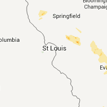
Hail Map for Sunday, June 5, 2011

Number of Impacted Households on 6/5/2011
0
Impacted by 1" or Larger Hail
0
Impacted by 1.75" or Larger Hail
0
Impacted by 2.5" or Larger Hail
Square Miles of Populated Area Impacted on 6/5/2011
0
Impacted by 1" or Larger Hail
0
Impacted by 1.75" or Larger Hail
0
Impacted by 2.5" or Larger Hail


Cities Most Affected by Hail Storms of 6/5/2011
| Hail Size | Demographics of Zip Codes Affected | ||||||
|---|---|---|---|---|---|---|---|
| City | Count | Average | Largest | Pop Density | House Value | Income | Age |
| Sparta, WI | 3 | 2.00 | 2.50 | 69 | $78k | $37.4k | 39.6 |
| Loganville, WI | 1 | 4.25 | 4.25 | 20 | $83k | $41.3k | 41.0 |
| Tomah, WI | 2 | 2.13 | 2.50 | 103 | $82k | $38.3k | 39.8 |
| Reedsburg, WI | 2 | 2.13 | 2.50 | 125 | $99k | $42.0k | 38.6 |
| North Freedom, WI | 1 | 2.75 | 2.75 | 28 | $85k | $41.3k | 37.3 |
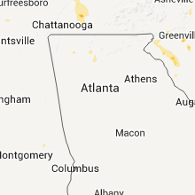
| Taylors, SC | 1 | 1.75 | 1.75 | 878 | $106k | $43.0k | 37.8 |
| Litchfield, IL | 1 | 1.75 | 1.75 | 83 | $61k | $31.5k | 42.4 |
| Baraboo, WI | 1 | 1.75 | 1.75 | 153 | $103k | $40.9k | 39.8 |
| Eustace, TX | 1 | 1.75 | 1.75 | 51 | $64k | $35.7k | 42.4 |
| Joanna, SC | 1 | 1.75 | 1.75 | 312 | $48k | $28.7k | 40.0 |
Hail and Wind Damage Spotted on 6/5/2011
Filter by Report Type:Hail ReportsWind Reports
States Impacted
Illinois, South Carolina, Indiana, Kentucky, Arkansas, Tennessee, Alabama, Mississippi, North Carolina, Louisiana, Texas, Virginia, Ohio, Georgia, Pennsylvania, Florida, California, Minnesota, WisconsinIllinois
| Local Time | Report Details |
|---|---|
| 12:08 PM UTC | Golf Ball sized hail reported near Litchfield, IL, 50 miles NE of Saint Louis, MO, on route 60 between litchfield and hillsboro. |
South Carolina
| Local Time | Report Details |
|---|---|
| 12:51 PM UTC | Reported through wfo charleston. a pilot reported part of a room torn off at a building along huger stree in richland county SC, 64.3 miles ENE of Augusta, GA |
| 12:53 PM UTC | Sheriff dispatch reported trees down at the intersection of rosewood drive and assembly stree in richland county SC, 64.9 miles ENE of Augusta, GA |
| 1:27 PM UTC | Highway patrol reported a tree down a glenn avenue and ryan stree in richland county SC, 65.8 miles NE of Augusta, GA |
| 1:31 PM UTC | Highway patrol reported a tree down along highway 12 at the congaree river bridg in richland county SC, 64.2 miles NE of Augusta, GA |
| 8:45 PM UTC | Tree blocking the roadway at ghost valley road and rainbow lake roa in spartanburg county SC, 40 miles ENE of Greenville, SC |
| 8:48 PM UTC | Tree down across the roadway at 590 antioch roa in cherokee county SC, 36.1 miles W of Charlotte, NC |
| 8:56 PM UTC | Trees down and metal roof off picnic shelter in cherokee county SC, 38 miles W of Charlotte, NC |
| 9:00 PM UTC | Trees and power lines down near hwy 9 and rainbow lake r in spartanburg county SC, 39.1 miles ENE of Greenville, SC |
| 9:05 PM UTC | Tree down across the roadway near mile marker 102 on i-8 in cherokee county SC, 38.6 miles W of Charlotte, NC |
| 9:15 PM UTC | Spartanburg county reports one tree down at the intersection of oakview drive and pineneedle driv in spartanburg county SC, 38.8 miles ENE of Greenville, SC |
| 9:30 PM UTC | Tree knocked down power lines. many large branches dow in pickens county SC, 9.7 miles N of Greenville, SC |
| 9:42 PM UTC | Trees down and snapped off in several locations in croft state par in spartanburg county SC, 43.8 miles E of Greenville, SC |
| 9:56 PM UTC | Ping Pong Ball sized hail reported near Taylors, SC, 17.6 miles ENE of Greenville, SC |
| 10:00 PM UTC | Golf Ball sized hail reported near Taylors, SC, 17.6 miles ENE of Greenville, SC, update to the previous ping pong ball sized report. occurred on edwards road in taylors. |
| 10:04 PM UTC | Tree blocking the roadway at e north street and mitchell roa in greenville county SC, 14.6 miles ENE of Greenville, SC |
| 10:08 PM UTC | Tree blocking the roadway at brown drive and five forks roa in greenville county SC, 19.6 miles E of Greenville, SC |
| 10:10 PM UTC | Large trees down and blocking the roadwa in laurens county SC, 26.2 miles ESE of Greenville, SC |
| 10:16 PM UTC | Tree blocking the roadway at durbin church road and gentry roa in laurens county SC, 29.8 miles ESE of Greenville, SC |
| 10:18 PM UTC | Two large trees blocking the roadway on lawson road in the monarch mills area of union count in union county SC, 54.1 miles SW of Charlotte, NC |
| 10:20 PM UTC | Large branches down on woodruff road...just south of hw-1 in greenville county SC, 19.9 miles E of Greenville, SC |
| 10:25 PM UTC | Quarter sized hail reported near West Union, SC, 23.3 miles W of Greenville, SC, in the 300 block of falcons nest road. |
| 10:27 PM UTC | Tree blocking the roadway at sc-92 and postell hughes roa in laurens county SC, 32.3 miles ESE of Greenville, SC |
| 10:30 PM UTC | Tree blocking the roadway at abner creek road and snow roa in spartanburg county SC, 26.2 miles E of Greenville, SC |
| 10:30 PM UTC | Quarter sized hail reported near Simpsonville, SC, 24.4 miles ESE of Greenville, SC, two instances of hail at this location. the first was nickel sized at 615 pm and the second was quarter sized at 630 pm. |
| 10:40 PM UTC | Tree blocking the roadway at old seneca road in the clemson forest are in pickens county SC, 15 miles WSW of Greenville, SC |
| 10:56 PM UTC | Tree blocking the roadway at a b jacks road and mill creek roa in laurens county SC, 44.7 miles ESE of Greenville, SC |
| 10:58 PM UTC | Tree blocking the roadway at the 1200 block of torrington roa in laurens county SC, 45.8 miles ESE of Greenville, SC |
| 11:00 PM UTC | Tree blocking the roadway at stateline road and sc-27 in york county SC, 16.2 miles WSW of Charlotte, NC |
| 11:00 PM UTC | Quarter sized hail reported near Clinton, SC, 48 miles ESE of Greenville, SC, on dillon drive. |
| 11:03 PM UTC | Tree blocking the roadway at sc-49 and sc-27 in york county SC, 18.7 miles SW of Charlotte, NC |
| 11:09 PM UTC | Tree blocking the roadway at sutton spring road and kelly roa in york county SC, 27.7 miles WSW of Charlotte, NC |
| 11:11 PM UTC | Tree blocking the roadway at sc-49 and clegg farm roa in york county SC, 20.6 miles WSW of Charlotte, NC |
| 11:15 PM UTC | Tree blocking the roadway at jefferson davis road and sc-5 in laurens county SC, 52 miles SE of Greenville, SC |
| 11:20 PM UTC | Tree blocking the roadway at the intersection of magnum branch road and sc-23 in york county SC, 27.4 miles SW of Charlotte, NC |
| 11:24 PM UTC | Tree blocking the roadway at sc-324 and boxwood cour in york county SC, 27.4 miles SW of Charlotte, NC |
| 11:28 PM UTC | Tree blocking the roadway at allison circle and sc-27 in york county SC, 21 miles SW of Charlotte, NC |
| 11:32 PM UTC | Tree blocking the roadway at pea creek road and us-7 in anderson county SC, 23.8 miles S of Greenville, SC |
| 11:35 PM UTC | Highway patrol reports a tree down on bush river roa in newberry county SC, 57.3 miles SE of Greenville, SC |
| 11:37 PM UTC | Sheriff dispatch reported trees down in the bush river road are in newberry county SC, 59.3 miles NNE of Augusta, GA |
| 11:43 PM UTC | Quarter sized hail reported near Belton, SC, 25.5 miles SSE of Greenville, SC, flattened corn |
| 11:47 PM UTC | Quarter sized hail reported near Richburg, SC, 36.2 miles SSW of Charlotte, NC, dime to quarter size hail |
| 12:20 AM UTC | Trees down on carolina circl in abbeville county SC, 46.6 miles SSE of Greenville, SC |
| 12:20 AM UTC | Trees down on stephenson roa in abbeville county SC, 45.3 miles SSE of Greenville, SC |
| 12:20 AM UTC | Public reported shingles blown from roof of house along brewington road. wind estimated around 60 mp in clarendon county SC, 40.5 miles N of Charleston, SC |
| 12:35 AM UTC | Two trees down near hwy 76 and secondary 46 and torrington road on edge of clinton city limits. few other limbs dow in laurens county SC, 47.6 miles ESE of Greenville, SC |
| 12:36 AM UTC | Sheriff dispatch reported a tree down at marley driv in richland county SC, 64.8 miles NE of Augusta, GA |
| 12:41 AM UTC | Highway patrol reported a tree down at i-126 and greystone boulevar in richland county SC, 63.2 miles NE of Augusta, GA |
| 12:45 AM UTC | Trees and limbs down hwy 28 near hwy 20 nw of abbevill in abbeville county SC, 45.8 miles SSE of Greenville, SC |
| 12:45 AM UTC | Golf Ball sized hail reported near Joanna, SC, 53.2 miles ESE of Greenville, SC |
| 12:53 AM UTC | Sheriff dispatch reported a tree down on a house at florida s in richland county SC, 64.5 miles ENE of Augusta, GA |
| 1:10 AM UTC | Highway patrol reported tree in the roadway at cedar creek road and monticello roa in richland county SC, 69 miles NE of Augusta, GA |
| 1:11 AM UTC | Highway patrol reported a tree down at cedar creek road adn blume roa in richland county SC, 69.8 miles NE of Augusta, GA |
| 1:17 AM UTC | Powerlines down in roadway. pond branch rd and caulks ferry rd are in lexington county SC, 46 miles NE of Augusta, GA |
| 1:20 AM UTC | Trees in roadway. caulks ferry rd. and water tank r in lexington county SC, 43.3 miles ENE of Augusta, GA |
| 1:36 AM UTC | Tree in roadway. i-126 at greystone blv in richland county SC, 63.2 miles NE of Augusta, GA |
Indiana
| Local Time | Report Details |
|---|---|
| 3:20 PM UTC | Storm damage reported in vanderburgh county IN, 7.9 miles N of Evansville, IN |
| 3:30 PM UTC | Quarter sized hail reported near Evansville, IN, 1.3 miles E of Evansville, IN, up to quarter size hail on the west side of evansville. from channel 14. |
| 3:37 PM UTC | Reports of power lines down in the 1200 block of south harlen ave. and bellemeade ave. relayed by weh in vanderburgh county IN, 1.3 miles E of Evansville, IN |
Kentucky
| Local Time | Report Details |
|---|---|
| 4:02 PM UTC | Storm damage reported in daviess county KY, 22.4 miles SSE of Evansville, IN |
| 4:05 PM UTC | Tree limbs down in owensboro near cravens elementary school. estimated 45 mph wind in daviess county KY, 28.5 miles ESE of Evansville, IN |
| 4:11 PM UTC | Relayed by channel 1 in daviess county KY, 28.5 miles ESE of Evansville, IN |
| 4:30 PM UTC | Small trees of 2-3 inches in diameter snappe in hopkins county KY, 55.1 miles S of Evansville, IN |
| 4:35 PM UTC | Numerous trees down - power lines down in muhlenberg county KY, 52.4 miles SSE of Evansville, IN |
| 4:46 PM UTC | Large trees and power lines down. estimated wind gust to 72 mp in muhlenberg county KY, 52.4 miles SSE of Evansville, IN |
| 4:53 PM UTC | Tree has fallen on a house in ohio county KY, 48.5 miles SE of Evansville, IN |
| 4:58 PM UTC | Tree down in rochester in butler county KY, 64.5 miles SE of Evansville, IN |
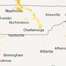
| 5:40 PM UTC | Numerous trees down in bowling green and a wendys sign blown down in warren county KY, 58.4 miles NNE of Nashville, TN |
| 5:50 PM UTC | Quarter sized hail reported near Bowling Green, KY, 58.4 miles NNE of Nashville, TN |
| 5:54 PM UTC | Numerous power outages across the city in warren county KY, 58.4 miles NNE of Nashville, TN |
| 5:54 PM UTC | Large barn had part of roof blown off. also had tree damage nearb in warren county KY, 53.4 miles NNE of Nashville, TN |
| 5:58 PM UTC | Storm damage reported in warren county KY, 53.8 miles NNE of Nashville, TN |
| 5:58 PM UTC | Quarter sized hail reported near Bowling Green, KY, 53.8 miles NNE of Nashville, TN |
| 6:26 PM UTC | Numerous trees and power lines down in the city and the surrounding are in allen county KY, 51.5 miles NE of Nashville, TN |
Arkansas
| Local Time | Report Details |
|---|---|
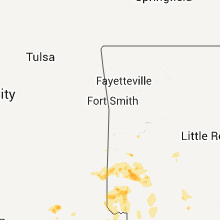
| 5:58 PM UTC | Quarter sized hail reported near Wickes, AR, 40.8 miles NW of Nashville, AR |
| 7:25 PM UTC | Trees reported down north of the center point area...as well as in between muddy fork and dierk in howard county AR, 12.4 miles NW of Nashville, AR |
| 8:10 PM UTC | Trees down in star city and pea size hai in lincoln county AR, 61 miles SSE of Little Rock, AR |
| 8:20 PM UTC | Tree blown over by thunderstorm wind in little river county AR, 22.6 miles SW of Nashville, AR |
| 8:25 PM UTC | Trees down in city of hot springs...including on hamilton drive and malvern roa in garland county AR, 47.7 miles WSW of Little Rock, AR |
| 8:30 PM UTC | Trees and large limbs down in the town of hop in hempstead county AR, 24.2 miles SE of Nashville, AR |
| 8:59 PM UTC | Quarter sized hail reported near Hot Springs National Park, AR, 42.4 miles WSW of Little Rock, AR, spotter reported penny to quarter size hail northeast of fountain lake. |
| 9:13 PM UTC | Storm damage reported in miller county AR, 35.7 miles SSW of Nashville, AR |
| 9:20 PM UTC | Trees down on highway 5 north at danville roa in garland county AR, 45.9 miles WSW of Little Rock, AR |
| 9:25 PM UTC | *** 1 fatal *** a tree fell on a truck driving along park avenue in the northeast part of hot springs. the driver was killed...and was the only occupant in the vehicl in garland county AR, 44.8 miles WSW of Little Rock, AR |
| 9:25 PM UTC | Trees down on park avenue northeast of downtow in garland county AR, 44 miles WSW of Little Rock, AR |
| 9:34 PM UTC | Trees and powerlines down in the fouke are in miller county AR, 47.5 miles S of Nashville, AR |
| 9:55 PM UTC | Three houses with roof damage on shepard street in east camden. also...a large trampoline was wrapped around a power pol in ouachita county AR, 67.8 miles ESE of Nashville, AR |
| 9:55 PM UTC | Trees down and shingles off roof in east camde in ouachita county AR, 67.8 miles ESE of Nashville, AR |
| 10:40 PM UTC | Roof damage to a house...along with tree limbs on vehicles...and power lines on road in ouachita county AR, 63 miles ESE of Nashville, AR |
| 10:40 PM UTC | Trees down in the city of camde in ouachita county AR, 63 miles ESE of Nashville, AR |
Tennessee
| Local Time | Report Details |
|---|---|
| 6:25 PM UTC | Trees and signs blown down near heritage high schoo in robertson county TN, 26.2 miles NNE of Nashville, TN |
| 6:55 PM UTC | Numerous trees down across western macon county. possible tornado 6 miles nnw of lafayette at the scotsville and shiloh road intersectio in macon county TN, 49.5 miles NE of Nashville, TN |
| 7:04 PM UTC | Brush creek area large branches broken in smith county TN, 41.8 miles E of Nashville, TN |
| 7:10 PM UTC | Small trees and limbs in davidson county TN, 6.5 miles SW of Nashville, TN |
| 7:21 PM UTC | Large branches broken in putnam county TN, 70.9 miles E of Nashville, TN |
| 7:45 PM UTC | Quarter sized hail reported near Gainesboro, TN, 70.4 miles ENE of Nashville, TN, quarter size hail reported by public on highway 85 northeast of gainesboro. |
| 7:50 PM UTC | Trees down with damage in various places in jackson county. marble sized hail in gainsbor in jackson county TN, 64.4 miles ENE of Nashville, TN |
| 7:54 PM UTC | Home damaged at 481 brittsbill road in the georgetown community. also...several trees down on and around brittsbill road. reported by dispatc in meigs county TN, 30.8 miles NE of Chattanooga, TN |
| 7:54 PM UTC | Home damaged at 481 brittsbill road in the georgetown community. several trees down on and around brittsbill road as well. reported by dispatch in meigs county TN, 30.8 miles NE of Chattanooga, TN |
| 8:20 PM UTC | Quarter sized hail reported near Cleveland, TN, 33.1 miles ENE of Chattanooga, TN, quarter sized hail on and around walker valley road. reported by dispatch. |
| 8:30 PM UTC | Trees down along the bradley-polk county-lin in polk county TN, 36.4 miles ENE of Chattanooga, TN |
| 8:40 PM UTC | Trees down county wide. damage to homes in pikevill in bledsoe county TN, 39.3 miles N of Chattanooga, TN |
| 8:44 PM UTC | Quarter sized hail reported near Tullahoma, TN, 55.9 miles WNW of Chattanooga, TN |
| 8:44 PM UTC | Quarter sized hail reported near Crossville, TN, 58.2 miles NNE of Chattanooga, TN, cocorahs sig wx rpt |
| 8:45 PM UTC | Large tree down on power lines in the old fort communit in polk county TN, 34 miles E of Chattanooga, TN |
| 8:46 PM UTC | On highway 30 near old georgetown...wind gusts estimated at 70 mph. many tree limbs down on the highway and heavy rain. reported by spotte in meigs county TN, 43.7 miles NE of Chattanooga, TN |
| 9:14 PM UTC | Several homes damaged and numerous trees down on county route 100. reported by spotte in mcminn county TN, 43 miles NE of Chattanooga, TN |
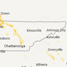
| 9:30 PM UTC | A few trees and powerlines down countywide. reported by dispatc in hamilton county TN, 15 miles NE of Chattanooga, TN |
| 9:45 PM UTC | A few trees down between madisonville and telico plain in monroe county TN, 39.9 miles SW of Knoxville, TN |
| 9:50 PM UTC | Several trees dow in washington county TN, 25.3 miles SW of Bristol, TN |
| 10:50 PM UTC | A trees down near erwi in unicoi county TN, 32.9 miles SSW of Bristol, TN |
| 11:00 PM UTC | A few trees down near telico plain in monroe county TN, 46 miles SSW of Knoxville, TN |
| 11:25 PM UTC | Tree down on car in washington county TN, 19.9 miles SSW of Bristol, TN |
| 11:28 PM UTC | Several trees and power lines dow in washington county TN, 19.9 miles SSW of Bristol, TN |
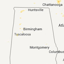
Alabama
| Local Time | Report Details |
|---|---|
| 6:36 PM UTC | Power lines blown down on grand view avenu in colbert county AL, 3.8 miles E of Florence, AL |
| 6:36 PM UTC | A tree was blown down on 600 block of columbia avenu in colbert county AL, 3.1 miles SSW of Florence, AL |
| 6:36 PM UTC | Trees and power lines blown dow in colbert county AL, 3.1 miles SSW of Florence, AL |
| 6:40 PM UTC | Trees and power lines down hwy 101/72 in lauderdale county AL, 16.6 miles ENE of Florence, AL |
| 6:40 PM UTC | Power lines down. pea to marble size hai in colbert county AL, 4.2 miles S of Florence, AL |
| 6:40 PM UTC | Mitchell blvd. power lines down and penny size hai in colbert county AL, 2.5 miles SSW of Florence, AL |
| 6:45 PM UTC | Driving range building destroyed on woodward avenu in colbert county AL, 4.2 miles S of Florence, AL |
| 6:45 PM UTC | Quarter sized hail reported near Muscle Shoals, AL, 4.2 miles S of Florence, AL, penny to quarter sized hail reported in muscle shoals. |
| 6:48 PM UTC | A tree was blown down onto a traile in colbert county AL, 5.1 miles SSE of Florence, AL |
| 7:06 PM UTC | A tree was blown down onto powerlines on river driv in colbert county AL, 6.7 miles SSW of Florence, AL |
| 8:35 PM UTC | Strong straightline downburst winds damaged about a dozen homes. one home had nearly all the shingles blown off...the other homes received minor roof damage.tree limbs in monroe county AL, 50.7 miles SSW of Camden, AL |
| 9:00 PM UTC | A few trees were blown down near the intersection of highway 18 and county road 8 in fayette county AL, 57.1 miles WNW of Birmingham, AL |
| 9:47 PM UTC | Half Dollar sized hail reported near Berry, AL, 47.4 miles W of Birmingham, AL, silver dollar size hail reported near samantha. |
| 11:45 PM UTC | Ping Pong Ball sized hail reported near Tallassee, AL, 24 miles W of Auburn, AL, reported near yates dam |
| 11:45 PM UTC | Ping Pong Ball sized hail reported near Dadeville, AL, 19.8 miles WNW of Auburn, AL |
Mississippi
| Local Time | Report Details |
|---|---|
| 7:26 PM UTC | Quarter sized hail reported near Moss Point, MS, 28 miles W of Mobile, AL, quarter sized hail was reported in hurley. |
| 7:30 PM UTC | Several trees were downed along the pearl river near pipeline r in madison county MS, 24.3 miles NE of Jackson, MS |
| 7:45 PM UTC | A few lines down along with many limb in clay county MS, 14.2 miles ENE of Starkville, MS |
| 8:57 PM UTC | Several trees and power lines down in washington county MS, 72.8 miles NE of Bastrop, LA |
| 9:10 PM UTC | Trees were downed along n chapel hill rd...partially blocking the roa in hinds county MS, 17.6 miles W of Jackson, MS |
| 9:10 PM UTC | Trees were downed near the intersection of state highway 467 and n chapel hill rd...partially blocking the roa in hinds county MS, 17.5 miles W of Jackson, MS |
| 9:20 PM UTC | Quarter sized hail reported near Greenville, MS, 66.5 miles ENE of Bastrop, LA |
| 9:28 PM UTC | A few lines down along with many limb in clay county MS, 14.2 miles NNE of Starkville, MS |
| 9:31 PM UTC | Quarter sized hail reported near Hollandale, MS, 64.3 miles ENE of Bastrop, LA, strong winds also occurred with power out. |
| 10:15 PM UTC | A few trees down on honeysucker rd near hwy 4 in madison county MS, 38.2 miles NE of Jackson, MS |
| 10:28 PM UTC | A few trees down off robinson r in madison county MS, 25.3 miles NNE of Jackson, MS |
| 10:42 PM UTC | A few trees down with the top bown out of a tree. numerous large limbs down and blocking the road. a trampoline was also thrown across the yard into a garde in kemper county MS, 50.5 miles S of Starkville, MS |
| 1:08 AM UTC | A few trees down in tylertow in walthall county MS, 80.4 miles N of New Orleans, LA |
North Carolina
| Local Time | Report Details |
|---|---|
| 7:47 PM UTC | Quarter sized hail reported near Rutherfordton, NC, 48.3 miles NE of Greenville, SC, penny to quarter sized hail at the river creek campground. |
| 8:33 PM UTC | Spotter reports that a wooden shutter was blown off a home and damaged two nearby vehicle in cleveland county NC, 34.7 miles W of Charlotte, NC |
| 8:35 PM UTC | Tree down across road at 831 longbranch road in cleveland county NC, 34.4 miles W of Charlotte, NC |
| 8:35 PM UTC | Tree down across road at 831 longbranch road in cleveland county NC, 35.8 miles W of Charlotte, NC |
| 8:38 PM UTC | Tree across road at 344 runyan road in cleveland county NC, 38 miles W of Charlotte, NC |
| 8:40 PM UTC | Trees and power lines down 1203 lavender road in cleveland county NC, 37 miles W of Charlotte, NC |
| 8:50 PM UTC | One tree down on antietam roa in iredell county NC, 44.5 miles NNW of Charlotte, NC |
| 8:50 PM UTC | Several trees down on lippard farm rd in iredell county NC, 43.7 miles NNW of Charlotte, NC |
| 9:00 PM UTC | Trees and power lines down near hwy 9 and rainbow lake r in cleveland county NC, 46 miles W of Charlotte, NC |
| 9:05 PM UTC | Trees down east of lake lure near green hil in rutherford county NC, 50 miles NNE of Greenville, SC |
| 5:48 PM EDT | Multiple trees down...with some on structures...along hw-150 near the lincoln...catawba county lin in catawba county NC, 25.7 miles NNW of Charlotte, NC |
| 9:55 PM UTC | Quarter sized hail reported near Southport, NC, 21.9 miles SSW of Wilmington, NC |
| 10:01 PM UTC | Quarter sized hail reported near Winnabow, NC, 11.9 miles SW of Wilmington, NC |
| 10:10 PM UTC | Quarter sized hail reported near Marshall, NC, 58.8 miles SSW of Bristol, TN |
| 10:25 PM UTC | Large limbs dow in gaston county NC, 34.1 miles WNW of Charlotte, NC |
| 10:30 PM UTC | Several small trees and limbs down on riddle farm r in madison county NC, 59.8 miles SSW of Bristol, TN |
| 10:40 PM UTC | Public reports numerous trees down around mcadenville...many blocking roadways. one tree is also down at mcadenville elementary school. much of the damage is along hw-7 in gaston county NC, 14 miles W of Charlotte, NC |
| 6:43 PM EDT | Quarter sized hail reported near McAdenville, NC, 13.4 miles W of Charlotte, NC, at the intersection of reese street and bartlett street. |
| 10:51 PM UTC | Multiple large tree limbs down...5 inches in diameter...near the intersection of edgewater drive and paradise driv in gaston county NC, 12.6 miles W of Charlotte, NC |
| 2:01 AM UTC | Tree down on blue ridge parkway at the intersection of route 1 in alleghany county NC, 56.4 miles ESE of Bristol, TN |
Louisiana
| Local Time | Report Details |
|---|---|
| 8:40 PM UTC | Trees down and part of a tin roof blown into the r in richland county LA, 37.1 miles S of Bastrop, LA |
| 8:45 PM UTC | Camp house roof torn off and numerous trees down near hebert la in caldwell county LA, 41.4 miles S of Bastrop, LA |
| 8:52 PM UTC | A couple trees down...one across a r in richland county LA, 29 miles S of Bastrop, LA |
| 10:52 PM UTC | Quarter sized hail reported near Central, LA, 66.1 miles ENE of Lafayette, LA, quarter size hail reported by off duty nws forecaster. |
| 12:00 AM UTC | Trees and power lines down across at least 10 locations within the city of shreveport and the surrounding areas of the paris in caddo county LA, 4.3 miles SW of Shreveport, LA |
Texas
| Local Time | Report Details |
|---|---|
| 9:12 PM UTC | Emergency manager reported roof damage to 2 houses...one barn destroyed and damage to a television tower in chapel hil in washington county TX, 60.5 miles WNW of Houston, TX |
| 9:17 PM UTC | Trees down between marietta and linden...including 20 inch diameter pine blocking roadwa in cass county TX, 53 miles NW of Shreveport, LA |
| 9:30 PM UTC | Shi in montgomery county TX, 38.5 miles NW of Houston, TX |
| 4:33 PM CDT | Trees down in northern waller count in waller county TX, 44.1 miles NW of Houston, TX |
| 9:40 PM UTC | Tree blown down across fm 1130 northeast of linde in cass county TX, 49.6 miles NW of Shreveport, LA |
| 9:50 PM UTC | Quarter sized hail reported near Ganado, TX, 84.8 miles SW of Houston, TX, quarter size hail in ganado with mostly penny size hail. |
| 10:00 PM UTC | Tree down on elm street. large limbs down on power lines throughout the cit in cass county TX, 48.1 miles NNW of Shreveport, LA |
| 10:20 PM UTC | Downed trees falling on power lines in edn in jackson county TX, 92.9 miles NNE of Corpus Christi, TX |
| 10:20 PM UTC | Trees reported down on numerous county roads near pittsbur in camp county TX, 77.3 miles WNW of Shreveport, LA |
| 10:30 PM UTC | Trampoline staked with rebar 2 feet into the ground lifted and thrown onto roof of house. also dead tree blowdown and pea size hai in lee county TX, 77.4 miles SE of Killeen, TX |
| 10:33 PM UTC | Trees down at westpark and gessne in harris county TX, 14.7 miles W of Houston, TX |
| 10:35 PM UTC | Tree reported down in mt. pleasant due to thunderstorm wind in titus county TX, 84.5 miles SW of Nashville, AR |
| 10:35 PM UTC | Roof damage to an apartment complex near ranchester and harwin. bricks and windows blown ou in harris county TX, 14.5 miles WSW of Houston, TX |
| 5:36 PM CDT | Windows blown out at the verizon call center on corporate and town par in harris county TX, 14.7 miles WSW of Houston, TX |
| 10:40 PM UTC | Golf Ball sized hail reported near Eustace, TX, 57.9 miles SE of Dallas, TX, few quarter to golfball hail stones in eustace. also possible damaging winds in payne springs. |
| 10:55 PM UTC | Trees downed in mission bend with estimated 61 mph wind gust by trained storm spotte in fort bend county TX, 18.1 miles WSW of Houston, TX |
| 10:55 PM UTC | Trees reported dow in wood county TX, 78.9 miles E of Dallas, TX |
| 11:20 PM UTC | Several trees down near tyler...as well as near lindal in smith county TX, 76.2 miles NNW of Lufkin, TX |
| 6:40 PM CDT | Numerous power poles snapped at base...street signs down...roofs off 2 houses...numerous trees down. scattered damage from crosby to lake houston dam along fm 210 in harris county TX, 19.4 miles NE of Houston, TX |
| 6:50 PM CDT | Roof damage to businesses and trees down in atascocita off will clayton pkwy/west lake houston pkw in harris county TX, 18.6 miles NE of Houston, TX |
| 7:14 PM CDT | High winds downed power lines in east bernar in wharton county TX, 44.5 miles WSW of Houston, TX |
| 12:58 AM UTC | Quarter sized hail reported near Bruceville-Eddy, TX, 32.6 miles ENE of Killeen, TX, quarter size hail in bruceville-eddy |
| 2:05 AM UTC | Possible microburst 5 miles northwest of oglesby in coryell county TX, 25.8 miles NNE of Killeen, TX |
Virginia
| Local Time | Report Details |
|---|---|
| 9:30 PM UTC | Quarter sized hail reported near Covington, VA, 35.1 miles N of Roanoke, VA |
| 10:52 PM UTC | 18 inch diamter tree uprooted on the 8300 block of barrens rd in roanoke county VA, 5.7 miles NNW of Roanoke, VA |
| 10:52 PM UTC | 8 inch diameter tree down at the intersection of barrens rd and laban rd in roanoke county VA, 5.7 miles NNW of Roanoke, VA |
| 10:52 PM UTC | Quarter sized hail reported near Roanoke, VA, 5.7 miles NNW of Roanoke, VA, hail began 652 pm and fell intermittently through 700 pm. |
| 11:05 PM UTC | Quarter sized hail reported near Roanoke, VA, 3.3 miles N of Roanoke, VA |
| 11:30 PM UTC | Tree down near va medical cente in city of roanoke county VA, 4.4 miles W of Roanoke, VA |
Ohio
| Local Time | Report Details |
|---|---|
| 10:23 PM UTC | Ping Pong Ball sized hail reported near New Holland, OH, 27.7 miles SSW of Columbus, OH, reported just south of deer creek lake. |
Georgia
| Local Time | Report Details |
|---|---|
| 10:35 PM UTC | Emergency manager reports that about a dozen trees were down between talking rock and the cherokee county line. some pea-sized hail was observed in the far western part in pickens county GA, 44.8 miles N of Atlanta, GA |
| 10:35 PM UTC | Emergency manager reports that about a dozen trees were down. some pea-sized hail was observed in the far western part of the count in pickens county GA, 44.8 miles N of Atlanta, GA |
Pennsylvania
| Local Time | Report Details |
|---|---|
| 11:30 PM UTC | Large branches down in northumberland county PA, 57.5 miles SW of Scranton, PA |
| 11:40 PM UTC | Trees down in schuylkill county PA, 57.7 miles SW of Scranton, PA |
| 1:01 AM UTC | Quarter sized hail reported near Ephrata, PA, 65.5 miles NNE of Baltimore, MD |
Florida
| Local Time | Report Details |
|---|---|
| 12:25 AM UTC | Seven trees reported down across the county. one car damaged by a fallen tree. over 10000 residents without power...mostly west of meridian road and north of tennessee in leon county FL, 0 miles ENE of Tallahassee, FL |
| 12:25 AM UTC | A few trees reported down across the county. time estimated by rada in leon county FL, 0 miles ENE of Tallahassee, FL |
| 12:40 AM UTC | Several trees down on the south side of doak campbell stadiu in leon county FL, 0 miles ENE of Tallahassee, FL |
California
| Local Time | Report Details |
|---|---|
| 5:30 AM UTC | Tree down in center divider of north 11th avenue just north of west lacey blv in kings county CA, 29.3 miles SSE of Fresno, CA |
Minnesota
| Local Time | Report Details |
|---|---|
| 7:20 AM UTC | Quarter sized hail reported near West Concord, MN, 60.7 miles SSE of Minneapolis, MN, hail lasted for approx 10 minutes. |
Wisconsin
| Local Time | Report Details |
|---|---|
| 8:49 AM UTC | Quarter sized hail reported near Holmen, WI, 17.1 miles N of La Crosse, WI |
| 10:00 AM UTC | Golf Ball sized hail reported near Reedsburg, WI, 43.6 miles NW of Madison, WI, delayed report. time estimated. hood and roof damage to parked vehicles. |
| 10:23 AM UTC | Golf Ball sized hail reported near Sparta, WI, 25.7 miles ENE of La Crosse, WI |
| 10:25 AM UTC | Golf Ball sized hail reported near Sparta, WI, 31.9 miles ENE of La Crosse, WI |
| 10:35 AM UTC | Tennis Ball sized hail reported near Sparta, WI, 31.9 miles ENE of La Crosse, WI |
| 10:40 AM UTC | Grapefruit sized hail reported near Loganville, WI, 41.6 miles NW of Madison, WI, estimated hail stone of 4.25 inches based on pictures relayed from wmtv-15 of madison. a viewer in loganville took the pictures. time is estimated based on other report |
| 10:42 AM UTC | Tennis Ball sized hail reported near Reedsburg, WI, 47.1 miles NW of Madison, WI, near intersection of thomas road and county highway k. |
| 10:45 AM UTC | Tennis Ball sized hail reported near Tomah, WI, 34.6 miles E of La Crosse, WI |
| 10:45 AM UTC | Grapefruit sized hail reported near , , 43.7 miles NW of Madison, WI, report based on photo submitted to nbc-15 madison. time estimated. size estimated based on size of adult hand. |
| 10:48 AM UTC | Golf Ball sized hail reported near Tomah, WI, 38.2 miles E of La Crosse, WI, lasted for 10 to 15 minutes. |
| 11:00 AM UTC | Baseball sized hail reported near North Freedom, WI, 34.8 miles NW of Madison, WI |
| 11:35 AM UTC | Golf Ball sized hail reported near Baraboo, WI, 31.5 miles NW of Madison, WI |
| 11:45 AM UTC | Quarter sized hail reported near New Lisbon, WI, 58.6 miles E of La Crosse, WI |
Connect with Interactive Hail Maps