

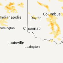
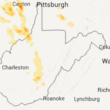
Hail Map for Saturday, June 4, 2011

Number of Impacted Households on 6/4/2011
0
Impacted by 1" or Larger Hail
0
Impacted by 1.75" or Larger Hail
0
Impacted by 2.5" or Larger Hail
Square Miles of Populated Area Impacted on 6/4/2011
0
Impacted by 1" or Larger Hail
0
Impacted by 1.75" or Larger Hail
0
Impacted by 2.5" or Larger Hail


Cities Most Affected by Hail Storms of 6/4/2011
| Hail Size | Demographics of Zip Codes Affected | ||||||
|---|---|---|---|---|---|---|---|
| City | Count | Average | Largest | Pop Density | House Value | Income | Age |
| Beacon, IA | 2 | 1.88 | 2.00 | 496 | $46k | $28.2k | 38.0 |
| Massillon, OH | 2 | 1.75 | 1.75 | 1654 | $106k | $41.5k | 40.7 |
| Canton, OH | 2 | 1.75 | 1.75 | 863 | $74k | $28.8k | 38.0 |
| Plainfield, IL | 2 | 1.75 | 1.75 | 1175 | $170k | $70.4k | 37.1 |
| Oskaloosa, IA | 1 | 2.00 | 2.00 | 92 | $69k | $36.7k | 38.4 |
| Augusta, IL | 1 | 1.75 | 1.75 | 13 | $37k | $36.3k | 43.6 |
| Manhattan, IL | 1 | 1.75 | 1.75 | 137 | $171k | $62.9k | 33.7 |
| Tinley Park, IL | 1 | 1.75 | 1.75 | 3036 | $168k | $62.0k | 40.7 |
| Tipton, IN | 1 | 1.75 | 1.75 | 82 | $87k | $46.2k | 42.9 |
| Fowler, IL | 1 | 1.75 | 1.75 | 39 | $78k | $45.2k | 41.9 |
| Circleville, OH | 1 | 1.75 | 1.75 | 143 | $106k | $40.9k | 41.0 |
| Plymouth, IL | 1 | 1.75 | 1.75 | 10 | $25k | $33.6k | 39.9 |
| Erie, PA | 1 | 1.75 | 1.75 | 4520 | $40k | $21.9k | 27.2 |
| Dover, OH | 1 | 1.75 | 1.75 | 341 | $99k | $39.3k | 43.7 |
| Lewisburg, WV | 1 | 1.75 | 1.75 | 101 | $116k | $29.3k | 45.0 |
Hail and Wind Damage Spotted on 6/4/2011
Filter by Report Type:Hail ReportsWind Reports
States Impacted
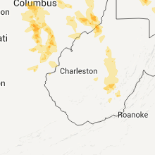
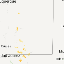
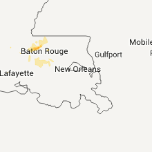
New York, Pennsylvania, Indiana, Illinois, Iowa, Louisiana, Ohio, Missouri, Texas, Arkansas, West VirginiaNew York
| Local Time | Report Details |
|---|---|
| 3:50 PM UTC | Tree down in wright park and memorial park in chautauqua county NY, 34.8 miles SW of Buffalo, NY |
Pennsylvania
| Local Time | Report Details |
|---|---|
| 4:15 PM UTC | Half Dollar sized hail reported near Erie, PA, 80.9 miles SW of Buffalo, NY |
| 12:15 PM EDT | Half Dollar sized hail reported near Erie, PA, 82.7 miles SW of Buffalo, NY, hail was in mill creek. |
| 4:17 PM UTC | Golf Ball sized hail reported near Erie, PA, 80.9 miles SW of Buffalo, NY |
| 4:18 PM UTC | Some trees dow in erie county PA, 80.9 miles SW of Buffalo, NY |
| 4:20 PM UTC | Quarter sized hail reported near Erie, PA, 80.9 miles SW of Buffalo, NY |
| 4:35 PM UTC | Quarter sized hail reported near Waterford, PA, 86 miles SW of Buffalo, NY |
| 4:35 PM UTC | A foot and a half diameter limb fell unto two mobile home in erie county PA, 86 miles SW of Buffalo, NY |
| 4:35 PM UTC | Some trees dow in erie county PA, 86 miles SW of Buffalo, NY |
| 4:40 PM UTC | Some trees dow in erie county PA, 89.1 miles SW of Buffalo, NY |
| 4:45 PM UTC | A tree dow in crawford county PA, 86.8 miles ENE of Cleveland, OH |
| 4:50 PM UTC | One tree down near centervill in crawford county PA, 88.1 miles SSW of Buffalo, NY |
| 4:51 PM UTC | Trees and large branches dow in warren county PA, 73.4 miles S of Buffalo, NY |
| 6:18 PM UTC | Quarter sized hail reported near Perry, PA, 50.4 miles NNE of Pittsburgh, PA |
Indiana
| Local Time | Report Details |
|---|---|
| 5:00 PM UTC | Intermittant power outages in hamilton county IN, 16.1 miles NNE of Indianapolis, IN |
| 8:40 PM UTC | Trees down throughout the city. windows blown out of businesses downtown. time estimated by radar in blackford county IN, 45.4 miles SSW of Fort Wayne, IN |
| 9:14 PM UTC | Quarter sized hail reported near Cutler, IN, 52.3 miles NNW of Indianapolis, IN, in cutler...time estimated from radar. |
| 9:15 PM UTC | Semi blown over. time estimated in lake county IN, 31 miles SSE of Chicago, IL |
| 9:15 PM UTC | Semi blown over. time estimate in lake county IN, 31 miles SSE of Chicago, IL |
| 9:20 PM UTC | Measured via wunderground statio in howard county IN, 49.2 miles N of Indianapolis, IN |
| 5:22 PM EDT | Ping Pong Ball sized hail reported near Kokomo, IN, 49.2 miles N of Indianapolis, IN, near the chrysler plant at 300 n and us 31. |
| 9:23 PM UTC | Nickel size hail also reporte in howard county IN, 49.9 miles N of Indianapolis, IN |
| 9:25 PM UTC | 2 to 3 foot diameter trees downed. pine trees top taken of in lake county IN, 31 miles SSE of Chicago, IL |
| 9:35 PM UTC | Storm damage reported in howard county IN, 49.2 miles N of Indianapolis, IN |
| 9:37 PM UTC | 70 mph gust estimate at 181st and white oak. with pea size hai in lake county IN, 42.6 miles SSE of Chicago, IL |
| 9:40 PM UTC | 40 ft tall tree and billboard down. us 41 and rt in lake county IN, 42.6 miles SSE of Chicago, IL |
| 9:42 PM UTC | 60 mph wind gust accompanied by pea size hail. phone lines down at 400 e and 400 in howard county IN, 44.7 miles N of Indianapolis, IN |
| 9:43 PM UTC | East of the mile 240 exit on i65 a semi was flipped. a weigh scale lost its roof near mile 243. damage was also reported in lowel in lake county IN, 43.8 miles SSE of Chicago, IL |
| 9:44 PM UTC | Storm damage reported in lake county IN, 42.6 miles SSE of Chicago, IL |
| 9:45 PM UTC | Man trees and power lines down down across the southern portion of the count in lake county IN, 42.6 miles SSE of Chicago, IL |
| 9:45 PM UTC | Many trees and power lines down down across the southern portion of the count in lake county IN, 42.6 miles SSE of Chicago, IL |
| 9:45 PM UTC | Many trees and power lines down in southern part of the count in lake county IN, 42.6 miles SSE of Chicago, IL |
| 9:50 PM UTC | 8 foot diameter tree down. time estimated from radar imager in porter county IN, 35.5 miles ESE of Chicago, IL |
| 9:50 PM UTC | Highway 2 from lake into porter county was impassable due to many downed trees and snapped power poles. 50-60 trees were damaged or down in hebron. trees and structures in porter county IN, 44.9 miles SSE of Chicago, IL |
| 10:07 PM UTC | Small branches blown down from breezy point to scarlet oak in carroll county IN, 69.8 miles NNW of Indianapolis, IN |
| 10:10 PM UTC | 6 inch diameter tree branches down and tree blocking lane state rd in porter county IN, 45 miles SSE of Chicago, IL |
| 10:11 PM UTC | Measured at state road 37 and 26 in grant county IN, 50 miles NNE of Indianapolis, IN |
| 10:11 PM UTC | 40 ft tall tree and billboard down. us 41 and rt in lake county IN, 42.6 miles SSE of Chicago, IL |
| 10:16 PM UTC | Power lines down in elwoo in madison county IN, 39 miles NNE of Indianapolis, IN |
| 10:17 PM UTC | Power lines...telephone poles and trees down in elwood. specifically along hwy 128 at 500 w...100 w and 200 w. also on sr 37 north of elwoo in madison county IN, 39 miles NNE of Indianapolis, IN |
| 10:19 PM UTC | Trees and powerlines down across the city in pulaski county IN, 73 miles SSE of Chicago, IL |
| 10:22 PM UTC | Trees down. time estimate in jasper county IN, 56.6 miles SSE of Chicago, IL |
| 10:22 PM UTC | Trees down. time estimate in jasper county IN, 56.6 miles SSE of Chicago, IL |
| 10:25 PM UTC | Trees down in northern portion of county near the starke co line...relayed by wndu in pulaski county IN, 69.7 miles SE of Chicago, IL |
| 10:30 PM UTC | Storm damage reported in madison county IN, 42.1 miles NE of Indianapolis, IN |
| 10:30 PM UTC | Power lines down. part of roof off barn in white county IN, 75.1 miles NW of Indianapolis, IN |
| 10:31 PM UTC | Estimated 50 to 65 mph wind gusts in white county IN, 80.5 miles SSE of Chicago, IL |
| 10:32 PM UTC | Grain bin blown down and roof blown off a barn in miami county IN, 54.1 miles SW of Fort Wayne, IN |
| 10:35 PM UTC | Numerous power lines and trees down on roadways in oakdale dam are in carroll county IN, 68.7 miles NNW of Indianapolis, IN |
| 10:38 PM UTC | Quarter sized hail reported near Flora, IN, 56.8 miles NNW of Indianapolis, IN |
| 10:40 PM UTC | Numerous power lines and trees down on roadway in carroll county IN, 62.5 miles NNW of Indianapolis, IN |
| 10:40 PM UTC | Carport blown into roadway in rockfield indian in carroll county IN, 65.2 miles NNW of Indianapolis, IN |
| 10:43 PM UTC | Trees down. power outages. part of roof taken off. possible tornad in pulaski county IN, 73 miles SSE of Chicago, IL |
| 10:43 PM UTC | Quarter sized hail reported near Winamac, IN, 74 miles SE of Chicago, IL |
| 10:44 PM UTC | Public reports possible tornado on ground near broken arrow campgroun in pulaski county IN, 75.8 miles SE of Chicago, IL |
| 10:45 PM UTC | Power lines down on 500 n between 800 w and 900 in madison county IN, 39 miles NNE of Indianapolis, IN |
| 10:46 PM UTC | Quarter sized hail reported near Warren, IN, 36.1 miles SW of Fort Wayne, IN, just north of sr 218. |
| 10:50 PM UTC | 60 mph gust measured at 600 n and 150 w...on howard and miami county lin in howard county IN, 54.7 miles N of Indianapolis, IN |
| 10:50 PM UTC | Trees and power lines down in yorktown. likely caused power outages on the east side of daleville. time estimate in delaware county IN, 45.1 miles NE of Indianapolis, IN |
| 10:52 PM UTC | Quarter sized hail reported near Liberty Center, IN, 27.6 miles SSW of Fort Wayne, IN |
| 11:05 PM UTC | At intersection of 900s and 400w in huntington county IN, 34.4 miles SW of Fort Wayne, IN |
| 11:05 PM UTC | Estimated winds of 70 mph with limbs down at 350 s and 300 in carroll county IN, 52.5 miles NNW of Indianapolis, IN |
| 11:06 PM UTC | Measured with passage of gust fron in tippecanoe county IN, 61.5 miles NW of Indianapolis, IN |
| 11:06 PM UTC | Multiple trees down in battle ground and americu in tippecanoe county IN, 63 miles NW of Indianapolis, IN |
| 11:06 PM UTC | Shingles blown off of state farm building due to outflow wind in tippecanoe county IN, 61.5 miles NW of Indianapolis, IN |
| 7:10 PM EDT | Quarter sized hail reported near Kokomo, IN, 49.2 miles N of Indianapolis, IN, southwest kokomo...at lincoln and dixon. |
| 11:10 PM UTC | Numerous power lines and trees down on roadway in carroll county IN, 50.8 miles NNW of Indianapolis, IN |
| 11:12 PM UTC | 60 mph measured gust on sr 38 near the clinton county borde in tippecanoe county IN, 51.7 miles NW of Indianapolis, IN |
| 11:15 PM UTC | Trees down along 700 w south of marshfield. home near 700 w and 650 s sustained minor roof damage. time estimate in warren county IN, 70.8 miles NE of Mattoon, IL |
| 11:16 PM UTC | Relayed via wfo ind in benton county IN, 83.1 miles S of Chicago, IL |
| 11:16 PM UTC | Relayed via wfo ind in benton county IN, 83.1 miles S of Chicago, IL |
| 11:16 PM UTC | Relayed via wfo ind to wfo ilx in benton county IN, 83.1 miles S of Chicago, IL |
| 11:16 PM UTC | Several trees down or uprooted. one 30 inch diameter tree snapped off 3 feet from bas in benton county IN, 83.1 miles S of Chicago, IL |
| 11:16 PM UTC | Several trees down or upr in benton county IN, 83.1 miles S of Chicago, IL |
| 11:16 PM UTC | Several trees down or upr in benton county IN, 83.1 miles S of Chicago, IL |
| 11:25 PM UTC | Trees and power lines down in peru and in southern portions of county in miami county IN, 55.6 miles WSW of Fort Wayne, IN |
| 7:25 PM EDT | Golf Ball sized hail reported near Tipton, IN, 35.9 miles N of Indianapolis, IN, accompanied by 45 mph winds. |
| 11:26 PM UTC | Relayed by wlfi in miami county IN, 57.6 miles WSW of Fort Wayne, IN |
| 11:35 PM UTC | Possible wind gust to 60 mph on the west side of anderso in madison county IN, 33.1 miles NE of Indianapolis, IN |
| 11:35 PM UTC | Quarter sized hail reported near Peru, IN, 55.6 miles WSW of Fort Wayne, IN, also estimated wind gusts of 55 to 60 mph...relayed by wlfi |
| 11:36 PM UTC | Numerous trees and power lines down over the southern portion of the count in benton county IN, 78.1 miles NW of Indianapolis, IN |
| 11:36 PM UTC | Numerous trees and power lines down over the southern portion of the count in benton county IN, 78.1 miles NW of Indianapolis, IN |
| 11:40 PM UTC | 4 inch diameter tree limbs on roa in cass county IN, 56.1 miles N of Indianapolis, IN |
| 11:45 PM UTC | 8 inch diameter live tree downed across sr 225 just east of battle groun in tippecanoe county IN, 63 miles NW of Indianapolis, IN |
| 11:45 PM UTC | Preliminary report of roofs peeled off of commercial buildings. time estimate in madison county IN, 35.5 miles NE of Indianapolis, IN |
| 11:46 PM UTC | Estimated 60 mph winds with outflow boundar in boone county IN, 25.9 miles NW of Indianapolis, IN |
| 11:55 PM UTC | Estimated 65 to 70 mph winds. dime sized hail also reported in wabash county IN, 42.9 miles WSW of Fort Wayne, IN |
| 11:55 PM UTC | *** 1 in madison county IN, 33.1 miles NE of Indianapolis, IN |
| 12:00 AM UTC | 1700 block of crimson lane...chimney into roof...shingles blown off and swing set knocked ove in boone county IN, 25.9 miles NW of Indianapolis, IN |
| 12:05 AM UTC | 2 trees onto houses. 4.5 inches of rain reporte in cass county IN, 56.1 miles N of Indianapolis, IN |
| 12:10 AM UTC | 6 inch limbs down at n park st. and e washington s in boone county IN, 25.9 miles NW of Indianapolis, IN |
| 12:10 AM UTC | 4-5 inch diameter tree limbs downe in hendricks county IN, 13.1 miles WNW of Indianapolis, IN |
| 12:11 AM UTC | Large tree down across road at u.s. 231 s just north of putnam county lin in montgomery county IN, 41.6 miles W of Indianapolis, IN |
| 12:15 AM UTC | Large tree downed blocking road at allisonville and 56th s in marion county IN, 0.9 miles N of Indianapolis, IN |
| 12:15 AM UTC | 2 foot diameter live tree downed...received report at 815 pm ed in boone county IN, 24.2 miles NW of Indianapolis, IN |
| 12:15 AM UTC | Trees down along 700 w south of marshfield. home near 700 w and 650 s sustained minor roof damage. time estimate in warren county IN, 70.8 miles NE of Mattoon, IL |
| 12:30 AM UTC | Multiple trees down in bluffton. time estimated from rada in wells county IN, 23.4 miles S of Fort Wayne, IN |
| 5:00 AM UTC | Intermittent power outage in hamilton county IN, 16.1 miles NNE of Indianapolis, IN |
Illinois
| Local Time | Report Details |
|---|---|
| 8:26 PM UTC | Quarter sized hail reported near Sugar Grove, IL, 44.7 miles W of Chicago, IL |
| 8:29 PM UTC | Quarter sized hail reported near Oswego, IL, 38.2 miles WSW of Chicago, IL, collins and grove streets |
| 3:43 PM CDT | Golf Ball sized hail reported near Plainfield, IL, 34.5 miles WSW of Chicago, IL, 135th and route 30 |
| 3:45 PM CDT | Golf Ball sized hail reported near Plainfield, IL, 35.4 miles WSW of Chicago, IL |
| 3:51 PM CDT | Quarter sized hail reported near Plainfield, IL, 34.5 miles WSW of Chicago, IL, route 30 and renwick |
| 8:52 PM UTC | Quarter sized hail reported near Romeoville, IL, 28.6 miles SW of Chicago, IL, at nws office |
| 8:55 PM UTC | Approximately 50 trees down in an area from central to pulaski between 95th and 109th streets. most concentrated damage along 107th st between cicero ave and kostner. t in cook county IL, 12.9 miles SSW of Chicago, IL |
| 8:55 PM UTC | Approximately 50 trees down in an area from central to pulaski between 95th and 109th sts. most concentrated damage along 107th st between cicero ave and kostner. time in cook county IL, 12.9 miles SSW of Chicago, IL |
| 9:00 PM UTC | 71 mph gust. 1/4 to 1/2 inch diameter branches down. brief pea sized hai in cook county IL, 12.9 miles SSW of Chicago, IL |
| 9:00 PM UTC | Delayed report. significant tree damage. 2 to 3 foot trees uprooted and downed...some on houses. minor sign damage to a business on 95th st. time estimate in cook county IL, 12.5 miles SSW of Chicago, IL |
| 4:00 PM CDT | Quarter sized hail reported near Joliet, IL, 35.1 miles SW of Chicago, IL, theodore and essington |
| 9:00 PM UTC | Quarter sized hail reported near Lockport, IL, 29.4 miles SW of Chicago, IL |
| 9:01 PM UTC | 80 mph gust. lots of debri in cook county IL, 12.9 miles SSW of Chicago, IL |
| 9:02 PM UTC | 70 mph estimated wind gust in cook county IL, 12.9 miles SSW of Chicago, IL |
| 4:12 PM CDT | Half Dollar sized hail reported near Manhattan, IL, 36.4 miles SSW of Chicago, IL, rt 52 and white feather drive |
| 4:15 PM CDT | Golf Ball sized hail reported near Tinley Park, IL, 23.3 miles SSW of Chicago, IL |
| 4:16 PM CDT | Golf Ball sized hail reported near Manhattan, IL, 36.4 miles SSW of Chicago, IL, golf ball sized hail |
| 4:21 PM CDT | Quarter sized hail reported near Tinley Park, IL, 23.3 miles SSW of Chicago, IL, us 30 and harlem |
| 9:25 PM UTC | 5 foot by 20 foot in kankakee county IL, 45.1 miles SSW of Chicago, IL |
| 9:38 PM UTC | Quarter sized hail reported near Beecher, IL, 36.9 miles S of Chicago, IL, kentucky and stateline road |
| 9:40 PM UTC | Quarter sized hail reported near Manteno, IL, 45.1 miles SSW of Chicago, IL, 3/4 to 1 inch sized hail. rte 45 and cnty rd 9000. |
| 9:40 PM UTC | Rte 45 and cnty rd 9000. 62 mph measured gust in kankakee county IL, 45.1 miles SSW of Chicago, IL |
| 9:40 PM UTC | Rte 45 and cnty rd 9000. 62 mph measured gust in kankakee county IL, 45.1 miles SSW of Chicago, IL |
| 9:56 PM UTC | Quarter sized hail reported near Grant Park, IL, 44.5 miles S of Chicago, IL, rt 17 and 14500 east |
| 9:58 PM UTC | Utility poles snapped and down at 4000n and 7500 eas in kankakee county IL, 51.6 miles SSW of Chicago, IL |
| 9:58 PM UTC | Tree down near intersection of i-55 and il-11 in livingston county IL, 51.4 miles ENE of Peoria, IL |
| 9:58 PM UTC | Tree down near intersection of i-55 and state route 11 in livingston county IL, 51.4 miles ENE of Peoria, IL |
| 9:58 PM UTC | Tree down near intersection of i-55 and state route 11 in livingston county IL, 51.4 miles ENE of Peoria, IL |
| 10:10 PM UTC | 6 inch diameter tree branches down and tree blocking lane state rd in mchenry county IL, 57.5 miles NW of Chicago, IL |
| 10:10 PM UTC | Tree branches and whole trees down approx 2 ft diameter blocking streets. time estimate in iroquois county IL, 76.4 miles S of Chicago, IL |
| 10:25 PM UTC | 5 foot by 20 foot pool...half full...lifted up and thrown across the yar in kankakee county IL, 45.1 miles SSW of Chicago, IL |
| 10:25 PM UTC | 5 foot by 20 foot in kankakee county IL, 45.1 miles SSW of Chicago, IL |
| 10:40 PM UTC | School mesonet site in iroquois county IL, 82.7 miles SSW of Chicago, IL |
| 10:45 PM UTC | Large trees down estimated wind 60 mph us 24 and kay stree in iroquois county IL, 76.4 miles S of Chicago, IL |
| 10:56 PM UTC | Golf Ball sized hail reported near Augusta, IL, 42.7 miles ESE of Kahoka, MO, lots of hail covering ground. |
| 10:56 PM UTC | Golf Ball sized hail reported near Plymouth, IL, 45.2 miles ESE of Kahoka, MO, golf ball sized hail reported at weinberg-king state park. |
| 11:30 PM UTC | Quarter sized hail reported near Astoria, IL, 51.7 miles SW of Peoria, IL |
| 11:32 PM UTC | Quarter sized hail reported near Rushville, IL, 64.2 miles ESE of Kahoka, MO |
| 12:12 AM UTC | Power poles blown dow in logan county IL, 35.3 miles S of Peoria, IL |
| 12:15 AM UTC | Numerous trees blown dow in menard county IL, 43 miles S of Peoria, IL |
| 12:15 AM UTC | Numerous trees blown down in menard county IL, 44 miles S of Peoria, IL |
| 12:18 AM UTC | Numerous trees blown dow in menard county IL, 49.1 miles SSW of Peoria, IL |
| 12:18 AM UTC | Numerous trees blown dow in tazewell county IL, 8.7 miles SSW of Peoria, IL |
| 12:20 AM UTC | Quarter sized hail reported near New Holland, IL, 38.2 miles S of Peoria, IL |
| 12:25 AM UTC | 2 trees blown into power pole and took the power lines dow in logan county IL, 39.1 miles SSE of Peoria, IL |
| 12:30 AM UTC | Large tree blown into power pole which took down power lin in logan county IL, 40.9 miles S of Peoria, IL |
| 12:36 AM UTC | Power lines down in danville...on gilbert street. from trained spotters from county emergency managemen in vermilion county IL, 60.7 miles NE of Mattoon, IL |
| 12:39 AM UTC | Several metal power poles toppled and high tension power lines snapped on old route 3 in sangamon county IL, 58.6 miles S of Peoria, IL |
| 12:42 AM UTC | 2 trees knocked down power line in logan county IL, 47.6 miles SSE of Peoria, IL |
| 12:48 AM UTC | Il route 54 closed due to power lines down across roa in logan county IL, 52.6 miles S of Peoria, IL |
| 12:50 AM UTC | Power lines blown dow in de witt county IL, 51.5 miles SSE of Peoria, IL |
| 12:56 AM UTC | Storm damage reported in macon county IL, 47.8 miles NW of Mattoon, IL |
| 1:15 AM UTC | 5 power poles down. reported by ford county sherif in ford county IL, 67.2 miles E of Peoria, IL |
| 1:15 AM UTC | Half Dollar sized hail reported near Maroa, IL, 49.2 miles NW of Mattoon, IL |
| 1:35 AM UTC | Numerous trees blown dow in vermilion county IL, 57.4 miles NE of Mattoon, IL |
| 1:35 AM UTC | Numerous trees blown down on grape creek roa in vermilion county IL, 60.6 miles NE of Mattoon, IL |
| 1:36 AM UTC | Power lines down in danville...on gilbert street. from trained spotters from county emergency managemen in vermilion county IL, 60.7 miles NE of Mattoon, IL |
| 2:20 AM UTC | Trees and power lines down at the corner of 300 n and 1270 e roa in vermilion county IL, 47.9 miles NE of Mattoon, IL |
| 2:20 AM UTC | Large tree down across il route in vermilion county IL, 49.9 miles NE of Mattoon, IL |
| 9:18 AM UTC | Trees down along route 336 in adams county IL, 32.6 miles SE of Kahoka, MO |
| 9:25 AM UTC | 3.5 foot diameter tree with at least a 10 foot diameter root ball uprooted on the north edge of camp point on th ecorner of n2000 and e230 in adams county IL, 43.2 miles SE of Kahoka, MO |
| 9:27 AM UTC | Storm damage reported in adams county IL, 43.1 miles SE of Kahoka, MO |
| 9:27 AM UTC | Golf Ball sized hail reported near Fowler, IL, 39 miles SE of Kahoka, MO |
| 9:28 AM UTC | Road sides blown down along highway 24 between paloma and coatsburg in adams county IL, 39 miles SE of Kahoka, MO |
| 9:30 AM UTC | Power lines down in adams county IL, 38.1 miles SSE of Kahoka, MO |
| 9:55 AM UTC | Trees and power lines down at numerous locations throughout the county in adams county IL, 38.1 miles SSE of Kahoka, MO |
Iowa
| Local Time | Report Details |
|---|---|
| 8:35 PM UTC | Quarter sized hail reported near Cincinnati, IA, 64.8 miles WNW of Kahoka, MO, quarter sized hail and 45 mph. hail covering ground. |
| 8:44 PM UTC | Half Dollar sized hail reported near Exline, IA, 61.1 miles WNW of Kahoka, MO, from iowa state patrol. |
| 10:40 PM UTC | Quarter sized hail reported near Argyle, IA, 10.8 miles NE of Kahoka, MO, nickel to quarter size. winds 30 to 40 mph. |
| 9:41 AM UTC | Quarter sized hail reported near Beacon, IA, 53.4 miles ESE of Des Moines, IA |
| 9:44 AM UTC | Golf Ball sized hail reported near Beacon, IA, 53.4 miles ESE of Des Moines, IA |
| 9:45 AM UTC | Hen Egg sized hail reported near Oskaloosa, IA, 54.7 miles ESE of Des Moines, IA, relayed from who tv |
| 9:45 AM UTC | Hen Egg sized hail reported near Beacon, IA, 53.4 miles ESE of Des Moines, IA |
| 11:15 AM UTC | Quarter sized hail reported near Hartwick, IA, 37.4 miles WSW of Cedar Rapids, IA, relayed from poweshiek county dispatch |
| 11:15 AM UTC | Quarter sized hail reported near Brooklyn, IA, 40.7 miles WSW of Cedar Rapids, IA, relayed from wfo dvn |
| 11:28 AM UTC | On the west side of west burlington near the intersection of gear and agency avenu in des moines county IA, 39.5 miles NE of Kahoka, MO |
Louisiana
| Local Time | Report Details |
|---|---|
| 8:42 PM UTC | Quarter sized hail reported near Denham Springs, LA, 64 miles NW of New Orleans, LA, hail half an inch to an inch reported in southern denham springs near range road and vincent road. |
| 8:57 PM UTC | Roof damage to albertsons supermarket on george oneal and jones creek. time estimated based on rada in east baton rouge county LA, 61 miles ENE of Lafayette, LA |
| 8:57 PM UTC | Car port torn off of home in shanendoah area of baton rouge. time estimated based on rada in east baton rouge county LA, 62 miles ENE of Lafayette, LA |
| 9:02 PM UTC | Roof damage to home on hwy 42 on the north side of prairieville. time estimated based on rada in ascension county LA, 59.4 miles WNW of New Orleans, LA |
| 9:02 PM UTC | Power outages at the mall of louisiana. time estimated based on rada in east baton rouge county LA, 57.9 miles ENE of Lafayette, LA |
| 9:02 PM UTC | Shingles...siding...and roofing material blowing from car dealerships and other businesses across the intersection of sherwood forest and airline hwy. trees down on ced in east baton rouge county LA, 59 miles ENE of Lafayette, LA |
| 9:14 PM UTC | Power pole blown over from wind in acadia county LA, 30.6 miles NW of Lafayette, LA |
| 9:30 PM UTC | Trees down on a few homes in addis. also one house fire due to lightning strike. time estimated based on rada in west baton rouge county LA, 45.5 miles ENE of Lafayette, LA |
| 10:25 PM UTC | Trees and power lines down between jackson and wilson on hwys 68 and 963. delayed report. time estimated based on rada in east feliciana county LA, 70.2 miles NE of Lafayette, LA |
| 10:54 PM UTC | 6 trees were blown down near the intersection of highway 764 and state line roa in de soto county LA, 38 miles SSW of Shreveport, LA |
| 11:11 PM UTC | Quarter sized hail reported near New Roads, LA, 46.8 miles NE of Lafayette, LA, a few reports of hail up to quarter size in the new roads area. |
| 6:16 PM CDT | Trees down in the new roads are in pointe coupee county LA, 46.8 miles NE of Lafayette, LA |
| 11:16 PM UTC | Several trees down blocking roads in zachary. also trees down on at least three house in east baton rouge county LA, 60 miles ENE of Lafayette, LA |
| 6:16 PM CDT | Trees down in the ventress area se of new road in pointe coupee county LA, 46.8 miles NE of Lafayette, LA |
| 11:38 PM UTC | Public reported wind damage along i-49 between sunset and opelousas. several trees and highway signs were blown dow in st. landry county LA, 17.6 miles NNW of Lafayette, LA |
| 12:05 AM UTC | Melville pd reports trees down on jackson lan in st. landry county LA, 36.1 miles NNE of Lafayette, LA |
| 12:20 AM UTC | Public reported widespread wind damage across eunice. numerous trees blown down with some falling on homes and cars. several roofs blown off homes and one mobile home w in st. landry county LA, 30.4 miles NW of Lafayette, LA |
| 12:25 AM UTC | Power pole blown over from wind in acadia county LA, 30.6 miles NW of Lafayette, LA |
| 12:40 AM UTC | Tree fell onto carport damaging two car in evangeline county LA, 39.8 miles WNW of Lafayette, LA |
| 12:40 AM UTC | Shed blown into highway 306 in acadia county LA, 39.1 miles WNW of Lafayette, LA |
| 12:43 AM UTC | Power pole blown over from wind in acadia county LA, 30.6 miles NW of Lafayette, LA |
| 12:50 AM UTC | Shed blown into highway 306 in acadia county LA, 39.1 miles WNW of Lafayette, LA |
| 12:56 AM UTC | Trees reported blown dow in evangeline county LA, 36.7 miles NNW of Lafayette, LA |
| 1:00 AM UTC | Public reported four power poles blown down blocking a road near lauderdale in jefferson davis county LA, 47.3 miles WNW of Lafayette, LA |
| 1:06 AM UTC | Trees reported blown down in evangeline county LA, 45.4 miles NNW of Lafayette, LA |
| 1:45 AM UTC | Tree fell onto carport damaging two car in evangeline county LA, 39.8 miles WNW of Lafayette, LA |
| 6:40 AM UTC | Nws storm survey found a microburst struck areas north of holmwood along bullwhip rd and wrangler rd. one sheet metal patio was ripped off a mobile home causing damage in calcasieu county LA, 39.5 miles E of Beaumont, TX |
Ohio
| Local Time | Report Details |
|---|---|
| 9:45 PM UTC | Trees and power lines down east of the city in allen county OH, 56.7 miles ESE of Fort Wayne, IN |
| 9:55 PM UTC | Quarter sized hail reported near Alger, OH, 67.9 miles NW of Columbus, OH |
| 10:02 PM UTC | Quarter sized hail reported near Kenton, OH, 56.7 miles NW of Columbus, OH |
| 10:05 PM UTC | Quarter sized hail reported near McGuffey, OH, 65.2 miles NW of Columbus, OH |
| 10:05 PM UTC | Quarter sized hail reported near Orrville, OH, 44.5 miles S of Cleveland, OH, nickel to quarter size hail. |
| 10:11 PM UTC | Quarter sized hail reported near La Rue, OH, 47.1 miles NNW of Columbus, OH, few small limbs down |
| 10:15 PM UTC | Several trees and power lines down on car in marion county OH, 47.1 miles NNW of Columbus, OH |
| 10:23 PM UTC | Quarter sized hail reported near Marion, OH, 41.6 miles NNW of Columbus, OH, 60 mph wind gust |
| 10:31 PM UTC | Golf Ball sized hail reported near Massillon, OH, 51.5 miles S of Cleveland, OH |
| 10:36 PM UTC | Golf Ball sized hail reported near Massillon, OH, 50 miles SSE of Cleveland, OH |
| 10:36 PM UTC | Golf Ball sized hail reported near Canton, OH, 51.7 miles SSE of Cleveland, OH |
| 10:44 PM UTC | Storm damage reported in delaware county OH, 29.9 miles NNW of Columbus, OH |
| 10:45 PM UTC | Trees and powerlines down in allen county OH, 64.5 miles ESE of Fort Wayne, IN |
| 10:45 PM UTC | Quarter sized hail reported near Lima, OH, 61.5 miles ESE of Fort Wayne, IN, greater than one inch hail reported at intersection of cool rd and sandusky rd |
| 10:45 PM UTC | Golf Ball sized hail reported near Canton, OH, 53.4 miles SSE of Cleveland, OH |
| 10:54 PM UTC | Quarter sized hail reported near Bolivar, OH, 60.3 miles SSE of Cleveland, OH |
| 10:55 PM UTC | Trees reported down in tuscarawas county OH, 63.7 miles S of Cleveland, OH |
| 11:00 PM UTC | Tree down in delaware county OH, 23.9 miles NNW of Columbus, OH |
| 11:00 PM UTC | Barn roof blown off. lrg tree down. 2x4 driven into siding of house. dime size hail in delaware county OH, 27.3 miles NNW of Columbus, OH |
| 11:07 PM UTC | Quarter sized hail reported near Bolivar, OH, 60.3 miles SSE of Cleveland, OH |
| 7:10 PM EDT | Quarter sized hail reported near Dover, OH, 68.9 miles S of Cleveland, OH |
| 7:15 PM EDT | Golf Ball sized hail reported near Dover, OH, 68.1 miles S of Cleveland, OH, quarter size to golf ball size hail. |
| 11:23 PM UTC | Large tree uprooted. time estimated from rada in franklin county OH, 5.9 miles NW of Columbus, OH |
| 11:30 PM UTC | Trees reported down in the city and along sr 416 just outside of the city in tuscarawas county OH, 71.2 miles S of Cleveland, OH |
| 11:30 PM UTC | Large branches down at pearl and kossuth. time estimated from rada in franklin county OH, 0.8 miles S of Columbus, OH |
| 7:30 PM EDT | Quarter sized hail reported near Dover, OH, 68.9 miles S of Cleveland, OH |
| 7:33 PM EDT | Quarter sized hail reported near New Philadelphia, OH, 71.2 miles S of Cleveland, OH |
| 11:33 PM UTC | 16 inch trees limbs down avery/davidson roads near hilliard in franklin county OH, 9 miles NW of Columbus, OH |
| 7:40 PM EDT | Quarter sized hail reported near Coshocton, OH, 64.4 miles ENE of Columbus, OH |
| 11:49 PM UTC | Quarter sized hail reported near Coshocton, OH, 66.5 miles ENE of Columbus, OH, event occurred between 734 pm 06 04 2011 and 749 pm 06 04 2011 |
| 11:52 PM UTC | Tree donw lynwood/broad streets blocking broad st. dime size hail reporte in franklin county OH, 2.1 miles NNE of Columbus, OH |
| 11:55 PM UTC | Trees down and transformer fire in tuscarawas county OH, 71.4 miles W of Pittsburgh, PA |
| 12:03 AM UTC | Trees down in pickaway county OH, 16.9 miles S of Columbus, OH |
| 12:17 AM UTC | Large tree down. time estimated from rada in fairfield county OH, 26.2 miles SSE of Columbus, OH |
| 12:20 AM UTC | Trees dow in pickaway county OH, 16.9 miles S of Columbus, OH |
| 12:20 AM UTC | Several tree limbs dow in fairfield county OH, 26.2 miles SSE of Columbus, OH |
| 12:23 AM UTC | Trees down. parts of roofs blown off of house in fairfield county OH, 26.2 miles SSE of Columbus, OH |
| 1:15 AM UTC | Large tree down blocking state route 379 in belmont county OH, 73.5 miles WSW of Pittsburgh, PA |
| 1:21 AM UTC | Shed blown over along with several branches down at residence on tarlton rd. time estimated from radar...damage occurred with evening storm in pickaway county OH, 28.9 miles SSE of Columbus, OH |
| 1:26 AM UTC | Golf Ball sized hail reported near Circleville, OH, 27.8 miles S of Columbus, OH |
| 1:30 AM UTC | Trees down in coshocton county OH, 67.4 miles ENE of Columbus, OH |
| 1:31 AM UTC | Large 32-inch diameter healthy tree down near intersection of woodman dr and airway r in montgomery county OH, 50 miles NNE of Cincinnati, OH |
| 1:34 AM UTC | Quarter sized hail reported near Huber Heights, OH, 56.1 miles NNE of Cincinnati, OH |
| 1:45 AM UTC | Trees dow in greene county OH, 45.6 miles WSW of Columbus, OH |
| 1:45 AM UTC | Trees down in ems backyard and other locations around woodsfield in monroe county OH, 75.7 miles SW of Pittsburgh, PA |
| 1:50 AM UTC | Quarter sized hail reported near Woodsfield, OH, 75.7 miles SW of Pittsburgh, PA |
| 2:30 AM UTC | Few trees and power lines down in zanesville and around count in muskingum county OH, 52.7 miles E of Columbus, OH |
| 6:30 AM UTC | A few limbs dow in crawford county OH, 57.8 miles N of Columbus, OH |
| 7:10 AM UTC | Quarter sized hail reported near Polk, OH, 45.7 miles SW of Cleveland, OH, nickel to quarter size hail. |
Missouri
| Local Time | Report Details |
|---|---|
| 10:05 PM UTC | Storm damage reported in scotland county MO, 15.1 miles WNW of Kahoka, MO |
Texas
| Local Time | Report Details |
|---|---|
| 11:35 PM UTC | Trees and power lines down in gladewater. tree down on a brick hom in gregg county TX, 70.2 miles W of Shreveport, LA |
| 12:50 AM UTC | Trees reported down by sheriffs office near woodlaw in harrison county TX, 35.8 miles W of Shreveport, LA |
| 1:00 AM UTC | A few reports of powerlines down due to wind damag in morris county TX, 67.6 miles WNW of Shreveport, LA |
| 1:25 AM UTC | Quarter sized hail reported near Winfield, TX, 90.5 miles SW of Nashville, AR |
| 1:30 AM UTC | Em reports alot of tree damage near fm road 1735. signs blown down at chapel hill school. roof blown off mobile home as wel in titus county TX, 81.3 miles WNW of Shreveport, LA |
| 2:15 AM UTC | Unfilled 20 foot above ground pool blown ove in hudspeth county TX, 82.3 miles E of El Paso, TX |
| 2:28 AM UTC | Storm damage reported in culberson county TX, 98.8 miles E of El Paso, TX |
| 3:06 AM UTC | Storm damage reported in culberson county TX, 98.8 miles E of El Paso, TX |
Arkansas
| Local Time | Report Details |
|---|---|
| 11:38 PM UTC | Trees and power lines down in danvill in yell county AR, 62.7 miles ESE of Fort Smith, AR |
West Virginia
| Local Time | Report Details |
|---|---|
| 6:06 AM UTC | Tree down on a vehicle on judyville road in greenbrier county WV, 45 miles NW of Roanoke, VA |
| 6:14 AM UTC | One tree blown down near greenbrier valley medical cente in greenbrier county WV, 45 miles NW of Roanoke, VA |
| 6:15 AM UTC | Part of tree blown down at carnegie hall in greenbrier county WV, 45.9 miles NW of Roanoke, VA |
| 6:15 AM UTC | Golf Ball sized hail reported near Lewisburg, WV, 45.9 miles NW of Roanoke, VA, 2 to 3 mintues of hail |
| 6:17 AM UTC | One tree blown down along davis stuart roa in greenbrier county WV, 46 miles NW of Roanoke, VA |
| 6:22 AM UTC | Tree blown down onto power line in greenbrier county WV, 40.8 miles NNW of Roanoke, VA |
Connect with Interactive Hail Maps