

Hail Map for Tuesday, June 5, 2012

Number of Impacted Households on 6/5/2012
0
Impacted by 1" or Larger Hail
0
Impacted by 1.75" or Larger Hail
0
Impacted by 2.5" or Larger Hail
Square Miles of Populated Area Impacted on 6/5/2012
0
Impacted by 1" or Larger Hail
0
Impacted by 1.75" or Larger Hail
0
Impacted by 2.5" or Larger Hail


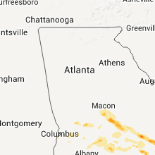


Cities Most Affected by Hail Storms of 6/5/2012
| Hail Size | Demographics of Zip Codes Affected | ||||||
|---|---|---|---|---|---|---|---|
| City | Count | Average | Largest | Pop Density | House Value | Income | Age |
| Glennville, GA | 2 | 2.25 | 2.75 | 42 | $73k | $31.2k | 35.0 |
| White Sulphur Springs, MT | 2 | 1.88 | 2.00 | 0 | $75k | $30.4k | 49.1 |
| Denton, MT | 1 | 1.75 | 1.75 | 0 | $38k | $29.5k | 49.0 |
| Mount Vernon, GA | 1 | 1.75 | 1.75 | 25 | $65k | $28.8k | 31.5 |
| Ailey, GA | 1 | 1.75 | 1.75 | 19 | $71k | $31.4k | 38.0 |
| Jeffersonville, GA | 1 | 1.75 | 1.75 | 12 | $63k | $30.2k | 46.2 |
| Lyons, GA | 1 | 1.75 | 1.75 | 41 | $51k | $25.0k | 35.0 |
| Riceboro, GA | 1 | 1.75 | 1.75 | 11 | $60k | $26.3k | 43.6 |
| Jefferson, GA | 1 | 1.75 | 1.75 | 204 | $103k | $41.3k | 36.0 |
| Vidalia, GA | 1 | 1.75 | 1.75 | 120 | $73k | $28.9k | 37.2 |
Hail and Wind Damage Spotted on 6/5/2012
Filter by Report Type:Hail ReportsWind Reports
Alabama
| Local Time | Report Details |
|---|---|
| 9:55 AM CDT | Numerous trees were reported down along the following roads...pruitt farm road...willow oak drive...hogan road and gibbons road. in addition vinyl siding was blown off in elmore county AL, 50.1 miles W of Auburn, AL |
| 5:20 PM CDT | Quarter sized hail reported near Loxley, AL, 18.6 miles ESE of Mobile, AL, quarter size hail reported in loxely by baldwin county ema. |
Georgia
| Local Time | Report Details |
|---|---|
| 12:30 PM EDT | Golf Ball sized hail reported near Jeffersonville, GA, 82.6 miles NNW of Douglas, GA, golf ball size hail occurred near hwy 358 and prospect church rd area not far from i-16. |
| 12:30 PM EDT | Golf Ball sized hail reported near Jefferson, GA, 51.8 miles ENE of Atlanta, GA, golf ball size hail occurred near hwy 358 and prospect church rd area not far from i-16. |
| 12:34 PM EDT | Golf Ball sized hail reported near Ailey, GA, 52.3 miles NNE of Douglas, GA |
| 12:35 PM EDT | Golf Ball sized hail reported near Mount Vernon, GA, 49.9 miles NNE of Douglas, GA |
| 12:40 PM EDT | Golf Ball sized hail reported near Vidalia, GA, 55.6 miles NNE of Douglas, GA |
| 12:40 PM EDT | Quarter sized hail reported near Perry, GA, 83.5 miles NW of Douglas, GA, near 1100 block of third street in perry |
| 12:57 PM EDT | Golf Ball sized hail reported near Lyons, GA, 52.6 miles NNE of Douglas, GA |
| 1:10 PM EDT | Quarter sized hail reported near Dexter, GA, 64.9 miles N of Douglas, GA |
| 1:20 PM EDT | Several trees dow in dodge county GA, 39.5 miles NNW of Douglas, GA |
| 1:28 PM EDT | Quarter sized hail reported near Manassas, GA, 56.9 miles W of Savannah, GA |
| 1:32 PM EDT | Quarter sized hail reported near Glennville, GA, 52.7 miles W of Savannah, GA |
| 1:40 PM EDT | Golf Ball sized hail reported near Glennville, GA, 51.9 miles W of Savannah, GA |
| 1:45 PM EDT | Baseball sized hail reported near Glennville, GA, 53.1 miles W of Savannah, GA, baseball size hail covering the ground. |
| 1:50 PM EDT | Quarter sized hail reported near Baxley, GA, 34.3 miles ENE of Douglas, GA, the ema reported nickle to quarter sized hail in baxley. there was also a report of a tree down. |
| 1:52 PM EDT | Several trees down in taylor county GA, 79.7 miles E of Auburn, AL |
| 2:00 PM EDT | Tree down in americus. wind gust to 38 mph also measured at sumter co airport awo in sumter county GA, 82.1 miles ESE of Auburn, AL |
| 2:08 PM EDT | Quarter sized hail reported near Hinesville, GA, 40.5 miles WSW of Savannah, GA |
| 2:11 PM EDT | Quarter sized hail reported near Ludowici, GA, 40.2 miles WSW of Savannah, GA, quarter size hail and wind gusts to 40 mph. |
| 2:31 PM EDT | Half Dollar sized hail reported near Riceboro, GA, 31 miles SW of Savannah, GA, hail between quarter and half dollar size falling along interstate 95 between mile markers 66 and 76. |
| 2:35 PM EDT | Golf Ball sized hail reported near Riceboro, GA, 30.8 miles SW of Savannah, GA |
| 3:05 PM EDT | 911 relayed a report a tree down in byron. time is estimated from radar in peach county GA, 84.1 miles SSE of Atlanta, GA |
| 3:13 PM EDT | The public reported a large 1 foot diameter branch down due to lightning near the intersection of highway 17 and chatham parkwa in chatham county GA, 5.1 miles WSW of Savannah, GA |
| 3:13 PM EDT | The public reported a large 1 foot diameter branch down near the intersection of highway 17 and chatham parkwa in chatham county GA, 5.1 miles WSW of Savannah, GA |
| 3:17 PM EDT | Quarter sized hail reported near , GA, 47.2 miles SSW of Savannah, GA, penny to quarter size hail at the sapelo island ferry dock. |
| 3:34 PM EDT | Quarter sized hail reported near Brunswick, GA, 59.3 miles N of Jacksonville, FL, quarter size hail reported on parkwood drive in brunswick. |
| 4:12 PM EDT | Multiple trees and powerlines down around thomas county. lightning struck a gas station generating a fir in thomas county GA, 39.7 miles NE of Tallahassee, FL |
| 4:55 PM EDT | Airport weather sensor reported 64 mph wind gust in thomas county GA, 39.7 miles NE of Tallahassee, FL |
| 4:55 PM EDT | Airport weather sensor reported 64 mph wind gust in thomas county GA, 39.7 miles NE of Tallahassee, FL |
| 4:55 PM EDT | Shingles blown off the foor of a home on centennial roa in thomas county GA, 41.3 miles NE of Tallahassee, FL |
| 5:05 PM EDT | Tree down across ozell road near vinson road intersection. power lines down in that area as wel in thomas county GA, 40.3 miles NE of Tallahassee, FL |
| 5:08 PM EDT | Multiple trees and powerlines down around thomas county. lightning struck a gas station generating a fir in thomas county GA, 42.5 miles NE of Tallahassee, FL |
| 5:12 PM EDT | Trees and powerlines down near pavo in brooks county GA, 55.4 miles NE of Tallahassee, FL |
| 5:36 PM EDT | Large pine tree down over roadway. estimated 50-60mph wind gus in thomas county GA, 44.9 miles NNE of Tallahassee, FL |
| 5:48 PM EDT | Trees and powerlines down in brooks county GA, 52.4 miles SW of Douglas, GA |
| 6:06 PM EDT | Trees down all over the hahira area in lowndes county GA, 47.7 miles SW of Douglas, GA |
| 6:30 PM EDT | Trees down all over colquitt county in colquitt county GA, 55.1 miles WSW of Douglas, GA |
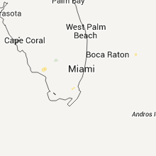
Florida
| Local Time | Report Details |
|---|---|
| 2:41 PM EDT | Usaf tower 511 at 35 in brevard county FL, 42.6 miles E of Orlando, FL |
| 2:58 PM CDT | Storm damage reported in jackson county FL, 61.5 miles WNW of Tallahassee, FL |
| 2:58 PM CDT | Storm damage reported in jackson county FL, 59.9 miles WNW of Tallahassee, FL |
| 4:03 PM EDT | Tree down capital circle ne in front of capital lanes in leon county FL, 3.1 miles ENE of Tallahassee, FL |
| 4:03 PM EDT | Tree down capital circle ne in front of capital lanes in leon county FL, 3.1 miles ENE of Tallahassee, FL |
| 3:10 PM CDT | Trees down northeast of marianna near the georgia state lin in jackson county FL, 53.1 miles WNW of Tallahassee, FL |
| 4:10 PM EDT | Large tree snapped across road in apartment complex in leon county FL, 3.7 miles NE of Tallahassee, FL |
| 4:12 PM EDT | Tree down on powerline by bucklake road and pedric in leon county FL, 6.2 miles ENE of Tallahassee, FL |
| 4:12 PM EDT | Two trees down in backyard avondale subdivisio in leon county FL, 6.2 miles ENE of Tallahassee, FL |
| 4:12 PM EDT | Trees down around the dempsy mayo road are in leon county FL, 4.7 miles ENE of Tallahassee, FL |
| 4:12 PM EDT | Trees down around the fleishmann road and miccosukee road are in leon county FL, 4.6 miles NE of Tallahassee, FL |
| 4:35 PM EDT | Trees down on roadway near intersection of miccosukee road and crump roa in leon county FL, 10.5 miles ENE of Tallahassee, FL |
| 4:35 PM EDT | Trees down on roadway in leon county FL, 10.5 miles ENE of Tallahassee, FL |
| 3:35 PM CDT | Several powerlines down on state road 18 in okaloosa county FL, 39.6 miles NNW of Miramar Beach, FL |
| 4:35 PM EDT | A railroad crossing arm was snapped along state road 710 6 miles west northwest of riviera beach as a thunderstorm moved through the regio in palm beach county FL, 33.7 miles SSE of Port Saint Lucie, FL |
| 4:35 PM EDT | A railroad sign was snapped along state road 710 6 miles west northwest of riviera beach as a thunderstorm moved through the regio in palm beach county FL, 33.7 miles SSE of Port Saint Lucie, FL |
| 4:36 PM EDT | Several trees were broken near old chemonie road and starhawk drive including a healthy 30 foot pine snapped in half and the crown of a hickory broken of in leon county FL, 13.1 miles NE of Tallahassee, FL |
| 4:36 PM EDT | Tree on the roadway on moccasin gap road just east of bradleys country stor in leon county FL, 15.8 miles NE of Tallahassee, FL |
| 4:12 PM CDT | Trees and powerlines down near pavo in holmes county FL, 62 miles NE of Miramar Beach, FL |
| 5:17 AM EDT | A mesonet site located in the southern portion of lake okeechobee reported a wind gust of 56 kts...or 64 mph...at 517 am ed in amz610 county FL, 40.1 miles SW of Port Saint Lucie, FL |
| 5:30 AM EDT | A mesonet site located near the center of lake okeechobee reported a wind gust of 54 kts...or 62 mph...at 530 am ed in amz610 county FL, 36.8 miles SW of Port Saint Lucie, FL |
Oklahoma
| Local Time | Report Details |
|---|---|
| 3:00 PM CDT | Storm damage reported in comanche county OK, 56.7 miles N of Wichita Falls, TX |
Montana
| Local Time | Report Details |
|---|---|
| 3:44 PM MDT | Golf Ball sized hail reported near White Sulphur Springs, MT, 60.5 miles N of Bozeman, MT, sheriff office reports golf ball size hail in white sulphur springs falling at the sheriff office. |
| 3:50 PM MDT | Quarter sized hail reported near White Sulphur Springs, MT, 60.5 miles N of Bozeman, MT |
| 4:17 PM MDT | Hen Egg sized hail reported near White Sulphur Springs, MT, 59.8 miles N of Bozeman, MT, hail measued at 2.0 inches |
| 5:00 PM MDT | Half Dollar sized hail reported near Wolf Creek, MT, 48.7 miles SW of Great Falls, MT, hail up to walnut size in the holter lake area. |
| 5:30 PM MDT | Golf Ball sized hail reported near Hobson, MT, 70.4 miles SE of Great Falls, MT, golf ball size hail reported by trained spotter |
| 5:41 PM MDT | Large garage flattened in judith basin county MT, 74.3 miles ESE of Great Falls, MT |
| 5:48 PM MDT | 90 mph wind gust in hobson in judith basin county MT, 76.1 miles ESE of Great Falls, MT |
| 5:50 PM MDT | Quarter sized hail reported near Stanford, MT, 65 miles ESE of Great Falls, MT, estimated 1.0 inch hail with rotation in se corner of wall cloud |
| 6:00 PM MDT | Quarter sized hail reported near Stanford, MT, 61.9 miles ESE of Great Falls, MT |
| 6:18 PM MDT | Golf Ball sized hail reported near Denton, MT, 64.9 miles E of Great Falls, MT, estimated golf ball size hail with funnel cloud observed |
| 6:55 PM MDT | Quarter sized hail reported near Geraldine, MT, 65.1 miles E of Great Falls, MT, estimated 1.0 inch plus size hail |
| 7:58 PM MDT | Half Dollar sized hail reported near Big Sandy, MT, 38.4 miles SW of Havre, MT |
Texas
| Local Time | Report Details |
|---|---|
| 4:45 PM CDT | Quarter sized hail reported near Brady, TX, 93.4 miles SSE of Abilene, TX, quarter size hail |
| 4:50 PM CDT | Half Dollar sized hail reported near Brady, TX, 93.4 miles SSE of Abilene, TX, three trees down. fire from lightning. |
| 4:15 AM CDT | Storm damage reported in garza county TX, 40.9 miles SSE of Lubbock, TX |
Wyoming
| Local Time | Report Details |
|---|---|
| 9:16 PM MDT | Storm damage reported in campbell county WY, 6.7 miles E of Gillette, WY |
| 10:10 PM MDT | Storm damage reported in campbell county WY, 50.1 miles NNE of Gillette, WY |
Louisiana
| Local Time | Report Details |
|---|---|
| 1:00 AM CDT | Trees down on binning road east of mansfiel in de soto county LA, 33.7 miles S of Shreveport, LA |
Connect with Interactive Hail Maps