

Hail Map for Monday, June 4, 2012

Number of Impacted Households on 6/4/2012
0
Impacted by 1" or Larger Hail
0
Impacted by 1.75" or Larger Hail
0
Impacted by 2.5" or Larger Hail
Square Miles of Populated Area Impacted on 6/4/2012
0
Impacted by 1" or Larger Hail
0
Impacted by 1.75" or Larger Hail
0
Impacted by 2.5" or Larger Hail


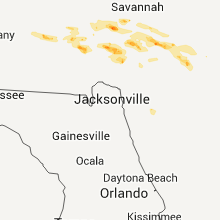


Cities Most Affected by Hail Storms of 6/4/2012
| Hail Size | Demographics of Zip Codes Affected | ||||||
|---|---|---|---|---|---|---|---|
| City | Count | Average | Largest | Pop Density | House Value | Income | Age |
| Fort Stewart, GA | 2 | 2.25 | 2.75 | 926 | $138k | $30.7k | 20.1 |
| Hinesville, GA | 2 | 1.75 | 1.75 | 619 | $78k | $34.4k | 28.5 |
| Floweree, MT | 1 | 2.75 | 2.75 | 1 | $119k | $42.4k | 48.3 |
| Carter, MT | 1 | 2.00 | 2.00 | 0 | $70k | $20.6k | 41.8 |
| Benton, MO | 1 | 1.75 | 1.75 | 40 | $81k | $34.7k | 38.8 |
| Mershon, GA | 1 | 1.75 | 1.75 | 14 | $72k | $28.8k | 37.0 |
| Midway, GA | 1 | 1.75 | 1.75 | 79 | $99k | $34.0k | 40.6 |
| Ballwin, MO | 1 | 1.75 | 1.75 | 2599 | $148k | $66.6k | 39.3 |
| Weippe, ID | 1 | 1.75 | 1.75 | 5 | $65k | $28.9k | 50.5 |
| Power, MT | 1 | 1.75 | 1.75 | 2 | $73k | $36.6k | 45.3 |
| Greenville, MS | 1 | 1.75 | 1.75 | 313 | $61k | $26.5k | 35.2 |
| Chesterfield, MO | 1 | 1.75 | 1.75 | 542 | $370k | $126.5k | 42.7 |
| Fort Benton, MT | 1 | 1.75 | 1.75 | 0 | $74k | $30.3k | 51.0 |
| Conrad, MT | 1 | 1.75 | 1.75 | 6 | $72k | $31.6k | 45.6 |
| Floydada, TX | 1 | 1.75 | 1.75 | 7 | $35k | $25.8k | 38.1 |
| Donnelly, ID | 1 | 1.75 | 1.75 | 5 | $153k | $33.5k | 40.2 |
| Hamilton, MT | 1 | 1.75 | 1.75 | 27 | $128k | $28.1k | 47.9 |
Hail and Wind Damage Spotted on 6/4/2012
Filter by Report Type:Hail ReportsWind Reports
States Impacted
Alabama, Oklahoma, Georgia, Arkansas, Oregon, Texas, Missouri, Montana, Colorado, Washington, California, Idaho, Mississippi, Illinois, TennesseeAlabama
| Local Time | Report Details |
|---|---|
| 7:18 AM CDT | Tree down on power line in carrollto in pickens county AL, 43.6 miles ESE of Starkville, MS |
Oklahoma
| Local Time | Report Details |
|---|---|
| 7:35 AM CDT | Storm damage reported in comanche county OK, 56.7 miles N of Wichita Falls, TX |
Georgia
| Local Time | Report Details |
|---|---|
| 1:05 PM EDT | Quarter sized hail reported near Glennville, GA, 49.6 miles W of Savannah, GA, the public reported quarter size hail. |
| 1:13 PM EDT | Tree down at intersection of altamaha st. and sherman s in ben hill county GA, 27.8 miles WNW of Douglas, GA |
| 1:15 PM EDT | Numerous trees down in baxley. time estimated by rada in appling county GA, 36.1 miles NE of Douglas, GA |
| 1:23 PM EDT | Tree down near mile marker in ben hill county GA, 19.9 miles NW of Douglas, GA |
| 1:32 PM EDT | Several spotters reported numerous large trees down on fort stewar in liberty county GA, 33.2 miles WSW of Savannah, GA |
| 1:32 PM EDT | Quarter sized hail reported near Fort Stewart, GA, 33.2 miles WSW of Savannah, GA, spotter reported quarter size hail near gate 3 of fort stewart. |
| 1:32 PM EDT | Ping Pong Ball sized hail reported near Hinesville, GA, 33.9 miles WSW of Savannah, GA, golfball size hail fell at the liberty county warning point. |
| 1:32 PM EDT | Baseball sized hail reported near Fort Stewart, GA, 34 miles WSW of Savannah, GA, the fort stewart warning point reported golf ball to baseball size hail. 1 vehicle had major damage. |
| 1:35 PM EDT | Golf Ball sized hail reported near Fort Stewart, GA, 33.2 miles WSW of Savannah, GA, several reports of quarter and golf ball size hail at fort stewart. |
| 1:37 PM EDT | Golf Ball sized hail reported near Hinesville, GA, 33.9 miles WSW of Savannah, GA, numerous reports of golf ball size hail near the hospital in hinesville. |
| 1:40 PM EDT | Golf Ball sized hail reported near Hinesville, GA, 33.7 miles WSW of Savannah, GA, spotter reported golf ball size hail and numerous large limbs don on stewart drive. |
| 1:40 PM EDT | Spotter reported golf ball size hail and numerous large limbs don on stewart driv in liberty county GA, 33.7 miles WSW of Savannah, GA |
| 1:40 PM EDT | Several large branches down northwest of broxton on fitzgerald highway in coffee county GA, 12.8 miles NNW of Douglas, GA |
| 1:44 PM EDT | Quarter sized hail reported near Midway, GA, 27.9 miles SW of Savannah, GA, a trained weather spotter reported quarter size hail along main trail road. |
| 1:45 PM EDT | Golf Ball sized hail reported near Midway, GA, 30.6 miles SW of Savannah, GA, the public reported golf ball size hail. |
| 1:45 PM EDT | The public reported a large oak tree uprooted in a front yar in liberty county GA, 30.6 miles SW of Savannah, GA |
| 1:53 PM EDT | Law enforcement reported trees down along highway 144 near richmond hill georgi in bryan county GA, 16.8 miles WSW of Savannah, GA |
| 2:12 PM EDT | A emergency manager reported one tree down along highway 301 near jones creek georgi in long county GA, 47.9 miles WSW of Savannah, GA |
| 2:18 PM EDT | Officials with the harris neck national wildlife refuge reported trees blown down in several locations on the refuge. the damage assessment is ongoing. time estimated b in mcintosh county GA, 32.1 miles SSW of Savannah, GA |
| 2:20 PM EDT | A emergency manager reported one tree down near the intersection of highway 84 and doyle durrence lan in long county GA, 43.7 miles WSW of Savannah, GA |
| 2:21 PM EDT | A emergency manager reported a tree down along presley roa in long county GA, 45.2 miles WSW of Savannah, GA |
| 2:30 PM EDT | Tree reported down on old waynesville roa in wayne county GA, 57.4 miles SW of Savannah, GA |
| 2:30 PM EDT | Numerous trees and powerlines down in the mershon are in pierce county GA, 35 miles E of Douglas, GA |
| 2:30 PM EDT | Golf Ball sized hail reported near Mershon, GA, 34.9 miles E of Douglas, GA, law enforcement reported golf ball size hail in the mershon area. |
| 2:33 PM EDT | Numerous trees and powerlines down in the bristol are in pierce county GA, 38 miles E of Douglas, GA |
| 2:42 PM EDT | Numerous trees and powerlines down in the patterson are in pierce county GA, 42.8 miles ESE of Douglas, GA |
| 2:57 PM EDT | Trees and powerlines were reported blown down near highway 251 and townsend cox road. time estimated based on rada in mcintosh county GA, 45.5 miles SSW of Savannah, GA |
| 2:59 PM EDT | A emergency manager reported 2 trees down along highway 9 in mcintosh county GA, 52.9 miles SSW of Savannah, GA |
| 3:00 PM EDT | A emergency manager reported a tree down in carnigan georgi in mcintosh county GA, 48.2 miles SSW of Savannah, GA |
| 3:01 PM EDT | Trees and powerlines were reported blown down along highway 17 just north of darien. time estimated based on rada in mcintosh county GA, 51.6 miles SSW of Savannah, GA |
| 3:25 PM EDT | Tree reported down on tupelo circle near highway 1 in glynn county GA, 59.5 miles SSW of Savannah, GA |
| 3:29 PM EDT | Tree reported down on village driv in glynn county GA, 61.4 miles SSW of Savannah, GA |
| 3:31 PM EDT | Tree reported down at peachtree street and beach driv in glynn county GA, 57.9 miles NNE of Jacksonville, FL |
Arkansas
| Local Time | Report Details |
|---|---|
| 1:25 PM CDT | Thunderstorm winds broke off the tops of several oak trees at the perry/pulaski county lin in pulaski county AR, 28 miles WNW of Little Rock, AR |
| 3:42 PM CDT | Quarter sized hail reported near Leola, AR, 41.3 miles SSW of Little Rock, AR, member of public called and reported hail approximately the size of quarters. |
| 3:44 PM CDT | Quarter sized hail reported near Poyen, AR, 36.2 miles SW of Little Rock, AR |
| 4:26 PM CDT | Trees are down along county road 16 north of grapevin in grant county AR, 40.7 miles S of Little Rock, AR |
| 5:08 PM CDT | Many power lines are down across rison leaving many people without powe in cleveland county AR, 55.3 miles S of Little Rock, AR |
| 5:29 PM CDT | Quarter sized hail reported near Fordyce, AR, 59.6 miles S of Little Rock, AR |
| 7:00 PM CDT | A few trees and power lines down in chicot county AR, 58.7 miles NNE of Bastrop, LA |
Oregon
| Local Time | Report Details |
|---|---|
| 1:35 PM PDT | Quarter sized hail reported near Grants Pass, OR, 24.1 miles WNW of Medford, OR, south grants pass. tstm with winds 20 to 25 mph. hail a liitle bigger than quarter size. |
| 1:55 PM PDT | Also reporting heavy rain and one quarter inch hail lasting approx 10 min in douglas county OR, 49.4 miles NNW of Medford, OR |
Texas
| Local Time | Report Details |
|---|---|
| 4:05 PM CDT | Storm damage reported in hale county TX, 32.2 miles N of Lubbock, TX |
| 6:05 PM CDT | Four utility poles snapped along us 62 82 in hockley county TX, 17.2 miles SW of Lubbock, TX |
| 6:20 PM CDT | Measured by the texas tech university west texas mesonet in lubbock county TX, 15.8 miles SW of Lubbock, TX |
| 6:28 PM CDT | Golf Ball sized hail reported near Floydada, TX, 36.7 miles NE of Lubbock, TX |
| 6:58 PM CDT | Quarter sized hail reported near Adrian, TX, 47 miles W of Amarillo, TX, quarter size hail reported near adrian |
| 7:00 PM CDT | Strong winds blew a 6 inch tree limb down in adria in oldham county TX, 47 miles W of Amarillo, TX |
| 7:08 PM CDT | Quarter sized hail reported near Adrian, TX, 47 miles W of Amarillo, TX |
| 7:11 PM CDT | Quarter sized hail reported near Stinnett, TX, 51.6 miles NNE of Amarillo, TX |
| 7:21 PM CDT | Public reported part of roof on a house was removed by strong winds. this report was relayed by the sheriffs offic in oldham county TX, 47 miles W of Amarillo, TX |
| 7:23 PM CDT | A storage building was destroyed and windows were broken in a residential structur in oldham county TX, 46.8 miles W of Amarillo, TX |
| 7:23 PM CDT | Telephone pole was blown dow in oldham county TX, 46.8 miles W of Amarillo, TX |
| 7:23 PM CDT | Half Dollar sized hail reported near Adrian, TX, 46.8 miles W of Amarillo, TX |
| 7:30 PM CDT | Quarter sized hail reported near Adrian, TX, 47 miles W of Amarillo, TX, quarter size hail and wind gusts up to 50 mph. |
| 8:15 PM CDT | Delayed report...a lot of downed tree limbs at pitchfork ranch. time estimate in dickens county TX, 60 miles SSW of Childress, TX |
| 9:20 PM CDT | Measured by the texas tech university west texas mesonet in garza county TX, 58.4 miles SE of Lubbock, TX |
| 9:55 PM CDT | Measured by the texas tech university west texas mesonet in scurry county TX, 67.7 miles WNW of Abilene, TX |
Missouri
| Local Time | Report Details |
|---|---|
| 4:09 PM CDT | Quarter sized hail reported near St Peters, MO, 27.1 miles WNW of Saint Louis, MO, spotter located near highways 70 and 79. hail covering the ground |
| 4:10 PM CDT | Quarter sized hail reported near St Peters, MO, 24.5 miles WNW of Saint Louis, MO |
| 4:12 PM CDT | Power lines downed in st. charles county MO, 20.6 miles WNW of Saint Louis, MO |
| 4:15 PM CDT | Quarter sized hail reported near St Charles, MO, 25.8 miles WNW of Saint Louis, MO |
| 4:16 PM CDT | Quarter sized hail reported near St Peters, MO, 24.5 miles WNW of Saint Louis, MO, at saint charles community college |
| 4:21 PM CDT | Ping Pong Ball sized hail reported near St Charles, MO, 25.8 miles WNW of Saint Louis, MO |
| 4:21 PM CDT | Ping Pong Ball sized hail reported near St Charles, MO, 25.2 miles WNW of Saint Louis, MO, intersection of highway 94 and ofallon road. |
| 4:23 PM CDT | Quarter sized hail reported near St Peters, MO, 24.5 miles WNW of Saint Louis, MO |
| 4:24 PM CDT | Ping Pong Ball sized hail reported near St Charles, MO, 24.8 miles WNW of Saint Louis, MO |
| 4:24 PM CDT | Six inch diameter tree down with power outages near intersection of clarkson and clayto in st. louis county MO, 20.6 miles W of Saint Louis, MO |
| 4:29 PM CDT | Golf Ball sized hail reported near Chesterfield, MO, 20.6 miles W of Saint Louis, MO, mostly quarters but some up to golf balls near intersection of highway 40 and boones crossing. |
| 4:40 PM CDT | Quarter sized hail reported near Chesterfield, MO, 20.6 miles W of Saint Louis, MO |
| 4:41 PM CDT | Ping Pong Ball sized hail reported near Chesterfield, MO, 20.6 miles W of Saint Louis, MO, relayed from fox-2 from one of their meteorologists on location |
| 4:43 PM CDT | Golf Ball sized hail reported near Ballwin, MO, 19.1 miles W of Saint Louis, MO, intersection of big bend and new ballwin. |
| 4:45 PM CDT | Quarter sized hail reported near Ballwin, MO, 21.3 miles W of Saint Louis, MO |
| 4:48 PM CDT | Ping Pong Ball sized hail reported near Ballwin, MO, 19.1 miles W of Saint Louis, MO |
| 4:50 PM CDT | Quarter sized hail reported near Ballwin, MO, 17 miles W of Saint Louis, MO |
| 4:56 PM CDT | Quarter sized hail reported near High Ridge, MO, 20.3 miles WSW of Saint Louis, MO |
| 4:59 PM CDT | Half Dollar sized hail reported near High Ridge, MO, 19 miles WSW of Saint Louis, MO, at intersection of bridleridge crossing spur and hillsboro road. |
| 5:04 PM CDT | Ping Pong Ball sized hail reported near High Ridge, MO, 21.3 miles WSW of Saint Louis, MO, near intersection of w ridge road and rock creek road. |
| 5:10 PM CDT | Half Dollar sized hail reported near House Springs, MO, 22.9 miles SW of Saint Louis, MO |
| 5:10 PM CDT | Half Dollar sized hail reported near Imperial, MO, 20.5 miles SW of Saint Louis, MO |
| 8:30 PM CDT | Golf Ball sized hail reported near Benton, MO, 14 miles S of Cape Girardeau, MO, late report.. golf ball hail reported by media. |
| 8:40 PM CDT | Downburst from 2.5 miles north of diehlstadt to 1 mile south of diehlstadt. peak wind 100 mph. path length 3.5 miles. path width 1/2 mile. 52 homes damaged with mostly in scott county MO, 22.5 miles SSE of Cape Girardeau, MO |
| 8:45 PM CDT | *** 3 fatal *** updated and corrected...time adjusted based on doppler radar data. missouri state policeconfirmed 3 fatalities with no information concerning injurie in scott county MO, 24.5 miles SSE of Cape Girardeau, MO |
| 8:45 PM CDT | *** 3 fatal *** updated and corrected...time adjusted based on doppler radar data. missouri state police confirmed 3 fatalities with no information concerning injurie in scott county MO, 24.5 miles SSE of Cape Girardeau, MO |
| 9:09 PM CDT | Late report. mobile home reported overturned and fire/rescue is repsonding. report received by state polic in scott county MO, 24.5 miles SSE of Cape Girardeau, MO |
Montana
| Local Time | Report Details |
|---|---|
| 3:15 PM MDT | Golf Ball sized hail reported near Hamilton, MT, 43.7 miles S of Missoula, MT, photo with ruler. |
| 3:30 PM MDT | Quarter sized hail reported near Anaconda, MT, 58.8 miles SE of Missoula, MT |
| 3:33 PM MDT | Quarter sized hail reported near Stevensville, MT, 33.4 miles S of Missoula, MT |
| 3:40 PM MDT | Quarter sized hail reported near Darby, MT, 49.7 miles NNW of Salmon, ID, very heavy rain also. |
| 4:07 PM MDT | Quarter sized hail reported near Philipsburg, MT, 58.8 miles SE of Missoula, MT, heavy rain also. |
| 4:40 PM MDT | Quarter sized hail reported near Bonner, MT, 30.9 miles ENE of Missoula, MT |
| 5:20 PM MDT | Quarter sized hail reported near Lincoln, MT, 62.4 miles E of Missoula, MT, quater size hail near stemple pass |
| 6:45 PM MDT | Estimated 50 kts....58 mph 10 w great falls....retired nws employee in cascade county MT, 9.6 miles W of Great Falls, MT |
| 6:45 PM MDT | Estimated 70 mph wind gust at ulm pishkun in cascade county MT, 9.6 miles W of Great Falls, MT |
| 6:48 PM MDT | Quarter sized hail reported near Vaughn, MT, 11.8 miles WNW of Great Falls, MT, estimated 1 inch hail just south of vaughn. |
| 6:49 PM MDT | Marble size hail...wind estimated to 60 mph...gustnado in cascade county MT, 12 miles WNW of Great Falls, MT |
| 7:01 PM MDT | Golf Ball sized hail reported near Power, MT, 17.7 miles NW of Great Falls, MT, golf ball size hail a few miles southeast of power. |
| 7:08 PM MDT | Quarter sized hail reported near Power, MT, 23.2 miles NW of Great Falls, MT, estimated 1 inch hail near power |
| 7:15 PM MDT | Damage to small buildings and fences at local race track...loose equipment displaced 200 feet in cascade county MT, 2 miles NE of Great Falls, MT |
| 7:17 PM MDT | Quarter sized hail reported near Great Falls, MT, 8.5 miles WNW of Great Falls, MT, estimated 1 inch hail in sun prairie |
| 7:28 PM MDT | Tennis Ball sized hail reported near Carter, MT, 29.9 miles NE of Great Falls, MT, estimated 2.5 inch hail....70 mph wind...and debris along hwy 87. vehicle windowshields blown out |
| 7:28 PM MDT | Estimated 2.5 inch hail....70 mph wind...and debris along hwy 87. vehicle windowshields blown out in chouteau county MT, 29.9 miles NE of Great Falls, MT |
| 7:35 PM MDT | Baseball sized hail reported near Floweree, MT, 18.9 miles NE of Great Falls, MT, damage to police vehicles |
| 7:35 PM MDT | Hen Egg sized hail reported near Carter, MT, 24.3 miles NE of Great Falls, MT |
| 7:35 PM MDT | Storm damage reported in chouteau county MT, 24.3 miles NE of Great Falls, MT |
| 7:40 PM MDT | Golf Ball sized hail reported near Fort Benton, MT, 33.9 miles NE of Great Falls, MT, window damage on houses |
| 8:14 PM MDT | 87 mph wind gust at the dot sensor just north of lom in chouteau county MT, 48.5 miles NE of Great Falls, MT |
| 8:17 PM MDT | Estimated winds 75 mph...storm shows rotation in chouteau county MT, 50.8 miles NE of Great Falls, MT |
| 8:24 PM MDT | Roof blown off garage and 3 to 4 inch diameter tree branches down in chouteau county MT, 48 miles NE of Great Falls, MT |
| 8:30 PM MDT | Pieces of siding from a grain bin reported on hwy 87 in chouteau county MT, 42.2 miles SW of Havre, MT |
| 9:18 PM MDT | Golf Ball sized hail reported near Conrad, MT, 43.2 miles NNW of Great Falls, MT |
| 10:23 PM MDT | Golf Ball sized hail reported near Conrad, MT, 60 miles NW of Great Falls, MT, golfball sized hail |
Colorado
| Local Time | Report Details |
|---|---|
| 4:23 PM MDT | Storm damage reported in mesa county CO, 26.2 miles NE of Grand Junction, CO |
Washington
| Local Time | Report Details |
|---|---|
| 3:43 PM PDT | Quarter sized hail reported near Clarkston, WA, 49.1 miles ENE of Walla Walla, WA |
California
| Local Time | Report Details |
|---|---|
| 5:10 PM PDT | Quarter sized hail reported near Cottonwood, CA, 17.8 miles S of Redding, CA, spotter reported hail falling between dime and quarter size. hail also covering the ground. |
| 5:45 PM PDT | Quarter sized hail reported near Cottonwood, CA, 20.4 miles SSE of Redding, CA, hail between dime and quarter size. hail covering the ground. |
| 6:00 PM PDT | Half Dollar sized hail reported near Cottonwood, CA, 16.8 miles SSE of Redding, CA |
| 6:28 PM PDT | Quarter sized hail reported near Cottonwood, CA, 19.3 miles S of Redding, CA, hail sizes of 5/8 inch to 1 inch in size. 2 inches of hail depth accumulated on ground so far. small branches down. |
Idaho
| Local Time | Report Details |
|---|---|
| 5:10 PM PDT | Ping Pong Ball sized hail reported near Plummer, ID, 41.1 miles SE of Spokane, WA |
| 6:13 PM MDT | Quarter sized hail reported near Cambridge, ID, 70.8 miles NNW of Boise, ID, public report via local media. time estimated based on radar. |
| 6:15 PM PDT | Quarter sized hail reported near Grangeville, ID, 4.6 miles SE of Grangeville, ID |
| 6:41 PM PDT | Us navy buoy on lake pend oreille measured wind gust in bonner county ID, 52.2 miles NE of Spokane, WA |
| 6:55 PM PDT | Golf Ball sized hail reported near Weippe, ID, 30.2 miles NNE of Grangeville, ID |
| 7:55 PM MDT | 60 inch tree snapped. time estimate in valley county ID, 62.8 miles N of Boise, ID |
| 8:00 PM MDT | Golf Ball sized hail reported near Donnelly, ID, 77.7 miles N of Boise, ID, a public report relayed via local media. |
| 8:02 PM MDT | Quarter sized hail reported near Council, ID, 78.4 miles N of Boise, ID, public report via local media.time estimated from radar |
| 7:15 PM PDT | Half Dollar sized hail reported near Riggins, ID, 36.1 miles SSW of Grangeville, ID |
| 8:16 PM MDT | Pilot reported microburst with winds blowing upright pine trees off 30 degree in valley county ID, 62.8 miles N of Boise, ID |
| 8:20 PM MDT | Numerous trees down between cascade and mccall.time of event between 750 pm mdt 830 md in valley county ID, 70.1 miles S of Grangeville, ID |
| 8:39 PM MDT | Tea pot raw in valley county ID, 73.2 miles SSE of Grangeville, ID |
| 8:40 PM MDT | Forest service dispatch reporting 3/4 of a mile of ponderosa pine trees snapped off half way up the trunk. approx 30 ponderosa pine trees 120 feet tall down at the work in valley county ID, 68.6 miles SSE of Grangeville, ID |
| 7:50 PM PDT | Quarter sized hail reported near Kamiah, ID, 26.8 miles N of Grangeville, ID |
| 8:52 PM MDT | Forest service dispatch reporting 3/4 of a mile of ponderosa pine trees snapped off half way up the trunk. approx 30 ponderosa pine trees 120 feet tall down at the work in valley county ID, 68.6 miles SSE of Grangeville, ID |
| 7:55 PM PDT | Golf Ball sized hail reported near Weippe, ID, 32.4 miles NNE of Grangeville, ID |
| 8:55 PM PDT | Three rivers resort. high winds with multiple trees down. lost interne in idaho county ID, 29 miles ENE of Grangeville, ID |
Mississippi
| Local Time | Report Details |
|---|---|
| 7:35 PM CDT | Some lines down in bolivar county MS, 74.3 miles NE of Bastrop, LA |
| 7:42 PM CDT | Quarter sized hail reported near Greenville, MS, 70.2 miles NE of Bastrop, LA |
| 8:05 PM CDT | A large tree was uprooted on washington ave. power lines were downed at two locations in the cit in washington county MS, 65.5 miles NE of Bastrop, LA |
| 8:05 PM CDT | Entire roof was removed from one unit at an apartment complex resulting in two families being displace in washington county MS, 65.5 miles NE of Bastrop, LA |
| 8:05 PM CDT | Peeled back shingles off apartment complex and lots of tree limbs down reported by wxvt meteorologis in washington county MS, 65.5 miles NE of Bastrop, LA |
| 8:05 PM CDT | A large tree fell across s main st at the greenville cemetary...blocking multiple lanes of traffic in washington county MS, 65.5 miles NE of Bastrop, LA |
| 8:25 PM CDT | Power outages due to trees falling on wire in sunflower county MS, 83.7 miles NNW of Jackson, MS |
| 8:26 PM CDT | Golf Ball sized hail reported near Greenville, MS, 67.5 miles ENE of Bastrop, LA |
| 8:35 PM CDT | Several trees and power lines down in washington county MS, 69 miles ENE of Bastrop, LA |
| 9:55 PM CDT | Several large tree limbs blocking roads in belzon in humphreys county MS, 63.3 miles NNW of Jackson, MS |
Illinois
| Local Time | Report Details |
|---|---|
| 8:50 PM CDT | Quarter sized hail reported near Metropolis, IL, 44.2 miles E of Cape Girardeau, MO |
Tennessee
| Local Time | Report Details |
|---|---|
| 10:34 PM CDT | Public report of trees down near white plains golf course on plantation circle. one tree down on power lines. power outage reported in algoo in putnam county TN, 75.4 miles E of Nashville, TN |
| 10:36 PM CDT | Tree down on cars near the bangham communit in putnam county TN, 72.1 miles E of Nashville, TN |
| 10:39 PM CDT | Numerous trees were blown down around algood. locations include plantation c in putnam county TN, 74.3 miles E of Nashville, TN |
| 1:12 AM CDT | A few trees were blown down across roadways in southern benton count in benton county TN, 26.3 miles ESE of Mc Kenzie, TN |
Connect with Interactive Hail Maps