

Hail Map for Tuesday, May 30, 2023

Number of Impacted Households on 5/30/2023
0
Impacted by 1" or Larger Hail
0
Impacted by 1.75" or Larger Hail
0
Impacted by 2.5" or Larger Hail
Square Miles of Populated Area Impacted on 5/30/2023
0
Impacted by 1" or Larger Hail
0
Impacted by 1.75" or Larger Hail
0
Impacted by 2.5" or Larger Hail


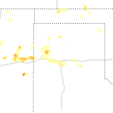


Cities Most Affected by Hail Storms of 5/30/2023
| Hail Size | Demographics of Zip Codes Affected | ||||||
|---|---|---|---|---|---|---|---|
| City | Count | Average | Largest | Pop Density | House Value | Income | Age |
| Blackduck, MN | 2 | 2.00 | 2.00 | 8 | $64k | $27.7k | 42.3 |
| Scenic, SD | 1 | 1.75 | 1.75 | 0 | $17k | $31.8k | 48.8 |
| Council Grove, KS | 1 | 1.75 | 1.75 | 12 | $55k | $31.9k | 48.5 |
| Amherst, CO | 1 | 1.75 | 1.75 | 2 | $78k | $36.5k | 36.4 |
Hail and Wind Damage Spotted on 5/30/2023
Filter by Report Type:Hail ReportsWind Reports
States Impacted
Wyoming, Minnesota, Kansas, South Dakota, Colorado, Nebraska, New Mexico, Oklahoma, TexasWyoming
| Local Time | Report Details |
|---|---|
| 1:58 PM MDT | Quarter sized hail reported near Beulah, WY, 52.7 miles NW of Rapid City, SD |
| 5:53 PM MDT | Asos station kdgw douglas airport - dg in converse county WY, 48.3 miles E of Casper, WY |
Minnesota
| Local Time | Report Details |
|---|---|
| 3:30 PM CDT | Quarter sized hail reported near Fertile, MN, 49.8 miles NNE of Fargo, ND, report relayed via twitter with a picture showing a handful of quarter sized hail and the approximate time. |
| 4:15 PM CDT | Quarter sized hail reported near Wendell, MN, 68.1 miles SSE of Fargo, ND, grant county reports quarter size hail. |
| 4:45 PM CDT | Half Dollar sized hail reported near Blackduck, MN, 25.2 miles NE of Bemidji, MN, 1-1.25 inch hail. |
| 4:45 PM CDT | Hen Egg sized hail reported near Blackduck, MN, 25.2 miles NE of Bemidji, MN, corrects previous hail report from 2 ne blackduck. 1-1.25 inch hail. |
| 4:45 PM CDT | Half Dollar sized hail reported near Lengby, MN, 36.7 miles W of Bemidji, MN, largest stone was 1.25 with average around 1 inch. |
| 4:45 PM CDT | Hen Egg sized hail reported near Blackduck, MN, 30.3 miles NE of Bemidji, MN, half dollar to golf ball size hail reported via social media. |
| 5:10 PM CDT | Quarter sized hail reported near Bagley, MN, 30.6 miles W of Bemidji, MN, social media report of quarter size hail. |
| 5:10 PM CDT | Quarter sized hail reported near Fosston, MN, 42.3 miles W of Bemidji, MN, public report via facebook. |
| 5:30 PM CDT | Half Dollar sized hail reported near Perham, MN, 62.6 miles ESE of Fargo, ND |
| 5:57 PM CDT | Quarter sized hail reported near Deer River, MN, 47.2 miles E of Bemidji, MN, report from bowstring lake area of a large amount of hailstones ranging from pea size to quarter size. time estimated from radar. |
| 6:04 PM CDT | Quarter sized hail reported near Bagley, MN, 24 miles WSW of Bemidji, MN, report relayed via facebook. |
| 6:45 PM CDT | Pontoon boat and lift overturned on schoolcraft rive in beltrami county MN, 4.1 miles SSW of Bemidji, MN |
Kansas
| Local Time | Report Details |
|---|---|
| 3:43 PM CDT | Quarter sized hail reported near Peabody, KS, 35.5 miles NNE of Wichita, KS |
| 4:05 PM CDT | Storm damage reported in shawnee county KS, 32.9 miles E of Manhattan, KS |
| 4:06 PM CDT | Golf Ball sized hail reported near Council Grove, KS, 34.4 miles S of Manhattan, KS, delayed report. |
| 4:14 PM CDT | Half Dollar sized hail reported near Belvue, KS, 19.6 miles E of Manhattan, KS, social media report. |
| 4:25 PM CDT | Storm damage reported in wabaunsee county KS, 23.2 miles E of Manhattan, KS |
| 4:35 PM CDT | Storm damage reported in wabaunsee county KS, 34.4 miles ESE of Manhattan, KS |
| 4:43 PM CDT | Half inch diameter tree limbs dow in shawnee county KS, 38.1 miles E of Manhattan, KS |
| 4:45 PM CDT | Storm damage reported in shawnee county KS, 34 miles E of Manhattan, KS |
| 4:45 PM CDT | Delayed report. time estimated from radar. 3-4 inch tree limb snappe in shawnee county KS, 42.4 miles ESE of Manhattan, KS |
| 5:15 PM CDT | Quarter sized hail reported near Cedar Point, KS, 51.5 miles NE of Wichita, KS |
| 5:35 PM CDT | Half Dollar sized hail reported near Ogallah, KS, 28 miles WNW of Hays, KS |
| 5:40 PM CDT | Quarter sized hail reported near Burrton, KS, 29.4 miles NW of Wichita, KS, courtesy of kwch. time estimated by radar. |
| 5:55 PM CDT | Half Dollar sized hail reported near Rexford, KS, 17.1 miles ENE of Colby, KS, hail was dime to half dollar size hail. ground was 50 percent covered. |
| 6:07 PM CDT | Quarter sized hail reported near Quinter, KS, 48.7 miles ESE of Colby, KS, social media image of quarter size hail. |
| 6:40 PM CDT | Quarter sized hail reported near Park, KS, 43.5 miles ESE of Colby, KS |
| 8:15 PM CDT | Awos station ktqk scott cit in scott county KS, 34.5 miles N of Garden City, KS |
| 8:20 PM CDT | Mesonet station ew9720 scott cit in scott county KS, 40.4 miles N of Garden City, KS |
| 8:26 PM CDT | Reported 55 to 70 mph wind in scott county KS, 35.2 miles N of Garden City, KS |
| 8:26 PM CDT | Quarter sized hail reported near Scott City, KS, 35.2 miles N of Garden City, KS |
| 8:30 PM CDT | Mesonet station dw2812 scott cit in scott county KS, 35.4 miles NNE of Garden City, KS |
| 8:32 PM CDT | Spotter reported about 200 yds visibility in blowing dir in lane county KS, 37 miles NNE of Garden City, KS |
| 9:03 PM CDT | Asos station kgck garden cit in finney county KS, 9 miles ESE of Garden City, KS |
| 9:08 PM CDT | From kak in finney county KS, 1 miles NE of Garden City, KS |
| 9:15 PM CDT | Mesonet station ks010 us-50 @ k-156 bridge garden cit in finney county KS, 1.9 miles ENE of Garden City, KS |
| 9:31 PM CDT | On grain elevator from kak in finney county KS, 1 miles NE of Garden City, KS |
| 9:36 PM CDT | On grain elevator from kak in finney county KS, 1 miles NE of Garden City, KS |
| 10:15 PM CDT | Mesonet station sauk1 satant in seward county KS, 45.5 miles S of Garden City, KS |
| 10:22 PM CDT | Report from mping: 1-inch tree limbs broken; shingles blown of in norton county KS, 68.2 miles ENE of Colby, KS |
| 10:41 PM CDT | Mesonet station ur350 4.4 ne hayne (upr in seward county KS, 56.9 miles S of Garden City, KS |
South Dakota
| Local Time | Report Details |
|---|---|
| 2:58 PM MDT | Quarter sized hail reported near Rapid City, SD, 7.6 miles SSE of Rapid City, SD, mostly nickels. couple quarters. |
| 3:47 PM MDT | Quarter sized hail reported near Rapid City, SD, 8.3 miles SSE of Rapid City, SD, mostly dimes and nickels but a few quarters. |
| 3:48 PM MDT | Quarter sized hail reported near Rapid City, SD, 7.6 miles SSE of Rapid City, SD, mostly smaller. few one and one eight inch pieces. |
| 4:05 PM MDT | Quarter sized hail reported near Hermosa, SD, 10.7 miles SE of Rapid City, SD, mostly marble sized with a few quarters |
| 5:00 PM MDT | Quarter sized hail reported near Hermosa, SD, 15.4 miles S of Rapid City, SD, mostly dimes but a few quarters. |
| 5:42 PM MDT | Golf Ball sized hail reported near Scenic, SD, 37.7 miles ESE of Rapid City, SD, lots of quarters with a few golf ball size hail pieces. |
| 5:57 PM MDT | Quarter sized hail reported near Nemo, SD, 19 miles WNW of Rapid City, SD, mostly large pea size but a few quarters |
| 6:06 PM MDT | Storm damage reported in oglala lakota county SD, 80.9 miles SSE of Rapid City, SD |
| 7:10 PM MDT | Ping Pong Ball sized hail reported near Kyle, SD, 53.2 miles ESE of Rapid City, SD |
| 7:59 PM MDT | Storm damage reported in jackson county SD, 72.3 miles ESE of Rapid City, SD |
| 8:59 PM MDT | Storm damage reported in jackson county SD, 49.4 miles SW of Pierre, SD |
Colorado
| Local Time | Report Details |
|---|---|
| 4:38 PM MDT | Quarter sized hail reported near Colorado Springs, CO, 48.4 miles N of Pueblo, CO, soft hail. |
| 5:26 PM MDT | Quarter sized hail reported near Cheyenne Wells, CO, 77.4 miles WSW of Colby, KS, report from mping: quarter (1.00 in.). |
| 7:31 PM MDT | Quarter sized hail reported near Yuma, CO, 20.2 miles NE of Yuma, CO, report via facebook from wfo boulder. time estimated via radar. |
| 7:59 PM MDT | Quarter sized hail reported near Holyoke, CO, 44.6 miles NNE of Yuma, CO, soft hail... and just a few larger stones. |
| 8:15 PM MDT | Golf Ball sized hail reported near Amherst, CO, 46.1 miles NE of Yuma, CO |
| 8:17 PM MDT | Quarter sized hail reported near Amherst, CO, 45.8 miles NE of Yuma, CO |
| 8:22 PM MDT | Storm damage reported in sedgwick county CO, 63.8 miles NNE of Yuma, CO |
Nebraska
| Local Time | Report Details |
|---|---|
| 6:10 PM MDT | Awos station k1cw 9 e harrisbur in banner county NE, 20 miles SSE of Scottsbluff, NE |
| 6:38 PM MDT | Quarter sized hail reported near Gordon, NE, 86.8 miles W of Valentine, NE |
| 7:58 PM MDT | Report of 60 to 65 mph winds... also heavy rainfall observed but no amount give in sheridan county NE, 84.9 miles E of Scottsbluff, NE |
| 8:00 PM MDT | Public reports 70 mph wind gus in grant county NE, 78.9 miles NW of North Platte, NE |
| 10:44 PM CDT | Report via at home weather senso in lincoln county NE, 19.8 miles W of North Platte, NE |
| 11:09 PM CDT | 65 mph on at home weather statio in lincoln county NE, 5.2 miles SSW of North Platte, NE |
| 11:09 PM CDT | At home weather station... old miller school... reported 65 mph wind gus in lincoln county NE, 5.6 miles SW of North Platte, NE |
| 11:39 PM CDT | Storm damage reported in lincoln county NE, 0.8 miles ESE of North Platte, NE |
| 11:39 PM CDT | Storm damage reported in lincoln county NE, 0.8 miles ESE of North Platte, NE |
| 12:30 AM CDT | 58 mph wind gusts started at 1223 am and continued through 1230 a in custer county NE, 61.4 miles ENE of North Platte, NE |
New Mexico
| Local Time | Report Details |
|---|---|
| 7:55 PM MDT | Quarter sized hail reported near Grady, NM, 32.4 miles SSE of Tucumcari, NM, gerald satterwhite reported hailstones around one inch. severe thunderstorm warning in effect from 1937 lt to 2015 lt. |
Oklahoma
| Local Time | Report Details |
|---|---|
| 11:20 PM CDT | Storm damage reported in beaver county OK, 67.8 miles WNW of Woodward, OK |
| 1:20 AM CDT | Mesonet station arne arnet in ellis county OK, 37.6 miles SW of Woodward, OK |
| 1:35 AM CDT | Mesonet station arne arnet in ellis county OK, 37.6 miles SW of Woodward, OK |
Texas
| Local Time | Report Details |
|---|---|
| 5:18 AM CDT | Quarter sized hail reported near Amarillo, TX, 9.8 miles SSW of Amarillo, TX, time estimated by radar. |
Connect with Interactive Hail Maps