

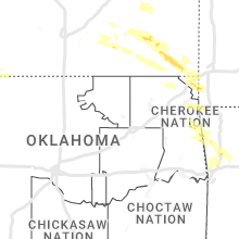
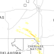
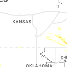
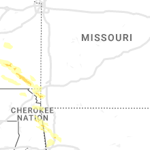
Hail Map for Thursday, September 7, 2023

Number of Impacted Households on 9/7/2023
0
Impacted by 1" or Larger Hail
0
Impacted by 1.75" or Larger Hail
0
Impacted by 2.5" or Larger Hail
Square Miles of Populated Area Impacted on 9/7/2023
0
Impacted by 1" or Larger Hail
0
Impacted by 1.75" or Larger Hail
0
Impacted by 2.5" or Larger Hail


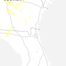


Cities Most Affected by Hail Storms of 9/7/2023
| Hail Size | Demographics of Zip Codes Affected | ||||||
|---|---|---|---|---|---|---|---|
| City | Count | Average | Largest | Pop Density | House Value | Income | Age |
| Jeffersonville, GA | 1 | 1.75 | 1.75 | 12 | $63k | $30.2k | 46.2 |
| Washington, GA | 1 | 1.75 | 1.75 | 27 | $68k | $28.4k | 42.7 |
| Boiling Springs, SC | 1 | 1.75 | 1.75 | 1116 | $99k | $48.0k | 35.5 |
Hail and Wind Damage Spotted on 9/7/2023
Filter by Report Type:Hail ReportsWind Reports
States Impacted
West Virginia, Maryland, South Dakota, Virginia, Pennsylvania, New York, North Carolina, New Jersey, Georgia, Vermont, South Carolina, Mississippi, Louisiana, Tennessee, Florida, New Hampshire, Nebraska, Maine, Connecticut, Massachusetts, Delaware, Kansas, MissouriWest Virginia
| Local Time | Report Details |
|---|---|
| 11:14 AM EDT | One tree down due to thunderstorm winds along the 7200 block of jersey mountain roa in hampshire county WV, 69.7 miles ENE of Elkins, WV |
| 11:49 AM EDT | There were several calls for multiple trees blown down in northeastern hardy county... including along cr-23/10 trout run road to near the national forest just outside in hardy county WV, 65.3 miles E of Elkins, WV |
| 11:50 AM EDT | There were several calls for trees blown down near paw pa in hampshire county WV, 84.6 miles ENE of Elkins, WV |
| 12:05 PM EDT | Quarter sized hail reported near Great Cacapon, WV, 86.8 miles SSW of State College, PA, public reports quarter-sized hail near great cacapon. |
| 12:10 PM EDT | There were several calls for trees blown down near augusta and frenchbur in hampshire county WV, 73.5 miles ENE of Elkins, WV |
| 1:05 PM EDT | Quarter sized hail reported near Hedgesville, WV, 82.1 miles W of Baltimore, MD, public reports quarter-sized hail in shanghai. time estimated from radar. |
| 1:10 PM EDT | Quarter sized hail reported near Hedgesville, WV, 81.3 miles W of Baltimore, MD, 1 inch hail along back creek valley road. time estimated from radar. |
| 1:10 PM EDT | Ping Pong Ball sized hail reported near Gerrardstown, WV, 79 miles W of Baltimore, MD, public reports hail of at least ping pong ball size east of shanghai along tuscarora pike. time estimated from radar. |
| 1:21 PM EDT | Quarter sized hail reported near Hedgesville, WV, 79.1 miles WNW of Baltimore, MD, quarter sized hail near back creek south of tomahawk... wv. time estimated from radar. |
| 1:27 PM EDT | Wires were brought down by a downed tree on panorama d in berkeley county WV, 72.8 miles WNW of Baltimore, MD |
| 1:28 PM EDT | Quarter sized hail reported near Martinsburg, WV, 70.8 miles WNW of Baltimore, MD, public reports quarter sized hail near intersection of berkeley station rd and bedington rd in berkeley... wv. time estimated from radar. |
| 1:32 PM EDT | Half Dollar sized hail reported near Martinsburg, WV, 73.4 miles WNW of Baltimore, MD, public estimated hail up to half dollar size near spring mills... wv. time estimated from radar. |
Maryland
| Local Time | Report Details |
|---|---|
| 11:54 AM EDT | Quarter sized hail reported near Oldtown, MD, 84.8 miles ENE of Elkins, WV, public estimates quarter-sized hail in paw paw. time estimated from radar. |
| 1:45 PM EDT | Trees blew down on eastbound i-70 dwight d. eisenhower highway near us-11 virginia avenu in washington county MD, 66.4 miles WNW of Baltimore, MD |
| 1:45 PM EDT | Trees blew down on eastbound i-70 dwight d. eisenhower highway near us-11 virginia avenu in washington county MD, 66.4 miles WNW of Baltimore, MD |
| 1:45 PM EDT | There were over a dozen calls for trees and wires blown down over central washington count in washington county MD, 69.6 miles WNW of Baltimore, MD |
| 1:45 PM EDT | Quarter sized hail reported near Williamsport, MD, 68.2 miles WNW of Baltimore, MD, wind-driven quarter size hail and measured wind gusts of over 65 knots (75 mph) were reported by a spotter on falling waters road in williamsport. the wind and hail tor |
| 1:45 PM EDT | Wind-driven quarter size hail and measured wind gusts of over 65 knots (75 mph) were reported by a spotter on falling waters road in williamsport. the wind and hail tor in washington county MD, 68.2 miles WNW of Baltimore, MD |
| 2:28 PM EDT | Trees blew down in southwestern frederick county near rosemont... brunswick... and knoxvill in frederick county MD, 55.3 miles W of Baltimore, MD |
| 2:34 PM EDT | Trees and wires blew down near the intersection of md-28 darnestown road and md-117 bucklodge roa in montgomery county MD, 41.4 miles WSW of Baltimore, MD |
| 2:35 PM EDT | Trees and wires blew down on md-27 ridge road at penn shop roa in howard county MD, 30.3 miles W of Baltimore, MD |
| 2:40 PM EDT | Quarter sized hail reported near Adamstown, MD, 46.1 miles W of Baltimore, MD, quarter size hail was reported in adamstown. |
| 2:40 PM EDT | Trees blew down on southbound i-270 dwight d. eisenhower highway before exit 18/md-121 stringtown roa in montgomery county MD, 36.7 miles W of Baltimore, MD |
| 2:42 PM EDT | Quarter sized hail reported near Adamstown, MD, 45.6 miles W of Baltimore, MD |
| 2:45 PM EDT | Trees blew down in central frederick county... including near frederick... braddock heights... ballenger creek... and middletow in frederick county MD, 46.8 miles W of Baltimore, MD |
| 2:59 PM EDT | Multiple trees down on wheyfield driv in frederick county MD, 42.7 miles WNW of Baltimore, MD |
| 3:00 PM EDT | Trees blew down in northeastern frederick county... including near woodsboro... lewistown... and keyma in frederick county MD, 43 miles WNW of Baltimore, MD |
| 3:12 PM EDT | Trees blew down along woodbine road and white rock roa in carroll county MD, 26.5 miles WNW of Baltimore, MD |
| 3:12 PM EDT | Trees blew down along woodbine road and white rock roa in carroll county MD, 26.5 miles WNW of Baltimore, MD |
| 3:25 PM EDT | Carroll county public schools had delayed dismissal due to roads closed from fallen trees and wire in carroll county MD, 29.6 miles NNW of Baltimore, MD |
| 3:33 PM EDT | A wind gust of 50 knots (58 mph) and quarter size hail was measured by a co-op observer in miller in carroll county MD, 31.3 miles NNW of Baltimore, MD |
| 3:33 PM EDT | Quarter sized hail reported near Manchester, MD, 31.3 miles NNW of Baltimore, MD, a wind gust of 50 knots (58 mph) and quarter size hail was measured by a co-op observer in millers. |
| 4:15 PM EDT | Ping Pong Ball sized hail reported near Baltimore, MD, 5.5 miles NNW of Baltimore, MD, ping pong ball size hail was reported in the mount washington area of baltimore city. |
| 4:30 PM EDT | Trees blew down around white hall and norrisville... including in the 4500 block of amos roa in harford county MD, 26.6 miles N of Baltimore, MD |
| 4:30 PM EDT | Quarter sized hail reported near Baltimore, MD, 6.2 miles N of Baltimore, MD, trained spotter reports 1 inch hail in towson. |
| 5:15 PM EDT | Trees blew down between bynum and bel air... including near the intersection of high point road and md-23 east-west highwa in harford county MD, 21.8 miles NNE of Baltimore, MD |
| 5:30 PM EDT | Quarter sized hail reported near Kensington, MD, 30.6 miles SW of Baltimore, MD, quarter size hail was reported in kensington. |
| 5:30 PM EDT | Montgomery county em relays report of downted trees on power lines along 3800th block of denfeld ave in kensingto in montgomery county MD, 30.2 miles SW of Baltimore, MD |
| 5:34 PM EDT | Montgomery county em reports trees and power lines down at 2610th block of newton street in silver sprin in montgomery county MD, 28.9 miles WSW of Baltimore, MD |
| 5:47 PM EDT | Quarter sized hail reported near Westminster, MD, 34.8 miles NW of Baltimore, MD, dime to quarter size hail was observed by a spotter in the 2400 block of cross section road. |
| 7:00 PM EDT | Quarter sized hail reported near Pylesville, MD, 30.7 miles NNE of Baltimore, MD, trees and branches blew down and nickel to quarter size hail was observed at fawn view farm on onion road in pylesville. |
| 7:00 PM EDT | Trees and branches blew down and nickel to quarter size hail was observed at fawn view farm on onion road in pylesvill in harford county MD, 30.7 miles NNE of Baltimore, MD |
| 7:22 PM EDT | Quarter sized hail reported near Hollywood, MD, 62.2 miles S of Baltimore, MD, quarter size hail was observed by trained spotters in the 43500 block of drum cliff road near the tidal patuxent river. |
| 4:23 AM EDT | Multiple trees down in the severna park are in anne arundel county MD, 14.7 miles S of Baltimore, MD |
South Dakota
| Local Time | Report Details |
|---|---|
| 10:32 AM MDT | Half Dollar sized hail reported near Fort Pierre, SD, 28 miles W of Pierre, SD |
Virginia
| Local Time | Report Details |
|---|---|
| 12:35 PM EDT | There were calls for trees blown down in gor in frederick county VA, 84.6 miles ENE of Elkins, WV |
| 12:59 PM EDT | A wind gust of 50 knots (58 mph) was measured by a personal weather station on springwood lane (kvasteph74 in frederick county VA, 87.7 miles E of Elkins, WV |
| 1:06 PM EDT | There was a call for a few trees blown down in chester ga in rappahannock county VA, 87.7 miles WSW of Baltimore, MD |
| 1:09 PM EDT | A wind gust of 54 knots (62 mph) was measured by a personal weather station at high knob tower (kvafront11 in warren county VA, 85.3 miles WSW of Baltimore, MD |
| 1:10 PM EDT | There were calls for trees blown down in stephens cit in frederick county VA, 87.4 miles W of Baltimore, MD |
| 1:15 PM EDT | There were about half a dozen calls for trees blown down in the linden are in warren county VA, 83.3 miles WSW of Baltimore, MD |
| 1:19 PM EDT | There were several calls for trees blown down along va-55 john marshall highway between linden and markha in fauquier county VA, 81.8 miles WSW of Baltimore, MD |
| 1:21 PM EDT | Trees blew down along va-55 john marshall highway near markha in fauquier county VA, 79.2 miles WSW of Baltimore, MD |
| 2:10 PM EDT | Quarter sized hail reported near Sterling, VA, 51.9 miles WSW of Baltimore, MD, quarter size hail was observed at the nws office in sterling. |
| 2:10 PM EDT | Trees blew down near waterford... including on northbound va-704 hamilton station road near va-9 charles town pik in loudoun county VA, 56 miles W of Baltimore, MD |
| 2:21 PM EDT | Quarter sized hail reported near Ashburn, VA, 49.8 miles WSW of Baltimore, MD, there were a few reports of quarter size hail in the ashburn area. |
| 2:22 PM EDT | Quarter sized hail reported near Sterling, VA, 46.6 miles WSW of Baltimore, MD |
| 3:35 PM EDT | Thunderstorm winds blew down a large tree into the roadway near the intersection of sleepy hollow road and cambria stree in montgomery county VA, 28.3 miles WSW of Roanoke, VA |
| 3:35 PM EDT | Tree was downed by thunderstorm winds and fell onto a power lin in montgomery county VA, 26.6 miles WSW of Roanoke, VA |
| 3:40 PM EDT | Around a dozen large trees down just south of blacksburg... as well as a power line near the intersection of jennelle road and south main street. time estimated from ra in montgomery county VA, 26.6 miles WSW of Roanoke, VA |
| 3:42 PM EDT | Quarter sized hail reported near Christiansburg, VA, 26.6 miles WSW of Roanoke, VA |
| 3:44 PM EDT | Thunderstorm winds blew down a tree near the intersection of jennelle road and yellow sulphur roa in montgomery county VA, 26.1 miles WSW of Roanoke, VA |
| 3:45 PM EDT | Downed trees and wires caused a power outage near delaplan in fauquier county VA, 77.2 miles WSW of Baltimore, MD |
| 3:46 PM EDT | Delaplane fire dept responded to several calls of downed trees and wire in fauquier county VA, 74.9 miles WSW of Baltimore, MD |
| 3:58 PM EDT | Quarter sized hail reported near Upperville, VA, 72.5 miles WSW of Baltimore, MD |
| 4:00 PM EDT | Quarter sized hail reported near Ashburn, VA, 53.1 miles WSW of Baltimore, MD, at least quarter size hail was observed near brambleton. |
| 4:37 PM EDT | Tree down at intersection of electric road and greenridge road. time estimated from rada in city of salem county VA, 5.6 miles WNW of Roanoke, VA |
| 4:41 PM EDT | Thunderstorm winds blew down a tree into a power line on barnett road n in city of roanoke county VA, 4.8 miles WNW of Roanoke, VA |
| 4:45 PM EDT | Very large tree snapped near base and caused minor damage to an outdoor dec in roanoke county VA, 5.7 miles SW of Roanoke, VA |
| 4:50 PM EDT | Quarter sized hail reported near Roanoke, VA, 5 miles NNW of Roanoke, VA |
| 5:10 PM EDT | Tree down resulting in power outages. time estimated from rada in mecklenburg county VA, 58.9 miles N of Raleigh, NC |
| 6:01 PM EDT | Quarter sized hail reported near Crewe, VA, 34.6 miles SW of Richmond, VA, mutiple videos/pictures of approximately quarter sized hail in and around the town of crewe. time estimated from radar. |
| 6:30 PM EDT | Quarter sized hail reported near Amelia Court House, VA, 21.2 miles SW of Richmond, VA, report via social media. time estimated from radar. |
| 6:35 PM EDT | Quarter sized hail reported near Aylett, VA, 32.5 miles NE of Richmond, VA, report via facebook. time estimated from radar. |
| 7:09 PM EDT | A large tree limb fell into a house in the chesterfield courthouse area. in addition... hail was estimated to be around 1 inch. time estimated from rada in chesterfield county VA, 11.9 miles SE of Richmond, VA |
| 7:10 PM EDT | Report from mping: trees uprooted or snappe in chesterfield county VA, 6.5 miles S of Richmond, VA |
| 7:11 PM EDT | Multiple trees uprooted and a tree has been knocked down into a home. time estimated from rada in chesterfield county VA, 5.9 miles SE of Richmond, VA |
| 7:16 PM EDT | Tree knocked down across the roadway. time estimated from rada in chesterfield county VA, 4.6 miles ESE of Richmond, VA |
| 7:24 PM EDT | Quarter sized hail reported near Alton, VA, 61.8 miles NNW of Raleigh, NC |
| 7:25 PM EDT | Quarter sized hail reported near Alton, VA, 61.8 miles NNW of Raleigh, NC, quarter sized hail was reported at the virginia international raceway. |
| 7:30 PM EDT | Significant tree damage across the northern portion of the county in particular with multiple trees into houses. in addition... approximately 200f the county is witho in city of richmond county VA, 5.9 miles ENE of Richmond, VA |
| 7:30 PM EDT | Report from mping: 3-inch tree limbs broken; power poles broke in henrico county VA, 14.3 miles ENE of Richmond, VA |
| 7:31 PM EDT | Tree knocked down... blocking colts neck rd. time estimated from rada in hanover county VA, 20.9 miles ENE of Richmond, VA |
| 7:31 PM EDT | 2 trees knocked down. time estimated from rada in city of richmond county VA, 10.7 miles ENE of Richmond, VA |
| 7:34 PM EDT | Quarter sized hail reported near Aylett, VA, 35.5 miles NE of Richmond, VA, report via twitter. time estimated from radar. |
| 7:35 PM EDT | Tree knocked down along i-195n. time estimated from rada in city of richmond county VA, 9.7 miles ENE of Richmond, VA |
| 7:40 PM EDT | Several large (+3-inch diameter) tree limbs snapped/broken near intersection of staples mill rd and waller r in henrico county VA, 10.7 miles NE of Richmond, VA |
| 7:45 PM EDT | Report from mping: trees uprooted or snappe in city of richmond county VA, 14.4 miles E of Richmond, VA |
| 7:50 PM EDT | Tree knocked down on a powerline resulting in power outage. time estimated from rada in chesterfield county VA, 20.5 miles ESE of Richmond, VA |
| 8:00 PM EDT | Report from mping: trees uprooted or snappe in henrico county VA, 14.8 miles ENE of Richmond, VA |
| 8:16 PM EDT | Tree knocked down along old church rd. time estimated from rada in new kent county VA, 32 miles E of Richmond, VA |
| 9:57 PM EDT | A few trees were downed by thunderstorm winds in the 2900 block of old route 100 roa in pulaski county VA, 45.9 miles WSW of Roanoke, VA |
| 10:00 PM EDT | Tree downed by thunderstorm winds in hillsvill in carroll county VA, 55.7 miles SW of Roanoke, VA |
| 10:16 PM EDT | A power line was downed by thunderstorm winds near the intersection of maplewood avenue and henry stree in henry county VA, 36.7 miles S of Roanoke, VA |
| 10:26 PM EDT | Powerlines down across philpott driv in henry county VA, 32.5 miles S of Roanoke, VA |
| 11:00 PM EDT | Two trees down across terrys mountain roa in henry county VA, 39.3 miles S of Roanoke, VA |
| 11:16 PM EDT | Several trees were downed by thunderstorm winds in the rocky mount are in franklin county VA, 19 miles S of Roanoke, VA |
Pennsylvania
| Local Time | Report Details |
|---|---|
| 1:10 PM EDT | Tree down on roadwa in huntingdon county PA, 28.9 miles S of State College, PA |
| 1:17 PM EDT | Quarter sized hail reported near Kutztown, PA, 62.4 miles S of Scranton, PA, trained spotter reports quarter sized hail with dime size mixing in on kutztown university campus. |
| 1:21 PM EDT | Trees down on roadwa in huntingdon county PA, 17.6 miles S of State College, PA |
| 1:25 PM EDT | Half Dollar sized hail reported near Kutztown, PA, 61.7 miles S of Scranton, PA, trained spotter reports 1.25 inch hail in kutztown. |
| 1:37 PM EDT | Trees and wires down on pension hollow roa in perry county PA, 37.6 miles SE of State College, PA |
| 1:40 PM EDT | Quarter sized hail reported near Kutztown, PA, 57.4 miles S of Scranton, PA, picture sent in of quarter-sized hail in new smithville... pa. time estimated from radar. |
| 2:00 PM EDT | Multiple trees down on route 32 in centre county PA, 11.6 miles E of State College, PA |
| 2:02 PM EDT | Multiple trees down on route 4 in centre county PA, 11 miles ENE of State College, PA |
| 2:04 PM EDT | Multiple trees and power poles dow in centre county PA, 16.9 miles ENE of State College, PA |
| 2:16 PM EDT | Trees and wires just off of hunters valley roa in perry county PA, 48 miles ESE of State College, PA |
| 2:19 PM EDT | Trees and wires down in hamburg. time estimated from rada in berks county PA, 61 miles SSW of Scranton, PA |
| 2:33 PM EDT | Powerlines dow in wayne county PA, 13 miles E of Scranton, PA |
| 2:50 PM EDT | Trees and wires down on route 4 in lycoming county PA, 43.9 miles NE of State College, PA |
| 2:53 PM EDT | Tree down on a car in porter townshi in lycoming county PA, 41.6 miles NE of State College, PA |
| 2:58 PM EDT | Multiple trees and wires down along burnt house roa in cumberland county PA, 56.9 miles SE of State College, PA |
| 3:05 PM EDT | Numerous trees and wires down north of shermansdal in perry county PA, 47.1 miles SE of State College, PA |
| 3:19 PM EDT | Quarter sized hail reported near Duncannon, PA, 51.4 miles ESE of State College, PA, broadcast partner reports 1 inch hail in duncannon. |
| 3:20 PM EDT | Trees and wires dow in lycoming county PA, 52.8 miles NE of State College, PA |
| 3:25 PM EDT | Quarter sized hail reported near Hazleton, PA, 35.6 miles SSW of Scranton, PA |
| 3:27 PM EDT | Spotter reports large amounts of tree debris across state route 5 in northumberland county PA, 59.1 miles SW of Scranton, PA |
| 3:34 PM EDT | Trees and wires dow in luzerne county PA, 35.8 miles SW of Scranton, PA |
| 3:40 PM EDT | Multiple trees and wires down in minersvill in schuylkill county PA, 58.7 miles SSW of Scranton, PA |
| 3:50 PM EDT | Trees and wires down on rocky road in manheim tw in york county PA, 33.8 miles NNW of Baltimore, MD |
| 3:55 PM EDT | Trees and wires down on conewago road in dover tw in york county PA, 52.3 miles NNW of Baltimore, MD |
| 4:01 PM EDT | Tree and power lines dow in luzerne county PA, 22.4 miles SW of Scranton, PA |
| 4:05 PM EDT | Trees and wires dow in luzerne county PA, 26.2 miles SW of Scranton, PA |
| 4:06 PM EDT | Trees and wires down in highspir in dauphin county PA, 64.1 miles N of Baltimore, MD |
| 4:10 PM EDT | Tree down on roa in luzerne county PA, 22.5 miles SW of Scranton, PA |
| 4:11 PM EDT | Tree down on roa in luzerne county PA, 23.3 miles SW of Scranton, PA |
| 4:19 PM EDT | Trees down with power outage in luzerne county PA, 17.6 miles WSW of Scranton, PA |
| 4:25 PM EDT | Trees down blocking swatara drive in east hanover tw in lebanon county PA, 74.6 miles N of Baltimore, MD |
| 4:27 PM EDT | Multiple trees dow in luzerne county PA, 20.3 miles W of Scranton, PA |
| 4:28 PM EDT | Large tree down blocking the on ramp to route 7 in lebanon county PA, 67.6 miles N of Baltimore, MD |
| 4:30 PM EDT | Trees on wire in lebanon county PA, 74.1 miles ESE of State College, PA |
| 4:32 PM EDT | Tree down on gravel pond roa in lackawanna county PA, 6.9 miles NNW of Scranton, PA |
| 4:32 PM EDT | Tree down on grove stree in lackawanna county PA, 6.3 miles NW of Scranton, PA |
| 4:36 PM EDT | Tree down on hous in wyoming county PA, 25.4 miles WNW of Scranton, PA |
| 4:38 PM EDT | Tree on wire in susquehanna county PA, 23.9 miles NNW of Scranton, PA |
| 4:40 PM EDT | Multiple trees down on hunter highwa in wyoming county PA, 17.9 miles WNW of Scranton, PA |
| 4:44 PM EDT | Trees and wires down along melvin driv in lancaster county PA, 49.2 miles NNE of Baltimore, MD |
| 4:51 PM EDT | Wires dow in susquehanna county PA, 26.1 miles NW of Scranton, PA |
| 4:55 PM EDT | Two trees down with wires across roa in susquehanna county PA, 31.7 miles NNW of Scranton, PA |
| 4:57 PM EDT | Two trees down... wire across roa in susquehanna county PA, 31.1 miles NNW of Scranton, PA |
| 4:57 PM EDT | Trees down on wires along manheim pike at the lancaster city lin in lancaster county PA, 55.8 miles NNE of Baltimore, MD |
| 4:59 PM EDT | *** 1 fatal *** corrects previous tstm wnd dmg report from 1 ne montrose. tree down on male with injuries. *updated the report as new information verified that the vict in susquehanna county PA, 32.1 miles NNW of Scranton, PA |
| 5:01 PM EDT | Delayed report... large tree down partially blocking one lane of penn avenue in wernersville. time estimated from rada in berks county PA, 77 miles NNE of Baltimore, MD |
| 5:07 PM EDT | Tree down... blocking travel lan in susquehanna county PA, 36.5 miles NNW of Scranton, PA |
| 5:12 PM EDT | Jcpl reports tree damage resulting in power outages along weisenberg church road near new smithville. time estimated from rada in lehigh county PA, 57.4 miles S of Scranton, PA |
| 5:13 PM EDT | Trees and wires down along lowry road in earl tw in lancaster county PA, 61.2 miles NNE of Baltimore, MD |
| 5:13 PM EDT | Wires down on roa in lancaster county PA, 60.9 miles NNE of Baltimore, MD |
| 5:13 PM EDT | Tree down... taking wires and utility box with i in susquehanna county PA, 38.9 miles N of Scranton, PA |
| 5:13 PM EDT | Tree dow in susquehanna county PA, 42.4 miles NNW of Scranton, PA |
| 5:15 PM EDT | Tree down with debris in roa in susquehanna county PA, 36.7 miles N of Scranton, PA |
| 5:20 PM EDT | Jcpl reports tree damage resulting in power outages along weisenberg church road. time estimated from rada in lehigh county PA, 53.2 miles S of Scranton, PA |
| 5:27 PM EDT | Tree limbs down on wires on vinemont road. time estimated from rada in berks county PA, 73.2 miles NNE of Baltimore, MD |
| 5:34 PM EDT | Several reports of large branches and power lines down in north whitehall township. time estimated from rada in lehigh county PA, 49.8 miles S of Scranton, PA |
| 5:39 PM EDT | Multiple trees and wires down across storms store road in mt. pleasant tw in adams county PA, 44.6 miles NW of Baltimore, MD |
| 5:40 PM EDT | Large pine tree snapped from strong outflow winds. time estimated from rada in northampton county PA, 51 miles SSE of Scranton, PA |
| 5:42 PM EDT | Picture of a large tree snapped on broad street in tatamy associated with gust front. time estimated from rada in northampton county PA, 51 miles SSE of Scranton, PA |
| 5:42 PM EDT | Downed tree in wires on hamilton s near saylorsburg. time estimated from rada in monroe county PA, 39.4 miles SSE of Scranton, PA |
| 5:43 PM EDT | Tree down in wires at raubsville road and deemer road from strong outflow winds.time estimated from rada in northampton county PA, 58.6 miles SSE of Scranton, PA |
| 5:45 PM EDT | Large maple tree down. snapped across trunk. minor house damage. telecom wires down. power lines unaffecte in lehigh county PA, 56.1 miles SSE of Scranton, PA |
| 5:46 PM EDT | Trained spotter measured 61 mph wind gust with anemometer associated with gust front. time estimate in northampton county PA, 53 miles SSE of Scranton, PA |
| 5:46 PM EDT | Large branches... trees... and power lines down and burning near river road and harmony station road. time estimated from rada in warren county NJ, 52.4 miles SSE of Scranton, PA |
| 5:50 PM EDT | Downed tree in wires near dreher ave and glen brook road. time estimated from rada in monroe county PA, 37.9 miles SE of Scranton, PA |
| 5:50 PM EDT | Tree down in wires on pa 611 at mount pleasant road from strong outflow winds. time estimated from rada in northampton county PA, 49 miles SSE of Scranton, PA |
| 5:51 PM EDT | Downed tree in wires on cherry valley road. time estimated from rada in monroe county PA, 39.4 miles SE of Scranton, PA |
| 6:00 PM EDT | Corrects previous tstm wnd dmg report from 1 sse stroudsburg. downed tree in wires on cherry valley road. time estimated from rada in monroe county PA, 39.4 miles SE of Scranton, PA |
| 6:05 PM EDT | Quarter sized hail reported near Coatesville, PA, 63.5 miles NE of Baltimore, MD, picture of 1 inch hail measured in coatesville. time estimated. |
| 6:21 PM EDT | Trees and wires down across iron stone hill road in york tw in york county PA, 41.5 miles N of Baltimore, MD |
| 6:54 PM EDT | Wires down on south main street of east prospect borough near west ridge avenue. time estimated by rada in york county PA, 47.1 miles N of Baltimore, MD |
| 7:12 PM EDT | Wires down on richmond road. time estimated by rada in lancaster county PA, 52.1 miles NNE of Baltimore, MD |
New York
| Local Time | Report Details |
|---|---|
| 1:43 PM EDT | Half Dollar sized hail reported near Willsboro, NY, 9.4 miles WSW of Burlington, VT |
| 2:50 PM EDT | Single tree down on roadway in tow in essex county NY, 32.7 miles SSW of Burlington, VT |
| 3:36 PM EDT | Quarter sized hail reported near Afton, NY, 57 miles N of Scranton, PA |
| 3:41 PM EDT | Multiple trees dow in essex county NY, 13.3 miles SSW of Burlington, VT |
| 3:41 PM EDT | Multiple trees dow in essex county NY, 11.8 miles SW of Burlington, VT |
| 4:06 PM EDT | Tree and wires dow in delaware county NY, 64.3 miles NNE of Scranton, PA |
| 4:38 PM EDT | A couple of trees down in the town of summit near clapper hollow in schoharie county NY, 43.2 miles WSW of Schenectady, NY |
| 4:40 PM EDT | Multiple trees down around oweg in tioga county NY, 56.8 miles NNW of Scranton, PA |
| 4:45 PM EDT | Multiple trees and wires dow in broome county NY, 48.8 miles NNW of Scranton, PA |
| 4:45 PM EDT | Tree and wires dow in broome county NY, 48.1 miles NNW of Scranton, PA |
| 4:50 PM EDT | Multiple trees down and power poles snappe in broome county NY, 48.8 miles NNW of Scranton, PA |
| 4:55 PM EDT | Tree down on the roa in broome county NY, 44.2 miles N of Scranton, PA |
| 5:03 PM EDT | Tree on powerline near the transfer station in guilderlan in albany county NY, 7.8 miles S of Schenectady, NY |
| 5:05 PM EDT | Tree down on occupied camper. unknown injurie in broome county NY, 46.9 miles S of Syracuse, NY |
| 5:20 PM EDT | Several trees down across roa in cortland county NY, 43.2 miles S of Syracuse, NY |
| 5:22 PM EDT | Tree down on route 8 in johnsburg. time estimated from rada in warren county NY, 55.8 miles N of Schenectady, NY |
| 5:24 PM EDT | Tree and wires dow in cortland county NY, 43.5 miles S of Syracuse, NY |
| 5:28 PM EDT | Tree and wires down on roa in cortland county NY, 42.9 miles S of Syracuse, NY |
| 5:31 PM EDT | Tree and wires down on roa in cortland county NY, 35.2 miles SSE of Syracuse, NY |
| 5:41 PM EDT | Quarter sized hail reported near Clifton Park, NY, 7.1 miles ENE of Schenectady, NY, report of quarter size hail |
| 5:55 PM EDT | Tree down on roa in otsego county NY, 64.8 miles SE of Syracuse, NY |
| 6:00 PM EDT | Tree down blocking the road. time estimated from rada in cayuga county NY, 23.6 miles SSW of Syracuse, NY |
| 6:01 PM EDT | Quarter sized hail reported near Saratoga Springs, NY, 15.4 miles NE of Schenectady, NY, received a report of dime to quarter size inch hail near stillwater. |
| 6:01 PM EDT | Quarter sized hail reported near Ballston Spa, NY, 13.3 miles NE of Schenectady, NY, received a report of nickel to quarter size inch hail near the malta community center. |
| 6:05 PM EDT | Wires down on route 75 and burrello court in saratoga county NY, 16.8 miles NE of Schenectady, NY |
| 6:05 PM EDT | Wires down on lake road and grace moore roa in saratoga county NY, 16.1 miles NE of Schenectady, NY |
| 6:05 PM EDT | Tree down on roa in chenango county NY, 39.7 miles SE of Syracuse, NY |
| 6:05 PM EDT | Tree down on roa in otsego county NY, 56.7 miles SE of Syracuse, NY |
| 6:07 PM EDT | Trees and wires down on gronczniak roa in saratoga county NY, 18.9 miles NE of Schenectady, NY |
| 6:09 PM EDT | Wires down on union ave and henning roa in saratoga county NY, 20.9 miles NNE of Schenectady, NY |
| 6:10 PM EDT | Tree on house on neilson ave in saratoga county NY, 19.7 miles NE of Schenectady, NY |
| 6:11 PM EDT | Trees and wires down on wright town road in saratoga county NY, 19.1 miles NE of Schenectady, NY |
| 6:13 PM EDT | Tree down on roa in otsego county NY, 66.1 miles SE of Syracuse, NY |
| 6:13 PM EDT | Tree down on roa in otsego county NY, 64.6 miles SE of Syracuse, NY |
| 6:15 PM EDT | Tree down on roa in otsego county NY, 57.2 miles SE of Syracuse, NY |
| 6:25 PM EDT | Trees down near stevens road and grant ave... relayed by nws bu in cayuga county NY, 18 miles W of Syracuse, NY |
| 6:58 PM EDT | Corrects report source in previous tstm wnd dmg report from fulton. tree down on west 4th street in fulto in oswego county NY, 22.6 miles NW of Syracuse, NY |
| 6:58 PM EDT | Corrects report source in previous tstm wnd dmg report from fulton. tree down on west 4th street in fulto in oswego county NY, 22.6 miles NW of Syracuse, NY |
| 6:58 PM EDT | Tree down at state route 49 and canterbury way in hasting in oswego county NY, 16.6 miles N of Syracuse, NY |
| 7:04 PM EDT | Wires down near state route 46 and walker roa in oneida county NY, 25.3 miles ENE of Syracuse, NY |
| 7:04 PM EDT | Tree down at state route 3 and beesaw r in oswego county NY, 21.5 miles NNW of Syracuse, NY |
| 7:06 PM EDT | Tree down on red schoolhouse r in oswego county NY, 22.3 miles NNW of Syracuse, NY |
| 7:11 PM EDT | Trees and wires dow in herkimer county NY, 57.4 miles E of Syracuse, NY |
| 7:11 PM EDT | Multiple trees and wires dow in herkimer county NY, 59.2 miles WNW of Schenectady, NY |
| 7:14 PM EDT | Wires down and burning on route 211 east between hidden valley drive and goshen turnpik in orange county NY, 56.5 miles NNW of Brooklyn, NY |
| 7:17 PM EDT | Quarter sized hail reported near Bloomingburg, NY, 64.6 miles NNW of Brooklyn, NY |
| 7:23 PM EDT | Tree down on marsh roa in oneida county NY, 23.6 miles NE of Syracuse, NY |
| 7:23 PM EDT | Tree and wires down at 380 bullville roa in orange county NY, 61.9 miles NNW of Brooklyn, NY |
| 7:25 PM EDT | Trees and wires down. time radar estimate in ulster county NY, 68.8 miles ENE of Scranton, PA |
| 7:29 PM EDT | Tree down on north jefferson st in pulask in oswego county NY, 35.9 miles N of Syracuse, NY |
| 7:30 PM EDT | Tree and wires down at woodcock mountain road and adelaide lan in orange county NY, 50.7 miles N of Brooklyn, NY |
| 7:30 PM EDT | Tree down on house per photo on social medi in dutchess county NY, 55.7 miles N of Brooklyn, NY |
| 7:32 PM EDT | Tree down at county route 17 and waterbury rd in redfiel in oswego county NY, 36.4 miles NNE of Syracuse, NY |
| 7:32 PM EDT | Trees and wires down on mccaw rd in redfiel in oswego county NY, 36.9 miles NNE of Syracuse, NY |
| 7:36 PM EDT | Trees and wires down. time radar estimate in ulster county NY, 71.1 miles SSW of Schenectady, NY |
| 7:38 PM EDT | Trees and wires down. time radar estimate in ulster county NY, 65.9 miles NNW of Brooklyn, NY |
| 7:38 PM EDT | Wires down. time radar estimate in ulster county NY, 66.7 miles NNW of Brooklyn, NY |
| 7:41 PM EDT | Wires down at 1224 route 17 in orange county NY, 59 miles NNW of Brooklyn, NY |
| 7:43 PM EDT | Tree and wires burning at 539 route 3 in orange county NY, 60.7 miles N of Brooklyn, NY |
| 7:44 PM EDT | Tree on house. time radar estimate in ulster county NY, 64 miles N of Brooklyn, NY |
| 7:50 PM EDT | Downed tree. time radar estimate in greene county NY, 38.3 miles SSW of Schenectady, NY |
| 7:50 PM EDT | Tree down on wires at old mill stree in orange county NY, 51.7 miles N of Brooklyn, NY |
| 7:50 PM EDT | Rt 22 closed between rt 43 and wyomanock rd due to downed trees and wires in the roadway. time estimated from rada in rensselaer county NY, 31.3 miles SE of Schenectady, NY |
| 8:11 PM EDT | Tree down blocking hodge rd in the town of watso in lewis county NY, 61.1 miles S of Ogdensburg, NY |
| 8:15 PM EDT | Storm damage reported in columbia county NY, 53.1 miles SSE of Schenectady, NY |
| 8:30 PM EDT | Time estimated from rada in columbia county NY, 39.4 miles SE of Schenectady, NY |
| 8:30 PM EDT | Storm damage reported in rensselaer county NY, 23 miles SE of Schenectady, NY |
| 8:36 PM EDT | Storm damage reported in columbia county NY, 36.1 miles SSE of Schenectady, NY |
| 8:39 PM EDT | Road closed due to downed tree on wires. time radar estimate in schenectady county NY, 3.5 miles ESE of Schenectady, NY |
| 8:42 PM EDT | Trees and wires downed on lake nebo road in washington county NY, 47.4 miles NNE of Schenectady, NY |
| 8:45 PM EDT | Tree down on davis av in albany county NY, 11.9 miles SE of Schenectady, NY |
| 8:49 PM EDT | Wires down on burgoyne road in saratoga county NY, 24.8 miles NE of Schenectady, NY |
| 8:50 PM EDT | Rt 22 closed between rt 43 and wyomanock rd due to downed trees and wires in the roadway. time estimated from rada in rensselaer county NY, 31.3 miles SE of Schenectady, NY |
| 9:14 PM EDT | Tree on wires. time radar estimate in washington county NY, 35 miles ENE of Schenectady, NY |
| 9:15 PM EDT | Reports of multiple trees and power lines down in hoosick resulting in numerous power outages. time estimated from rada in rensselaer county NY, 31.2 miles E of Schenectady, NY |
| 9:16 PM EDT | Tree down. time radar estimate in washington county NY, 34.8 miles ENE of Schenectady, NY |
North Carolina
| Local Time | Report Details |
|---|---|
| 2:35 PM EDT | County 911 reports trees down at hwy 191 and n. rugby r in henderson county NC, 37.4 miles N of Greenville, SC |
| 6:19 PM EDT | Trees and limbs down on power line in rutherford county NC, 56.5 miles NE of Greenville, SC |
| 6:24 PM EDT | Quarter sized hail reported near Bessemer City, NC, 27.7 miles W of Charlotte, NC, image of 1 inch hail on social media. |
| 6:32 PM EDT | A few trees and power lines down in frankli in macon county NC, 50.3 miles WNW of Greenville, SC |
| 6:50 PM EDT | Quarter sized hail reported near Matthews, NC, 16 miles SSE of Charlotte, NC, time estimated from radar. |
| 6:52 PM EDT | Quarter sized hail reported near Matthews, NC, 17.5 miles SSE of Charlotte, NC, time estimated from radar. |
| 7:05 PM EDT | Trees and limbs down on power line in mecklenburg county NC, 15.4 miles NNW of Charlotte, NC |
| 7:45 PM EDT | Trees down at rhodhiss rd and knob av in burke county NC, 51.7 miles NW of Charlotte, NC |
| 8:20 PM EDT | Several trees were downed by thunderstorm winds near the intersection of shingle gap road and charity church road near lovette home in wilkes county NC, 59.4 miles ESE of Bristol, TN |
| 8:20 PM EDT | Tree down near intersection of nc hwy 73 and walker r in cabarrus county NC, 24.4 miles NE of Charlotte, NC |
| 9:44 PM EDT | Tree downed by thunderstorm winds along us 421 near the wilkes/watauga county lin in wilkes county NC, 49.9 miles ESE of Bristol, TN |
New Jersey
| Local Time | Report Details |
|---|---|
| 2:42 PM EDT | Half Dollar sized hail reported near Columbia, NJ, 41.5 miles SE of Scranton, PA, pictures sent in of quarter to half dollar sized hail. time estimated from radar. |
| 6:27 PM EDT | Trained spotter reports 2 trees with wires down on mitchell road in hackettstow in warren county NJ, 45.2 miles WNW of Brooklyn, NY |
| 6:28 PM EDT | Trained spotter reports of wires down on louis ln in hackettstow in warren county NJ, 45 miles WNW of Brooklyn, NY |
| 6:32 PM EDT | Report of a tree down blocking a road in whitehall. time estimated from rada in sussex county NJ, 43.7 miles WNW of Brooklyn, NY |
| 6:37 PM EDT | Report of trees down on wires near the byram shoprite. time estimated from rada in sussex county NJ, 41.6 miles WNW of Brooklyn, NY |
| 6:45 PM EDT | Received several photos from a trained spotter of several trees down at pleasant acres campground in wantage. time estimate in sussex county NJ, 52.4 miles NW of Brooklyn, NY |
| 6:49 PM EDT | Trees down at the intersection of route 23 and route 519. time estimated from rada in sussex county NJ, 52.7 miles NW of Brooklyn, NY |
Georgia
| Local Time | Report Details |
|---|---|
| 2:55 PM EDT | Golf Ball sized hail reported near Washington, GA, 47.5 miles WNW of Augusta, GA, emergency manager reported golf ball sized hail large enough to crack a windshield on hwy 49 near hwy 195. |
| 2:58 PM EDT | Emergency manager reported a tree down at the 100 block of westbrook r in wilkinson county GA, 84 miles SE of Atlanta, GA |
| 2:59 PM EDT | Emergency manager reported a tree down on ridge rd near the intersection with hwy 5 in twiggs county GA, 81.3 miles SE of Atlanta, GA |
| 3:00 PM EDT | Corrects previous tstm wnd dmg report from 1 sw gordon. emergency manager reported a tree down on the roadway on hwy 18 in gordon... near state spur 1 in wilkinson county GA, 85.3 miles SE of Atlanta, GA |
| 3:20 PM EDT | Emergency manager reported a tree down on the roadway on hwy 18 in gordon... near state spur 1 in wilkinson county GA, 85.3 miles SE of Atlanta, GA |
| 3:55 PM EDT | A tree was down blocking all westbound lanes of interstate 20 at mile marker 190... near lewiston r in columbia county GA, 12.4 miles W of Augusta, GA |
| 3:56 PM EDT | Tree and power line down on scotts ferry rd near scotts ferry trail. time estimate in columbia county GA, 20.1 miles WNW of Augusta, GA |
| 3:58 PM EDT | Quarter sized hail reported near Augusta, GA, 10.7 miles W of Augusta, GA, amateur radio operator forwarded a report of quarter sized hail at old belair rd. specific location not provided. time estimated by radar. |
| 4:00 PM EDT | A tree was downed at rickerson rd and powell rd. time estimate in richmond county GA, 9.6 miles W of Augusta, GA |
| 4:18 PM EDT | Multiple trees were downed near the intersection of round oak juliette rd and ga hwy 1 in jones county GA, 61.7 miles SE of Atlanta, GA |
| 4:18 PM EDT | A few trees were downed on round oak juliette rd near the federal wildlife refuge office in jones county GA, 61.1 miles SE of Atlanta, GA |
| 4:24 PM EDT | Tree and power line down on clarks hill rd (us hwy 221) and lake springs rd. time estimate in columbia county GA, 19.3 miles NW of Augusta, GA |
| 4:50 PM EDT | Quarter sized hail reported near Eastman, GA, 53.6 miles NNW of Douglas, GA, public report of quarter-sized hail on the 800 block of chester hwy. the hail lasted 6-7 minutes over this location. |
| 5:04 PM EDT | Quarter sized hail reported near Gray, GA, 69.7 miles SE of Atlanta, GA, multiple reports of quarter sized hail were made in the area of upper river rd near the river north subdivision. |
| 5:15 PM EDT | Quarter sized hail reported near Perry, GA, 82.8 miles NW of Douglas, GA, public reported 1 inch hail on kendall ct. |
| 5:20 PM EDT | Ping Pong Ball sized hail reported near Perry, GA, 84.8 miles NW of Douglas, GA, public report of ping pong sized hail near the intersection of langston rd and lake joy rd. |
| 5:25 PM EDT | Emergency manager reported a few trees down on riggins mill rd near the ga-87 connector and hwy 8 in bibb county GA, 78.6 miles SE of Atlanta, GA |
| 5:35 PM EDT | Emergency manager reported two trees down on horse shoe r in telfair county GA, 26.5 miles N of Douglas, GA |
| 5:51 PM EDT | Emergency manager reported a tree down on marion-ripley rd near hwy 8 in twiggs county GA, 90.1 miles NNW of Douglas, GA |
| 5:55 PM EDT | Emergency manager reported a tree down near the intersection of bullard rd and marion-ripley r in twiggs county GA, 86.7 miles NNW of Douglas, GA |
| 6:05 PM EDT | Quarter sized hail reported near Macon, GA, 82.6 miles SSE of Atlanta, GA, trained spotter reported quarter sized hail on liberty estates drive. |
| 6:18 PM EDT | Grady 911 reports numerous reports of trees and powerlines down in cair in grady county GA, 30.6 miles N of Tallahassee, FL |
| 6:22 PM EDT | Emergency manager reported metal roofing removed from a carport and damage to the roof of a barn on the 1500 block of hwy 35 in twiggs county GA, 80.3 miles NNW of Douglas, GA |
| 6:22 PM EDT | Golf Ball sized hail reported near Jeffersonville, GA, 79.6 miles NNW of Douglas, GA, emergency manager reported golf ball sized hail on hwy 358 near woodland rd. |
Vermont
| Local Time | Report Details |
|---|---|
| 3:07 PM EDT | Trees down on severance road in colchester... vt in chittenden county VT, 4.3 miles ENE of Burlington, VT |
| 3:09 PM EDT | Storm damage reported in chittenden county VT, 0.4 miles NW of Burlington, VT |
| 3:51 PM EDT | Tree down into powerlines on little river road and tree down in kneeland flat in washington county VT, 24.8 miles ESE of Burlington, VT |
| 4:30 PM EDT | Trees and power lines down south of rt 101 and rt 242 intersectio in orleans county VT, 49.6 miles NE of Burlington, VT |
| 5:23 PM EDT | Tree down into power lines at intersection of scott hill and east road in washington county VT, 36.4 miles ESE of Burlington, VT |
South Carolina
| Local Time | Report Details |
|---|---|
| 3:43 PM EDT | Half Dollar sized hail reported near Greenwood, SC, 50.3 miles SE of Greenville, SC, also a few tree limbs down. |
| 4:11 PM EDT | Tree down on a power line at 4200 hwy 28 n... near wideman cemetery rd. time estimate in mccormick county SC, 38.7 miles NW of Augusta, GA |
| 4:20 PM EDT | Tree down at bell field rd and bradley rd. time estimate in mccormick county SC, 37.2 miles NNW of Augusta, GA |
| 4:25 PM EDT | Tree down across humbert rd. time estimated from rada in laurens county SC, 31.4 miles SE of Greenville, SC |
| 4:30 PM EDT | Tree down at w martintown rd and currytown rd. hail of unknown size also reported. time estimate in edgefield county SC, 8.7 miles NNW of Augusta, GA |
| 4:34 PM EDT | Trees and tree limbs down on power line in greenwood county SC, 37 miles NNW of Augusta, GA |
| 4:34 PM EDT | Trees and limbs down on power line in greenwood county SC, 42.6 miles N of Augusta, GA |
| 4:38 PM EDT | Quarter sized hail reported near Modoc, SC, 19.4 miles NNW of Augusta, GA, broadcast media relayed a video of hail falling at a residence near the intersection of key rd. and hwy 23. largest stones are estimated to be quarter sized based on vi |
| 4:38 PM EDT | Trees and limbs down on power line in greenwood county SC, 43.4 miles SSE of Greenville, SC |
| 4:46 PM EDT | Tree down near pine pleasant church on old cherokee trail... between old saluda rd and kempson bridge rd. time estimate in saluda county SC, 47.3 miles NNE of Augusta, GA |
| 4:50 PM EDT | Tree down on ira kinard rd. exact location not given. time estimate in newberry county SC, 50.2 miles NNE of Augusta, GA |
| 4:55 PM EDT | Quarter sized hail reported near Newberry, SC, 53.6 miles NNE of Augusta, GA, quarter size hail reported on hwy 121 between newberry and saluda. exact location not provided. location estimated based on radar. |
| 4:55 PM EDT | Saluda county dispatch reported trees down at driftwood lane. time estimated based on rada in saluda county SC, 28.7 miles NNE of Augusta, GA |
| 5:00 PM EDT | Numerous trees and power lines were downed across the count in edgefield county SC, 21.6 miles N of Augusta, GA |
| 5:05 PM EDT | Saluda county dispatch reported trees down at the intersection of rock hill rd and mine creek rd. time estimated based on rada in saluda county SC, 36.9 miles NNE of Augusta, GA |
| 5:08 PM EDT | Saluda county dispatch reported trees down along brushy fork rd. time estimated based on rada in saluda county SC, 45.9 miles NNE of Augusta, GA |
| 5:09 PM EDT | Saluda county dispatch reported trees down on fletcher rd. time estimated based on rada in saluda county SC, 41 miles NNE of Augusta, GA |
| 5:20 PM EDT | Richland county em reported roadway blocked by downed power lines at the intersection of browning rd. and burning tree dr. time estimated by rada in lexington county SC, 63.1 miles NE of Augusta, GA |
| 5:22 PM EDT | Saluda county dispatch reported trees down at hollywood rd and prince hill rd. time estimated based on rada in saluda county SC, 46.9 miles NNE of Augusta, GA |
| 5:26 PM EDT | Quarter sized hail reported near Rock Hill, SC, 25.6 miles SW of Charlotte, NC, dime to quarter sized hail near intersection of turkey farm rd and parris rd. |
| 5:30 PM EDT | Trained spotter reported large branches down on calks ferry rd. via social media. time estimated by rada in lexington county SC, 50.8 miles NE of Augusta, GA |
| 5:36 PM EDT | Trained spotter reported large branches down at the 600 block of shore rd. via social media. time estimated by rada in lexington county SC, 50.8 miles NE of Augusta, GA |
| 5:36 PM EDT | Trained spotter reported tree down on shore rd. via social media. time estimated by rada in lexington county SC, 50.4 miles NE of Augusta, GA |
| 5:38 PM EDT | Lexington county em reported multiple trees down on old chapin rd. in lexington. specific locations not provided. time estimated by rada in lexington county SC, 55.1 miles NE of Augusta, GA |
| 5:40 PM EDT | Lexington county em reported tree blocking lanes on burton rd. near i-20. specific location not provided. time estimated by rada in lexington county SC, 54.7 miles NE of Augusta, GA |
| 5:41 PM EDT | Tree down on sam koon rd and maple hallow ln. time estimate in newberry county SC, 60.1 miles NE of Augusta, GA |
| 5:42 PM EDT | Trained spotter reported a tree limb down on a power line at the intersection of sunset blvd. and whiteford way via social media. time estimated by rada in lexington county SC, 56.8 miles NE of Augusta, GA |
| 5:45 PM EDT | Tree down on milner rd in little mountain. time estimate in newberry county SC, 59.4 miles NNE of Augusta, GA |
| 5:45 PM EDT | Tree down on nursery rd and windsong trail. time estimate in newberry county SC, 60 miles NE of Augusta, GA |
| 5:50 PM EDT | Quarter sized hail reported near Chapin, SC, 59.7 miles NE of Augusta, GA, report from person driving through town of nickel to quarter sized hail. wind was strong but no signs of damage. |
| 5:50 PM EDT | Corrects previous tstm wnd dmg report from 1 sw saint andrews. richland county em reported roadway blocked by downed power lines at the intersection of browning rd. and in lexington county SC, 63.1 miles NE of Augusta, GA |
| 5:55 PM EDT | Quarter sized hail reported near Irmo, SC, 61.2 miles NE of Augusta, GA, report from person driving through town of nickel to quarter sized hail. wind was strong but no signs of damage. |
| 5:55 PM EDT | Quarter sized hail reported near Chapin, SC, 59 miles NE of Augusta, GA, public reported quarter sized hail. time estimated based on radar. |
| 5:58 PM EDT | Newberry county reported a tree down along ringer rd. time estimated based on rada in newberry county SC, 67.9 miles NNE of Augusta, GA |
| 6:02 PM EDT | Richland county em reported roadway blocked by downed power lines at the 4100 block of kilbourne rd. time estimated by rada in richland county SC, 67.6 miles ENE of Augusta, GA |
| 6:18 PM EDT | Tree across roadway near intersection of berry rd and kimbrell oaks d in spartanburg county SC, 40.9 miles ENE of Greenville, SC |
| 6:18 PM EDT | Tree down near intersection of fairfield rd and henderson r in spartanburg county SC, 46.4 miles ENE of Greenville, SC |
| 6:23 PM EDT | Storm damage reported in spartanburg county SC, 39.4 miles ENE of Greenville, SC |
| 6:26 PM EDT | Kershaw county dispatch reported a tree down at wildwood lane and rabon circle. time estimated based on rada in kershaw county SC, 69.9 miles S of Charlotte, NC |
| 6:30 PM EDT | Golf Ball sized hail reported near Boiling Springs, SC, 39.4 miles ENE of Greenville, SC |
| 6:33 PM EDT | Tree down near intersection of sandy ford rd and parris bridge r in spartanburg county SC, 42 miles ENE of Greenville, SC |
| 6:53 PM EDT | Lancaster county dispatch reported trees down at riverside rd and university dr. time estimated base on rada in lancaster county SC, 31.9 miles S of Charlotte, NC |
| 6:53 PM EDT | Kershaw county dispatch reported a tree down at old statescoach rd and winchester road. time estimated based on rada in kershaw county SC, 66 miles SSE of Charlotte, NC |
| 7:07 PM EDT | Lancaster county dispatch reported a tree down at pleasant rd and rocky river rd. time estimated based on rada in lancaster county SC, 38.6 miles SSE of Charlotte, NC |
| 8:35 PM EDT | Tree down near intersection of ridge rd and north little river r in oconee county SC, 23.2 miles WNW of Greenville, SC |
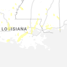
Mississippi
| Local Time | Report Details |
|---|---|
| 3:01 PM CDT | Awos station kbix biloxi keesle in harrison county MS, 54.8 miles WSW of Mobile, AL |
| 3:06 PM CDT | Power lines down near intersection of palmer creek dr and rashell d in harrison county MS, 62.5 miles W of Mobile, AL |
| 3:15 PM CDT | Power lines own near intersection of porter ave and judge sekul av in harrison county MS, 54.2 miles WSW of Mobile, AL |
| 3:15 PM CDT | Power lines down near hwy 49 and turkey cree in harrison county MS, 64.5 miles WSW of Mobile, AL |
| 3:16 PM CDT | Quarter sized hail reported near Gulfport, MS, 63.6 miles WSW of Mobile, AL, video relayed by broadcast media showing lots of pea sized hail... with a few bigger around a quarter size. |
| 3:23 PM CDT | A tree was blown onto highway 587 near racetrack roa in marion county MS, 73.7 miles SSE of Jackson, MS |
| 3:29 PM CDT | A tree was blown down and a roof was damaged on new hope church roa in marion county MS, 81.5 miles N of New Orleans, LA |
| 3:52 PM CDT | Multiple trees were blown down across highway 58 in marion county MS, 75.5 miles SSE of Jackson, MS |
Louisiana
| Local Time | Report Details |
|---|---|
| 3:21 PM CDT | 1-inch tree limbs broken; minor roof damage with some shingles blown of in washington county LA, 60.4 miles N of New Orleans, LA |
| 4:16 PM CDT | Broadcast media relayed pictures of trees down in the bedico are in tangipahoa county LA, 35 miles NNW of New Orleans, LA |
| 4:30 PM CDT | A tin roof was peeled off of a manufactured home and a tree was blown onto a hous in catahoula county LA, 79.5 miles N of Lafayette, LA |
| 5:18 PM CDT | Tree down in the town of salin in bienville county LA, 51.1 miles ESE of Shreveport, LA |
| 5:43 PM CDT | Quarter sized hail reported near Coushatta, LA, 34.6 miles SE of Shreveport, LA |
| 5:48 PM CDT | Tree down on trailer in hahnvill in st. charles county LA, 20 miles W of New Orleans, LA |
| 6:04 PM CDT | Tree down near germany and airlin in ascension county LA, 56.9 miles WNW of New Orleans, LA |
| 6:07 PM CDT | Ping Pong Ball sized hail reported near Oberlin, LA, 52.2 miles WNW of Lafayette, LA, reports of ping pong ball to golf ball sized hail from 911 center. |
| 6:24 PM CDT | Tree down on home on west main s in terrebonne county LA, 46.2 miles WSW of New Orleans, LA |
| 6:28 PM CDT | Tree down in powerlines on shady oaks ct in houm in terrebonne county LA, 46.7 miles WSW of New Orleans, LA |
| 6:28 PM CDT | Tree down near west park ave and hampto in terrebonne county LA, 46 miles WSW of New Orleans, LA |
| 6:36 PM CDT | Metal roof removed on venture blv in terrebonne county LA, 47.7 miles WSW of New Orleans, LA |
| 6:48 PM CDT | Power lines down on hwy 55 in bour in terrebonne county LA, 42.5 miles SW of New Orleans, LA |
| 7:38 PM CDT | Reports of trees down in leonvill in st. landry county LA, 17.3 miles N of Lafayette, LA |
| 7:47 PM CDT | Reports of trees down... damaged tin roofs... and of a fireplace stack that was knocked down in grand prairi in st. landry county LA, 32 miles NNW of Lafayette, LA |
| 8:04 PM CDT | Reports of property damage and power outage in st. landry county LA, 13.8 miles N of Lafayette, LA |
Tennessee
| Local Time | Report Details |
|---|---|
| 4:57 PM EDT | Quarter sized hail reported near Bristol, TN, 16.3 miles E of Bristol, TN, quarter size hail and a few trees down near shady valley. |
Florida
| Local Time | Report Details |
|---|---|
| 5:32 PM EDT | Duke energy reports power outages caused by fallen tree in jefferson county FL, 22.4 miles ENE of Tallahassee, FL |
| 7:27 PM EDT | Leon county dispatch reports a tree blocking all lanes of traffic on governors square blvd at blair stone r in leon county FL, 1.8 miles E of Tallahassee, FL |
| 7:27 PM EDT | Leon county dispatch reports a tree down on n gadsden st at beard s in leon county FL, 1.4 miles N of Tallahassee, FL |
| 7:27 PM EDT | Leon county dispatch reports a power line down and on fire in betton hill in leon county FL, 2.2 miles NNE of Tallahassee, FL |
| 7:27 PM EDT | Leon county dispatch reports a power line down on john knox rd at meridian r in leon county FL, 2.1 miles N of Tallahassee, FL |
| 7:27 PM EDT | Leon county dispatch reports a tree on a power line on spottswood d in leon county FL, 1.4 miles ENE of Tallahassee, FL |
| 7:27 PM EDT | Leon county dispatch reports a tree down on richview park circl in leon county FL, 3 miles E of Tallahassee, FL |
| 7:27 PM EDT | Leon county dispatch reports a tree fell on a power line on pennlyn d in leon county FL, 4.6 miles NE of Tallahassee, FL |
| 7:32 PM EDT | Midway fire department reports a tree fell on a car on dupont rd north of midwa in gadsden county FL, 11.5 miles WNW of Tallahassee, FL |
| 7:35 PM EDT | Leon county dispatch reports a tree fell on a power line on osceola st at main s in leon county FL, 1.5 miles SSW of Tallahassee, FL |
| 7:45 PM EDT | Leon county dispatch reports a power line down on windy pine wa in leon county FL, 3.6 miles SW of Tallahassee, FL |
| 8:12 PM EDT | Wakulla county dispatch reports a power line down on shadeville rd near andrew j hargrett sr r in wakulla county FL, 16.6 miles S of Tallahassee, FL |
| 8:12 PM EDT | Wakulla county dispatch reports a power line down on shadeville rd near gala c in wakulla county FL, 17.6 miles SSW of Tallahassee, FL |
| 8:12 PM EDT | Tree down on shadeville road in crawfordville florid in wakulla county FL, 15.3 miles S of Tallahassee, FL |
| 8:20 PM EDT | Wakulla county dispatch reports a tree down on jack crum rd at santa emma l in wakulla county FL, 23.9 miles SSW of Tallahassee, FL |
| 8:20 PM EDT | Wakulla county dispatch reports a tree down on spring creek hwy at i k porter r in wakulla county FL, 22.8 miles S of Tallahassee, FL |
| 8:30 PM EDT | 911 dispatch reports a tree on a hous in wakulla county FL, 23.6 miles S of Tallahassee, FL |
| 8:34 PM EDT | Apalachee bay panacea channel l8 mesonet site measured a 63 mph gus in gmz730 county FL, 29.8 miles S of Tallahassee, FL |
New Hampshire
| Local Time | Report Details |
|---|---|
| 5:35 PM EDT | Trees down on forest lane in pittsburg. time estimated by rada in coos county NH, 97.9 miles ENE of Burlington, VT |
| 5:35 PM EDT | Quarter sized hail reported near Pittsburg, NH, 97.9 miles ENE of Burlington, VT, hailstones 0.75 to 1.00 inch observed. |
| 5:35 PM EDT | Quarter sized hail reported near Pittsburg, NH, 94.1 miles ENE of Burlington, VT, social media photos of 1 inch hail in clarksville area on old canaan rd. hail lasted for 6-7 minutes. time estimated by radar. |
| 10:28 PM EDT | Half Dollar sized hail reported near Plainfield, NH, 75 miles SE of Burlington, VT, delayed report. |
| 10:30 PM EDT | Half Dollar sized hail reported near Claremont, NH, 84.9 miles SSE of Burlington, VT, delayed report. |
| 10:43 PM EDT | Delayed report. social media photos of trees down across haveril in grafton county NH, 64.7 miles ESE of Burlington, VT |
| 11:10 PM EDT | Delayed report. tree down on route 49 near dunkin donuts. also... 12 inch diameter tree damaged the roof of an equipment shed at a local schoo in grafton county NH, 70.5 miles WNW of Portland, ME |
Nebraska
| Local Time | Report Details |
|---|---|
| 4:15 PM MDT | Lots of small hail. winds estimated to be at least 60 mp in sheridan county NE, 89.9 miles W of Valentine, NE |
| 4:25 PM MDT | Multiple tree branches downed and trampoline destroyed. gusts estimated to be at least 60 mp in sheridan county NE, 80.7 miles W of Valentine, NE |
| 5:00 PM MDT | Driving rain and high winds... estimated around 60 mph. small hai in cherry county NE, 58.5 miles W of Valentine, NE |
| 7:50 PM CDT | Half Dollar sized hail reported near Bassett, NE, 46.3 miles W of Oneill, NE, quarter to half dollar sized... a lot of nickels. |
| 9:44 PM CDT | Nebraska mesonet statio in valley county NE, 57.5 miles NNW of Grand Island, NE |
Maine
| Local Time | Report Details |
|---|---|
| 7:30 PM EDT | Several trees reported down across river road in oakfiel in aroostook county ME, 53.6 miles S of Caribou, ME |
| 8:50 PM EDT | Trees and powerlines down on fahi pond rd. time estimated by rada in somerset county ME, 56.4 miles W of Bangor, ME |
| 8:50 PM EDT | Tree down across route 201a on the embden -north anson town line. time estimated by rada in somerset county ME, 53.9 miles W of Bangor, ME |
Connecticut
| Local Time | Report Details |
|---|---|
| 8:19 PM EDT | Large tree limbs (greater than 2 inches) down. 70 mph wind gust reporte in litchfield county CT, 63.3 miles SSE of Schenectady, NY |
Massachusetts
| Local Time | Report Details |
|---|---|
| 8:34 PM EDT | Tree down on wires near blue hill rd and stockbridge r in berkshire county MA, 51.4 miles SE of Schenectady, NY |
| 8:34 PM EDT | Tree down on wires near blue hill rd and stockbridge r in berkshire county MA, 51.4 miles SE of Schenectady, NY |
| 8:45 PM EDT | Tree and wires down on gulf r in berkshire county MA, 44.3 miles ESE of Schenectady, NY |
| 8:45 PM EDT | Multiple trees down in road near rt 41 and baker s in berkshire county MA, 42.5 miles SE of Schenectady, NY |
| 8:50 PM EDT | Tree down on house on benedict r in berkshire county MA, 43.6 miles ESE of Schenectady, NY |
| 8:50 PM EDT | Tree and wires down on stoddard av in berkshire county MA, 42.8 miles SE of Schenectady, NY |
| 8:50 PM EDT | Tree and phone pole down on berkshire av in berkshire county MA, 42.8 miles ESE of Schenectady, NY |
| 8:50 PM EDT | Tree and wires down on alcove s in berkshire county MA, 42.4 miles ESE of Schenectady, NY |
| 8:50 PM EDT | Tree down on house on lebanon moutain rd. time estimated from rada in berkshire county MA, 40.1 miles SE of Schenectady, NY |
| 8:51 PM EDT | Tree down on pecks r in berkshire county MA, 41.2 miles ESE of Schenectady, NY |
| 9:15 PM EDT | Corrects previous tstm wnd dmg report from 3 w worthington. tree down on powerlines near old north rd in worthington. relayed by amateur radi in hampshire county MA, 55.1 miles ESE of Schenectady, NY |
| 9:15 PM EDT | Corrects previous tstm wnd dmg report from 3 w worthington. tree down on powerlines near old north rd in worthington. relayed by amateur radi in hampshire county MA, 55.1 miles ESE of Schenectady, NY |
| 9:20 PM EDT | Tree down on county rd in huntington. relayed by amateur radi in hampshire county MA, 67.1 miles ESE of Schenectady, NY |
| 9:28 PM EDT | Tree down near dickinson hill rd in russell. relayed by amateur radi in hampden county MA, 69.1 miles SE of Schenectady, NY |
| 9:30 PM EDT | Tree and wires downed on pond road in rowe. relayed by amateur radi in franklin county MA, 54 miles E of Schenectady, NY |
| 9:30 PM EDT | Tree down blocking south river rd in charlemont. relayed by amateur radi in franklin county MA, 56.9 miles ESE of Schenectady, NY |
| 9:35 PM EDT | Tree down on west hawley rd in hawley. relayed by amateur radi in franklin county MA, 53.4 miles ESE of Schenectady, NY |
| 9:40 PM EDT | Tree down on wires on stillwater rd in deerfield. relayed by amateur radi in franklin county MA, 69.6 miles ESE of Schenectady, NY |
| 9:45 PM EDT | Tree down at intersection of meadow rd and south ferry rd in montague. relayed by amateur radi in franklin county MA, 73.1 miles ESE of Schenectady, NY |
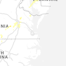
Delaware
| Local Time | Report Details |
|---|---|
| 9:16 PM EDT | The tops of some trees snapped off. time estimated from rada in kent county DE, 48.5 miles ESE of Baltimore, MD |
| 9:16 PM EDT | De state police reports trees down in the area of route 8 blocking the roadway in hartly. time estimated from rada in kent county DE, 50.4 miles ESE of Baltimore, MD |
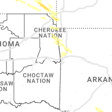
Kansas
| Local Time | Report Details |
|---|---|
| 2:57 AM CDT | Quarter sized hail reported near Independence, KS, 32.6 miles SSW of Chanute, KS |
| 5:15 AM CDT | Quarter sized hail reported near Parsons, KS, 25.8 miles SSE of Chanute, KS |
Missouri
| Local Time | Report Details |
|---|---|
| 4:30 AM CDT | Quarter sized hail reported near Seneca, MO, 76.5 miles SE of Chanute, KS |
| 4:31 AM CDT | Quarter sized hail reported near Goodman, MO, 75.4 miles WSW of Springfield, MO, report from mping: quarter (1.00 in.). |
Connect with Interactive Hail Maps