

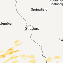
Hail Map for Saturday, April 23, 2011

Number of Impacted Households on 4/23/2011
0
Impacted by 1" or Larger Hail
0
Impacted by 1.75" or Larger Hail
0
Impacted by 2.5" or Larger Hail
Square Miles of Populated Area Impacted on 4/23/2011
0
Impacted by 1" or Larger Hail
0
Impacted by 1.75" or Larger Hail
0
Impacted by 2.5" or Larger Hail


Cities Most Affected by Hail Storms of 4/23/2011
| Hail Size | Demographics of Zip Codes Affected | ||||||
|---|---|---|---|---|---|---|---|
| City | Count | Average | Largest | Pop Density | House Value | Income | Age |
| Gainesville, TX | 6 | 2.42 | 3.00 | 74 | $70k | $35.5k | 38.3 |
| Comanche, TX | 2 | 2.25 | 2.75 | 16 | $45k | $29.4k | 43.0 |
| Sidney, TX | 2 | 2.25 | 2.75 | 8 | $51k | $38.2k | 49.2 |
| Tulsa, OK | 2 | 2.13 | 2.50 | 1210 | $75k | $38.7k | 37.8 |
| Anson, TX | 1 | 2.75 | 2.75 | 17 | $31k | $26.5k | 39.9 |
| Waurika, OK | 1 | 2.75 | 2.75 | 12 | $39k | $26.0k | 40.4 |
| Mountain Grove, MO | 1 | 2.50 | 2.50 | 33 | $65k | $23.5k | 41.2 |
| Eddyville, KY | 1 | 1.75 | 1.75 | 52 | $85k | $30.7k | 46.0 |
| Gorman, TX | 1 | 1.75 | 1.75 | 6 | $30k | $27.5k | 46.0 |
| Burkburnett, TX | 1 | 1.75 | 1.75 | 148 | $64k | $38.5k | 38.2 |
| Sapulpa, OK | 1 | 1.75 | 1.75 | 250 | $72k | $34.8k | 38.8 |
| Burneyville, OK | 1 | 1.75 | 1.75 | 13 | $83k | $36.7k | 48.1 |
| Isabella, MO | 1 | 1.75 | 1.75 | 21 | $97k | $28.2k | 53.6 |
| Forestburg, TX | 1 | 1.75 | 1.75 | 7 | $62k | $34.0k | 47.3 |
| Gordon, TX | 1 | 1.75 | 1.75 | 6 | $55k | $35.9k | 51.7 |
| Nocona, TX | 1 | 1.75 | 1.75 | 21 | $51k | $30.7k | 44.5 |
| Muenster, TX | 1 | 1.75 | 1.75 | 11 | $80k | $43.9k | 39.5 |
| May, TX | 1 | 1.75 | 1.75 | 13 | $38k | $32.2k | 52.7 |
| Saint Jo, TX | 1 | 1.75 | 1.75 | 5 | $46k | $30.5k | 43.1 |
Hail and Wind Damage Spotted on 4/23/2011
Filter by Report Type:Hail ReportsWind Reports
States Impacted
West Virginia, Indiana, Missouri, Kentucky, Illinois, Ohio, Texas, Oklahoma, ArkansasWest Virginia
| Local Time | Report Details |
|---|---|
| 12:35 PM UTC | Metal roof peeled on a shed in wirt county WV, 41.4 miles NNE of Charleston, WV |
| 10:09 PM UTC | Tree down blake road and 21st stree in kanawha county WV, 11.4 miles WNW of Charleston, WV |
| 10:15 PM UTC | Tree down on ballard road in kanawha county WV, 10.2 miles WSW of Charleston, WV |
| 10:15 PM UTC | Several trees down in downtown charleston in kanawha county WV, 0.5 miles E of Charleston, WV |
| 10:15 PM UTC | Tree down on coal river road in kanawha county WV, 12.1 miles W of Charleston, WV |
| 10:18 PM UTC | Tree down. river bend road and derricks creek road in kanawha county WV, 10.3 miles N of Charleston, WV |
| 10:18 PM UTC | Tree down on clearview heights road in kanawha county WV, 10.3 miles N of Charleston, WV |
| 10:18 PM UTC | Tree down on martins branch road in kanawha county WV, 10.3 miles N of Charleston, WV |
| 10:18 PM UTC | Tree down on teresa lanes in kanawha county WV, 10.3 miles N of Charleston, WV |
| 10:22 PM UTC | 2 trees down...one clipped house doing roof damag in kanawha county WV, 7 miles WSW of Charleston, WV |
| 11:06 PM UTC | Trees are down on state route 33 west near stumptown in gilmer county WV, 49.2 miles NE of Charleston, WV |
| 11:20 PM UTC | Signs were blown down along 1-79 between the flatwoods and burnsville exits in braxton county WV, 45.7 miles WSW of Elkins, WV |
| 11:32 PM UTC | Power lines are down...power line poles and telephone poles were snapped on bennett ave in webster springs in webster county WV, 43.3 miles SW of Elkins, WV |
| 11:32 PM UTC | Trees are down on point mountain road... hodem mountain road... and diana drive all in webster springs in webster county WV, 43.3 miles SW of Elkins, WV |
| 11:33 PM UTC | Trees are down on rock cave road and route 19 south near walkersville in lewis county WV, 33.4 miles W of Elkins, WV |
| 11:33 PM UTC | Trees are down on glady creek road in weston in lewis county WV, 34.6 miles WNW of Elkins, WV |
| 11:40 PM UTC | Trees down on frenchtown road in rock cave in upshur county WV, 27.3 miles WSW of Elkins, WV |
| 11:40 PM UTC | Trees down on gaines road in rock cave in upshur county WV, 27.3 miles WSW of Elkins, WV |
| 11:45 PM UTC | Trees are down on hoovertown road... abbott road and waterloo road in french creek in upshur county WV, 24.7 miles W of Elkins, WV |
| 11:47 PM UTC | A tree fell on a garage and snapped a power pole in half on brushy fork road off of rt 33 in buckhannon in upshur county WV, 21.3 miles WNW of Elkins, WV |
| 12:04 AM UTC | A metal pole fell on a car in the mcdonalds parking lot in downtown elkins in randolph county WV, 0.5 miles NW of Elkins, WV |
| 12:04 AM UTC | Numerous trees and powerlines are down throughout the city of elkins and surrounding areas in randolph county WV, 0.5 miles NW of Elkins, WV |
| 12:04 AM UTC | Numerous trees are down in the crystal springs area in randolph county WV, 1.4 miles NE of Elkins, WV |
| 12:33 AM UTC | Storm damage reported in grant county WV, 38.1 miles ENE of Elkins, WV |
Indiana
| Local Time | Report Details |
|---|---|
| 3:14 PM UTC | Quarter sized hail reported near Charlestown, IN, 32 miles N of Louisville, KY |
Missouri
| Local Time | Report Details |
|---|---|
| 7:01 PM UTC | Late report. older brick building under demolation had collapse in new madrid county MO, 49.3 miles S of Cape Girardeau, MO |
| 7:02 PM UTC | Late report. couple of sheds blown ove in new madrid county MO, 49.1 miles S of Cape Girardeau, MO |
| 7:30 PM UTC | Time estimated. late report. storage trailer had roof peeled off. 40 foot tree snapped. shingle damag in scott county MO, 21 miles S of Cape Girardeau, MO |
| 7:54 PM UTC | Quarter sized hail reported near Fordland, MO, 20.8 miles ESE of Springfield, MO |
| 7:56 PM UTC | Quarter sized hail reported near Seymour, MO, 30.2 miles E of Springfield, MO |
| 8:00 PM UTC | Half Dollar sized hail reported near Theodosia, MO, 56.2 miles SSE of Springfield, MO, delayed report cocorahs. |
| 8:08 PM UTC | Quarter sized hail reported near Mansfield, MO, 39.6 miles E of Springfield, MO, reorted quarter sized hail covering the gound. |
| 8:10 PM UTC | Ping Pong Ball sized hail reported near Mansfield, MO, 41 miles E of Springfield, MO, ping pong ball sized hail reported north of mansfield. reports of cars dented by hail. |
| 8:28 PM UTC | Quarter sized hail reported near Mountain Grove, MO, 48.7 miles SW of Salem, MO, volunteer observer. |
| 8:45 PM UTC | Quarter sized hail reported near Republic, MO, 12.4 miles WSW of Springfield, MO |
| 8:47 PM UTC | Golf Ball sized hail reported near Isabella, MO, 58 miles SE of Springfield, MO, hail covered the ground. |
| 8:51 PM UTC | Quarter sized hail reported near Theodosia, MO, 55 miles SE of Springfield, MO |
| 8:55 PM UTC | Ping Pong Ball sized hail reported near Raymondville, MO, 26.6 miles SW of Salem, MO |
| 9:08 PM UTC | Quarter sized hail reported near Springfield, MO, 6.5 miles ESE of Springfield, MO, reported at battlefield and u.s. 65 in springfield. |
| 9:18 PM UTC | Quarter sized hail reported near Halfway, MO, 19.4 miles N of Springfield, MO |
| 9:25 PM UTC | Ping Pong Ball sized hail reported near Mountain Grove, MO, 52.6 miles SW of Salem, MO |
| 9:28 PM UTC | Quarter sized hail reported near Seymour, MO, 22.2 miles E of Springfield, MO |
| 9:30 PM UTC | Tennis Ball sized hail reported near Mountain Grove, MO, 53 miles SW of Salem, MO |
| 9:40 PM UTC | Quarter sized hail reported near Dora, MO, 66.2 miles ESE of Springfield, MO |
| 9:40 PM UTC | Quarter sized hail reported near Fordland, MO, 19.7 miles E of Springfield, MO |
| 9:40 PM UTC | Quarter sized hail reported near Seymour, MO, 29.1 miles E of Springfield, MO |
| 9:40 PM UTC | Quarter sized hail reported near Jadwin, MO, 12.6 miles SSE of Salem, MO, relayed report. |
| 10:38 PM UTC | Quarter sized hail reported near Cuba, MO, 30.1 miles NNE of Salem, MO |
| 10:45 PM UTC | Ping Pong Ball sized hail reported near Bourbon, MO, 38.7 miles NNE of Salem, MO |
| 10:45 PM UTC | Ping Pong Ball sized hail reported near Leasburg, MO, 33.8 miles NNE of Salem, MO |
| 10:45 PM UTC | Ping Pong Ball sized hail reported near Leasburg, MO, 35.1 miles NNE of Salem, MO, spotter located in leesburg missouri |
| 12:28 AM UTC | Half Dollar sized hail reported near Mansfield, MO, 39.9 miles E of Springfield, MO |
| 12:29 AM UTC | Quarter sized hail reported near Mansfield, MO, 39.9 miles E of Springfield, MO |
| 4:31 AM UTC | Quarter sized hail reported near Portageville, MO, 61.7 miles S of Cape Girardeau, MO, hail fell on the southside in the town of portageville |
| 5:20 AM UTC | 2 mobile homes destroyed...another overturned. roof off of a shed and the windows blown out of a ban in butler county MO, 74 miles SW of Cape Girardeau, MO |
| 5:20 AM UTC | Power lines down and electricity out in the tow in butler county MO, 74 miles SW of Cape Girardeau, MO |
Kentucky
| Local Time | Report Details |
|---|---|
| 7:04 PM UTC | Roof damaged on a home on folsom-jonesville road. trees across the road and telephone poles blown ove in grant county KY, 29.9 miles SSW of Cincinnati, OH |
| 7:05 PM UTC | Barn roof blown off. trees and telephone poles downed on warsaw road/ky 467 in grant county KY, 29.9 miles SSW of Cincinnati, OH |
| 7:15 PM UTC | In visalia...2 homes with roofs blown off. visalia elementary school building damaged. trees downed/power lines with trees on the in kenton county KY, 12.4 miles S of Cincinnati, OH |
| 7:17 PM UTC | Trees across highway 1316. reports of roofs off of outbuilding in owen county KY, 38.3 miles SW of Cincinnati, OH |
| 7:20 PM UTC | Numerous trees down in the central part of the county. time estimate in pendleton county KY, 28.3 miles SSE of Cincinnati, OH |
| 7:20 PM UTC | 2 large cedar trees down. time estimated from rada in pendleton county KY, 22.2 miles S of Cincinnati, OH |
| 7:20 PM UTC | Home damaged/trees downed/power lines downed in kenton county KY, 12.4 miles S of Cincinnati, OH |
| 7:22 PM UTC | Barn blown over. time estimated from rada in pendleton county KY, 25.1 miles SSE of Cincinnati, OH |
| 7:40 PM UTC | Large branches down in town with unknown size hail. barn downed outside of tow in bracken county KY, 35.8 miles SE of Cincinnati, OH |
| 7:40 PM UTC | Barn blown down on augusta chatham rd east. one foot diameter trees blown down in dutch ridge road are in bracken county KY, 36.2 miles SE of Cincinnati, OH |
| 7:48 PM UTC | In the town of dover. three houses have trees downed on the in mason county KY, 40.8 miles SE of Cincinnati, OH |
| 7:50 PM UTC | Measured gust at barkley regional airpor in mccracken county KY, 47 miles ESE of Cape Girardeau, MO |
| 7:50 PM UTC | Late report. tree damage reported throughout the area. underpinning on several mobile homes damage in mccracken county KY, 47 miles ESE of Cape Girardeau, MO |
| 8:00 PM UTC | 4 telephone poles snapped along 16th stree in mccracken county KY, 52.4 miles ESE of Cape Girardeau, MO |
| 8:00 PM UTC | Downed and uprooted trees along with some power poles damaged near intersection of bruce and pecan driv in mccracken county KY, 52.4 miles ESE of Cape Girardeau, MO |
| 8:30 PM UTC | Large tree limbs were reported dow in lewis county KY, 71 miles NNE of Irvine, KY |
| 8:38 PM UTC | Golf Ball sized hail reported near Eddyville, KY, 68 miles SSW of Evansville, IN, golf ball size hail reported at the prison. |
| 9:07 PM UTC | Trees and power lines down in greenup county KY, 59.8 miles WNW of Charleston, WV |
| 9:16 PM UTC | Downed trees and power line in boyd county KY, 54.9 miles W of Charleston, WV |
| 9:16 PM UTC | Tree down on car at city par in boyd county KY, 54.9 miles W of Charleston, WV |
| 9:34 PM UTC | Quarter sized hail reported near Vine Grove, KY, 28 miles WSW of Louisville, KY, quarter sized hail covered roadways |
| 9:49 PM UTC | Quarter sized hail reported near Greenville, KY, 56.9 miles SSE of Evansville, IN, quarter size hail. |
| 9:50 PM UTC | Quarter sized hail reported near Centertown, KY, 46.7 miles SE of Evansville, IN |
| 9:55 PM UTC | Quarter sized hail reported near Beech Creek, KY, 61.5 miles SSE of Evansville, IN, nickel and quarter size hail reported. |
| 9:57 PM UTC | Weht relayed spotter report of estimated wind gusts between 60-70 mph in ohio county KY, 54.2 miles SE of Evansville, IN |
| 9:58 PM UTC | Quarter sized hail reported near Hardinsburg, KY, 42.6 miles WSW of Louisville, KY, ham relayed two reports of quarter sized hail |
| 10:21 PM UTC | Quarter sized hail reported near Boston, KY, 13.1 miles SSE of Louisville, KY, pea to quarter sized hail reported |
| 10:35 PM UTC | Quarter sized hail reported near Bardstown, KY, 17.3 miles SE of Louisville, KY, quarter sized hail reported |
| 12:45 AM UTC | Quarter sized hail reported near Olympia, KY, 31.4 miles NNE of Irvine, KY, firefighter reports quarter sized hail between 845 and 900 pm edt. |
Illinois
| Local Time | Report Details |
|---|---|
| 7:56 PM UTC | Widespread power outages in tow in massac county IL, 47.2 miles ESE of Cape Girardeau, MO |
| 7:57 PM UTC | Widespread trees and power pole damage on the north side of town near the honeywell plan in massac county IL, 47.2 miles ESE of Cape Girardeau, MO |
| 8:05 PM UTC | Downed and uprooted trees reported along north street. downed power poles. one tree is laying across a hous in massac county IL, 47.2 miles ESE of Cape Girardeau, MO |
Ohio
| Local Time | Report Details |
|---|---|
| 8:54 PM UTC | A half dozen trees were blown down with the saturated ground. time and location were estimate in scioto county OH, 67.4 miles WNW of Charleston, WV |
| 9:05 PM UTC | 10 foot by 40 foot porch flipped on roof of house. 18 inch diameter trees uprooted and broke of in lawrence county OH, 58.3 miles WNW of Charleston, WV |
| 9:05 PM UTC | Tree fell on power line then power line and transformer fell through roof of hous in lawrence county OH, 58.3 miles WNW of Charleston, WV |
| 9:10 PM UTC | Numerous trees and power lines down in lawrence county OH, 55.2 miles WNW of Charleston, WV |
| 9:12 PM UTC | Spotter witnessed 4 trees uprooted in lawrence county OH, 57.8 miles WNW of Charleston, WV |
| 9:15 PM UTC | Roofs reported off houses...and multiple trees down along ellisonville ridge road in upper township in lawrence county OH, 54.9 miles WNW of Charleston, WV |
| 9:20 PM UTC | Trees down along 141 near kitts in lawrence county OH, 53.2 miles WNW of Charleston, WV |
| 9:38 PM UTC | Metal roof rolled up allowing water damage to hous in lawrence county OH, 38 miles WNW of Charleston, WV |
Texas
| Local Time | Report Details |
|---|---|
| 9:43 PM UTC | Golf Ball sized hail reported near Forestburg, TX, 59.6 miles ESE of Wichita Falls, TX, forestburg vfd reported golfball hail 2 miles ne of forestburg |
| 9:45 PM UTC | Half Dollar sized hail reported near Forestburg, TX, 63.6 miles NW of Dallas, TX, half dollar hail in prairie point |
| 9:50 PM UTC | Baseball sized hail reported near Anson, TX, 17.3 miles NW of Abilene, TX, baseball size hail in truby |
| 10:06 PM UTC | Golf Ball sized hail reported near Muenster, TX, 66.3 miles ESE of Wichita Falls, TX, golfball hail 4 ssw of muenster |
| 10:16 PM UTC | Quarter sized hail reported near Muenster, TX, 66.6 miles NNW of Dallas, TX, quarter size hail 3 miles south of muenster |
| 10:24 PM UTC | Ping Pong Ball sized hail reported near Brownwood, TX, 66.2 miles SE of Abilene, TX |
| 10:31 PM UTC | Quarter sized hail reported near Lueders, TX, 25.2 miles NNE of Abilene, TX, quarter size hail reported in lueders. |
| 10:31 PM UTC | Half Dollar sized hail reported near Gainesville, TX, 62.3 miles NNW of Dallas, TX, half dollar hail 4 se of myra |
| 10:41 PM UTC | Quarter sized hail reported near Haskell, TX, 44.9 miles N of Abilene, TX |
| 5:54 PM CDT | Baseball sized hail reported near Gainesville, TX, 65.1 miles NNW of Dallas, TX, baseball hail in lindsay |
| 10:57 PM UTC | Quarter sized hail reported near Palo Pinto, TX, 79.3 miles S of Wichita Falls, TX, quarter hail reported on the west side of palo pinto |
| 10:58 PM UTC | Quarter sized hail reported near Gainesville, TX, 62.2 miles NNW of Dallas, TX, quarter size hail in gainesville |
| 6:02 PM CDT | Golf Ball sized hail reported near Gainesville, TX, 63.9 miles NNW of Dallas, TX, golfball hail 2 miles nw of gainesville |
| 6:03 PM CDT | Baseball sized hail reported near Gainesville, TX, 65.1 miles NNW of Dallas, TX, baseball hail in lindsay |
| 11:05 PM UTC | Tennis Ball sized hail reported near Gainesville, TX, 67.7 miles NNW of Dallas, TX, tennis ball hail reported 4 miles nne of lindsay |
| 11:06 PM UTC | Golf Ball sized hail reported near Gainesville, TX, 62.2 miles NNW of Dallas, TX, golfball size hail in gainesville |
| 11:18 PM UTC | Half Dollar sized hail reported near Sunset, TX, 52.6 miles SE of Wichita Falls, TX, half dollar size hail in sunset |
| 6:35 PM CDT | Tea Cup sized hail reported near Gainesville, TX, 64.1 miles NNW of Dallas, TX, orange size hail 2 north of gainesville |
| 11:45 PM UTC | Ping Pong Ball sized hail reported near Callisburg, TX, 64.8 miles NNW of Dallas, TX, ping pong ball size hail in callisburg |
| 11:49 PM UTC | Quarter sized hail reported near St Jo, TX, 56.9 miles ESE of Wichita Falls, TX, quarter size hail 2 southwest of st. jo |
| 12:00 AM UTC | Ping Pong Ball sized hail reported near Comanche, TX, 68 miles ESE of Abilene, TX, ping pong ball size hail 8 nw of decatur |
| 12:22 AM UTC | Golf Ball sized hail reported near St Jo, TX, 53.8 miles ESE of Wichita Falls, TX, golball size hail 4 miles west of st. jo |
| 12:24 AM UTC | Quarter sized hail reported near Comanche, TX, 62.4 miles ESE of Abilene, TX, 17w comanche |
| 12:25 AM UTC | Quarter sized hail reported near Strawn, TX, 70.3 miles E of Abilene, TX, quarter hail at ranger hill |
| 12:33 AM UTC | Golf Ball sized hail reported near Gordon, TX, 80.4 miles E of Abilene, TX, golfball size hail in gordon |
| 12:39 AM UTC | Ping Pong Ball sized hail reported near Nocona, TX, 45.2 miles E of Wichita Falls, TX, half dollar nocona hills |
| 12:40 AM UTC | Ping Pong Ball sized hail reported near Nocona, TX, 45.2 miles E of Wichita Falls, TX, ping pong ball size hail in nocona |
| 12:40 AM UTC | Golf Ball sized hail reported near Sidney, TX, 68.5 miles ESE of Abilene, TX |
| 12:43 AM UTC | Ping Pong Ball sized hail reported near Nocona, TX, 45.2 miles E of Wichita Falls, TX, golfball size hail in nocona |
| 12:43 AM UTC | Golf Ball sized hail reported near Nocona, TX, 47.1 miles E of Wichita Falls, TX, golfball size hail in nocona hills |
| 1:11 AM UTC | Chimney blown off a house on fm 1202...just west of outlet mall in cooke county TX, 66.6 miles NNW of Dallas, TX |
| 1:26 AM UTC | 67 mph wind gust reported by denton asos site kdto in denton county TX, 36.8 miles NW of Dallas, TX |
| 2:00 AM UTC | Golf Ball sized hail reported near Gorman, TX, 67.6 miles ESE of Abilene, TX, golfball size hail in duster |
| 2:03 AM UTC | Golf Ball sized hail reported near May, TX, 58 miles SE of Abilene, TX |
| 2:24 AM UTC | Half Dollar sized hail reported near Dublin, TX, 75.3 miles NNW of Killeen, TX |
| 2:25 AM UTC | Quarter sized hail reported near Dublin, TX, 75.3 miles NNW of Killeen, TX, quarter size hail in dublin |
| 2:50 AM UTC | Quarter sized hail reported near Mineral Wells, TX, 76 miles W of Dallas, TX, quarter hail in mineral wells |
| 2:55 AM UTC | Sherman asos (gyi) reports a 59 mph wind gust in grayson county TX, 58 miles SSW of Atoka, OK |
| 3:06 AM UTC | Baseball sized hail reported near Comanche, TX, 66.4 miles ESE of Abilene, TX, baseball size hail just west of beattie |
| 3:10 AM UTC | Baseball sized hail reported near Sidney, TX, 67.5 miles ESE of Abilene, TX, golfball to baseball size hail 1 mile west of sidney |
| 3:20 AM UTC | Golf Ball sized hail reported near Comanche, TX, 75.4 miles NW of Killeen, TX, golfball size hail in comanche |
| 10:40 PM CDT | Quarter sized hail reported near Electra, TX, 25.5 miles WNW of Wichita Falls, TX |
| 3:45 AM UTC | Quarter sized hail reported near Cashion Community, TX, 9.1 miles N of Wichita Falls, TX |
| 3:47 AM UTC | 68 mph wind gust reported at alliance airport asos (afw) in tarrant county TX, 34.9 miles WNW of Dallas, TX |
| 4:14 AM UTC | Numerous power lines and 3 inch tree limbs down in grapevine....colleyville and bedford in tarrant county TX, 21.8 miles WNW of Dallas, TX |
| 4:15 AM UTC | Quarter sized hail reported near Burkburnett, TX, 9.9 miles N of Wichita Falls, TX, quarter sized hail reported southeast of burkburnett near the intersection of 240 and bailey road. |
| 4:25 AM UTC | Golf Ball sized hail reported near Burkburnett, TX, 14 miles NNW of Wichita Falls, TX, delayed report of golfball sized hail near burkburnett. |
| 4:27 AM UTC | 58 mph wind gust at dfw airport in tarrant county TX, 19.6 miles WNW of Dallas, TX |
| 4:37 AM UTC | 60 mph wind gust in plano at the intersection of coit rd. and parker r in collin county TX, 17.2 miles NNE of Dallas, TX |
| 4:48 AM UTC | Addison asos reports 58 mph wind gust in dallas county TX, 11.9 miles N of Dallas, TX |
Oklahoma
| Local Time | Report Details |
|---|---|
| 10:36 PM UTC | Quarter sized hail reported near Marietta, OK, 65 miles WSW of Atoka, OK |
| 12:25 AM UTC | Golf Ball sized hail reported near Burneyville, OK, 70.2 miles E of Wichita Falls, TX, public report of quarter to golf ball sized hail in burneyville. |
| 12:56 AM UTC | Quarter sized hail reported near Leon, OK, 61.6 miles E of Wichita Falls, TX, delayed report of quarter sized hail in leon relayed by marietta police department. |
| 1:00 AM UTC | Quarter sized hail reported near Gene Autry, OK, 52.7 miles W of Atoka, OK |
| 1:20 AM UTC | Quarter sized hail reported near Mill Creek, OK, 39.6 miles W of Atoka, OK, quarter sized hail reported at mill creek fire department. |
| 2:42 AM UTC | Quarter sized hail reported near Muskogee, OK, 44.5 miles SE of Tulsa, OK |
| 3:02 AM UTC | Quarter sized hail reported near Dickson, OK, 52.3 miles WSW of Atoka, OK, quarter sized hail reported near dickson. |
| 3:03 AM UTC | Quarter sized hail reported near Oktaha, OK, 49 miles SE of Tulsa, OK, time estimated from radar |
| 10:30 PM CDT | Golf Ball sized hail reported near Sapulpa, OK, 12.2 miles SSW of Tulsa, OK |
| 10:37 PM CDT | Golf Ball sized hail reported near Sand Springs, OK, 5.1 miles WSW of Tulsa, OK |
| 10:40 PM CDT | Quarter sized hail reported near Tulsa, OK, 4.3 miles ESE of Tulsa, OK |
| 10:41 PM CDT | Quarter sized hail reported near Tulsa, OK, 4.3 miles ESE of Tulsa, OK, at kjrh studio. |
| 3:41 AM UTC | Quarter sized hail reported near Taft, OK, 36 miles SE of Tulsa, OK |
| 10:45 PM CDT | Ping Pong Ball sized hail reported near Tulsa, OK, 4.3 miles ESE of Tulsa, OK, location 4th and harvard and 21st and utica |
| 10:52 PM CDT | Tennis Ball sized hail reported near Tulsa, OK, 4.3 miles ESE of Tulsa, OK |
| 6:04 AM UTC | Golf Ball sized hail reported near , , 33.9 miles ENE of Wichita Falls, TX, quarter to golf ball sized hail reported in waurika. |
| 6:08 AM UTC | Half Dollar sized hail reported near , , 33.9 miles ENE of Wichita Falls, TX, public report of half dollar sized hail in north waurika. |
| 6:15 AM UTC | Baseball sized hail reported near Waurika, OK, 33.8 miles NE of Wichita Falls, TX, public report of baseball sized hail northwest of waurika. at least one home has taken minor damage from this hail. |
| 6:45 AM UTC | Half Dollar sized hail reported near Davis, OK, 57.2 miles W of Atoka, OK, quarter to half dollar sized hail reported by law enforcement in the city of davis. |
Arkansas
| Local Time | Report Details |
|---|---|
| 12:56 AM UTC | 16 inch diameter trees down... reported by knwa storm chase in madison county AR, 57.3 miles ENE of Fort Smith, AR |
| 1:49 AM UTC | Large trees were snapped. trees were down across county road 41 between mount judea and vendo in newton county AR, 84.3 miles ENE of Fort Smith, AR |
Connect with Interactive Hail Maps