

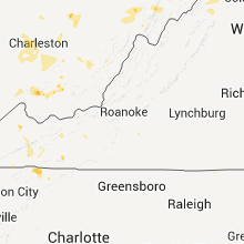
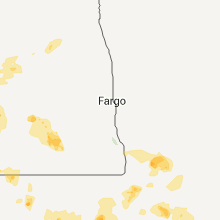
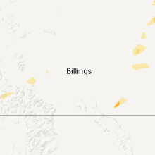
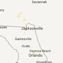
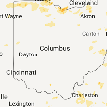
Hail Map for Friday, July 22, 2011

Number of Impacted Households on 7/22/2011
0
Impacted by 1" or Larger Hail
0
Impacted by 1.75" or Larger Hail
0
Impacted by 2.5" or Larger Hail
Square Miles of Populated Area Impacted on 7/22/2011
0
Impacted by 1" or Larger Hail
0
Impacted by 1.75" or Larger Hail
0
Impacted by 2.5" or Larger Hail


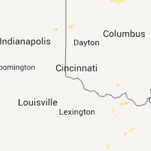


Cities Most Affected by Hail Storms of 7/22/2011
| Hail Size | Demographics of Zip Codes Affected | ||||||
|---|---|---|---|---|---|---|---|
| City | Count | Average | Largest | Pop Density | House Value | Income | Age |
| Buffalo, SD | 3 | 2.92 | 4.25 | 0 | $50k | $25.3k | 43.2 |
| Stockholm, ME | 2 | 1.75 | 1.75 | 8 | $71k | $30.8k | 52.8 |
| Ludlow, SD | 2 | 1.75 | 1.75 | 1 | $29k | $17.5k | 38.0 |
| Fort Peck, MT | 1 | 2.75 | 2.75 | 0 | $86k | $44.6k | 52.6 |
| Camp Crook, SD | 1 | 2.75 | 2.75 | 0 | $44k | $25.5k | 41.5 |
| Saint Francis, SD | 1 | 1.75 | 1.75 | 0 | $10k | $19.4k | 22.8 |
| Ekalaka, MT | 1 | 1.75 | 1.75 | 0 | $23k | $25.4k | 50.1 |
| Hettinger, ND | 1 | 1.75 | 1.75 | 2 | $42k | $29.8k | 49.3 |
| Parmelee, SD | 1 | 1.75 | 1.75 | 0 | $56k | $12.6k | 21.3 |
| Nashua, MT | 1 | 1.75 | 1.75 | 1 | $39k | $26.9k | 51.6 |
| Summit, SD | 1 | 1.75 | 1.75 | 3 | $24k | $26.8k | 37.1 |
Hail and Wind Damage Spotted on 7/22/2011
Filter by Report Type:Hail ReportsWind Reports
States Impacted
South Dakota, Illinois, Indiana, Ohio, Virginia, West Virginia, Maryland, Missouri, New Jersey, Florida, Montana, North Carolina, Pennsylvania, Texas, Kentucky, Tennessee, Nebraska, Kansas, Michigan, Iowa, Oklahoma, Maine, North Dakota, Colorado, Wyoming, Wisconsin, MinnesotaSouth Dakota
| Local Time | Report Details |
|---|---|
| 12:15 PM UTC | Quarter sized hail reported near , , 92 miles WNW of Sioux Falls, SD |
| 1:00 PM UTC | Quarter sized hail reported near Murdo, SD, 37.6 miles SSW of Pierre, SD, 1.65 inches rain |
| 10:40 PM UTC | Golf Ball sized hail reported near Summit, SD, 67.8 miles WNW of Montevideo, MN |
| 12:25 AM UTC | Golf Ball sized hail reported near Parmelee, SD, 33.7 miles NNW of Valentine, NE |
| 12:45 AM UTC | Quarter sized hail reported near St Francis, SD, 28.9 miles NNW of Valentine, NE |
| 12:45 AM UTC | Quarter sized hail reported near Strandburg, SD, 50.2 miles W of Montevideo, MN |
| 1:00 AM UTC | Quarter sized hail reported near Parmelee, SD, 32.8 miles NNW of Valentine, NE |
| 1:30 AM UTC | Half Dollar sized hail reported near St Francis, SD, 29.2 miles NNW of Valentine, NE |
| 1:31 AM UTC | Golf Ball sized hail reported near St Francis, SD, 28.9 miles NNW of Valentine, NE |
| 1:50 AM UTC | Storm damage reported in harding county SD, 102.6 miles ESE of Miles City, MT |
| 2:00 AM UTC | Funnel cloud observed in harding county SD, 106.1 miles ESE of Miles City, MT |
| 2:05 AM UTC | Storm damage reported in mellette county SD, 44.6 miles NNW of Valentine, NE |
| 2:15 AM UTC | Grapefruit sized hail reported near Buffalo, SD, 106.2 miles ESE of Miles City, MT |
| 2:17 AM UTC | Baseball sized hail reported near Camp Crook, SD, 103 miles ESE of Miles City, MT |
| 2:55 AM UTC | Quarter sized hail reported near Buffalo, SD, 114.9 miles N of Rapid City, SD |
| 3:00 AM UTC | Storm damage reported in harding county SD, 121.5 miles N of Rapid City, SD |
| 3:02 AM UTC | Storm damage reported in harding county SD, 110.2 miles N of Rapid City, SD |
| 3:10 AM UTC | Golf Ball sized hail reported near Ludlow, SD, 118.2 miles N of Rapid City, SD, hail lasted 15 minutes. |
| 3:20 AM UTC | Ping Pong Ball sized hail reported near Buffalo, SD, 114.1 miles N of Rapid City, SD |
| 3:25 AM UTC | Quarter sized hail reported near Ludlow, SD, 121.5 miles N of Rapid City, SD |
| 3:25 AM UTC | Golf Ball sized hail reported near Ludlow, SD, 118.2 miles N of Rapid City, SD |
| 3:40 AM UTC | Storm damage reported in perkins county SD, 89.1 miles SW of Bismarck, ND |
| 3:50 AM UTC | Quarter sized hail reported near Buffalo, SD, 101.7 miles ESE of Miles City, MT |
| 4:10 AM UTC | Golf Ball sized hail reported near Buffalo, SD, 106.1 miles ESE of Miles City, MT |
| 4:30 AM UTC | Quarter sized hail reported near Morristown, SD, 74.8 miles SW of Bismarck, ND, report also mentioned heavy rain and some strong winds...rainfall amount and wind speed unknown |
| 4:50 AM UTC | Baseball sized hail reported near Buffalo, SD, 115 miles N of Rapid City, SD |
| 5:06 AM UTC | Storm damage reported in corson county SD, 83.7 miles S of Bismarck, ND |
| 5:15 AM UTC | Golf Ball sized hail reported near Hettinger, SD, 118.9 miles N of Rapid City, SD |
| 5:17 AM UTC | Quarter sized hail reported near Buffalo, SD, 109.8 miles N of Rapid City, SD |
| 5:30 AM UTC | Storm damage reported in corson county SD, 77.2 miles SSE of Bismarck, ND |
| 5:40 AM UTC | Report also mentioned some small tree branches down at the rec area in walworth county SD, 79.5 miles N of Pierre, SD |
| 5:45 AM UTC | Storm damage reported in walworth county SD, 67.7 miles W of Aberdeen, SD |
| 5:45 AM UTC | Many trees down in city...10 to 12 inch diameter branches broke...power lines down from falling branches in mcpherson county SD, 58.9 miles WNW of Aberdeen, SD |
| 5:45 AM UTC | 50000 bushel grain bin destroyed...4 wheel grain cart tipped over in mcpherson county SD, 60.8 miles WNW of Aberdeen, SD |
| 6:00 AM UTC | A few uprooted trees...took the tops off of most of the trees in the shelter belt...tipped over a grain vac and feeder wagon...minor damage to house in mcpherson county SD, 54.8 miles NW of Aberdeen, SD |
| 6:00 AM UTC | Grain bin uprooted from fasteners and missing...north wall of garage pushed in....snapped corral poles...metal from pole barn wrapped around swather...8 to 10 in diamet in mcpherson county SD, 54.8 miles NW of Aberdeen, SD |
| 6:15 AM UTC | 8 - 10 in branches broke in walworth county SD, 64.3 miles W of Aberdeen, SD |
| 6:15 AM UTC | 4 in posts broke...minor shingle damage...loose tin on chicken coop in mcpherson county SD, 45 miles NW of Aberdeen, SD |
| 6:35 AM UTC | Quarter sized hail reported near Lodgepole, SD, 113.3 miles SW of Bismarck, ND |
| 7:00 AM UTC | 50 by 100 foot steel building had the 20 foot doors on the nothheast side pushed in and the south doors pushed out. metal shed 40 by 60 had doors blown in and metal rip in mcpherson county SD, 44.6 miles NW of Aberdeen, SD |
| 7:30 AM UTC | 60 to 70 mph wind gusts in brown county SD, 30.2 miles NNE of Aberdeen, SD |
Illinois
| Local Time | Report Details |
|---|---|
| 2:00 PM UTC | Power lines were reported down this morning on route 14 between woodstock and crystal lake. time and location of report are estimate in mchenry county IL, 47.6 miles NW of Chicago, IL |
Indiana
| Local Time | Report Details |
|---|---|
| 5:00 PM UTC | Numerous trees and branches reported down in angola. time estimated from rada in steuben county IN, 39.3 miles N of Fort Wayne, IN |
| 5:05 PM UTC | 40 plus trees down across county. approx 1000 acres of corn fields blown down. old barn blown down in steuben county IN, 38.6 miles N of Fort Wayne, IN |
| 5:10 PM UTC | Multiple trees uprooted and branches down on the north side of winimac. estimated wind gusts of 60-70 mp in pulaski county IN, 78.4 miles W of Fort Wayne, IN |
| 5:30 PM UTC | Tree down at juniper rd and sr 10 and tree on power line on sydney road in marshall county IN, 72.5 miles E of Chicago, IL |
| 5:36 PM UTC | *** 1 inj *** tree fell onto house at state road 10 and county road 600 in bass lak in starke county IN, 70.9 miles SE of Chicago, IL |
| 6:00 PM UTC | Trees down and power out in kosciusko county IN, 40.8 miles WNW of Fort Wayne, IN |
| 6:00 PM UTC | Tree down across fox farm road in kosciusko county IN, 42 miles WNW of Fort Wayne, IN |
| 6:05 PM UTC | Power lines down on center and main st in kosciusko county IN, 40.8 miles WNW of Fort Wayne, IN |
| 6:08 PM UTC | Storm damage reported in kosciusko county IN, 37 miles WNW of Fort Wayne, IN |
| 6:15 PM UTC | Small to medium branches falling as wel in whitley county IN, 27.7 miles W of Fort Wayne, IN |
| 6:15 PM UTC | Power line down across sr 105 south of south whitley. time estimated from rada in whitley county IN, 27.7 miles W of Fort Wayne, IN |
| 6:27 PM UTC | Estimated 60 mph gust associated with outflow in whitley county IN, 20.5 miles W of Fort Wayne, IN |
| 6:30 PM UTC | Trees and power lines down in dekalb county IN, 20.4 miles N of Fort Wayne, IN |
| 6:30 PM UTC | Tree across road on sr 105 just north of us 24. time estimated from radar in huntington county IN, 30.7 miles WSW of Fort Wayne, IN |
| 6:39 PM UTC | Power lines down at garden st and washington blvd from outflow boundary in allen county IN, 3.2 miles W of Fort Wayne, IN |
| 6:45 PM UTC | Trees and power lines down in northern portion of allen county in allen county IN, 11.5 miles NE of Fort Wayne, IN |
| 3:45 AM UTC | Power line down on sr 10 and juniper road in marshall county IN, 60.6 miles W of Fort Wayne, IN |
| 4:25 AM UTC | Large limb down on s 600 e and e van ness rd. time estimated from radar in kosciusko county IN, 33.7 miles WNW of Fort Wayne, IN |
Ohio
| Local Time | Report Details |
|---|---|
| 5:18 PM UTC | Also large limbs down and 1.33 inches of rain in 20 minutes in henry county OH, 54.2 miles ENE of Fort Wayne, IN |
| 5:45 PM UTC | Numerous trees down in city of orego in lucas county OH, 90.3 miles W of Cleveland, OH |
| 6:10 PM UTC | One 8 inch diameter tree down and a 6 inch diameter limb down just east of mccutchenivlle in seneca count in seneca county OH, 72.7 miles N of Columbus, OH |
| 6:14 PM UTC | Storm damage reported in lucas county OH, 88.7 miles ENE of Fort Wayne, IN |
| 6:15 PM UTC | Numerous trees down across lucas count in lucas county OH, 88.7 miles ENE of Fort Wayne, IN |
| 6:20 PM UTC | Several 15 inch diameter trees dow in lucas county OH, 82.7 miles ENE of Fort Wayne, IN |
| 6:30 PM UTC | Trees...power poles...and power lines down in archbold and sw part of county in fulton county OH, 51.3 miles NE of Fort Wayne, IN |
| 6:30 PM UTC | Tree limbs down on power line in ottawa county OH, 83 miles W of Cleveland, OH |
| 6:30 PM UTC | 8 inch diameter limb down smashed a fenc in lucas county OH, 88.7 miles ENE of Fort Wayne, IN |
| 6:30 PM UTC | Multiple limbs down on power line in lucas county OH, 88.7 miles ENE of Fort Wayne, IN |
| 6:35 PM UTC | Several trees dow in wayne county OH, 37.2 miles S of Cleveland, OH |
| 6:35 PM UTC | Several downed tree in wayne county OH, 37.5 miles S of Cleveland, OH |
| 6:39 PM UTC | Tree into a hous in sandusky county OH, 61.7 miles WSW of Cleveland, OH |
| 6:48 PM UTC | Multiple limbs down and power lines dow in ottawa county OH, 75.7 miles W of Cleveland, OH |
| 6:53 PM UTC | Large tree branch blocking sr 73 in clinton county OH, 41.9 miles NE of Cincinnati, OH |
| 7:00 PM UTC | Tree 18-22 inch diameter dow in lucas county OH, 88.7 miles ENE of Fort Wayne, IN |
| 7:02 PM UTC | Multiple limbs down on power line in lucas county OH, 88.7 miles ENE of Fort Wayne, IN |
| 7:10 PM UTC | Tree limbs down on power line in ottawa county OH, 83 miles W of Cleveland, OH |
| 7:10 PM UTC | Multiple limbs down and power lines dow in ottawa county OH, 75.7 miles W of Cleveland, OH |
| 7:13 PM UTC | Power lines down on cr 71. time estimated from radar in paulding county OH, 22.5 miles E of Fort Wayne, IN |
| 7:15 PM UTC | Trees down in indian creek developmen in cuyahoga county OH, 11.2 miles SSW of Cleveland, OH |
| 7:15 PM UTC | 8 inch diameter limb down smashed a fenc in lucas county OH, 88.7 miles ENE of Fort Wayne, IN |
| 7:15 PM UTC | Multiple trees dow in erie county OH, 53.6 miles W of Cleveland, OH |
| 7:30 PM UTC | Tree into a hous in sandusky county OH, 61.7 miles WSW of Cleveland, OH |
| 7:30 PM UTC | Numerous trees down throughout cuyahoga count in cuyahoga county OH, 1.8 miles SSE of Cleveland, OH |
| 7:30 PM UTC | Trees down in fulton county OH, 55 miles NE of Fort Wayne, IN |
| 7:57 PM UTC | Trees down in the national park in brecksvill in cuyahoga county OH, 13.9 miles SSE of Cleveland, OH |
| 7:57 PM UTC | Tent and temporary wall blown down at county fair in putnam county OH, 54.9 miles E of Fort Wayne, IN |
| 8:00 PM UTC | Downed trees and wires in city of lorai in lorain county OH, 25.8 miles W of Cleveland, OH |
| 8:04 PM UTC | Blowing dust reduced visibility to near zero at times. traffic stopped on interstate 75. time estimated from radar in allen county OH, 59.3 miles ESE of Fort Wayne, IN |
| 8:07 PM UTC | Measured 60 kt gust at kaoh asos in allen county OH, 61.4 miles ESE of Fort Wayne, IN |
| 8:20 PM UTC | Pole barn destroyed on sr 67 just west of uniopoli in auglaize county OH, 61.8 miles ESE of Fort Wayne, IN |
| 8:22 PM UTC | Steel roof ripped off outbuilding in auglaize county OH, 52.4 miles SE of Fort Wayne, IN |
| 8:29 PM UTC | Large tree down on house and car in columbiana county OH, 51.9 miles WNW of Pittsburgh, PA |
| 8:30 PM UTC | Trees down in the national park in brecksvill in cuyahoga county OH, 13.9 miles SSE of Cleveland, OH |
| 8:30 PM UTC | Numerous trees and wires down throughout lake count in lake county OH, 19.3 miles ENE of Cleveland, OH |
| 8:30 PM UTC | Trees down in indian creek developmen in cuyahoga county OH, 11.2 miles SSW of Cleveland, OH |
| 8:35 PM UTC | Large trees blown down on sr 171 in carroll county OH, 62 miles WNW of Pittsburgh, PA |
| 8:50 PM UTC | Multiple trees down on sr 9 in columbiana county OH, 46.6 miles WNW of Pittsburgh, PA |
| 8:50 PM UTC | Multiple trees down on sr 9 in columbiana county OH, 42.1 miles WNW of Pittsburgh, PA |
| 9:00 PM UTC | Numerous trees down mainly northern portion of the count in trumbull county OH, 48.8 miles ESE of Cleveland, OH |
| 9:05 PM UTC | *** 1 fatal *** 2 large trees fell along with wires on a vehicle killing the driver. this occurred on the 5000 block of sodum hutchings road in johnston townshi in trumbull county OH, 54.2 miles E of Cleveland, OH |
| 9:11 PM UTC | Some limbs down in town and a tree down near the road 2 miles north of marshalvill in wayne county OH, 41.8 miles S of Cleveland, OH |
| 9:11 PM UTC | Roof off of a church on the south side of tow in mahoning county OH, 53.8 miles NW of Pittsburgh, PA |
| 10:14 PM UTC | Tree down across lake view dr in genoa tw in delaware county OH, 17.5 miles NNE of Columbus, OH |
| 10:40 PM UTC | Large tree down in belmont county OH, 53.7 miles WSW of Pittsburgh, PA |
| 11:08 PM UTC | Lots of trees down in belmont county OH, 57.6 miles SW of Pittsburgh, PA |
| 11:11 PM UTC | Several trees down along old sr 73. time estimated from radar in scioto county OH, 71.1 miles E of Cincinnati, OH |
Virginia
| Local Time | Report Details |
|---|---|
| 5:30 PM UTC | One pine tree and several large limbs down between ceres and blan in bland county VA, 64.1 miles ENE of Bristol, TN |
| 5:35 PM UTC | Tree blown down on south scenic highwa in bland county VA, 66.8 miles ENE of Bristol, TN |
| 7:15 PM UTC | Trees down about 3 miles south of glade springs in washington county VA, 27.3 miles ENE of Bristol, TN |
| 7:38 PM UTC | Several trees down on miller lane. 5 homes with minor damag in pulaski county VA, 49.8 miles WSW of Roanoke, VA |
| 7:38 PM UTC | Trees down on bus at memorial dive and bob white blvd in pulaski county VA, 47.2 miles WSW of Roanoke, VA |
| 7:38 PM UTC | Quarter sized hail reported near Pulaski, VA, 49.8 miles WSW of Roanoke, VA, quarter inch hail reported on miller road. |
| 7:40 PM UTC | Trees and branches dow in pulaski county VA, 49.5 miles WSW of Roanoke, VA |
| 7:45 PM UTC | Multiple large limbs blown down along route 11 near the intersection with route 10 in pulaski county VA, 43 miles WSW of Roanoke, VA |
| 7:45 PM UTC | 8 inch diameter tree down on woodlyn st in pulaski county VA, 43.2 miles WSW of Roanoke, VA |
| 7:45 PM UTC | Large limbs down on route 1 in pulaski county VA, 45.7 miles WSW of Roanoke, VA |
| 8:00 PM UTC | 4 dozen trees destroyed. roof torn off rock harbor golf course pavilion. 1 injured in city of winchester county VA, 85.2 miles W of Baltimore, MD |
| 8:00 PM UTC | Trees down west of wincheste in frederick county VA, 87.3 miles W of Baltimore, MD |
| 8:05 PM UTC | Several trees down near glade spring in washington county VA, 28.5 miles ENE of Bristol, TN |
| 8:05 PM UTC | Trees down on merrimans lane and amherst street in city of winchester county VA, 85.2 miles W of Baltimore, MD |
| 8:22 PM UTC | Several trees down on allen roa in clarke county VA, 73.7 miles W of Baltimore, MD |
| 8:22 PM UTC | Tree down on crums church roa in clarke county VA, 75.3 miles W of Baltimore, MD |
| 8:22 PM UTC | Tree onto house on 11000 block of harry byrd highwa in clarke county VA, 76.6 miles W of Baltimore, MD |
| 8:23 PM UTC | Several trees were down to the north and west of berryvill in clarke county VA, 77 miles W of Baltimore, MD |
| 8:29 PM UTC | Large limb down on roadway on lord fairfax highway near greenway avenu in clarke county VA, 77.4 miles W of Baltimore, MD |
| 8:35 PM UTC | Few trees down by dispatc in russell county VA, 32.4 miles NNE of Bristol, TN |
| 8:43 PM UTC | 3-6 inch branches down in fairfax county VA, 40.8 miles SW of Baltimore, MD |
| 8:47 PM UTC | Tree blocking intersection of main street and old chapel avenu in clarke county VA, 79.1 miles W of Baltimore, MD |
| 8:47 PM UTC | Tree down on powerlines at intersection of main and crescent street in clarke county VA, 79.1 miles W of Baltimore, MD |
| 9:00 PM UTC | Several trees blown down in the forest north of river ridge drive in warren county VA, 87 miles E of Elkins, WV |
| 9:20 PM UTC | Trees uprooted and large limbs snapped in the bennett run road and overly hollow area in rockingham county VA, 45.9 miles ESE of Elkins, WV |
| 11:05 PM UTC | Many trees down on bluewater drive near scruggs. couple trees on houses with power lines also toppled at one residence. quarter size hail also observed. event took plac in franklin county VA, 20.3 miles SE of Roanoke, VA |
| 12:25 AM UTC | Trees down at camp along stokesville road. time estimate in augusta county VA, 53.6 miles SE of Elkins, WV |
West Virginia
| Local Time | Report Details |
|---|---|
| 5:56 PM UTC | 6-7 trees down one to two feet in diameter in morgan county WV, 83.9 miles SSW of State College, PA |
| 5:56 PM UTC | Several large trees down and numerous large branches down for a two mile stretch of river road in vicinity of river road and culp roa in morgan county WV, 77.6 miles S of State College, PA |
| 6:12 PM UTC | Trees down on huffman road near route 22 in hampshire county WV, 53 miles ENE of Elkins, WV |
| 6:16 PM UTC | A tree was down in levels near intersection of little cacapon and levels road in hampshire county WV, 79.4 miles ENE of Elkins, WV |
| 6:16 PM UTC | A tree was down in level in hampshire county WV, 78.9 miles ENE of Elkins, WV |
| 6:20 PM UTC | Trees down near campbell road and springfield pik in hampshire county WV, 74.5 miles ENE of Elkins, WV |
| 6:33 PM UTC | 6-7 trees down one to two feet in diameter in morgan county WV, 83.9 miles SSW of State College, PA |
| 6:51 PM UTC | Trees down on st andrews dr. near williamsport pike and bedington r in berkeley county WV, 72 miles WNW of Baltimore, MD |
| 7:05 PM UTC | Several branches 6 to 8 inches in diameter down. a large tree knocked down onto power lines. all near intersection of st. andrews dr. and spring mills r in berkeley county WV, 72.4 miles WNW of Baltimore, MD |
| 7:05 PM UTC | Tree branches down near grade road and vineyard road in berkeley county WV, 73.6 miles WNW of Baltimore, MD |
| 7:13 PM UTC | Tree onto powerlines near intersection of williamsport pike and railroad drive in berkeley county WV, 72.3 miles WNW of Baltimore, MD |
| 8:50 PM UTC | Storm damage reported in grant county WV, 38.1 miles ENE of Elkins, WV |
| 9:00 PM UTC | A few trees knocked down across roadway near intersection of corners road and north fork highwa in grant county WV, 35.1 miles E of Elkins, WV |
| 9:24 PM UTC | Two trees across durgan road as well as several branches on powerline in hardy county WV, 43 miles E of Elkins, WV |
| 10:10 PM UTC | Several large trees dow in gilmer county WV, 52.6 miles W of Elkins, WV |
| 10:10 PM UTC | Several trees down on rte 1 and rte 3 in the ravencliff area...doh called out to clear them...power outages reported in the area in wyoming county WV, 46.3 miles S of Charleston, WV |
| 10:20 PM UTC | Trees down on rte 10 just outside of man in logan county WV, 43.1 miles SSW of Charleston, WV |
| 11:10 PM UTC | Large branches broken. winds in area around 40 mp in kanawha county WV, 5.5 miles NNE of Charleston, WV |
Maryland
| Local Time | Report Details |
|---|---|
| 6:16 PM UTC | Trees down along mercersburg roa in washington county MD, 75 miles WNW of Baltimore, MD |
| 6:38 PM UTC | Trees down near intersection of boyd road and big pool roa in washington county MD, 76.4 miles WNW of Baltimore, MD |
| 6:45 PM UTC | Trees and road signs down near hickory school road and virginia avenu in washington county MD, 66.6 miles WNW of Baltimore, MD |
| 6:48 PM UTC | Stadium lights tower blown over into hagerstown suns stadiu in washington county MD, 64.3 miles WNW of Baltimore, MD |
| 6:48 PM UTC | Tree down on george stree in washington county MD, 64.8 miles WNW of Baltimore, MD |
| 6:48 PM UTC | Tree down on rench roa in washington county MD, 65.4 miles WNW of Baltimore, MD |
| 6:48 PM UTC | Numerous trees down on cathedral avenu in washington county MD, 63.9 miles WNW of Baltimore, MD |
| 6:51 PM UTC | Numerous trees down across the count in washington county MD, 69.9 miles WNW of Baltimore, MD |
| 6:51 PM UTC | Large branches and one tree down on dual highway rt 40 and eastern boulevard in washington county MD, 64.3 miles WNW of Baltimore, MD |
| 7:00 PM UTC | Tree down on national pike at beaver creek roa in washington county MD, 64.1 miles WNW of Baltimore, MD |
| 7:04 PM UTC | Tree down on cool hallow roa in washington county MD, 59.9 miles WNW of Baltimore, MD |
| 7:26 PM UTC | A couple of trees were down along route 17 near meetinghouse roa in frederick county MD, 52.2 miles WNW of Baltimore, MD |
Missouri
| Local Time | Report Details |
|---|---|
| 6:35 PM UTC | Damaging downburst wind gusts destroyed two machine sheds that were 25 ft wide and 60 ft in length. two corn cribs were also destroyed along with several downed large t in texas county MO, 27.2 miles SW of Salem, MO |
| 7:00 PM UTC | Damaging downburst wind gusts destroyed two machine sheds that were 25 ft wide and 60 ft in length. two corn cribs were also destroyed along with several downed large t in texas county MO, 27.2 miles SW of Salem, MO |
| 9:30 PM UTC | Severe thunderstorm wind gusts downed some large tree limbs at vickis feathered friends farm southeast of boliva in polk county MO, 24.4 miles N of Springfield, MO |
| 9:39 PM UTC | Severe thunderstorm wind gusts downed a few tree limb in maries county MO, 39 miles NNW of Salem, MO |
| 10:34 PM UTC | Quarter sized hail reported near Latham, MO, 33.1 miles SSW of Columbia, MO |
New Jersey
| Local Time | Report Details |
|---|---|
| 6:41 PM UTC | Runway anemometer at afb from afb forecaster in burlington county NJ, 54.7 miles SW of Brooklyn, NY |
| 7:10 PM UTC | Numerous trees down in burlington county NJ, 58.8 miles SSW of Brooklyn, NY |
| 10:02 PM UTC | Runway anemometer at afb from afb forecaster in burlington county NJ, 54.7 miles SW of Brooklyn, NY |
Florida
| Local Time | Report Details |
|---|---|
| 6:52 PM UTC | The asos at the regional southwest international airport measured a wind gust of 52 knots or 60 mp in lee county FL, 27.7 miles N of Naples, FL |
| 6:58 PM UTC | The asos at page field measured a wind gust of 50 knots or 58 mp in lee county FL, 30.7 miles N of Naples, FL |
| 7:49 PM UTC | The asos at charlotte county airport measured a wind gust of 51 knots or 59 mp in charlotte county FL, 54.1 miles SE of Bradenton, FL |
| 9:30 PM UTC | Central dispatch reported a wire down off of loretto road in the mandarin are in duval county FL, 12.1 miles SSE of Jacksonville, FL |
| 9:30 PM UTC | Central dispatch reported a wire down off of loretto road in the mandarin are in duval county FL, 11.9 miles S of Jacksonville, FL |
Montana
| Local Time | Report Details |
|---|---|
| 7:03 PM UTC | Quarter sized hail reported near Malta, MT, 44.4 miles WSW of Glasgow, MT |
| 7:03 PM UTC | Half Dollar sized hail reported near Malta, MT, 58 miles WNW of Glasgow, MT |
| 7:03 PM UTC | Ping Pong Ball sized hail reported near Malta, MT, 58 miles WNW of Glasgow, MT |
| 8:42 PM UTC | Half Dollar sized hail reported near Glasgow, MT, 0.4 miles NNW of Glasgow, MT, mainly dime and quarter size hail with some half dollar size. |
| 8:43 PM UTC | Quarter sized hail reported near Fort Peck, MT, 5 miles SSE of Glasgow, MT |
| 8:46 PM UTC | Quarter sized hail reported near Glasgow, MT, 0.4 miles NNW of Glasgow, MT |
| 8:59 PM UTC | Baseball sized hail reported near Fort Peck, MT, 13.1 miles SSE of Glasgow, MT |
| 9:04 PM UTC | Half Dollar sized hail reported near Nashua, MT, 13.6 miles ESE of Glasgow, MT |
| 9:05 PM UTC | Half Dollar sized hail reported near Glasgow, MT, 8.4 miles ESE of Glasgow, MT |
| 9:30 PM UTC | Roof damaged by high wind in valley county MT, 25.2 miles S of Glasgow, MT |
| 9:45 PM UTC | Quarter sized hail reported near Frazer, MT, 34 miles E of Glasgow, MT |
| 9:46 PM UTC | Quarter sized hail reported near Frazer, MT, 29.1 miles ESE of Glasgow, MT |
| 9:46 PM UTC | Quarter sized hail reported near Frazer, MT, 32.9 miles E of Glasgow, MT |
| 9:46 PM UTC | Storm damage reported in mccone county MT, 50.8 miles N of Miles City, MT |
| 10:00 PM UTC | Golf Ball sized hail reported near Nashua, MT, 20.7 miles ESE of Glasgow, MT, hail still on the ground 4 hours afer the event. crops damaged by hail. |
| 10:15 PM UTC | Storm damage reported in mccone county MT, 47.7 miles ESE of Glasgow, MT |
| 10:20 PM UTC | Half Dollar sized hail reported near Terry, MT, 46.6 miles N of Miles City, MT |
| 11:00 PM UTC | Also measured 1.78 inches of rain in dawson county MT, 66.7 miles ESE of Glasgow, MT |
| 11:11 PM UTC | Storm damage reported in prairie county MT, 42 miles NNE of Miles City, MT |
| 11:12 PM UTC | Storm damage reported in dawson county MT, 72.7 miles NE of Miles City, MT |
| 11:12 PM UTC | Storm damage reported in dawson county MT, 80.5 miles SW of Williston, ND |
| 11:12 PM UTC | Possible brief tornado toughdown. relayed by prairie county dispatc in prairie county MT, 36.4 miles NE of Miles City, MT |
| 11:45 PM UTC | Storm damage reported in custer county MT, 39 miles E of Miles City, MT |
| 11:45 PM UTC | Quarter sized hail reported near Ismay, MT, 37.9 miles E of Miles City, MT |
| 11:55 PM UTC | Storm damage reported in dawson county MT, 72.7 miles NE of Miles City, MT |
| 12:26 AM UTC | Storm damage reported in wibaux county MT, 84.2 miles SSW of Williston, ND |
| 12:30 AM UTC | Trees knocked ove in wibaux county MT, 84.2 miles SSW of Williston, ND |
| 12:57 AM UTC | Golf Ball sized hail reported near Ekalaka, MT, 71.8 miles ESE of Miles City, MT |
| 1:00 AM UTC | Quarter sized hail reported near Ekalaka, MT, 72.3 miles ESE of Miles City, MT |
| 1:00 AM UTC | Ping Pong Ball sized hail reported near Ekalaka, MT, 71.8 miles ESE of Miles City, MT |
| 1:20 AM UTC | Half Dollar sized hail reported near Ekalaka, MT, 78.2 miles ESE of Miles City, MT |
| 1:30 AM UTC | Half Dollar sized hail reported near Baker, MT, 88.2 miles ESE of Miles City, MT |
North Carolina
| Local Time | Report Details |
|---|---|
| 8:00 PM UTC | Tree and multiple limbs down near intersection of grain bin lane foy lockamy road. time estimated from rada in onslow county NC, 42.5 miles NE of Wilmington, NC |
| 10:47 PM UTC | Homeowner at 124 dobbins street called to report two large oak trees uprooted causing damage to property fences as well as the house in richmond county NC, 68.7 miles ESE of Charlotte, NC |
Pennsylvania
| Local Time | Report Details |
|---|---|
| 4:07 PM EDT | Trees and wires reported down in paradise tw in york county PA, 44.5 miles NNW of Baltimore, MD |
| 4:22 PM EDT | Trees down on wires at south lake rd and old hanover r in york county PA, 42.8 miles NNW of Baltimore, MD |
| 4:42 PM EDT | Trees down at east prospect rd and frysville rd in windsor tw in york county PA, 46.2 miles N of Baltimore, MD |
| 9:15 PM UTC | Large trees and power lines blown dow in mercer county PA, 58.1 miles NNW of Pittsburgh, PA |
| 9:18 PM UTC | Large trees and power lines blown dow in beaver county PA, 27.4 miles NW of Pittsburgh, PA |
| 9:29 PM UTC | Multiple trees and wires down in mercer county PA, 68.3 miles E of Cleveland, OH |
| 9:30 PM UTC | Large trees and power lines blown dow in mercer county PA, 56.1 miles NNW of Pittsburgh, PA |
| 9:30 PM UTC | Several festival tents blown ove in allegheny county PA, 17.7 miles NE of Pittsburgh, PA |
| 9:35 PM UTC | Large branches down in lawrence county PA, 32.7 miles NNW of Pittsburgh, PA |
| 9:35 PM UTC | Numerous large trees and power lines blown down onto sr 208 and ligo lan in lawrence county PA, 50.2 miles NNW of Pittsburgh, PA |
| 9:35 PM UTC | Large trees blown dow in butler county PA, 24.6 miles NE of Pittsburgh, PA |
| 9:40 PM UTC | Multiple trees down in armstrong county PA, 22.7 miles NE of Pittsburgh, PA |
| 10:00 PM UTC | Tree down on i-80 in venango county PA, 50.5 miles N of Pittsburgh, PA |
| 10:05 PM UTC | Large trees and power lines blown down onto furnace run and iron bridge road in armstrong county PA, 27.7 miles NE of Pittsburgh, PA |
| 10:12 PM UTC | Few trees down in armstrong county PA, 31.2 miles NE of Pittsburgh, PA |
| 10:15 PM UTC | Large trees and power lines blown dow in mercer county PA, 50 miles N of Pittsburgh, PA |
| 10:30 PM UTC | Numerous trees down in butler county PA, 31.7 miles NNE of Pittsburgh, PA |
| 10:35 PM UTC | Trees down on road in allegheny county PA, 9.7 miles ENE of Pittsburgh, PA |
| 11:20 PM UTC | Multiple trees down on driftwood road in washington county PA, 29 miles S of Pittsburgh, PA |
| 11:20 PM UTC | Multiple trees down on driftwood road in fayette county PA, 29.8 miles S of Pittsburgh, PA |
| 12:00 AM UTC | Trees down in fayette county PA, 27.5 miles SSE of Pittsburgh, PA |
Texas
| Local Time | Report Details |
|---|---|
| 8:10 PM UTC | Porch roof blown off mobile home and pine tree blown down on power line in jasper county TX, 32.7 miles NNW of Beaumont, TX |
| 8:22 PM UTC | Storm damage reported in potter county TX, 6.5 miles E of Amarillo, TX |
| 8:30 PM UTC | Damage to hangar doors and two aircraft at the airport...also wind sheild broken in a parking lot adjacent to the airport in potter county TX, 6.5 miles E of Amarillo, TX |
| 8:35 PM UTC | Storm damage reported in potter county TX, 6.5 miles E of Amarillo, TX |
| 12:45 AM UTC | Two power poles down near the intersection of highway 207 and county road h. time of damage estimated from rada in hansford county TX, 85.3 miles NNE of Amarillo, TX |
Kentucky
| Local Time | Report Details |
|---|---|
| 8:30 PM UTC | Several trees down near the entrance of carter caves state park in carter county KY, 65.6 miles NE of Irvine, KY |
| 9:05 PM UTC | Tree down on brush creek rd in greenup county KY, 62.6 miles W of Charleston, WV |
| 9:10 PM UTC | 7 downed trees on brush creek rd and several others with tops snapped off in argillite in greenup county KY, 63.9 miles W of Charleston, WV |
| 9:19 PM UTC | Couple of trees down off of ky highway 28 near buckhorn high school in perry county KY, 36.8 miles SE of Irvine, KY |
| 9:35 PM UTC | Tree down in boyd county KY, 57.7 miles W of Charleston, WV |
Tennessee
| Local Time | Report Details |
|---|---|
| 8:45 PM UTC | A few trees down between bristol and blountville in sullivan county TN, 5.1 miles SSE of Bristol, TN |
| 11:12 PM UTC | Several trees down near kingspor in sullivan county TN, 19.3 miles WSW of Bristol, TN |
Nebraska
| Local Time | Report Details |
|---|---|
| 9:10 PM UTC | Tree limbs blown down in nemaha county NE, 70 miles SSE of Omaha, NE |
| 9:10 PM UTC | One machine shed almost destroyed and another one was damaged. wind estimated over 60 mph in nemaha county NE, 70.2 miles SSE of Omaha, NE |
| 9:55 PM UTC | Quarter sized hail reported near Steinauer, NE, 73.3 miles NNE of Manhattan, KS, also winds estimated near 60 mph. |
| 9:55 PM UTC | Quarter sized hail reported near Steinauer, NE, 72 miles S of Omaha, NE, also winds estimated near 60 mph. |
Kansas
| Local Time | Report Details |
|---|---|
| 9:45 PM UTC | Around a dozen trees damaged on the west side of town. trees were 2 to 3 feet in diameter with 8 to 10 inch tree limbs blocking roadway in marshall county KS, 45.9 miles N of Manhattan, KS |
| 11:42 PM UTC | Spotter estimates between 60 to 70 mph winds on mile marker 204 on i-7 in russell county KS, 45.5 miles E of Hays, KS |
| 11:55 PM UTC | Storm damage reported in rush county KS, 17.7 miles SSW of Hays, KS |
| 2:05 AM UTC | Winds were estimated by the homeowner between 55 and 65 mp in ford county KS, 49.1 miles ESE of Garden City, KS |
| 2:20 AM UTC | Storm damage reported in ford county KS, 49.8 miles ESE of Garden City, KS |
Michigan
| Local Time | Report Details |
|---|---|
| 9:48 PM UTC | Central dispatch reported numerous trees and power lines down across macon townshi in lenawee county MI, 65.6 miles S of Flint, MI |
Iowa
| Local Time | Report Details |
|---|---|
| 10:50 PM UTC | House roof partially ripped off...6 out buildings destroyed with significant tree damage...time estimated from radar in butler county IA, 38 miles SSE of Mason City, IA |
| 11:37 PM UTC | Corrected for time... house roof partially ripped off...6 out buildings destroyed with significant tree damage...time reported by witness in butler county IA, 38 miles SSE of Mason City, IA |
| 11:55 PM UTC | Corrected for time... house roof partially ripped off...6 out buildings destroyed with significant tree damage...time estimated from radar in butler county IA, 38 miles SSE of Mason City, IA |
| 12:07 AM UTC | Estimated gust wtih very heavy rainfall occurrin in butler county IA, 45.2 miles SSE of Mason City, IA |
| 12:07 AM UTC | Several trees down around town. largest tree observed was 14 inches in diameter blocking the highway north of tow in butler county IA, 45.2 miles SSE of Mason City, IA |
| 12:35 AM UTC | Tree down at 11th and washington. size unknown. time estimated by rada in black hawk county IA, 49.6 miles NW of Cedar Rapids, IA |
| 1:00 AM UTC | Power pole snapped intersection of v71 and d22. delayed repor in buchanan county IA, 38.8 miles NNW of Cedar Rapids, IA |
| 1:03 AM UTC | Several reports of powerlines down in the city and near the racetrack. time estimated from rada in marion county IA, 32.6 miles SE of Des Moines, IA |
| 1:16 AM UTC | Storm damage reported in marion county IA, 31.9 miles ESE of Des Moines, IA |
| 1:40 AM UTC | Power lines down in jasper county IA, 39.7 miles E of Des Moines, IA |
| 2:15 AM UTC | Storm damage reported in poweshiek county IA, 47.5 miles ENE of Des Moines, IA |
| 2:40 AM UTC | Wind gusts estimated to be 50 to 70 mp in linn county IA, 7.3 miles NE of Cedar Rapids, IA |
| 2:43 AM UTC | Storm damage reported in linn county IA, 4.6 miles NNE of Cedar Rapids, IA |
| 2:50 AM UTC | At county fairground in jones county IA, 30.8 miles NE of Cedar Rapids, IA |
| 2:50 AM UTC | 3 to 5 inch tree limbs down in town. one tree partially dow in jones county IA, 30.8 miles NE of Cedar Rapids, IA |
| 2:50 AM UTC | Tree fell on house. powerlines and branches down across tow in jones county IA, 30.8 miles NE of Cedar Rapids, IA |
| 2:55 AM UTC | Storm damage reported in jones county IA, 31.3 miles NE of Cedar Rapids, IA |
| 3:00 AM UTC | At jones county in jones county IA, 30.8 miles NE of Cedar Rapids, IA |
| 3:13 AM UTC | Large tree branch snapped.delayed report in cedar county IA, 26.9 miles SE of Cedar Rapids, IA |
| 3:13 AM UTC | Tree down over road. delayed repor in cedar county IA, 21.1 miles SE of Cedar Rapids, IA |
| 3:15 AM UTC | Occasional gusts up to 60 mph between 1000 and 1015 pm at the jones county fair ground in jones county IA, 30.8 miles NE of Cedar Rapids, IA |
| 3:20 AM UTC | Trees powerlines down in mt vernon and lisbon. delayed repor in linn county IA, 13.6 miles ESE of Cedar Rapids, IA |
| 10:00 AM UTC | 2 trees down blocking gravel road west of town. time estimate in clinton county IA, 69.3 miles E of Cedar Rapids, IA |
| 10:05 AM UTC | Apparent microburst. trees down and partial roofs off 3 homes. also barn roof off. estimated time. delayed repor in clinton county IA, 70.1 miles ESE of Cedar Rapids, IA |
Oklahoma
| Local Time | Report Details |
|---|---|
| 11:00 PM UTC | Storm damage reported in woods county OK, 43.7 miles NNE of Woodward, OK |
Maine
| Local Time | Report Details |
|---|---|
| 11:15 PM UTC | Golf Ball sized hail reported near Stockholm, ME, 13.9 miles NNW of Caribou, ME |
| 11:20 PM UTC | Golf Ball sized hail reported near Stockholm, ME, 14.8 miles NNW of Caribou, ME |
| 11:20 PM UTC | Trees down on moose run road in aroostook county ME, 14.8 miles NNW of Caribou, ME |
| 11:30 PM UTC | Trees down in aroostook county ME, 24.7 miles SW of Caribou, ME |
| 11:36 PM UTC | Storm damage reported in aroostook county ME, 0.1 miles NE of Caribou, ME |
| 11:39 PM UTC | Many trees down in aroostook county ME, 24.7 miles SW of Caribou, ME |
| 11:39 PM UTC | Tree down in aroostook county ME, 0.1 miles NE of Caribou, ME |
| 11:39 PM UTC | Many trees down...est wnd gusts 65kts or greater...pwr lines ripped off house...culvert ovr flowing water running across road. est 2 inches of rain in 20 minute in aroostook county ME, 2.2 miles NNE of Caribou, ME |
| 11:40 PM UTC | 1 large tree down on west road...numerous trees down on hedman rd in aroostook county ME, 11.7 miles NW of Caribou, ME |
| 11:45 PM UTC | Garage moved approximately 8-10 feet of its foundatio in aroostook county ME, 24.7 miles SW of Caribou, ME |
| 11:45 PM UTC | 3 large trees dow in aroostook county ME, 0.1 miles NE of Caribou, ME |
| 11:45 PM UTC | Grimes rd...albair rd...portions of us rte 1...and powers rd closed due to numerous trees across road. power lines dow in aroostook county ME, 0.1 miles NE of Caribou, ME |
| 11:45 PM UTC | Oak tree split...lombard s in aroostook county ME, 0.1 miles NE of Caribou, ME |
| 11:45 PM UTC | Trailer lifted off its foundation - grimes roa in aroostook county ME, 0.1 miles NE of Caribou, ME |
| 11:45 PM UTC | Trees upr in aroostook county ME, 0.1 miles NE of Caribou, ME |
| 11:45 PM UTC | Utility poles down on south main s in aroostook county ME, 0.1 miles NE of Caribou, ME |
| 11:45 PM UTC | Many trees down...est wnd gusts 65kts or greater...pwr lines ripped off house...culvert ovr flowing water running across road. est 2 inches of rain in 20 minute in aroostook county ME, 2.2 miles NNE of Caribou, ME |
| 12:00 AM UTC | Trees down river rd in aroostook county ME, 0.1 miles NE of Caribou, ME |
| 12:00 AM UTC | Trees down washburn rd in aroostook county ME, 0.1 miles NE of Caribou, ME |
| 12:00 AM UTC | Trees down all over town in aroostook county ME, 10.6 miles SE of Caribou, ME |
| 12:00 AM UTC | 5 trees down up rooted in aroostook county ME, 7.6 miles NW of Caribou, ME |
| 12:27 AM UTC | Lightning strike and wind...tree down over camp site 4 injured. not life threatin in aroostook county ME, 35.6 miles S of Caribou, ME |
North Dakota
| Local Time | Report Details |
|---|---|
| 11:35 PM UTC | Quarter sized hail reported near Almont, ND, 34.6 miles W of Bismarck, ND, hail ongoing at 645 pm. ground white with hail and hail size is increasing. very heavy rain. wind speed 20 mph. |
| 12:40 AM UTC | Peak gust of 66 mph with sustained winds at 30 to 35 mp in golden valley county ND, 86.6 miles SSW of Williston, ND |
| 1:30 AM UTC | Some tree branches broken off. storm ongoing at 834 pm cd in slope county ND, 115.7 miles S of Williston, ND |
| 1:31 AM UTC | At least 60 mph straight line wind in mckenzie county ND, 54.2 miles SSE of Williston, ND |
| 1:39 AM UTC | Storm damage reported in dunn county ND, 67.3 miles SE of Williston, ND |
| 2:05 AM UTC | Late repor in bowman county ND, 96 miles ESE of Miles City, MT |
| 2:30 AM UTC | Half Dollar sized hail reported near Zap, ND, 63.4 miles WNW of Bismarck, ND, hail up to the size of half dollars...with heavy rain |
| 2:40 AM UTC | Half Dollar sized hail reported near Beulah, ND, 61.6 miles SSW of Minot, ND, nd atmospheric resource board observer reports 1.25 inch hail with strong winds. |
| 2:40 AM UTC | Reported by nd atmospheric resource board observe in mercer county ND, 61.6 miles SSW of Minot, ND |
| 3:00 AM UTC | Storm damage reported in hettinger county ND, 101.1 miles W of Bismarck, ND |
| 3:01 AM UTC | Quarter sized hail reported near Regent, ND, 88.9 miles WSW of Bismarck, ND, penny to quarter size hail. |
| 3:45 AM UTC | Storm damage reported in morton county ND, 15.4 miles WNW of Bismarck, ND |
| 3:45 AM UTC | Quarter sized hail reported near Mandan, ND, 15.4 miles WNW of Bismarck, ND |
| 3:54 AM UTC | Campers flipper over from winds. report relayed by medi in mercer county ND, 49.4 miles S of Minot, ND |
| 3:56 AM UTC | Storm damage reported in morton county ND, 5.5 miles WNW of Bismarck, ND |
| 4:01 AM UTC | Large branches down...estimated 60 to 65 mph. also one half inch hai in burleigh county ND, 1.8 miles SSW of Bismarck, ND |
| 4:06 AM UTC | Quarter sized hail reported near Mandan, ND, 5.5 miles WNW of Bismarck, ND, ongoing in city. |
| 4:10 AM UTC | Quarter sized hail reported near Mandan, ND, 5.5 miles WNW of Bismarck, ND, nickel to quarter sized hail reported by trained weather spotter... |
| 4:15 AM UTC | Storm damage reported in morton county ND, 5.5 miles WNW of Bismarck, ND |
| 5:30 AM UTC | Quonset and pole barn on farmstead totally destoryed. shingle and siding damage to house. two trees down. branches stuck in west side of house. all debris southeast of in mcintosh county ND, 67.3 miles SE of Bismarck, ND |
| 5:40 AM UTC | Winds gusted for about 3 to 5 minutes in mcintosh county ND, 66 miles SE of Bismarck, ND |
| 6:00 AM UTC | Quarter sized hail reported near Mott, ND, 84.8 miles WSW of Bismarck, ND |
| 8:00 AM UTC | Trees down in tow in cass county ND, 27.2 miles SW of Fargo, ND |
| 8:20 AM UTC | A few split trees that were 10 inches in diameter. time estimated by rada in traill county ND, 38.5 miles NNW of Fargo, ND |
| 8:27 AM UTC | Thunderstorm wind gust 60 to 70 mph in west fargo in cass county ND, 1.8 miles W of Fargo, ND |
| 8:30 AM UTC | Trees knocked over and split. time estimated from rada in richland county ND, 20.5 miles S of Fargo, ND |
| 8:30 AM UTC | Significant damage to apartments in south fargo at 5170 amber valley parkway in cass county ND, 1.8 miles W of Fargo, ND |
| 8:30 AM UTC | Trees down in west fargo blocking street in cass county ND, 5.6 miles W of Fargo, ND |
| 8:31 AM UTC | Measured wind in south fargo in cass county ND, 1.8 miles W of Fargo, ND |
| 8:35 AM UTC | Wind gust measured by asos at hector international airport in cass county ND, 1.8 miles W of Fargo, ND |
| 8:40 AM UTC | Tree down and blocking the road. time estimated from rada in richland county ND, 42.6 miles S of Fargo, ND |
Colorado
| Local Time | Report Details |
|---|---|
| 11:45 PM UTC | Ping Pong Ball sized hail reported near Wray, CO, 38.8 miles NE of Yuma, CO, heavy rain with estimated 40 to 50 mph wind gusts. broken branches. |
Wyoming
| Local Time | Report Details |
|---|---|
| 1:12 AM UTC | Storm damage reported in crook county WY, 34.7 miles E of Gillette, WY |
Wisconsin
| Local Time | Report Details |
|---|---|
| 6:30 AM UTC | Trees down on six homes along the north and south shores of lake como. many power lines down in the area. trees also down on the north shore of geneva lake. delayed rep in walworth county WI, 56.1 miles SE of Madison, WI |
Minnesota
| Local Time | Report Details |
|---|---|
| 8:35 AM UTC | Large tree branch down blocking one and a half lanes of traffic. mechanical assistence was required to move the branch. time estimated by rada in clay county MN, 1.5 miles SE of Fargo, ND |
| 8:45 AM UTC | 2 trees down 24 inches in diameter in wilkin county MN, 44 miles SSE of Fargo, ND |
| 9:20 AM UTC | Tree down partially blocking roadway. time estimated by rada in becker county MN, 44.9 miles E of Fargo, ND |
| 9:32 AM UTC | Tree down in otter tail county MN, 53.3 miles SE of Fargo, ND |
| 9:43 AM UTC | Trees down in otter tail county MN, 64.8 miles SE of Fargo, ND |
| 9:52 AM UTC | Storm damage reported in otter tail county MN, 60.3 miles ESE of Fargo, ND |
Connect with Interactive Hail Maps