

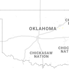
Hail Map for Wednesday, July 27, 2022

Number of Impacted Households on 7/27/2022
0
Impacted by 1" or Larger Hail
0
Impacted by 1.75" or Larger Hail
0
Impacted by 2.5" or Larger Hail
Square Miles of Populated Area Impacted on 7/27/2022
0
Impacted by 1" or Larger Hail
0
Impacted by 1.75" or Larger Hail
0
Impacted by 2.5" or Larger Hail


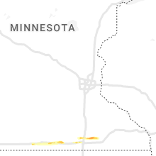


Cities Most Affected by Hail Storms of 7/27/2022
| Hail Size | Demographics of Zip Codes Affected | ||||||
|---|---|---|---|---|---|---|---|
| City | Count | Average | Largest | Pop Density | House Value | Income | Age |
| Wray, CO | 5 | 2.70 | 3.75 | 5 | $72k | $33.4k | 39.1 |
| Fort Collins, CO | 3 | 2.25 | 2.50 | 256 | $176k | $42.7k | 36.0 |
| Wellington, CO | 2 | 1.88 | 2.00 | 33 | $136k | $52.2k | 33.1 |
| Windsor, CO | 1 | 1.75 | 1.75 | 416 | $160k | $54.1k | 37.1 |
| Burns, WY | 1 | 1.75 | 1.75 | 5 | $78k | $40.8k | 41.6 |
Hail and Wind Damage Spotted on 7/27/2022
Filter by Report Type:Hail ReportsWind Reports
States Impacted
Illinois, North Carolina, Missouri, Oklahoma, Wyoming, Nebraska, Colorado, Kentucky, Nevada, KansasIllinois
| Local Time | Report Details |
|---|---|
| 7:00 AM CDT | Trees down in the city of carm in white county IL, 34 miles WNW of Evansville, IN |
North Carolina
| Local Time | Report Details |
|---|---|
| 3:52 PM EDT | Emergency management reported an area of wind damage stretching from the martin county airport east to the intersection of hopkins road and highway 125. damage includes in martin county NC, 84.1 miles SW of Virginia Beach, VA |
| 5:40 PM EDT | A tree was reported down on a house near the intersection of wildflower lane and cavel chub lake roa in person county NC, 48.9 miles NNW of Raleigh, NC |
| 6:40 PM EDT | Trees were reported down on power lines near martin creek road and us highway in vance county NC, 36.9 miles NNE of Raleigh, NC |
| 6:43 PM EDT | Trees were reported down on power lines along pocomoke road near fred wilder roa in franklin county NC, 23.7 miles NNE of Raleigh, NC |
| 6:45 PM EDT | Trees were reported down on power lines near us highway 1 north youngsvill in franklin county NC, 20.1 miles NNE of Raleigh, NC |
| 7:05 PM EDT | Trees and power lines down resulting in power outages on t k allen r in franklin county NC, 32.5 miles NE of Raleigh, NC |
| 7:16 PM EDT | Power outages at leonard rd and old benton way... caused by fallen trees or limbs on power line in franklin county NC, 37.3 miles NE of Raleigh, NC |
| 7:46 PM EDT | Trees were reported down in the enfield are in halifax county NC, 60.7 miles ENE of Raleigh, NC |
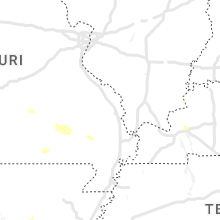
Missouri
| Local Time | Report Details |
|---|---|
| 4:15 PM CDT | Severe thunderstorm wind gusts downed trees along highway m in northern stone count in stone county MO, 19.9 miles SW of Springfield, MO |
| 4:25 PM CDT | Mircroburst wind gusts damaged 2 farm outbuildings and roughly a dozen trees at the monett coop observers location 3 miles south southwest of monett. there was also qua in barry county MO, 44.6 miles WSW of Springfield, MO |
| 4:25 PM CDT | Delayed report: numerous trees down and all power out at montauk state park near salem. 1.01 inches of rain. report via social medi in dent county MO, 15.7 miles SW of Salem, MO |
| 4:35 PM CDT | Severe thunderstorm wind gusts downed 3 large trees into some power lines within the purdy city limit in barry county MO, 43.9 miles SW of Springfield, MO |
| 5:03 PM CDT | Severe thunderstorm wind gusts damaged two poultry houses roughly 1 mile north of butterfiel in barry county MO, 45.7 miles SW of Springfield, MO |
| 5:05 PM CDT | Quarter sized hail reported near Rocky Comfort, MO, 62.1 miles SW of Springfield, MO, there was also strong wind gusts that flipped over a swimming pool. |
| 5:10 PM CDT | Trees dow in barry county MO, 51.7 miles SSW of Springfield, MO |
| 5:17 PM CDT | Corrects previous tstm wnd dmg report from 2 ssw hurley. trees over roadwa in stone county MO, 24.5 miles SSW of Springfield, MO |
| 5:25 PM CDT | Trees over roadwa in stone county MO, 24.5 miles SSW of Springfield, MO |
| 5:33 PM CDT | Corrects previous tstm wnd dmg report from 1 nnw eagle rock. trees dow in barry county MO, 51.7 miles SSW of Springfield, MO |
| 6:28 PM CDT | Trees reported down on power lines. time estimated by rada in wayne county MO, 56.9 miles SE of Salem, MO |
| 6:30 PM CDT | Two trees down near county road 327 and highway in carter county MO, 59.6 miles SE of Salem, MO |
| 7:35 PM CDT | Severe thunderstorm wind gusts downed a tree across county road 9370 near its intersection with highway 6 in howell county MO, 67.7 miles S of Salem, MO |
| 7:50 PM CDT | Electrical line damage in puxico. intersection of church and crumb street in stoddard county MO, 41.8 miles SW of Cape Girardeau, MO |
| 8:45 PM CDT | One tree reported down west kenton roa in stoddard county MO, 41 miles SW of Cape Girardeau, MO |
Oklahoma
| Local Time | Report Details |
|---|---|
| 4:40 PM CDT | Camper blown over and a roof torn off a barn near the intersection of n 433 rd and w 470 rd. time estimated by rada in mayes county OK, 41.4 miles ENE of Tulsa, OK |
| 5:15 PM CDT | 3 high power transmission line structures have been destroyed near the intersection of highway 28 and n 444 rd. highway 28 is currently shutdown due to lines across the in mayes county OK, 54.5 miles ENE of Tulsa, OK |
| 6:00 PM CDT | Power lines downed. time estimated by rada in mayes county OK, 38.8 miles E of Tulsa, OK |
| 6:05 PM CDT | Numerous tree limbs down in glenpool. video relayed via twitter. time estimated by rada in tulsa county OK, 13.1 miles S of Tulsa, OK |
| 6:05 PM CDT | Video of a metal shed damaged and relocated to the side of the road relayed via broadcast media twitter. between 121st and 131st and elwood. time estimated by rada in tulsa county OK, 11.7 miles S of Tulsa, OK |
| 6:10 PM CDT | Tree downed... blocking the westbound lane of old highway 33. relayed by broadcast media. time estimated by rada in mayes county OK, 38.8 miles E of Tulsa, OK |
Wyoming
| Local Time | Report Details |
|---|---|
| 4:16 PM MDT | Mesonet station kwyh 6.5 n natural fort (wydot in laramie county WY, 40.7 miles ESE of Laramie, WY |
| 4:26 PM MDT | Mesonet station kwyh 6.5 n natural fort (wydot in laramie county WY, 40.7 miles ESE of Laramie, WY |
| 4:41 PM MDT | Storm damage reported in laramie county WY, 47.8 miles ESE of Laramie, WY |
| 4:41 PM MDT | Storm damage reported in laramie county WY, 47.8 miles ESE of Laramie, WY |
| 5:25 PM MDT | No hail. very strong wind in laramie county WY, 26.4 miles E of Laramie, WY |
| 5:40 PM MDT | Quarter sized hail reported near Cheyenne, WY, 39.6 miles ESE of Laramie, WY, report from law enforcement on f.e. warren. from 540 to 550 pm quarter sized hail and wind gusts 70 to 75 mph. |
| 5:50 PM MDT | Spotter estimated 60 mph winds with very heavy rainfall and pea-sized hai in laramie county WY, 42.9 miles ESE of Laramie, WY |
| 6:15 PM MDT | Report received via facebook. heavy wooden shed destroye in laramie county WY, 52.8 miles ESE of Laramie, WY |
| 6:43 PM MDT | Golf Ball sized hail reported near Burns, WY, 50.9 miles SW of Scottsbluff, NE, hail currently falling. some golfball sized hail. |
| 8:10 PM MDT | Heavy rain and no hai in platte county WY, 61.1 miles NE of Laramie, WY |
| 8:22 PM MDT | Bordeaux wydot site. gusts 58 mph at 818pm. gusts 65 mph at 820p in platte county WY, 54.4 miles NE of Laramie, WY |
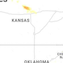
Nebraska
| Local Time | Report Details |
|---|---|
| 4:35 PM MDT | Pea sized hail with sustained winds 40 mph with higher gusts to 58 mp in box butte county NE, 50.4 miles NE of Scottsbluff, NE |
| 7:59 PM MDT | Quarter sized hail reported near Big Springs, NE, 66.2 miles W of North Platte, NE, quarter size hail reported northeast of big springs. |
| 8:02 PM MDT | Storm chaser measured wind gust via anemometer while stationary in keith county NE, 50.2 miles W of North Platte, NE |
| 9:14 PM MDT | Imperial asos report of 81 mph wind gust in chase county NE, 61.9 miles SW of North Platte, NE |
| 11:40 PM CDT | 68 mph thunderstorm wind gust recorded by mesonet station 4 miles n of north platte in lincoln county NE, 3.7 miles N of North Platte, NE |
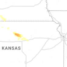
Colorado
| Local Time | Report Details |
|---|---|
| 5:25 PM MDT | Quarter sized hail reported near Nunn, CO, 60 miles SE of Laramie, WY, cocorahs co-we-409. 15 minutes of hail up to quarter size. |
| 5:48 PM MDT | Quarter sized hail reported near Pierce, CO, 64.3 miles NNE of Denver, CO, delayed report... with hail collected over an hour after the storm ended. time estimated by radar. |
| 6:03 PM MDT | Ping Pong Ball sized hail reported near Eaton, CO, 61.6 miles NNE of Denver, CO, storm chaser reported hail at the intersection of state highway 14 and county road 49. time estimated by radar. |
| 6:08 PM MDT | Quarter sized hail reported near Eaton, CO, 60 miles NNE of Denver, CO |
| 7:30 PM MDT | Tea Cup sized hail reported near Wray, CO, 21.2 miles ENE of Yuma, CO, public report via photo on social media of a hail stone next to a tape measure. at maximum diameter... the hail stone seems to be around 3.75 inches. location was near |
| 7:35 PM MDT | Quarter sized hail reported near Wellington, CO, 51.5 miles SE of Laramie, WY, cocorahs co-lr-142. |
| 7:39 PM MDT | Half Dollar sized hail reported near Wellington, CO, 51.9 miles SE of Laramie, WY |
| 7:41 PM MDT | Quarter sized hail reported near Wellington, CO, 51.1 miles SE of Laramie, WY |
| 7:44 PM MDT | Quarter sized hail reported near Pierce, CO, 64.3 miles NNE of Denver, CO, falling at time of report. |
| 7:45 PM MDT | Hen Egg sized hail reported near Wellington, CO, 52.2 miles SE of Laramie, WY, cocorahs co-lr-1146. reported car dents and damaged shingles. |
| 7:45 PM MDT | Ping Pong Ball sized hail reported near Wellington, CO, 52.2 miles SE of Laramie, WY, up to ping pong ball sized hail. the hail damaged at least one window. time estimated. |
| 7:47 PM MDT | Golf Ball sized hail reported near Wellington, CO, 52.8 miles SE of Laramie, WY, report via twitter. time estimated. |
| 7:47 PM MDT | Hen Egg sized hail reported near Fort Collins, CO, 55.1 miles SE of Laramie, WY, report relayed from spotter. |
| 7:53 PM MDT | Ping Pong Ball sized hail reported near Fort Collins, CO, 56.3 miles SE of Laramie, WY, larimer dispatch relayed report of significant damage... including smashed windows... as a result of the hail. time estimated. |
| 8:00 PM MDT | Half Dollar sized hail reported near Fort Collins, CO, 58.7 miles N of Denver, CO, hail blown into house causing some damage. tree limbs also down. |
| 8:00 PM MDT | Large tree limbs dow in larimer county CO, 58.7 miles N of Denver, CO |
| 8:02 PM MDT | Tennis Ball sized hail reported near Fort Collins, CO, 58.6 miles SE of Laramie, WY, off-duty nws employee provided photos of tennis ball size hail... measured 45 minutes after the hail stopped falling. |
| 8:08 PM MDT | Hen Egg sized hail reported near Fort Collins, CO, 58 miles N of Denver, CO, photos of hail at the intersection of mulberry street and county road 15. time estimated. |
| 8:15 PM MDT | Quarter sized hail reported near Wray, CO, 21.4 miles E of Yuma, CO, public report relayed via social media. photo of hail stone next to a quarter. |
| 8:15 PM MDT | Ping Pong Ball sized hail reported near Windsor, CO, 53.6 miles N of Denver, CO, cocorahs co-we-564. |
| 8:17 PM MDT | Tennis Ball sized hail reported near Wray, CO, 23.6 miles E of Yuma, CO, public report via social media with a photo of slightly smaller than tennis ball sized hail on the west side of wray... co. location and size are estimated. |
| 8:17 PM MDT | Tennis Ball sized hail reported near Wray, CO, 23.1 miles E of Yuma, CO, corrects previous hail report from 3 w wray. public report via social media with a photo of slightly smaller than tennis ball sized hail on the west side of wray... co. |
| 8:27 PM MDT | Golf Ball sized hail reported near Windsor, CO, 55 miles N of Denver, CO |
| 8:30 PM MDT | Tea Cup sized hail reported near Wray, CO, 27.3 miles ESE of Yuma, CO, public report via photo on social media of a 3 inch maximum diameter hail stone. photo had the stone next to a tape measure. location was at the intersection of county |
| 8:35 PM MDT | Quarter sized hail reported near Wray, CO, 29.3 miles ESE of Yuma, CO, report of hail up to quarter inch. |
| 8:35 PM MDT | Golf Ball sized hail reported near Wray, CO, 27.3 miles ESE of Yuma, CO, report via social media with a photo of golf-ball sized hail 7 miles south of wray... co on highway 385. timing... location... and magnitude are estimated. |
| 8:37 PM MDT | Ping Pong Ball sized hail reported near Eaton, CO, 54.3 miles N of Denver, CO, photo of 1.6 inch diameter hail. |
| 8:48 PM MDT | Ping Pong Ball sized hail reported near Bellvue, CO, 54.2 miles S of Laramie, WY, relayed report from the crystal mountain area. also recorded over a half inch of rain in 15 minutes. time estimated. |
| 8:49 PM MDT | Quarter sized hail reported near Wray, CO, 18.7 miles E of Yuma, CO, hail up to quarter size. |
| 8:50 PM MDT | Quarter sized hail reported near Wray, CO, 19.4 miles E of Yuma, CO, nickel and quarter sized hail. |
| 9:24 PM MDT | Quarter sized hail reported near Wray, CO, 33.5 miles ESE of Yuma, CO, social media report of pea size and quarter size hail at beecher island. |
| 9:47 PM MDT | Mesonet station co047 385n220 idali in yuma county CO, 35.4 miles SE of Yuma, CO |
| 10:00 PM MDT | Quarter sized hail reported near Boulder, CO, 29.4 miles NW of Denver, CO |
| 11:09 PM MDT | Mesonet station co007 littleton c470/wadswort in jefferson county CO, 13.9 miles SSW of Denver, CO |
| 11:23 PM MDT | Quarter sized hail reported near Littleton, CO, 12.5 miles S of Denver, CO |
| 11:28 PM MDT | Quarter sized hail reported near Castle Rock, CO, 17.9 miles SSE of Denver, CO, report from mping: quarter (1.00 in.). time estimated. |
| 11:33 PM MDT | Mesonet station co073 1.2 mi n of castle pines parkway. also recorded a sustained wind of 47mp in douglas county CO, 19.1 miles SSE of Denver, CO |
| 11:44 PM MDT | Quarter sized hail reported near Parker, CO, 16.9 miles SE of Denver, CO, report from mping: quarter (1.00 in.). |
| 12:15 AM MDT | Quarter sized hail reported near Akron, CO, 25.8 miles W of Yuma, CO |
Kentucky
| Local Time | Report Details |
|---|---|
| 6:40 PM CDT | Report of a tree down in the windfield communit in edmonson county KY, 67.5 miles SSW of Louisville, KY |
| 6:43 PM CDT | Via social media - image of fallen tree off home chapel r in logan county KY, 55.3 miles N of Nashville, TN |
| 6:43 PM CDT | Relayed a public report. several trees down at davis crossroads in southern butler county. an older barn was also los in butler county KY, 60.9 miles N of Nashville, TN |
| 7:49 PM EDT | Image of tree down on east brown st. blocking the road on a bridge. via social medi in jessamine county KY, 34.9 miles WNW of Irvine, KY |
Nevada
| Local Time | Report Details |
|---|---|
| 6:06 PM PDT | Nvdot sensor measured a gust to 58 mph ahead of thunderstorm in clark county NV, 48.7 miles NE of Las Vegas, NV |
| 7:30 PM PDT | Tree down due to thunderstorm related wind gust in clark county NV, 4.7 miles NW of Las Vegas, NV |
| 7:32 PM PDT | North las vegas airport gusted to 59 mph from nearby thunderstorm in clark county NV, 3.8 miles NW of Las Vegas, NV |
| 7:40 PM PDT | Harry reid international airport gusted to 60 mph from nearby thunderstorm in clark county NV, 7.1 miles S of Las Vegas, NV |
| 7:52 PM PDT | Nellis air force base gusted to 60 mph due to nearby thunderstorm in clark county NV, 7.3 miles ENE of Las Vegas, NV |
| 7:57 PM PDT | Gust to 60 mph on the east side of the las vegas valley from nearby thunderstorms. data courtesy of earthnetwork in clark county NV, 6.2 miles E of Las Vegas, NV |
| 8:00 PM PDT | Desert shrub dri sensor measured a gust to 60 mph from nearby thunderstorm in clark county NV, 22.2 miles NNW of Las Vegas, NV |
| 8:00 PM PDT | Over 7000 people without power at time of report. increased to over 10000 without power at 2115. power lines down in north las vegas due to thunderstorm related wind gu in clark county NV, 3.9 miles ENE of Las Vegas, NV |
Kansas
| Local Time | Report Details |
|---|---|
| 9:35 PM CDT | Site cw8810 ... northwest of elkhar in morton county KS, 86.5 miles SW of Garden City, KS |
| 4:40 AM CDT | Reported strong wind and power was ou in ottawa county KS, 61.8 miles W of Manhattan, KS |
| 4:40 AM CDT | Observer reported that part of a large healthy tree was blown down and onto the power lines which caused a power outag in ottawa county KS, 61.2 miles W of Manhattan, KS |
| 5:28 AM CDT | No damage reported but confident in severe level wind gust in dickinson county KS, 39.2 miles WSW of Manhattan, KS |
Connect with Interactive Hail Maps