

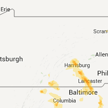
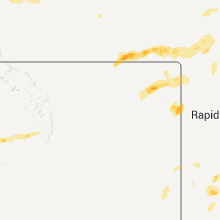
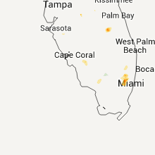
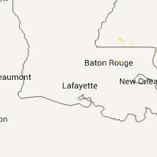
Hail Map for Sunday, June 12, 2011

Number of Impacted Households on 6/12/2011
0
Impacted by 1" or Larger Hail
0
Impacted by 1.75" or Larger Hail
0
Impacted by 2.5" or Larger Hail
Square Miles of Populated Area Impacted on 6/12/2011
0
Impacted by 1" or Larger Hail
0
Impacted by 1.75" or Larger Hail
0
Impacted by 2.5" or Larger Hail


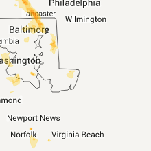

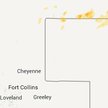
Cities Most Affected by Hail Storms of 6/12/2011
| Hail Size | Demographics of Zip Codes Affected | ||||||
|---|---|---|---|---|---|---|---|
| City | Count | Average | Largest | Pop Density | House Value | Income | Age |
| Biddle, MT | 3 | 3.75 | 4.25 | 0 | $43k | $24.2k | 48.5 |
| Alzada, MT | 3 | 2.00 | 2.50 | 0 | $138k | $33.8k | 52.5 |
| Fort Lauderdale, FL | 3 | 1.75 | 1.75 | 2732 | $167k | $72.5k | 39.9 |
| Jefferson City, MO | 1 | 2.00 | 2.00 | 475 | $99k | $45.0k | 38.2 |
| Mexico, MO | 1 | 1.75 | 1.75 | 67 | $67k | $33.0k | 38.9 |
| Glen Ullin, ND | 1 | 1.75 | 1.75 | 1 | $34k | $28.6k | 51.0 |
| Stuart, VA | 1 | 1.75 | 1.75 | 38 | $76k | $30.3k | 48.1 |
| Salem, SC | 1 | 1.75 | 1.75 | 77 | $221k | $48.2k | 60.7 |
| King George, VA | 1 | 1.75 | 1.75 | 129 | $123k | $50.3k | 37.3 |
| Mandan, ND | 1 | 1.75 | 1.75 | 38 | $83k | $39.5k | 37.6 |
Hail and Wind Damage Spotted on 6/12/2011
Filter by Report Type:Hail ReportsWind Reports
States Impacted
South Carolina, Pennsylvania, Virginia, West Virginia, North Carolina, Maryland, Georgia, Mississippi, Florida, Wyoming, Alabama, Montana, South Dakota, Texas, North Dakota, Nebraska, MissouriSouth Carolina
| Local Time | Report Details |
|---|---|
| 1:48 PM UTC | Trees down at intersection of salters town road and highway us 76 in sumter county SC, 52.9 miles NNW of Charleston, SC |
| 7:25 PM UTC | Golf Ball sized hail reported near Salem, SC, 18.4 miles WNW of Greenville, SC, golf ball sized hail falling at hw-11 at lake keowee. hail is still occurring. |
| 7:43 PM UTC | About 20 trees uprooted and down across highlands highway...sc route 2 in oconee county SC, 31.2 miles W of Greenville, SC |
| 7:45 PM UTC | 3 large trees down on property along forest roa in oconee county SC, 30.7 miles W of Greenville, SC |
| 7:53 PM UTC | Trees down and structural damage on deborahs wa in oconee county SC, 29.7 miles WSW of Greenville, SC |
| 8:10 PM UTC | Trees down near intersection of sc highway 11 and boones creek roa in oconee county SC, 20.2 miles WNW of Greenville, SC |
| 8:19 PM UTC | Multiple trees down on mountain view and meadow fork roads in greenville county SC, 21 miles NE of Greenville, SC |
| 8:25 PM UTC | Tree blown down blocking hwy 912 near calahan mountain rd in greenville county SC, 18.2 miles NE of Greenville, SC |
| 8:25 PM UTC | Tree blown down blocking hwy 912 near calahan mountain rd in greenville county SC, 24.4 miles NNE of Greenville, SC |
| 8:44 PM UTC | Trees down on old liberty rd and hwy 135 sout in pickens county SC, 1 miles SE of Greenville, SC |
| 8:52 PM UTC | Brief sustained wind of 50 mph in spartanburg county SC, 27 miles ENE of Greenville, SC |
| 9:05 PM UTC | Tree down on a house on james cour in spartanburg county SC, 38.8 miles ENE of Greenville, SC |
| 9:52 PM UTC | Tree down in union county SC, 49.7 miles E of Greenville, SC |
| 10:02 PM UTC | A tree fell onto power lines and took down some poles as well in union county SC, 52.9 miles E of Greenville, SC |
| 10:45 PM UTC | Trees down in york county SC, 22.3 miles SSW of Charlotte, NC |
| 12:56 AM UTC | Trees down in marlboro county SC, 66.8 miles ESE of Charlotte, NC |
| 1:21 AM UTC | Trees down on airbase road and congaree road near mcentire ang base in richland county SC, 67.1 miles NW of Charleston, SC |
| 1:45 AM UTC | Trees down on gaddys mill road in dillon county SC, 76.7 miles W of Wilmington, NC |
| 1:46 AM UTC | Trees down on arnette road in dillon county SC, 76.2 miles W of Wilmington, NC |
| 1:48 AM UTC | Trees down at 1200 block of pleasant grove road in sumter county SC, 54.7 miles N of Charleston, SC |
| 1:48 AM UTC | Trees down at 2200 block of pleasant grove road in sumter county SC, 54.7 miles N of Charleston, SC |
| 1:48 AM UTC | Trees down on u.s. highway 76 at east brewington road in sumter county SC, 48.9 miles NNW of Charleston, SC |
| 1:48 AM UTC | Quarter sized hail reported near Sumter, SC, 44.8 miles NNW of Charleston, SC, public reported 1.00 inch hail. |
| 2:21 AM UTC | Trees down in the northbound lane of i-95 at mile marker 121 in clarendon county SC, 38.2 miles NNW of Charleston, SC |
| 2:21 AM UTC | Trees down in the northbound lane of i-95 in clarendon county SC, 38.2 miles NNW of Charleston, SC |
Pennsylvania
| Local Time | Report Details |
|---|---|
| 1:45 PM EDT | Quarter sized hail reported near Watts, PA, 52.5 miles ESE of State College, PA |
| 1:55 PM EDT | Quarter sized hail reported near Halifax, PA, 53.8 miles ESE of State College, PA |
| 3:07 PM EDT | Quarter sized hail reported near Newberry, PA, 58.7 miles N of Baltimore, MD, one inch size hail at etters... pa |
| 3:07 PM EDT | Quarter sized hail reported near Londonderry, PA, 60.1 miles N of Baltimore, MD, one inch size hail at etters... pa |
| 7:12 PM UTC | Trees down in york county PA, 48.9 miles N of Baltimore, MD |
| 7:12 PM UTC | Trees down. possible funnel cloud reported just north of wrightsvill in york county PA, 50.5 miles N of Baltimore, MD |
| 7:12 PM UTC | Numerous reports of trees down in springettsbury township in york county PA, 47.8 miles N of Baltimore, MD |
| 7:15 PM UTC | Numerous trees down in york township in york county PA, 45.1 miles N of Baltimore, MD |
| 7:20 PM UTC | Trees down. tree on house in windsor township in york county PA, 42.7 miles N of Baltimore, MD |
| 7:25 PM UTC | Trees down. metal shed blown onto route 79 in york county PA, 42 miles N of Baltimore, MD |
| 7:50 PM UTC | Construction trailer blown onto roadway in york county PA, 42 miles N of Baltimore, MD |
| 7:51 PM UTC | Tree limbs and power lines down in york county PA, 42 miles N of Baltimore, MD |
Virginia
| Local Time | Report Details |
|---|---|
| 6:00 PM UTC | Fallen trees caused significant damage to several mobile homes and vehicles in the country estates trailer park in augusta county VA, 75.7 miles SE of Elkins, WV |
| 6:52 PM UTC | Trees down along charlottesville bypass hwy 250 in albemarle county VA, 59 miles NW of Richmond, VA |
| 7:01 PM UTC | Golf Ball sized hail reported near Stuart, VA, 39.8 miles SSW of Roanoke, VA, received a report of golfball size hail causing damage to screen fixtures of a home. |
| 7:16 PM UTC | One tree blown down in patrick spring in patrick county VA, 46.4 miles SSW of Roanoke, VA |
| 7:27 PM UTC | Cedar tree blown down in backyard of observers house located along mayfield drive in city of lynchburg county VA, 39.8 miles E of Roanoke, VA |
| 7:27 PM UTC | Several trees down in apartment complex off lakeside drive near the intersection of route 501 in city of lynchburg county VA, 40.7 miles ENE of Roanoke, VA |
| 7:33 PM UTC | Wires dow in loudoun county VA, 55.3 miles W of Baltimore, MD |
| 7:36 PM UTC | Trees down for a one mile stretch along route 151 between piney river and clifford in amherst county VA, 57.9 miles ENE of Roanoke, VA |
| 7:40 PM UTC | Thunderstorm wind gust measured with a home weather statio in buckingham county VA, 64.3 miles W of Richmond, VA |
| 7:42 PM UTC | Large limb down into southbound lane of va route 9 in loudoun county VA, 59.4 miles W of Baltimore, MD |
| 7:44 PM UTC | Trees and wires down in the 38000 block of va route 9 in loudoun county VA, 58.4 miles W of Baltimore, MD |
| 7:45 PM UTC | A tree was blown down along state route 64 in buckingham county VA, 50.7 miles W of Richmond, VA |
| 7:53 PM UTC | Tree down in pittsylvania county VA, 29.3 miles SE of Roanoke, VA |
| 8:00 PM UTC | Tree on house in 20000 block of furr rd in loudoun county VA, 66 miles WSW of Baltimore, MD |
| 8:05 PM UTC | One tree was down on a home along woodcreek roa in bedford county VA, 24 miles ENE of Roanoke, VA |
| 8:05 PM UTC | Trees down along st louis road and foxcroft rd in loudoun county VA, 65.1 miles WSW of Baltimore, MD |
| 8:09 PM UTC | Trees down along snickersville turnpike in loudoun county VA, 62.7 miles WSW of Baltimore, MD |
| 8:09 PM UTC | Trees down along polecat hill road in loudoun county VA, 63.7 miles WSW of Baltimore, MD |
| 8:15 PM UTC | Bedford county sheriffs department has reported multiple trees down along forest road near the bedford city limit in city of bedford county VA, 24.7 miles E of Roanoke, VA |
| 8:15 PM UTC | Several trees were blown down on mayfield driv in city of lynchburg county VA, 39.8 miles E of Roanoke, VA |
| 8:15 PM UTC | A very large oak tree was uprooted on gaddy roa in city of lynchburg county VA, 40 miles ENE of Roanoke, VA |
| 8:25 PM UTC | Several large branches downed in the neighborhood... knocking out power. half inch hail was also observed... along with 1.84 inches of rain in 30 minute in city of lynchburg county VA, 41.5 miles E of Roanoke, VA |
| 8:27 PM UTC | Cedar tree blown down in backyard of observers house located along mayfield drive in city of lynchburg county VA, 39.8 miles E of Roanoke, VA |
| 8:27 PM UTC | Several trees down in apartment complex off lakeside drive near the intersection of route 501 in city of lynchburg county VA, 40.7 miles ENE of Roanoke, VA |
| 8:30 PM UTC | Tree down at intersection of route 45 and salem church roa in cumberland county VA, 38.8 miles W of Richmond, VA |
| 8:33 PM UTC | Power lines down on lynx driv in campbell county VA, 39.9 miles E of Roanoke, VA |
| 8:34 PM UTC | One tree down on candlers mountain roa in campbell county VA, 43.7 miles E of Roanoke, VA |
| 8:45 PM UTC | Tree down on singletons way in fairfax county VA, 54.4 miles SW of Baltimore, MD |
| 8:49 PM UTC | A tree was blown down along county road 78 in campbell county VA, 40.8 miles E of Roanoke, VA |
| 8:52 PM UTC | Tree down on compton rd at briarcroft rd in fairfax county VA, 54.8 miles SW of Baltimore, MD |
| 8:55 PM UTC | Tree down on main st in fairfax county VA, 54.8 miles SW of Baltimore, MD |
| 8:56 PM UTC | One tree blown down along oak ridge roa in campbell county VA, 36.5 miles ESE of Roanoke, VA |
| 8:58 PM UTC | One tree blown down onto a power line along lewis ford roa in campbell county VA, 55.5 miles E of Roanoke, VA |
| 9:00 PM UTC | Tree onto house on manasses circle in vienna in fairfax county VA, 43.7 miles SW of Baltimore, MD |
| 9:40 PM UTC | Received a report from the public of 2 trees down along father judge roa in amherst county VA, 48.3 miles ENE of Roanoke, VA |
| 9:47 PM UTC | A tree was blown down along state route 74 in halifax county VA, 70.6 miles ESE of Roanoke, VA |
| 9:53 PM UTC | Tree down on mount laurel road near clover in halifax county VA, 72.2 miles N of Raleigh, NC |
| 10:02 PM UTC | Tree down in city of lynchburg county VA, 41.2 miles ENE of Roanoke, VA |
| 10:20 PM UTC | Quarter sized hail reported near , , 32 miles WNW of Virginia Beach, VA, very heavy rain and high winds |
| 10:33 PM UTC | Tree down near intersection of kings hwy and james madison pkwy in king george county VA, 57.7 miles NNE of Richmond, VA |
| 10:48 PM UTC | Large tree fell on a vehicle with people trapped inside the vehicle. no injurie in westmoreland county VA, 63.9 miles NE of Richmond, VA |
| 10:48 PM UTC | Quarter sized hail reported near Colonial Beach, VA, 63.9 miles NE of Richmond, VA |
| 6:51 PM EDT | Golf Ball sized hail reported near King George, VA, 56.4 miles NNE of Richmond, VA |
| 11:00 PM UTC | Widespread trees and powerlines down. 911 center inundated with call in westmoreland county VA, 59.2 miles NE of Richmond, VA |
| 11:55 PM UTC | Two trees down on west river roa in king william county VA, 36 miles NE of Richmond, VA |
West Virginia
| Local Time | Report Details |
|---|---|
| 6:20 PM UTC | A few trees down in morgan county WV, 87.6 miles ENE of Elkins, WV |
| 6:21 PM UTC | Large limbs down with a lot of small limb debris in morgan county WV, 87.8 miles ENE of Elkins, WV |
| 7:10 PM UTC | Tree knocked down onto powerlines at 15000 block of leetown roa in jefferson county WV, 69.9 miles W of Baltimore, MD |
| 7:10 PM UTC | Tree knocked down onto powerline in jefferson county WV, 69.9 miles W of Baltimore, MD |
| 7:12 PM UTC | Tree blown over across railroad tracks near stubbs roa in jefferson county WV, 68.3 miles W of Baltimore, MD |
| 7:22 PM UTC | Trees down in the bakerton area in jefferson county WV, 63.9 miles W of Baltimore, MD |
North Carolina
| Local Time | Report Details |
|---|---|
| 6:30 PM UTC | Countywide fire/ems dispatch reported multiple calls of trees down in the skyland are in buncombe county NC, 45 miles N of Greenville, SC |
| 7:24 PM UTC | Two trees blown down along shepherds crossroad in wilkes county NC, 70.1 miles ESE of Bristol, TN |
| 7:25 PM UTC | The stokes county sheriffs office reported a tree blown down onto powerlines along amostown r in stokes county NC, 51.4 miles S of Roanoke, VA |
| 7:25 PM UTC | The stokes county sheriffs office reported a tree blown down on anglin mill roa in rockingham county NC, 50.6 miles S of Roanoke, VA |
| 7:33 PM UTC | At least five trees down...mainly around and s of hendersonville. one on a house near etowa in henderson county NC, 34.6 miles NNE of Greenville, SC |
| 7:55 PM UTC | The stokes county sheriffs office reports a tree blown down along k fork roa in rockingham county NC, 60.3 miles S of Roanoke, VA |
| 8:11 PM UTC | Tree down in yadkin county NC, 69.3 miles N of Charlotte, NC |
| 8:15 PM UTC | Fire marshall office reported 2 trees down 5-6 miles apart in the northeast part of the count in rutherford county NC, 59.1 miles WNW of Charlotte, NC |
| 8:20 PM UTC | One tree down in rockingham county NC, 55.3 miles S of Roanoke, VA |
| 8:36 PM UTC | Quarter sized hail reported near Catawba, NC, 36.3 miles NNW of Charlotte, NC, hail up to the size of quarters on oxford school road between catawba and i-40. |
| 8:41 PM UTC | One tree down on i-4 in catawba county NC, 36.3 miles NNW of Charlotte, NC |
| 8:49 PM UTC | One tree down in rockingham county NC, 55.3 miles S of Roanoke, VA |
| 9:00 PM UTC | A few large limbs down in road near intersection of us hwy 70 and us hwy 2 in iredell county NC, 39.2 miles N of Charlotte, NC |
| 9:02 PM UTC | Power lines down in watauga county NC, 34.9 miles SE of Bristol, TN |
| 9:05 PM UTC | A few trees down in nw part of count in rowan county NC, 36.1 miles NNE of Charlotte, NC |
| 10:20 PM UTC | 911 comm reports one tree down in bethlehe in alexander county NC, 47.9 miles NNW of Charlotte, NC |
| 10:48 PM UTC | Tree down in rowan county NC, 33.9 miles NNE of Charlotte, NC |
| 10:50 PM UTC | Conover fd reported multiple trees down in claremont in the i-40 are in catawba county NC, 37.9 miles NNW of Charlotte, NC |
| 11:00 PM UTC | One tree reported down on nc highway 109 near eldorado in montgomery county NC, 48.7 miles ENE of Charlotte, NC |
| 11:00 PM UTC | Several trees down in northern stanly county and a power pole on a ca in stanly county NC, 38.8 miles ENE of Charlotte, NC |
| 12:00 AM UTC | Tree reported down on blonnie ross rd west of burnsville. time estimate in anson county NC, 33 miles ESE of Charlotte, NC |
| 12:19 AM UTC | Five large trees down in clayto in johnston county NC, 13.9 miles SSE of Raleigh, NC |
| 12:22 AM UTC | Tree on a car in wadesboro on highway 74 with a person trapped. a portion of highway 74 is closed. numerous trees down in the are in anson county NC, 46.8 miles ESE of Charlotte, NC |
| 12:34 AM UTC | Multiple trees blown down on power lines on nc highway 109 near global rd. transformer fire reported. time estimate in anson county NC, 45.6 miles ESE of Charlotte, NC |
| 12:39 AM UTC | Large tree down on nc highway 145 near diggs rd in anson county NC, 54.3 miles ESE of Charlotte, NC |
| 12:44 AM UTC | Several trees down along highway 1 south near the south carolina lin in richmond county NC, 60.8 miles ESE of Charlotte, NC |
| 12:54 AM UTC | Tree down. time estimate in richmond county NC, 66.8 miles ESE of Charlotte, NC |
| 1:08 AM UTC | Trees down on highway in robeson county NC, 82.4 miles SSW of Raleigh, NC |
| 1:26 AM UTC | Trees down in robeson county NC, 77.9 miles WNW of Wilmington, NC |
| 1:34 AM UTC | Tree limb down on a power pole with fire on third st near 74 business. power out in area. time estimate in scotland county NC, 83.6 miles SSW of Raleigh, NC |
| 1:39 AM UTC | Tree blown down. time estimate in scotland county NC, 74.3 miles SW of Raleigh, NC |
| 1:47 AM UTC | Trees down in robeson county NC, 66.6 miles WNW of Wilmington, NC |
| 1:56 AM UTC | Trees down in robeson county NC, 69.5 miles WNW of Wilmington, NC |
Maryland
| Local Time | Report Details |
|---|---|
| 6:56 PM UTC | Large tree down on power lines on mill point rd in washington county MD, 59.6 miles WNW of Baltimore, MD |
| 7:25 PM UTC | Tree knocked down and blocking roadway at intersection of clarkes landing road and placid harbor roa in st. marys county MD, 65.8 miles S of Baltimore, MD |
| 7:30 PM UTC | Tree blocking intersection of hg trueman road and southern connector blvd in lusby... m in calvert county MD, 64.8 miles S of Baltimore, MD |
| 4:18 PM EDT | Quarter sized hail reported near Pylesville, MD, 29.5 miles NNE of Baltimore, MD |
| 4:18 PM EDT | Quarter sized hail reported near Aberdeen, MD, 22.2 miles ENE of Baltimore, MD |
| 8:20 PM UTC | Multiple trees down over a large area near grier nursery road and holy cross roa in harford county MD, 28.9 miles NNE of Baltimore, MD |
| 8:20 PM UTC | Several large trees 6 to 12 inches in diameter uprooted in a 1 mile area. smaller trees have also been uprooted or damage in harford county MD, 28.2 miles NNE of Baltimore, MD |
| 8:27 PM UTC | Md-rt 543 near gibson rd closed due to downed trees in harford county MD, 25.8 miles NE of Baltimore, MD |
| 8:27 PM UTC | Trees down near sandy hook rd and tucker r in harford county MD, 29 miles NE of Baltimore, MD |
| 8:27 PM UTC | Vehicles blocked between two trees knocked down near the 2900 block of grier nursery roa in harford county MD, 25.2 miles NNE of Baltimore, MD |
| 8:27 PM UTC | Trees down near sandy hook road and walters mill roa in harford county MD, 26.9 miles NE of Baltimore, MD |
| 8:50 PM UTC | Over a dozen large trees uprooted and damaged. powerlines down nearb in harford county MD, 23.8 miles ENE of Baltimore, MD |
| 9:03 PM UTC | Multiple trees down in northern parts of baltimor in baltimore city county MD, 0.6 miles N of Baltimore, MD |
| 9:12 PM UTC | Trees down in eastern parts of baltimor in baltimore city county MD, 0.6 miles N of Baltimore, MD |
| 9:40 PM UTC | Multiple trees down and various wind damage reported in and around indian hea in charles county MD, 56.1 miles SSW of Baltimore, MD |
| 9:40 PM UTC | Trellis was destroye in charles county MD, 56.4 miles SSW of Baltimore, MD |
| 9:44 PM UTC | Tree down near serenity ln and sweetman rd in charles county MD, 59.1 miles SSW of Baltimore, MD |
| 9:45 PM UTC | Tree down across roa in kent county MD, 37.1 miles E of Baltimore, MD |
| 10:10 PM UTC | Trees down in church hil in queen anne's county MD, 34.8 miles ESE of Baltimore, MD |
| 10:48 PM UTC | Thunderstorm wind gusts were estimated to be 60 to 65 mph in ridgel in caroline county MD, 45.2 miles ESE of Baltimore, MD |
| 11:00 PM UTC | Trees down and power outage in caroline county MD, 51 miles ESE of Baltimore, MD |
Georgia
| Local Time | Report Details |
|---|---|
| 7:20 PM UTC | Several trees down...many cut in half in rabun county GA, 46 miles W of Greenville, SC |
| 9:45 PM UTC | County warning point reported 3 trees down near post office. time estimated by rada in bryan county GA, 23.6 miles W of Savannah, GA |
| 9:53 PM UTC | Warning point reported trees dow in tattnall county GA, 50.2 miles W of Savannah, GA |
| 1:25 AM UTC | 4 trees down including 1 tree on a house in hahira. some powerlines down as wel in lowndes county GA, 47 miles SW of Douglas, GA |
Mississippi
| Local Time | Report Details |
|---|---|
| 7:35 PM UTC | A utility pole was snapped along old canton rd in the deerfield area. pea sized hail also occurred during the stor in madison county MS, 17.3 miles NNE of Jackson, MS |
| 8:20 PM UTC | Multiple trees downed in the topeka area...including one that fell on a house. time estimate in lawrence county MS, 60.5 miles S of Jackson, MS |
| 8:40 PM UTC | 2 homes with roof damage and numerous trees down in stringe in jasper county MS, 60.9 miles ESE of Jackson, MS |
| 12:26 AM UTC | An oak tree and small pine tree blown down by microburst on west side of harrison county just north of i-1 in hancock county MS, 51.5 miles NE of New Orleans, LA |
| 12:26 AM UTC | An oak tree and small pine tree blown down by microburst on west side of harrison county just north of i-1 in harrison county MS, 56.1 miles ENE of New Orleans, LA |
Florida
| Local Time | Report Details |
|---|---|
| 7:38 PM UTC | Quarter sized hail reported near Miramar, FL, 18.6 miles NNW of Miami, FL, an off-duty national weather service employee reported quarter-sized hail in miramar near sw 18th street. |
| 3:46 PM EDT | Quarter sized hail reported near Pembroke Pines, FL, 20.4 miles NNW of Miami, FL, an off-duty national weather service employee reported quarter-sized hail in pembroke pines. |
| 7:49 PM UTC | An off-duty national weather service employee reported wind speeds estimated to be greater than 60 mph and quarter-sized hai in broward county FL, 20.4 miles NNW of Miami, FL |
| 4:00 PM EDT | A broadcast media weatherbug station recorded a wind gust of 62 mph at falcon cove middle school. time estimated from radar dat in broward county FL, 27.9 miles NNW of Miami, FL |
| 4:00 PM EDT | A broadcast media weatherbug station at cypress bay high school recorded a wind gust of 64 mph. sustained winds of 45 mph were measured at 355 pm edt. time of wind gust in broward county FL, 27.9 miles NNW of Miami, FL |
| 4:00 PM EDT | Golf Ball sized hail reported near Southwest Ranches, FL, 22.8 miles NNW of Miami, FL, a member of the public reported golf ball-sized hail near the intersection of i-75 and sheridan street. |
| 4:04 PM EDT | Golf Ball sized hail reported near Weston, FL, 27.9 miles NNW of Miami, FL, a member of the public reported golf ball-sized hail on griffin road in weston. estimated wind speeds of 50 mph were also reported. |
| 4:10 PM EDT | A member of the public estimated wind gusts around 60 mph near the intersection of indian trace and bonaventure in weston at 410 pm ed in broward county FL, 27.9 miles NNW of Miami, FL |
| 8:10 PM UTC | A skywarn spotter reported that established trees were downed across sunrise and weston. numerous pieces of foliage in varying sizes from small up to large palm fronds in broward county FL, 30.5 miles N of Miami, FL |
| 4:10 PM EDT | Golf Ball sized hail reported near Weston, FL, 27.9 miles NNW of Miami, FL, a member of the public reported increasing hail sizes near the intersection of indian trace and bonaventure in weston. dime-sized hail began around 400 pm edt and incre |
| 8:46 PM UTC | Half Dollar sized hail reported near Jasper, FL, 71.1 miles E of Tallahassee, FL, the law enforcment received reports of half dollar sized hail and tree damage near county road 751 southwest of jasper. |
| 9:00 PM UTC | The law enforcement reported that powerlines were blown down in the northwest portion of the county. the time given was based on rada in suwannee county FL, 71.1 miles E of Tallahassee, FL |
| 10:45 PM UTC | 40x20 stables destroyed and blown approximately 30 feet from original locatio in manatee county FL, 27.1 miles E of Bradenton, FL |
| 10:59 PM UTC | Quarter sized hail reported near Lake Wales, FL, 46.8 miles SSW of Orlando, FL, public report of nickel to one inch size hail near w lake wales rd s. |
Wyoming
| Local Time | Report Details |
|---|---|
| 8:27 PM UTC | Power outage at this location due to strong wind in fremont county WY, 3 miles W of Riverton, WY |
| 8:34 PM UTC | Small tree branches blown dow in fremont county WY, 2.2 miles WNW of Riverton, WY |
| 8:34 PM UTC | Four inch branches blown off tree. possible street sign blown dow in fremont county WY, 2.2 miles WNW of Riverton, WY |
| 9:55 PM UTC | Quarter sized hail reported near Weston, WY, 46.8 miles N of Gillette, WY |
| 10:03 PM UTC | Half Dollar sized hail reported near Gillette, WY, 0.3 miles SE of Gillette, WY, reported on west side of town |
| 10:06 PM UTC | Golf Ball sized hail reported near , , 49.4 miles N of Gillette, WY, quarter to golf ball sized hail. |
| 10:07 PM UTC | Quarter sized hail reported near Ten Sleep, WY, 70.6 miles NE of Riverton, WY |
| 10:15 PM UTC | Storm damage reported in campbell county WY, 28.1 miles SSE of Gillette, WY |
| 10:15 PM UTC | Storm damage reported in campbell county WY, 28.1 miles SSW of Gillette, WY |
| 11:05 PM UTC | Storm damage reported in crook county WY, 37.2 miles ENE of Gillette, WY |
| 11:05 PM UTC | 5 to 10 minutes of wind broke off limbs on cottonwood trees...up to 25 inches in diameter. also had dime size hai in crook county WY, 44.3 miles ENE of Gillette, WY |
| 11:10 PM UTC | Storm damage reported in crook county WY, 44.3 miles ENE of Gillette, WY |
| 11:10 PM UTC | Storm damage reported in crook county WY, 45.2 miles ENE of Gillette, WY |
| 11:10 PM UTC | Half Dollar sized hail reported near Devils Tower, WY, 44.3 miles ENE of Gillette, WY |
| 11:10 PM UTC | Half Dollar sized hail reported near Sundance, WY, 45.2 miles ENE of Gillette, WY |
| 11:18 PM UTC | Quarter sized hail reported near Hulett, WY, 52.1 miles ENE of Gillette, WY, marble to quarter size hail covered the ground. also heavy rain. |
Alabama
| Local Time | Report Details |
|---|---|
| 9:15 PM UTC | A few trees were blown down in deatsville. winds were estimated around 50 mp in elmore county AL, 53.6 miles W of Auburn, AL |
| 9:45 PM UTC | A few trees were blown down in millbrook. winds estimated around 50 mp in elmore county AL, 52.6 miles W of Auburn, AL |
Montana
| Local Time | Report Details |
|---|---|
| 9:30 PM UTC | Grapefruit sized hail reported near Biddle, MT, 56.2 miles N of Gillette, WY |
| 9:40 PM UTC | Grapefruit sized hail reported near Biddle, MT, 56.2 miles N of Gillette, WY |
| 9:42 PM UTC | Quarter sized hail reported near Winnett, MT, 74.2 miles N of Billings, MT, several pea sized stones with a few larger. the largest stone was 1 inch in diameter. |
| 9:43 PM UTC | Baseball sized hail reported near Biddle, MT, 56.3 miles N of Gillette, WY |
| 9:53 PM UTC | Ping Pong Ball sized hail reported near Biddle, MT, 51.6 miles N of Gillette, WY, hailed for 10 minutes...pea to ping pong ball sized. |
| 10:55 PM UTC | Tennis Ball sized hail reported near Alzada, MT, 66.2 miles NNE of Gillette, WY |
| 11:10 PM UTC | Golf Ball sized hail reported near Alzada, MT, 70.7 miles NNE of Gillette, WY, spotter reports golfball size hail on hwy 212 west of alzada. |
| 11:10 PM UTC | Golf Ball sized hail reported near Alzada, MT, 63.4 miles NE of Gillette, WY, spotter reports golfball size hail on hwy 212 west of alzada. |
| 11:15 PM UTC | Quarter sized hail reported near Volborg, MT, 54.2 miles SE of Miles City, MT |
| 11:45 PM UTC | Storm damage reported in carter county MT, 83.9 miles NE of Gillette, WY |
| 2:05 AM UTC | Quarter sized hail reported near Bozeman, MT, 3.4 miles S of Bozeman, MT, measured quarter sized hail with storm. |
South Dakota
| Local Time | Report Details |
|---|---|
| 9:50 PM UTC | Quarter sized hail reported near Hot Springs, SD, 49 miles SSW of Rapid City, SD |
| 10:30 PM UTC | Storm damage reported in custer county SD, 27 miles S of Rapid City, SD |
| 10:40 PM UTC | Storm damage reported in custer county SD, 29.3 miles S of Rapid City, SD |
| 11:05 PM UTC | Storm damage reported in custer county SD, 28.6 miles SE of Rapid City, SD |
| 11:35 PM UTC | Storm damage reported in pennington county SD, 39.3 miles ESE of Rapid City, SD |
| 12:12 AM UTC | Reported by indian butte raws...inbs2. time estimated based on radar. tornadic signature on radar passed about 3 miles to the nort in harding county SD, 84.1 miles NNW of Rapid City, SD |
| 12:20 AM UTC | Wind moved unoccupied outhouse 100 yard in butte county SD, 80.7 miles NNW of Rapid City, SD |
| 12:50 AM UTC | Two road construction signs and some cones were blown 500 feet into a fiel in harding county SD, 84.9 miles N of Rapid City, SD |
| 12:50 AM UTC | Quarter sized hail reported near Buffalo, SD, 84.9 miles N of Rapid City, SD |
| 1:05 AM UTC | Pea hail and raining heavil in harding county SD, 101.6 miles N of Rapid City, SD |
| 1:25 AM UTC | Storm damage reported in harding county SD, 117 miles N of Rapid City, SD |
| 2:05 AM UTC | Dime sized hail also in dewey county SD, 61.8 miles NW of Pierre, SD |
| 2:06 AM UTC | Storm damage reported in jones county SD, 39.4 miles SSW of Pierre, SD |
| 2:36 AM UTC | Pea sized hail in dewey county SD, 55.1 miles NNW of Pierre, SD |
| 2:55 AM UTC | Dime-sized hail for appx 10 minutes as well in dewey county SD, 65.1 miles N of Pierre, SD |
| 4:35 AM UTC | Time estimated in faulk county SD, 43.5 miles SW of Aberdeen, SD |
| 5:32 AM UTC | Quarter sized hail reported near Tuthill, SD, 44.4 miles WNW of Valentine, NE |
Texas
| Local Time | Report Details |
|---|---|
| 11:44 PM UTC | Storm damage reported in pecos county TX, 58.7 miles SW of Odessa, TX |
| 12:10 AM UTC | Storm damage reported in gaines county TX, 62.1 miles NNW of Odessa, TX |
| 12:35 AM UTC | Storm damage reported in gaines county TX, 61.1 miles SW of Lubbock, TX |
| 12:50 AM UTC | Zero visibility in blowing dus in terry county TX, 44.4 miles SSW of Lubbock, TX |
| 12:55 AM UTC | Gusts estimated at gome in terry county TX, 40.7 miles SW of Lubbock, TX |
North Dakota
| Local Time | Report Details |
|---|---|
| 12:36 AM UTC | Golf Ball sized hail reported near Glen Ullin, ND, 49.9 miles W of Bismarck, ND, still hailing. |
| 1:08 AM UTC | Golf Ball sized hail reported near Mandan, ND, 15.4 miles WNW of Bismarck, ND |
| 1:25 AM UTC | Quarter sized hail reported near New England, ND, 101.1 miles W of Bismarck, ND, still getting pea size hail. |
| 1:30 AM UTC | Quarter sized hail reported near New Salem, ND, 30.1 miles W of Bismarck, ND, pea to quarter size hail... heavy rain |
| 2:34 AM UTC | Reported by county sheriff in morton county ND, 39.5 miles WSW of Bismarck, ND |
| 2:37 AM UTC | Reported by county sheriff in grant county ND, 44.1 miles WSW of Bismarck, ND |
| 2:50 AM UTC | Two outbuildings had roofs blown off. one of them had walls collapsed...but had doors open on south side when storm hit. all debris was blown to northeast. damage occur in morton county ND, 25.4 miles W of Bismarck, ND |
| 3:20 AM UTC | Storm damage reported in burleigh county ND, 3.1 miles N of Bismarck, ND |
Nebraska
| Local Time | Report Details |
|---|---|
| 3:24 AM UTC | Quarter sized hail reported near Whitney, NE, 66.7 miles NNE of Scottsbluff, NE, reported along hwy 20 between crawford and whitney. |
| 7:45 AM UTC | The thunderstorm wind gusts downed tree limb in cherry county NE, 15.9 miles ENE of Valentine, NE |
Missouri
| Local Time | Report Details |
|---|---|
| 6:12 AM CDT | Hen Egg sized hail reported near Jefferson City, MO, 27.5 miles SSE of Columbia, MO |
| 6:15 AM CDT | Half Dollar sized hail reported near Jefferson City, MO, 27.5 miles SSE of Columbia, MO, hail ranged between quarter size and half dollar size. |
| 6:57 AM CDT | Golf Ball sized hail reported near Mexico, MO, 31.9 miles ENE of Columbia, MO |
Connect with Interactive Hail Maps