

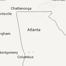
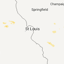
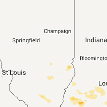
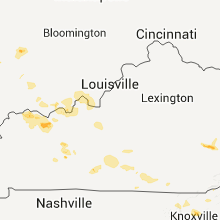
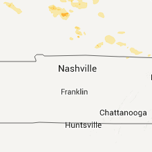
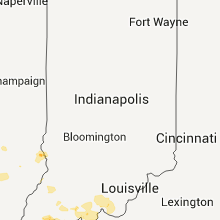
Hail Map for Sunday, June 21, 2015

Number of Impacted Households on 6/21/2015
0
Impacted by 1" or Larger Hail
0
Impacted by 1.75" or Larger Hail
0
Impacted by 2.5" or Larger Hail
Square Miles of Populated Area Impacted on 6/21/2015
0
Impacted by 1" or Larger Hail
0
Impacted by 1.75" or Larger Hail
0
Impacted by 2.5" or Larger Hail


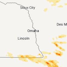


Cities Most Affected by Hail Storms of 6/21/2015
| Hail Size | Demographics of Zip Codes Affected | ||||||
|---|---|---|---|---|---|---|---|
| City | Count | Average | Largest | Pop Density | House Value | Income | Age |
| Sutherland, NE | 7 | 3.68 | 4.25 | 3 | $74k | $38.9k | 40.6 |
| Ismay, MT | 3 | 2.33 | 2.75 | 0 | $85k | $30.2k | 45.7 |
| De Kalb, MO | 2 | 3.50 | 4.25 | 16 | $70k | $43.3k | 40.3 |
| Dickens, NE | 2 | 3.38 | 4.25 | 1 | $95k | $50.4k | 38.5 |
| Paxton, NE | 3 | 2.25 | 2.50 | 2 | $55k | $30.8k | 43.4 |
| Meadow, SD | 2 | 2.38 | 2.75 | 0 | $31k | $19.7k | 43.8 |
| Arthur, NE | 2 | 2.13 | 2.50 | 0 | $48k | $30.5k | 43.8 |
| Bremen, KS | 2 | 1.75 | 1.75 | 5 | $53k | $33.1k | 45.7 |
| Terry, MT | 1 | 2.50 | 2.50 | 0 | $36k | $26.3k | 55.3 |
| Marysville, KS | 1 | 2.00 | 2.00 | 20 | $60k | $33.8k | 44.0 |
| Pattonsburg, MO | 1 | 2.00 | 2.00 | 7 | $57k | $31.5k | 41.7 |
| Aberdeen, SD | 1 | 1.75 | 1.75 | 103 | $76k | $34.7k | 37.6 |
| Baker, MT | 1 | 1.75 | 1.75 | 0 | $49k | $30.7k | 42.1 |
| Mc Cook, NE | 1 | 1.75 | 1.75 | 21 | $63k | $32.2k | 40.9 |
| Wallace, NE | 1 | 1.75 | 1.75 | 1 | $55k | $36.5k | 42.3 |
| Powhattan, KS | 1 | 1.75 | 1.75 | 4 | $35k | $31.0k | 37.8 |
| Bath, SD | 1 | 1.75 | 1.75 | 9 | $88k | $38.0k | 38.2 |
| Smithville, MO | 1 | 1.75 | 1.75 | 183 | $126k | $58.3k | 39.2 |
Hail and Wind Damage Spotted on 6/21/2015
Filter by Report Type:Hail ReportsWind Reports
States Impacted
Nebraska, Missouri, Kansas, Montana, Kentucky, Georgia, West Virginia, Virginia, New Jersey, Pennsylvania, Mississippi, Florida, New York, Illinois, Arkansas, North Carolina, Tennessee, North Dakota, Iowa, New Mexico, Indiana, South Dakota, MinnesotaNebraska
| Local Time | Report Details |
|---|---|
| 6:10 AM MDT | Tennis Ball sized hail reported near Arthur, NE, 59 miles NW of North Platte, NE, window broken...screens knocked out...car damage |
| 6:15 AM MDT | Golf Ball sized hail reported near Arthur, NE, 56.7 miles WNW of North Platte, NE, ping pong to golf ball size hail for 2 to 3 minutes |
| 6:45 AM MDT | Grapefruit sized hail reported near Sutherland, NE, 26.7 miles W of North Platte, NE, hail up to the size of softballs knocked out all windows on the north side of the house and most windows of the vehicles on the property. |
| 8:00 AM CDT | Golf Ball sized hail reported near Sutherland, NE, 26 miles W of North Platte, NE |
| 7:03 AM MDT | Tennis Ball sized hail reported near Paxton, NE, 28 miles W of North Platte, NE |
| 7:04 AM MDT | Golf Ball sized hail reported near Paxton, NE, 28.1 miles W of North Platte, NE |
| 7:04 AM MDT | Tennis Ball sized hail reported near Paxton, NE, 28 miles W of North Platte, NE |
| 8:10 AM CDT | Grapefruit sized hail reported near Sutherland, NE, 21.8 miles W of North Platte, NE |
| 8:15 AM CDT | Grapefruit sized hail reported near Dickens, NE, 17.4 miles SW of North Platte, NE, large hail put holes in roof and living room ceiling. all vehicles on property have significant damage. |
| 8:15 AM CDT | Grapefruit sized hail reported near Sutherland, NE, 25.2 miles W of North Platte, NE, window broken and truck windshield broken |
| 8:20 AM CDT | Baseball sized hail reported near Sutherland, NE, 24.7 miles WSW of North Platte, NE, time estimated by radar. relayed via social media |
| 8:25 AM CDT | Grapefruit sized hail reported near Sutherland, NE, 24.1 miles W of North Platte, NE, all windows on west side of house broken out. roof damage and leaks in a few places. car damage windows broken and dents |
| 8:35 AM CDT | Golf Ball sized hail reported near Wallace, NE, 24.4 miles WSW of North Platte, NE, crop damage to corn and alfalfa. dent damage to vehicles. |
| 8:35 AM CDT | Tennis Ball sized hail reported near Dickens, NE, 24.2 miles SSW of North Platte, NE, time estimated by radar |
| 7:45 AM MDT | Grapefruit sized hail reported near Sutherland, NE, 26.7 miles W of North Platte, NE, hail up to the size of softballs knocked out all windows on the north side of the house and most windows of the vehicles on the property. |
| 9:07 AM CDT | Ping Pong Ball sized hail reported near Hayes Center, NE, 44.8 miles S of North Platte, NE |
| 9:14 AM CDT | Quarter sized hail reported near Maywood, NE, 40.5 miles S of North Platte, NE |
| 9:30 AM CDT | Golf Ball sized hail reported near Mc Cook, NE, 48.8 miles S of North Platte, NE, delayed report of golf ball size hail at red willow reservoir state recreation headquarters |
| 9:50 AM CDT | Quarter sized hail reported near Indianola, NE, 64.8 miles SSE of North Platte, NE, time estimated from radar. |
Missouri
| Local Time | Report Details |
|---|---|
| 9:00 AM CDT | Golf Ball sized hail reported near Smithville, MO, 19.8 miles N of Kansas City, MO |
| 9:39 AM CDT | Quarter sized hail reported near Excelsior Springs, MO, 25 miles NE of Kansas City, MO |
| 11:25 AM CDT | Quarter sized hail reported near Kearney, MO, 19.1 miles NNE of Kansas City, MO |
| 12:00 PM CDT | Power lines blown down in the city of richmond. time estimated from rada in ray county MO, 35.1 miles ENE of Kansas City, MO |
| 12:05 PM CDT | Trees uprooted near henrietta. time and location estimated from rada in ray county MO, 35.3 miles ENE of Kansas City, MO |
| 12:45 PM CDT | Estimated between 50 and 60 mph. relayed through county e in buchanan county MO, 38.4 miles NNW of Kansas City, MO |
| 12:45 PM CDT | Grapefruit sized hail reported near De Kalb, MO, 38.4 miles NNW of Kansas City, MO, relayed through the county em. |
| 12:48 PM CDT | Quarter sized hail reported near Faucett, MO, 37.4 miles NNW of Kansas City, MO |
| 1:02 PM CDT | Baseball sized hail reported near De Kalb, MO, 38.4 miles NNW of Kansas City, MO, 35 to 40 mph winds. |
| 1:14 PM CDT | 3 power poles down at the intersection of hwy 92 and north winan road. crops lying flat in adjacent field in platte county MO, 18 miles NNW of Kansas City, MO |
| 1:20 PM CDT | Power out at kansas city international airpor in platte county MO, 15.4 miles NNW of Kansas City, MO |
| 1:39 PM CDT | Estimated 60 to 65 mph. also torrential rai in clay county MO, 15.7 miles N of Kansas City, MO |
| 2:30 PM CDT | Quarter sized hail reported near Saint Joseph, MO, 47.3 miles NNW of Kansas City, MO, this might be a duplicate report. report from twitter. |
| 2:39 PM CDT | Quarter sized hail reported near Saint Joseph, MO, 46.9 miles NNW of Kansas City, MO, location estimated from radar. report via social media. |
| 3:38 PM CDT | Storm damage reported in clinton county MO, 31 miles NNE of Kansas City, MO |
| 3:43 PM CDT | Quarter sized hail reported near Holt, MO, 27.3 miles NNE of Kansas City, MO |
| 3:45 PM CDT | Quarter sized hail reported near Holt, MO, 25.3 miles NNE of Kansas City, MO |
| 4:54 PM CDT | Quarter sized hail reported near Mc Fall, MO, 72.1 miles NNE of Kansas City, MO |
| 5:04 PM CDT | Hen Egg sized hail reported near Pattonsburg, MO, 69.5 miles NNE of Kansas City, MO |
| 5:11 PM CDT | Quarter sized hail reported near Pattonsburg, MO, 69.5 miles NNE of Kansas City, MO |
| 5:14 PM CDT | Quarter sized hail reported near Pattonsburg, MO, 69.5 miles NNE of Kansas City, MO |
| 5:20 PM CDT | Quarter sized hail reported near Bethany, MO, 86.2 miles NNE of Kansas City, MO |
| 5:37 PM CDT | Quarter sized hail reported near Ridgeway, MO, 85.2 miles SSW of Des Moines, IA |
| 5:37 PM CDT | Tree uprooted in harrison county MO, 85.7 miles NNE of Kansas City, MO |
| 5:40 PM CDT | Quarter sized hail reported near Coffey, MO, 76.8 miles NNE of Kansas City, MO |
| 5:50 PM CDT | Quarter sized hail reported near Gilman City, MO, 81.5 miles NNE of Kansas City, MO |
| 6:30 PM CDT | Quarter sized hail reported near Eagleville, MO, 79.7 miles SSW of Des Moines, IA |
Kansas
| Local Time | Report Details |
|---|---|
| 11:04 AM CDT | Golf Ball sized hail reported near Bremen, KS, 51.2 miles NNW of Manhattan, KS, relayed from public |
| 11:13 AM CDT | Hen Egg sized hail reported near Marysville, KS, 55.3 miles N of Manhattan, KS |
| 11:17 AM CDT | Golf Ball sized hail reported near Bremen, KS, 51.2 miles NNW of Manhattan, KS |
| 11:20 AM CDT | Quarter sized hail reported near Marysville, KS, 54.1 miles N of Manhattan, KS, hail mixed with heavy rainfall. |
| 11:28 AM CDT | Quarter sized hail reported near Bremen, KS, 50.4 miles NNW of Manhattan, KS |
| 11:37 AM CDT | Quarter sized hail reported near Marysville, KS, 47.4 miles N of Manhattan, KS, pea to quarter sized hail mix along with heavy rain. |
| 11:40 AM CDT | Quarter sized hail reported near Marysville, KS, 45.9 miles N of Manhattan, KS |
| 11:57 AM CDT | Quarter sized hail reported near Marysville, KS, 46.2 miles N of Manhattan, KS |
| 1:54 PM CDT | Golf Ball sized hail reported near Powhattan, KS, 59.7 miles NE of Manhattan, KS |
Montana
| Local Time | Report Details |
|---|---|
| 1:20 PM MDT | Quarter sized hail reported near Plentywood, MT, 61.1 miles NW of Williston, ND, estimated quarter sized hail. 0.60 inches of precip in 25 minutues |
| 1:20 PM MDT | Quarter sized hail reported near Plentywood, MT, 61.4 miles NW of Williston, ND, estimated quarter sized / 1 inch hail. |
| 3:35 PM MDT | Tennis Ball sized hail reported near Terry, MT, 37.5 miles ENE of Miles City, MT, estimated tennis ball sized hail 2 1/2 inches. |
| 3:45 PM MDT | Golf Ball sized hail reported near Ismay, MT, 44.8 miles E of Miles City, MT, spotter reported hail up to the size of golf balls. with windows knocked out of house. |
| 3:50 PM MDT | Half Dollar sized hail reported near Wibaux, MT, 84.7 miles SSW of Williston, ND, estimated 1 1/4 inch hail. heavy rain. |
| 3:55 PM MDT | Baseball sized hail reported near Ismay, MT, 42.5 miles E of Miles City, MT, spotter reported baseball hail that destroyed their windshield and wind gust of 70 mph. |
| 4:00 PM MDT | Tennis Ball sized hail reported near Ismay, MT, 47.7 miles E of Miles City, MT, golf ball to tennis ball sized hail 3 to 4 inch deep along road. trees completely bare...like winter time. roadside reflectors shattered all along hwy 12 mm55. |
| 4:40 PM MDT | Golf Ball sized hail reported near Baker, MT, 72.6 miles E of Miles City, MT, spotter reported golfball hail. |
| 7:35 PM MDT | Storm damage reported in rosebud county MT, 40.4 miles WSW of Miles City, MT |
| 8:02 PM MDT | Pull camper blown over at mile marker 13 in custer county MT, 5.2 miles SW of Miles City, MT |
| 8:10 PM MDT | Storm damage reported in custer county MT, 2.5 miles NW of Miles City, MT |
| 8:10 PM MDT | Pea hail and 60 mph winds and heavy rai in custer county MT, 9.1 miles SSE of Miles City, MT |
| 8:14 PM MDT | Storm damage reported in custer county MT, 2.5 miles NW of Miles City, MT |
| 8:29 PM MDT | Pull camper blown over at mile marker 13 in custer county MT, 5.2 miles SW of Miles City, MT |
| 8:40 PM MDT | Quarter sized hail reported near Miles City, MT, 30 miles ESE of Miles City, MT, spotter reported 60 mph winds and hail up to the size of quarters. |
| 8:40 PM MDT | Spotter reported 60 mph winds and hail up to the size of quarter in custer county MT, 30 miles ESE of Miles City, MT |
| 8:40 PM MDT | Observer reported high winds and pea hail. roof on house is leakin in custer county MT, 27.9 miles ESE of Miles City, MT |
| 9:39 PM MDT | Storm damage reported in fallon county MT, 76.1 miles E of Miles City, MT |
Kentucky
| Local Time | Report Details |
|---|---|
| 2:56 PM CDT | Recorded at hart county mesonet in hart county KY, 50.3 miles S of Louisville, KY |
| 4:05 PM EDT | Tree down on highway 8 in leslie county KY, 50.8 miles SE of Irvine, KY |
| 4:15 PM EDT | Tree down in whitesbur in letcher county KY, 49.6 miles NW of Bristol, TN |
| 4:01 PM CDT | Quarter sized hail reported near Morgantown, KY, 70.8 miles SE of Evansville, IN |
| 5:03 PM EDT | A tree was reported to have been blown dow in bell county KY, 46.2 miles NNE of Knoxville, TN |
| 4:25 PM CDT | Quarter sized hail reported near Scottsville, KY, 61.3 miles NNE of Nashville, TN, reported near barren river dam. |
| 5:43 PM EDT | Large limbs were blown dow in wayne county KY, 76.4 miles SW of Irvine, KY |
| 5:45 PM EDT | A tree was blown down on hwy 834 east just off hwy 9 in wayne county KY, 80.9 miles NW of Knoxville, TN |
| 5:50 PM EDT | Large limbs were blown dow in wayne county KY, 76.4 miles SW of Irvine, KY |
| 4:57 PM CDT | Quarter sized hail reported near Scottsville, KY, 61.3 miles NNE of Nashville, TN, reported near barren river dam. corrected for the time. |
| 4:57 PM CDT | Trees down near the barren river da in allen county KY, 61.3 miles NNE of Nashville, TN |
| 6:25 PM EDT | Trees were blown down and part of a metal roof was blown off of a structur in mccreary county KY, 59.2 miles NNW of Knoxville, TN |
| 8:23 PM CDT | Quarter sized hail reported near Henderson, KY, 9.5 miles S of Evansville, IN, multiple reports of quarter size hail on the north side of town. |
| 9:22 PM CDT | Large tree down. picture via twitte in ohio county KY, 51.8 miles SE of Evansville, IN |
| 11:08 PM CDT | Several trees and power lines down on crenshaw cassady rd and cave ridge - new liberty r in metcalfe county KY, 64 miles S of Louisville, KY |
Georgia
| Local Time | Report Details |
|---|---|
| 4:17 PM EDT | 911 center received report of two trees down along highway 67 just east of toombbor in wilkinson county GA, 78.1 miles SW of Augusta, GA |
West Virginia
| Local Time | Report Details |
|---|---|
| 4:34 PM EDT | Quarter sized hail reported near Matoaka, WV, 67.6 miles SSE of Charleston, WV, dime to quarter size hail in the rock area. |
| 6:07 PM EDT | Quarter sized hail reported near Gassaway, WV, 51.7 miles WSW of Elkins, WV, pea to quarter size hail. very heavy rainfall with 1/3 in 10 minutes. |
Virginia
| Local Time | Report Details |
|---|---|
| 4:43 PM EDT | Tree down on givens lane in giles county VA, 29.9 miles W of Roanoke, VA |
| 4:45 PM EDT | Tree down on clover hollow rd in giles county VA, 29.4 miles W of Roanoke, VA |
| 5:00 PM EDT | Quarter sized hail reported near Bluefield, VA, 62.1 miles NE of Bristol, TN, dime to quarter size hail. winds estimated around 50mph |
| 5:00 PM EDT | Trees and power lines dow in wise county VA, 28.3 miles NNW of Bristol, TN |
| 5:10 PM EDT | 1 tree down in tow in tazewell county VA, 69.5 miles NE of Bristol, TN |
| 5:30 PM EDT | Quarter sized hail reported near Radford, VA, 36.3 miles WSW of Roanoke, VA, dime to quarter size hail west of fairlawn |
| 5:34 PM EDT | One tree down near intersection of naff road... and u.s. highway 22 in franklin county VA, 9.9 miles S of Roanoke, VA |
| 5:45 PM EDT | Quarter sized hail reported near Christiansburg, VA, 27.7 miles WSW of Roanoke, VA |
| 5:49 PM EDT | Tree down virgil h goode hwy and whispering creek rd in franklin county VA, 11.1 miles S of Roanoke, VA |
| 5:50 PM EDT | Several large tree limbs down on boones mill rd in franklin county VA, 10.5 miles S of Roanoke, VA |
| 5:52 PM EDT | Quarter sized hail reported near Boones Mill, VA, 7.7 miles S of Roanoke, VA, dime to quarter size hail north of boones mill |
| 6:00 PM EDT | Tree down on cinnamon run in wythe county VA, 63.4 miles ENE of Bristol, TN |
| 6:01 PM EDT | Tree down at 5477 old franklin tpke in franklin county VA, 20.1 miles SSE of Roanoke, VA |
| 6:05 PM EDT | Quarter sized hail reported near Gate City, VA, 23.5 miles W of Bristol, TN |
| 6:05 PM EDT | Tree down on scratch gravel rd blocking one lane in smyth county VA, 40.5 miles ENE of Bristol, TN |
| 6:05 PM EDT | Multiple trees and power lines down throughout the town in franklin county VA, 18.4 miles SSW of Roanoke, VA |
| 6:05 PM EDT | One tree down near interesection of dillards hill and piney point roa in franklin county VA, 22.9 miles SE of Roanoke, VA |
| 6:05 PM EDT | One tree down along kamp branch roa in franklin county VA, 22 miles SE of Roanoke, VA |
| 6:05 PM EDT | Tree down on power line 515 dove road. time estimated by rada in franklin county VA, 21.8 miles SE of Roanoke, VA |
| 6:06 PM EDT | Tree down 895 piney point lane. time estimated by rada in franklin county VA, 22.4 miles SE of Roanoke, VA |
| 6:06 PM EDT | One tree down at intersection of kemp ford road and balsam driv in franklin county VA, 21.6 miles SE of Roanoke, VA |
| 6:08 PM EDT | Tree down dillards hill rd and piney point rd in franklin county VA, 22.5 miles SE of Roanoke, VA |
| 6:08 PM EDT | Tree down 3400 five mile mountain rd. time estimated by radar in franklin county VA, 22.2 miles SSW of Roanoke, VA |
| 6:08 PM EDT | Multiple trees down in the union hall area in franklin county VA, 21.3 miles SE of Roanoke, VA |
| 6:10 PM EDT | Multiple trees and power lines down around town in franklin county VA, 26.4 miles SE of Roanoke, VA |
| 6:10 PM EDT | Multiple trees down around town in franklin county VA, 13.4 miles S of Roanoke, VA |
| 6:13 PM EDT | One tree down on watters edge driv in franklin county VA, 25.2 miles SE of Roanoke, VA |
| 6:15 PM EDT | One tree down at intersection of old forge and old ferrum roa in franklin county VA, 22.2 miles S of Roanoke, VA |
| 6:15 PM EDT | Multiple trees down on burnt chimney rd in franklin county VA, 16.3 miles SE of Roanoke, VA |
| 6:21 PM EDT | Tree and power line down near fishburn mountain and briar mountain roa in franklin county VA, 24.4 miles S of Roanoke, VA |
| 6:25 PM EDT | Tree down virgil h goode hwy and glen dr. time estimated by radar in franklin county VA, 25.9 miles S of Roanoke, VA |
| 6:25 PM EDT | Power line down 2402 booker t washington hwy. time estimated by rada in franklin county VA, 16.9 miles SSE of Roanoke, VA |
| 6:25 PM EDT | Tree down 3547 booker t washington hwy in franklin county VA, 15.6 miles SSE of Roanoke, VA |
| 6:40 PM EDT | One tree down along truevine roa in franklin county VA, 30.6 miles SSE of Roanoke, VA |
| 6:45 PM EDT | Multiple trees down from the hurt area west to near smith mountain lak in pittsylvania county VA, 38.8 miles ESE of Roanoke, VA |
| 8:41 PM EDT | Tree down on old dominion and spring hill drive in city of alexandria county VA, 41.5 miles SW of Baltimore, MD |
New Jersey
| Local Time | Report Details |
|---|---|
| 5:00 PM EDT | Power lines blown down. time estimated from rada in sussex county NJ, 47.8 miles ESE of Scranton, PA |
| 5:50 PM EDT | Trees down at diamond bridge avenue in passaic county NJ, 20.5 miles NNW of Brooklyn, NY |
Pennsylvania
| Local Time | Report Details |
|---|---|
| 5:07 PM EDT | Trees down at 200 portersville r in lawrence county PA, 32.4 miles NNW of Pittsburgh, PA |
Mississippi
| Local Time | Report Details |
|---|---|
| 4:28 PM CDT | Tree and powerline down at the intersection of highway 42 and highway 6 in greene county MS, 62 miles NW of Mobile, AL |
Florida
| Local Time | Report Details |
|---|---|
| 5:40 PM EDT | The sheriffs office received reports of trees down near interstate 10 and 185th road in falmouth. the time was based on rada in suwannee county FL, 68.9 miles E of Tallahassee, FL |
| 6:05 PM EDT | Trained spotter reports a large tree downed by strong wind gusts along southeast 69th terrace near the belleview sports complex. time of damage based on radar dat in marion county FL, 54.4 miles NW of Orlando, FL |
| 6:15 PM EDT | Several reports of power lines blown down by thunderstorm winds near silver spring shore in marion county FL, 54.4 miles NW of Orlando, FL |
| 6:55 PM EDT | Trained spotter near belleview reports estimated 60-70 mph winds from a severe thunderstorm that bent an antenna. time of damage based on radar dat in marion county FL, 54.4 miles NW of Orlando, FL |
| 6:55 PM EDT | Large tree down on power lines in columbia county FL, 54.3 miles WSW of Jacksonville, FL |
| 6:55 PM EDT | Broadcoast media relayed a newspaper report of significant wind damage with large trees down at the oak tree village apartments and campground. four campers were damage in marion county FL, 67.6 miles NW of Orlando, FL |
New York
| Local Time | Report Details |
|---|---|
| 5:53 PM EDT | Trees down on route 82 caused the road to be closed between lomala road and old hopewell roa in dutchess county NY, 60.3 miles N of Brooklyn, NY |
Illinois
| Local Time | Report Details |
|---|---|
| 5:25 PM CDT | Large tree down with isolated power outages reporte in franklin county IL, 59.6 miles NE of Cape Girardeau, MO |
| 6:10 PM CDT | Small tree limbs down throughout the community with pea size hail reported near the middle schoo in saline county IL, 56.3 miles WSW of Evansville, IN |
| 12:55 AM CDT | Storm damage reported in crawford county IL, 47.1 miles SE of Mattoon, IL |
Arkansas
| Local Time | Report Details |
|---|---|
| 6:16 PM CDT | Storm damage reported in sevier county AR, 29 miles WNW of Nashville, AR |
| 6:20 PM CDT | Trees down in dogtown area sw of de queen in sevier county AR, 30.9 miles W of Nashville, AR |
| 6:27 PM CDT | Power lines down / power out... old dierks hwy... and geneva church road and farm to market roads southeast of de queen in sevier county AR, 26.4 miles W of Nashville, AR |
| 6:30 PM CDT | Trees down by old 70e and old dierks hwy in sevier county AR, 29 miles WNW of Nashville, AR |
| 6:35 PM CDT | Tree down in alleene in little river county AR, 23.4 miles WSW of Nashville, AR |
| 7:04 PM CDT | Tree down on mt. pleasant street in howard county AR, 0.6 miles SSW of Nashville, AR |
North Carolina
| Local Time | Report Details |
|---|---|
| 7:25 PM EDT | Tree down in fletcher in henderson county NC, 41.7 miles N of Greenville, SC |
| 7:25 PM EDT | Asheville 911 reports trees and powerlines down on fair oaks rd in arde in buncombe county NC, 43 miles N of Greenville, SC |
| 7:35 PM EDT | Quarter sized hail reported near Hendersonville, NC, 37.9 miles N of Greenville, SC, quarter-sized hail reported off of i26 at rest area north of hendersonville |
| 8:20 PM EDT | One tree dow in rockingham county NC, 65.3 miles SSE of Roanoke, VA |
Tennessee
| Local Time | Report Details |
|---|---|
| 7:40 PM EDT | Several trees down across union co...especially around the paulette area in union county TN, 15.9 miles N of Knoxville, TN |
| 7:40 PM EDT | Trees and power lines down over northern part of county in knox county TN, 11.3 miles NE of Knoxville, TN |
| 8:42 PM EDT | Several trees down across grainger county in grainger county TN, 31 miles NE of Knoxville, TN |
North Dakota
| Local Time | Report Details |
|---|---|
| 6:00 PM MDT | Quarter sized hail reported near Rhame, ND, 107.6 miles ESE of Miles City, MT, hail began at 650 pm cdt and is ongoing at time of call |
| 6:20 PM MDT | Quarter sized hail reported near Bowman, ND, 112.8 miles ESE of Miles City, MT, lasted 5 minutes |
| 8:00 PM CDT | Nickel size hail also reporte in morton county ND, 30.1 miles W of Bismarck, ND |
| 8:05 PM CDT | Estm. 80 to 90 mph...large tree limbs down. heavy rain caused street and rural flooding. several car accident in morton county ND, 30.1 miles W of Bismarck, ND |
| 8:31 PM CDT | Pea size hail in morton county ND, 21.4 miles W of Bismarck, ND |
| 7:55 PM MDT | Ping Pong Ball sized hail reported near Mott, ND, 82.7 miles WSW of Bismarck, ND, hail fell at approximately 732 pm mdt |
| 9:05 PM CDT | Storm damage reported in morton county ND, 11.8 miles SSW of Bismarck, ND |
| 10:00 PM CDT | Storm damage reported in foster county ND, 47.7 miles SSW of Devils Lake, ND |
| 10:05 PM CDT | Storm damage reported in emmons county ND, 45.3 miles SE of Bismarck, ND |
| 10:05 PM CDT | Quarter sized hail reported near Linton, ND, 45.3 miles SE of Bismarck, ND |
| 10:10 PM CDT | Quarter sized hail reported near Linton, ND, 42.5 miles SE of Bismarck, ND |
| 10:10 PM CDT | Storm damage reported in emmons county ND, 47.7 miles SSE of Bismarck, ND |
| 10:13 PM CDT | Storm damage reported in foster county ND, 47.7 miles SSW of Devils Lake, ND |
| 10:35 PM CDT | Power lines down north of zeeland in mcintosh county ND, 71.2 miles SE of Bismarck, ND |
| 10:44 PM CDT | Storm damage reported in mcintosh county ND, 66 miles SE of Bismarck, ND |
| 10:06 PM MDT | Reported 60 to 70 mph gusts in bowman county ND, 94.1 miles E of Miles City, MT |
| 10:09 PM MDT | Storm damage reported in bowman county ND, 93.8 miles E of Miles City, MT |
| 10:28 PM MDT | Dime sized hail also occurre in adams county ND, 104.9 miles WSW of Bismarck, ND |
Iowa
| Local Time | Report Details |
|---|---|
| 7:10 PM CDT | Half Dollar sized hail reported near Redding, IA, 76 miles SSW of Des Moines, IA |
| 7:16 PM CDT | Quarter sized hail reported near Decatur, IA, 61.3 miles SSW of Des Moines, IA, time of hail estimated using radar. |
| 4:30 AM CDT | Quarter sized hail reported near Urbana, IA, 19.9 miles NNW of Cedar Rapids, IA, one hailstone measured just over 1 inch. rest were dime size and smaller. |
| 5:20 AM CDT | Storm damage reported in lyon county IA, 39.2 miles ESE of Sioux Falls, SD |
| 5:37 AM CDT | Awos peak of 95 mph. hangar at airport destroyed...damage to planes. em reporting other damage in north side of sheldon in o'brien county IA, 50.5 miles ESE of Sioux Falls, SD |
| 5:48 AM CDT | Storm damage reported in osceola county IA, 55.2 miles NNW of Storm Lake, IA |
| 5:50 AM CDT | Quarter sized hail reported near Woden, IA, 36.6 miles WNW of Mason City, IA, nickel to quarter size hail reported 2 miles north of woden. report via social media |
| 5:55 AM CDT | 2 foot diameter trees snapped in cherokee county IA, 33.4 miles WNW of Storm Lake, IA |
| 6:00 AM CDT | Mesonet station 3 sse lake park /as497/ in dickinson county IA, 52.2 miles N of Storm Lake, IA |
| 6:07 AM CDT | Quarter sized hail reported near Forest City, IA, 23.5 miles WNW of Mason City, IA, quarter size hail reported at sheriff's office. report via social media |
| 6:09 AM CDT | Law enforcement reported one foot diameter tree snapped in half in cherokee county IA, 28.2 miles WNW of Storm Lake, IA |
| 6:16 AM CDT | Trees reported down in estherville and sw of town. winds estimated to be greater than 50 mp in emmet county IA, 51.7 miles NNE of Storm Lake, IA |
| 6:19 AM CDT | Estherville asos at estherville municipal airport measured 59 mph wind gust at 6:19 a in emmet county IA, 56.8 miles NNE of Storm Lake, IA |
| 6:34 AM CDT | Quarter sized hail reported near Elkader, IA, 62.6 miles NNE of Cedar Rapids, IA |
| 6:46 AM CDT | Power poles down in the city. winds estimated up to 60 mph. some minor flooding occurring in a low spot in the cit in kossuth county IA, 52.3 miles W of Mason City, IA |
| 6:48 AM CDT | Half Dollar sized hail reported near Cresco, IA, 52.8 miles SW of La Crosse, WI |
New Mexico
| Local Time | Report Details |
|---|---|
| 6:15 PM MDT | Winds estimated in excess of 50 mph. three large trees down on nmsu campus at married housing units in dona ana county NM, 41.5 miles NNW of El Paso, TX |
Indiana
| Local Time | Report Details |
|---|---|
| 9:26 PM EDT | A tree on a power line in crawford county IN, 39 miles WNW of Louisville, KY |
South Dakota
| Local Time | Report Details |
|---|---|
| 8:13 PM MDT | Hen Egg sized hail reported near Meadow, SD, 109.7 miles SW of Bismarck, ND |
| 8:15 PM MDT | Baseball sized hail reported near Meadow, SD, 110 miles NNE of Rapid City, SD, lasted 15 minutes |
| 11:45 PM CDT | Storm damage reported in brown county SD, 32.5 miles N of Aberdeen, SD |
| 11:54 PM CDT | Storm damage reported in brown county SD, 19 miles NNW of Aberdeen, SD |
| 12:00 AM CDT | Quarter sized hail reported near Aberdeen, SD, 8.2 miles NW of Aberdeen, SD |
| 12:10 AM CDT | Golf Ball sized hail reported near Aberdeen, SD, 5.3 miles NW of Aberdeen, SD |
| 12:11 AM CDT | Quarter sized hail reported near Aberdeen, SD, 0.8 miles NNE of Aberdeen, SD |
| 12:18 AM CDT | Golf Ball sized hail reported near Bath, SD, 8.2 miles E of Aberdeen, SD |
| 12:19 AM CDT | Abr aso in brown county SD, 0.8 miles NNE of Aberdeen, SD |
| 12:08 AM MDT | Storm damage reported in corson county SD, 83.1 miles S of Bismarck, ND |
| 1:10 AM CDT | Quarter sized hail reported near Groton, SD, 22.1 miles ESE of Aberdeen, SD |
| 12:10 AM MDT | Time estimated from radar in pennington county SD, 11.7 miles SW of Rapid City, SD |
| 12:10 AM MDT | Storm damage reported in pennington county SD, 9 miles ESE of Rapid City, SD |
| 12:19 AM MDT | Storm damage reported in pennington county SD, 1.3 miles SE of Rapid City, SD |
| 12:30 AM MDT | Storm damage reported in pennington county SD, 36.9 miles E of Rapid City, SD |
| 12:35 AM MDT | Large trees blown down...small hail lasted 15 min in pennington county SD, 50.3 miles ENE of Rapid City, SD |
| 12:35 AM MDT | Storm damage reported in meade county SD, 41.4 miles ENE of Rapid City, SD |
| 1:45 AM CDT | Storm damage reported in walworth county SD, 81 miles N of Pierre, SD |
| 1:50 AM CDT | Quarter sized hail reported near Webster, SD, 53.8 miles ESE of Aberdeen, SD, power is out |
| 1:51 AM CDT | Quarter sized hail reported near Webster, SD, 47.8 miles E of Aberdeen, SD |
| 1:10 AM MDT | Storm damage reported in jackson county SD, 68.2 miles E of Rapid City, SD |
| 1:15 AM MDT | Storm damage reported in haakon county SD, 44.9 miles W of Pierre, SD |
| 2:30 AM CDT | Sdsu site in brule county SD, 63.5 miles SE of Pierre, SD |
| 1:30 AM MDT | At least 80 mph winds...shingle damage and siding damage in stanley county SD, 27.2 miles W of Pierre, SD |
| 1:32 AM MDT | Storm damage reported in stanley county SD, 33.2 miles W of Pierre, SD |
| 2:50 AM CDT | Storm damage reported in lyman county SD, 17.4 miles S of Pierre, SD |
| 3:05 AM CDT | Storm damage reported in hughes county SD, 17.4 miles E of Pierre, SD |
| 3:09 AM CDT | Storm damage reported in lyman county SD, 38 miles SE of Pierre, SD |
| 3:45 AM CDT | Storm damage reported in hand county SD, 79.3 miles E of Pierre, SD |
| 4:10 AM CDT | Sdsu site in hutchinson county SD, 64.3 miles W of Sioux Falls, SD |
| 4:48 AM CDT | Car mounted anemometer in minnehaha county SD, 5.5 miles W of Sioux Falls, SD |
| 4:56 AM CDT | Storm damage reported in minnehaha county SD, 2.4 miles N of Sioux Falls, SD |
| 4:59 AM CDT | Storm damage reported in minnehaha county SD, 5.6 miles E of Sioux Falls, SD |
| 5:00 AM CDT | Co-op observer station baltic /btcs2/ in minnehaha county SD, 13 miles NNE of Sioux Falls, SD |
| 5:01 AM CDT | 10 in diameter tree down in minnehaha county SD, 17.1 miles NE of Sioux Falls, SD |
Minnesota
| Local Time | Report Details |
|---|---|
| 2:00 AM CDT | Strong wind gust tipped over a semi truck and caused damage to casino buildin in mahnomen county MN, 48.6 miles NE of Fargo, ND |
| 5:30 AM CDT | Quarter sized hail reported near New Richland, MN, 53.3 miles NNW of Mason City, IA |
| 5:56 AM CDT | Storm damage reported in cottonwood county MN, 78 miles SSE of Montevideo, MN |
| 6:02 AM CDT | Storm damage reported in cottonwood county MN, 80 miles SSE of Montevideo, MN |
| 6:07 AM CDT | Emergency manager reported estimated winds of 50-60 mp in cottonwood county MN, 84 miles SSE of Montevideo, MN |
Connect with Interactive Hail Maps