

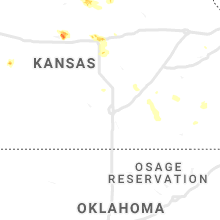
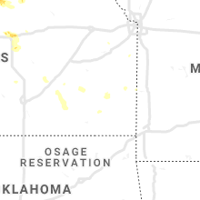
Hail Map for Tuesday, June 25, 2019

Number of Impacted Households on 6/25/2019
0
Impacted by 1" or Larger Hail
0
Impacted by 1.75" or Larger Hail
0
Impacted by 2.5" or Larger Hail
Square Miles of Populated Area Impacted on 6/25/2019
0
Impacted by 1" or Larger Hail
0
Impacted by 1.75" or Larger Hail
0
Impacted by 2.5" or Larger Hail


Cities Most Affected by Hail Storms of 6/25/2019
| Hail Size | Demographics of Zip Codes Affected | ||||||
|---|---|---|---|---|---|---|---|
| City | Count | Average | Largest | Pop Density | House Value | Income | Age |
| Holstein, NE | 4 | 2.50 | 3.00 | 3 | $44k | $42.2k | 40.8 |
| Murray, IA | 2 | 1.88 | 2.00 | 12 | $50k | $32.9k | 39.5 |
| Formoso, KS | 2 | 1.75 | 1.75 | 2 | $10k | $27.3k | 54.5 |
| Peru, NE | 2 | 1.75 | 1.75 | 8 | $39k | $27.3k | 21.8 |
| Kenesaw, NE | 1 | 2.50 | 2.50 | 6 | $69k | $38.9k | 40.7 |
| Shickley, NE | 1 | 2.00 | 2.00 | 3 | $61k | $43.5k | 50.2 |
| Superior, NE | 1 | 1.75 | 1.75 | 16 | $36k | $26.9k | 51.0 |
| Naponee, NE | 1 | 1.75 | 1.75 | 3 | $18k | $30.6k | 50.8 |
| Lucas, KS | 1 | 1.75 | 1.75 | 2 | $26k | $31.1k | 51.2 |
| Juniata, NE | 1 | 1.75 | 1.75 | 17 | $92k | $38.4k | 40.0 |
| Plano, IA | 1 | 1.75 | 1.75 | 8 | $58k | $31.6k | 54.3 |
| Centerville, IA | 1 | 1.75 | 1.75 | 59 | $48k | $28.5k | 43.1 |
| Lodge Grass, MT | 1 | 1.75 | 1.75 | 0 | $48k | $23.3k | 27.7 |
| Watson, MO | 1 | 1.75 | 1.75 | 4 | $33k | $26.3k | 40.0 |
| Carthage, IL | 1 | 1.75 | 1.75 | 24 | $63k | $36.8k | 44.1 |
| Aladdin, WY | 1 | 1.75 | 1.75 | 1 | $189k | $15.0k | 55.4 |
| Sylvan Grove, KS | 1 | 1.75 | 1.75 | 3 | $37k | $28.9k | 48.4 |
| Campbell, NE | 1 | 1.75 | 1.75 | 2 | $22k | $25.8k | 48.7 |
| Ong, NE | 1 | 1.75 | 1.75 | 2 | $10k | $34.4k | 51.2 |
| Panhandle, TX | 1 | 1.75 | 1.75 | 1 | $58k | $41.5k | 39.8 |
| Prescott, IA | 1 | 1.75 | 1.75 | 6 | $23k | $35.2k | 46.5 |
Hail and Wind Damage Spotted on 6/25/2019
Filter by Report Type:Hail ReportsWind Reports
States Impacted
Texas, Kansas, Florida, Nebraska, Louisiana, Alabama, Illinois, Wyoming, Iowa, Arkansas, Montana, Michigan, Mississippi, Indiana, MissouriTexas
| Local Time | Report Details |
|---|---|
| 7:27 AM CDT | Uscg reported this gust from a local mariner repor in gmz335 county TX, 31.6 miles ESE of Houston, TX |
| 7:30 AM CDT | Measured at weatherflow site xga in gmz335 county TX, 31.6 miles ESE of Houston, TX |
| 4:01 PM CDT | Quarter sized hail reported near Panhandle, TX, 25.4 miles ENE of Amarillo, TX |
| 4:09 PM CDT | Quarter sized hail reported near Panhandle, TX, 27.5 miles ENE of Amarillo, TX, facebook report of quarter size hail in panhandle. |
| 4:14 PM CDT | Quarter sized hail reported near Panhandle, TX, 27.2 miles ENE of Amarillo, TX, accumulating hail up to the size of quarters. |
| 4:38 PM CDT | Golf Ball sized hail reported near Panhandle, TX, 28.3 miles ENE of Amarillo, TX |
| 5:46 PM CDT | Quarter sized hail reported near Gruver, TX, 76.4 miles NNE of Amarillo, TX |
| 7:14 PM CDT | Sustained wind was 47 mph from the north-northwes in hall county TX, 37.4 miles WNW of Childress, TX |
| 9:40 PM CDT | Half Dollar sized hail reported near Amarillo, TX, 5.8 miles N of Amarillo, TX, sporadic half dollar size hail reported at kfda studio. |
| 9:45 PM CDT | Ping Pong Ball sized hail reported near Amarillo, TX, 7.1 miles N of Amarillo, TX |
Kansas
| Local Time | Report Details |
|---|---|
| 7:43 AM CDT | Quarter sized hail reported near Liberal, KS, 64.3 miles S of Garden City, KS |
| 6:29 PM CDT | Quarter sized hail reported near Rolla, KS, 78.2 miles SSW of Garden City, KS, nickel to quarter hail. |
| 7:39 PM CDT | Corrected for additional information. peak measured gust was 66 mph... but gusts were at least 70 mp in jewell county KS, 80.4 miles SSE of Grand Island, NE |
| 7:46 PM CDT | Ping Pong Ball sized hail reported near Formoso, KS, 80.4 miles SSE of Grand Island, NE, spotter network report. |
| 7:47 PM CDT | Golf Ball sized hail reported near Formoso, KS, 81.1 miles SSE of Grand Island, NE |
| 7:50 PM CDT | Quarter sized hail reported near Webber, KS, 70.1 miles SSE of Grand Island, NE |
| 12:50 AM UTC | Pws station kksranda in jewell county KS, 85.8 miles WNW of Manhattan, KS |
| 12:50 AM UTC | Spotter was driving on highway 36 and confident that he experienced 60 mph wind gusts as the storm was passing ove in republic county KS, 80.6 miles SSE of Grand Island, NE |
| 7:56 PM CDT | Golf Ball sized hail reported near Formoso, KS, 81.1 miles SSE of Grand Island, NE, corrects time of the 7:47 pm hail report from formoso. more information was gathered via twitter. |
| 1:40 AM UTC | Spotter confident in 60 mph wind in cloud county KS, 55.6 miles WNW of Manhattan, KS |
| 8:53 PM CDT | Half Dollar sized hail reported near Jamestown, KS, 73.9 miles WNW of Manhattan, KS |
| 3:30 AM UTC | Golf Ball sized hail reported near Lucas, KS, 47.4 miles ENE of Hays, KS |
| 12:08 AM CDT | Golf Ball sized hail reported near Sylvan Grove, KS, 50.2 miles E of Hays, KS |
Florida
| Local Time | Report Details |
|---|---|
| 5:00 PM EDT | Widespread tree and power line in crawfordville... f in wakulla county FL, 18.7 miles SSW of Tallahassee, FL |
| 4:59 PM CDT | Reports of multiple power lines and trees down in the molino area near highway 95a. reports via social medi in escambia county FL, 42.5 miles E of Mobile, AL |
| 6:31 PM EDT | Gust to 51 knots from the nnw. updated for higher gust than occurred earlie in seminole county FL, 18.6 miles NNE of Orlando, FL |
| 11:05 PM UTC | Numerous reports of trees down on the north side of crestview... fl. reports and pictures via social medi in okaloosa county FL, 30.9 miles NNW of Miramar Beach, FL |
| 7:20 PM EDT | Numerous tree branches down that were two to three inches in diameter. time estimated by rada in osceola county FL, 21.3 miles SW of Orlando, FL |
| 6:37 PM CDT | Awos station kegi duke field (eglin afb) measured a wind gust of 61 mp in okaloosa county FL, 20 miles NNW of Miramar Beach, FL |
| 6:40 PM CDT | Trees down on hwy 10a and jackey rd in ponce de leon are in holmes county FL, 35 miles NE of Miramar Beach, FL |
| 12:05 AM UTC | Tree down on driftwood point roa in walton county FL, 3.9 miles NE of Miramar Beach, FL |
| 8:15 PM EDT | Hardee county em reported that a large oak tree was down on mineral springs road east of zolfo springs. dime size hail was also observed in the are in hardee county FL, 52.7 miles E of Bradenton, FL |
Nebraska
| Local Time | Report Details |
|---|---|
| 4:04 PM CDT | Tennis Ball sized hail reported near Kenesaw, NE, 33.5 miles SW of Grand Island, NE, relayed picture of 2.5 inch hail. time estimated from radar. |
| 4:17 PM CDT | Golf Ball sized hail reported near Ong, NE, 43 miles SE of Grand Island, NE, spotter network report. measured with calipers. |
| 4:28 PM CDT | Half Dollar sized hail reported near Shickley, NE, 44.9 miles SE of Grand Island, NE, photo and report from facebook. |
| 4:30 PM CDT | Tennis Ball sized hail reported near Holstein, NE, 32.9 miles SSW of Grand Island, NE, golf ball to tennis ball size hail reported. |
| 4:34 PM CDT | Ping Pong Ball sized hail reported near Juniata, NE, 29 miles SSW of Grand Island, NE |
| 4:39 PM CDT | Golf Ball sized hail reported near Juniata, NE, 29.6 miles SSW of Grand Island, NE |
| 4:56 PM CDT | Quarter sized hail reported near Juniata, NE, 30 miles SSW of Grand Island, NE |
| 5:07 PM CDT | Golf Ball sized hail reported near Holstein, NE, 35.4 miles SSW of Grand Island, NE, public report via local media. |
| 5:10 PM CDT | Quarter sized hail reported near Glenvil, NE, 33.4 miles S of Grand Island, NE |
| 5:13 PM CDT | Baseball sized hail reported near Holstein, NE, 35.6 miles SSW of Grand Island, NE, hail ranging from golf ball to baseball size. |
| 5:13 PM CDT | Tea Cup sized hail reported near Holstein, NE, 35.4 miles SSW of Grand Island, NE, hail stones up to 3 inches in diameter measured in town approximately 30 mins after it fell. numerous golf ball to 2 in diameter stones still on the ground. time based |
| 5:14 PM CDT | Quarter sized hail reported near Ong, NE, 44.5 miles SE of Grand Island, NE, picture from twitter. |
| 5:21 PM CDT | Quarter sized hail reported near Campbell, NE, 41.7 miles SSW of Grand Island, NE, report and picture via twitter. |
| 5:31 PM CDT | Hen Egg sized hail reported near Shickley, NE, 44.4 miles SE of Grand Island, NE, picture from twitter. |
| 5:36 PM CDT | Quarter sized hail reported near Shickley, NE, 49.8 miles SE of Grand Island, NE, pea to quarter size hail. |
| 5:55 PM CDT | Golf Ball sized hail reported near Campbell, NE, 40.3 miles SSW of Grand Island, NE |
| 6:05 PM CDT | Time estimated from rada in webster county NE, 52.1 miles S of Grand Island, NE |
| 6:13 PM CDT | Storm damage reported in webster county NE, 57.6 miles S of Grand Island, NE |
| 6:20 PM CDT | Quarter sized hail reported near Bladen, NE, 43.9 miles SSW of Grand Island, NE, pea to quarter size hail. |
| 6:20 PM CDT | Half Dollar sized hail reported near Bladen, NE, 43.7 miles SSW of Grand Island, NE, hail to the size of half dollars. |
| 6:23 PM CDT | Half Dollar sized hail reported near Bladen, NE, 43.9 miles SSW of Grand Island, NE |
| 6:28 PM CDT | Spotter network repor in nuckolls county NE, 56 miles SSE of Grand Island, NE |
| 6:31 PM CDT | Quarter sized hail reported near Harvard, NE, 23.3 miles SSE of Grand Island, NE |
| 6:35 PM CDT | Ping Pong Ball sized hail reported near Peru, NE, 54.6 miles S of Omaha, NE |
| 6:35 PM CDT | Golf Ball sized hail reported near Peru, NE, 54.5 miles S of Omaha, NE |
| 6:45 PM CDT | Golf Ball sized hail reported near Peru, NE, 55 miles SSE of Omaha, NE |
| 6:47 PM CDT | Spotter network repor in nuckolls county NE, 64.3 miles SSE of Grand Island, NE |
| 7:06 PM CDT | Quarter sized hail reported near Red Cloud, NE, 58.4 miles S of Grand Island, NE |
| 7:11 PM CDT | Golf Ball sized hail reported near Superior, NE, 64 miles SSE of Grand Island, NE, relayed by emergency manager. quarter to golf ball hail on west side of superior. |
| 7:13 PM CDT | Quarter sized hail reported near Superior, NE, 64.1 miles SSE of Grand Island, NE, time estimated from radar. |
| 7:14 PM CDT | Golf Ball sized hail reported near Naponee, NE, 71.9 miles SW of Grand Island, NE |
| 7:32 PM CDT | Ping Pong Ball sized hail reported near Riverton, NE, 61.7 miles SSW of Grand Island, NE, quarter to ping pong ball size hail. |
| 3:07 AM UTC | Asos station kaia alliance airpor in box butte county NE, 46.3 miles ENE of Scottsbluff, NE |
| 2:25 AM CDT | Quarter sized hail reported near York, NE, 39.5 miles E of Grand Island, NE |
| 10:06 AM UTC | Storm damage reported in york county NE, 46.1 miles E of Grand Island, NE |
| 10:35 AM UTC | Possible truck blown ove in seward county NE, 60.1 miles E of Grand Island, NE |
| 11:00 AM UTC | Storm damage reported in saline county NE, 66.7 miles SW of Omaha, NE |
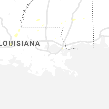
Louisiana
| Local Time | Report Details |
|---|---|
| 4:04 PM CDT | Social media report of tree down in garden distric in east baton rouge county LA, 52.8 miles ENE of Lafayette, LA |
| 5:32 PM CDT | Tree down on pleasant ridge road extension. reported by sheriffs offic in tangipahoa county LA, 41.3 miles NNW of New Orleans, LA |
| 5:32 PM CDT | Tree down on happywoods road. reported by sheriffs offic in tangipahoa county LA, 44.2 miles NW of New Orleans, LA |
| 5:45 PM CDT | Tree down on old uneedus rd. near global wildlife center. reported by sheriffs offic in tangipahoa county LA, 48.1 miles NNW of New Orleans, LA |
Alabama
| Local Time | Report Details |
|---|---|
| 4:06 PM CDT | Several trees and limbs down on powerlines and in the road along highway 225 near the bay minette communit in baldwin county AL, 17.6 miles NE of Mobile, AL |
| 3:15 AM UTC | Tree down on summer ln. winds estimated at 40-50 mph as suggested by radar and nearby surface ob at k1a in autauga county AL, 56.3 miles W of Auburn, AL |
Illinois
| Local Time | Report Details |
|---|---|
| 4:40 PM CDT | Quarter sized hail reported near Chicago, IL, 4.3 miles NW of Chicago, IL, video shared via social media in logan square. |
| 4:44 PM CDT | Shared image via social media of tree branch down. time estimated via rada in cook county IL, 4.6 miles N of Chicago, IL |
| 4:44 PM CDT | Reported at belmont harbo in lmz741 county IL, 3.9 miles N of Chicago, IL |
| 7:15 PM CDT | Golf Ball sized hail reported near Carthage, IL, 33.4 miles ESE of Kahoka, MO |
| 7:45 PM CDT | Quarter sized hail reported near Carthage, IL, 36 miles ESE of Kahoka, MO, trained spotter from ilx. |
| 12:50 AM UTC | Pine trees snapped off and few limbs down of unknown size. time estimated from radar. relayed from nws lincol in hancock county IL, 19.5 miles E of Kahoka, MO |
| 1:03 AM UTC | Storm damage reported in hancock county IL, 20.1 miles E of Kahoka, MO |
| 8:07 PM CDT | Estimated a 60 mph gus in hancock county IL, 19 miles E of Kahoka, MO |
| 8:07 PM CDT | Quarter sized hail reported near Hamilton, IL, 19 miles E of Kahoka, MO, a few quarter sized. |
| 1:15 AM UTC | Ping Pong Ball sized hail reported near La Harpe, IL, 39.3 miles ENE of Kahoka, MO, relayed by nws chicago. time estimated from radar. |
| 1:15 AM UTC | 15 foot tall bradford pear tree snapped off near base. time estimate in hancock county IL, 31.1 miles E of Kahoka, MO |
| 1:30 AM UTC | Time estimated. colchester without power. also pea hai in mcdonough county IL, 49 miles E of Kahoka, MO |
| 1:48 AM UTC | Storm damage reported in mcdonough county IL, 50.6 miles WSW of Peoria, IL |
| 1:55 AM UTC | Large tree limb blown down. swop repor in fulton county IL, 51.7 miles SW of Peoria, IL |
| 9:23 PM CDT | Quarter sized hail reported near Hanna City, IL, 11 miles WSW of Peoria, IL |
| 2:27 AM UTC | Storm damage reported in peoria county IL, 4.3 miles W of Peoria, IL |
| 2:27 AM UTC | Two trees blown down. power ou in peoria county IL, 4.3 miles W of Peoria, IL |
| 9:39 PM CDT | Delayed report. utility pole snapped and approx 6 inch diameter tree snapped at the corner of glen and university. time estimate in peoria county IL, 4.2 miles NNW of Peoria, IL |
| 2:40 AM UTC | 10 trees blown down. time estimate in peoria county IL, 3.5 miles NNW of Peoria, IL |
| 2:53 AM UTC | Tree blown down...taking down power line in woodford county IL, 9.3 miles NNE of Peoria, IL |
| 2:59 AM UTC | Storm damage reported in sangamon county IL, 64.3 miles S of Peoria, IL |
| 10:00 PM CDT | Large tree uprooted. time estimate in woodford county IL, 13.7 miles ENE of Peoria, IL |
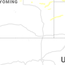
Wyoming
| Local Time | Report Details |
|---|---|
| 4:03 PM MDT | Ping Pong Ball sized hail reported near Torrington, WY, 29 miles WNW of Scottsbluff, NE, torrington airport reported hail between 1.25 and 1.50 inches in diameter. |
| 4:16 PM MDT | Quarter sized hail reported near Newcastle, WY, 56 miles SSE of Gillette, WY |
| 4:55 PM MDT | Quarter sized hail reported near Newcastle, WY, 71.8 miles SE of Gillette, WY |
| 5:44 PM MDT | Quarter sized hail reported near Manville, WY, 80.1 miles NW of Scottsbluff, NE |
| 5:47 PM MDT | Half Dollar sized hail reported near Manville, WY, 79.8 miles NW of Scottsbluff, NE, penny to half dollar size hail fell just south of manville. |
| 1:10 AM UTC | Asos station ktor torrington airpor in goshen county WY, 28.6 miles WNW of Scottsbluff, NE |
| 7:40 PM MDT | Quarter sized hail reported near Moorcroft, WY, 46.2 miles NNE of Gillette, WY |
| 7:50 PM MDT | Storm damage reported in crook county WY, 47.9 miles NE of Gillette, WY |
| 7:50 PM MDT | Ping Pong Ball sized hail reported near Hulett, WY, 47.9 miles NE of Gillette, WY |
| 2:09 AM UTC | Half Dollar sized hail reported near Hulett, WY, 54.3 miles NE of Gillette, WY |
| 2:10 AM UTC | Several trees uprooted in crook county WY, 51.1 miles NE of Gillette, WY |
| 2:25 AM UTC | Storm damage reported in crook county WY, 58.1 miles ENE of Gillette, WY |
| 8:50 PM MDT | Golf Ball sized hail reported near Aladdin, WY, 62.6 miles NW of Rapid City, SD |
Iowa
| Local Time | Report Details |
|---|---|
| 10:15 PM UTC | Quarter sized hail reported near Osceola, IA, 44.3 miles SSW of Des Moines, IA, via social media - delayed report. |
| 5:35 PM CDT | Quarter sized hail reported near Weldon, IA, 48 miles S of Des Moines, IA, swaths of stripped crops at the clarke/decatur county line - delayed report... time est. via radar. |
| 5:37 PM CDT | Quarter sized hail reported near Weldon, IA, 47.7 miles S of Des Moines, IA, quarter sized hail and small limb damage - delayed report... time est. via radar. |
| 5:40 PM CDT | Quarter sized hail reported near Creston, IA, 58.3 miles SW of Des Moines, IA, delayed report... via social media. |
| 5:50 PM CDT | Quarter sized hail reported near Creston, IA, 53.3 miles SW of Des Moines, IA, nickle and quarter size hail... delayed report relayed via dispatch. |
| 5:55 PM CDT | Quarter sized hail reported near Humeston, IA, 50.7 miles S of Des Moines, IA, reported at 6:04 pm radar indicated time was 5:55 pm. |
| 6:00 PM CDT | Quarter sized hail reported near Humeston, IA, 49 miles S of Des Moines, IA, via social media - delayed report. |
| 6:02 PM CDT | Golf Ball sized hail reported near Plano, IA, 58.4 miles SSE of Des Moines, IA, corp of engineers person called dispatch to report golf ball hail. |
| 6:20 PM CDT | Trees down blocking one lane of highway in appanoose county IA, 58 miles WNW of Kahoka, MO |
| 6:32 PM CDT | Tree down on a power line in lamoni - relayed via dispatch... time est. via rada in decatur county IA, 69 miles SSW of Des Moines, IA |
| 6:32 PM CDT | Report of tree down on power line in west grove - delayed report via social media... time est. via rada in davis county IA, 48.6 miles WNW of Kahoka, MO |
| 6:52 PM CDT | Half Dollar sized hail reported near Centerville, IA, 63.7 miles WNW of Kahoka, MO |
| 6:55 PM CDT | Quarter sized hail reported near Centerville, IA, 64.2 miles WNW of Kahoka, MO, via social media. |
| 6:55 PM CDT | Golf Ball sized hail reported near Centerville, IA, 64.2 miles WNW of Kahoka, MO, golf ball hail fell for several minutes before becoming smaller in size. a severe weather spotter reported 1/2 inch diameter branches snapped at the same time as the ha |
| 7:06 PM CDT | Quarter sized hail reported near Lineville, IA, 69.2 miles S of Des Moines, IA, via social media - delayed report. |
| 7:49 PM CDT | 2 to 3 inch diameter liimbs down. wind estimated to be 50 to 60 mp in lee county IA, 14.3 miles E of Kahoka, MO |
| 12:52 AM UTC | Lots of nickel size hail as wel in lee county IA, 14.3 miles E of Kahoka, MO |
| 12:55 AM UTC | Tree fell on a house. relayed by spotter. heard on scanner traffic. time estimate in lee county IA, 17.5 miles ENE of Kahoka, MO |
| 12:55 AM UTC | Storm damage reported in lee county IA, 15.6 miles ENE of Kahoka, MO |
| 7:58 PM CDT | Corrects previous tstm wnd gst report from keokuk. heard things snapping in the wind with small twigs and leaves in the air. reports several 5 to 6 inch limbs broken wi in lee county IA, 16.3 miles E of Kahoka, MO |
| 7:59 PM CDT | Quarter sized hail reported near Keokuk, IA, 16.3 miles E of Kahoka, MO, pea to quarter sized hail. |
| 8:00 PM CDT | Tree down in keokuk. also dime to nickel hail for past 5 minutes. major storm. power out for a whil in lee county IA, 16.9 miles E of Kahoka, MO |
| 1:15 AM UTC | Large trees down. time estimate in lee county IA, 14.3 miles E of Kahoka, MO |
| 8:40 PM CDT | Quarter sized hail reported near Murray, IA, 42.4 miles SSW of Des Moines, IA, sporadic quarter hail mixed with heavy rain... still ongoing. |
| 1:40 AM UTC | Quarter sized hail reported near Osceola, IA, 35.9 miles SSW of Des Moines, IA, relayed via broadcast media. |
| 8:42 PM CDT | Golf Ball sized hail reported near Prescott, IA, 65 miles SW of Des Moines, IA, via social media - delayed report. |
| 8:52 PM CDT | Quarter sized hail reported near Murray, IA, 41.7 miles SSW of Des Moines, IA, via social media. |
| 8:52 PM CDT | Golf Ball sized hail reported near Murray, IA, 42.4 miles SSW of Des Moines, IA, increased to golfball sized. while on the phone indicated that some even larger may have started to fall. |
| 8:55 PM CDT | Hen Egg sized hail reported near Murray, IA, 42.4 miles SSW of Des Moines, IA, mix of quarter to hen egg sized hail. |
| 8:56 PM CDT | Quarter sized hail reported near Murray, IA, 41.7 miles SSW of Des Moines, IA, law enforcement reported quarter size hail in murray. |
| 9:10 PM CDT | Half Dollar sized hail reported near Elliott, IA, 50.2 miles E of Omaha, NE, delayed report from social media. |
| 9:35 PM CDT | Quarter sized hail reported near Prescott, IA, 62.1 miles SW of Des Moines, IA |
| 12:01 AM CDT | Quarter sized hail reported near Corning, IA, 63.7 miles WSW of Des Moines, IA, hand full of hail... various sizes. several quarter sized pieces. |
| 1:11 AM CDT | Quarter sized hail reported near Prescott, IA, 61.4 miles WSW of Des Moines, IA |
| 1:20 AM CDT | Ping Pong Ball sized hail reported near Prescott, IA, 60.6 miles WSW of Des Moines, IA, corrects previous hail report from 6 sse bridgewater. heavy amounts of dime to nickle hail with occasional quarters. a few stones slightly larger than half dollars. |
Arkansas
| Local Time | Report Details |
|---|---|
| 5:25 PM CDT | Quarter sized hail reported near White Hall, AR, 33.8 miles SSE of Little Rock, AR, hail was falling at highway 104 and i-530. |
| 5:45 PM CDT | A large limb was blown down on grant county road 1 in grant county AR, 33.4 miles SSW of Little Rock, AR |
Montana
| Local Time | Report Details |
|---|---|
| 4:38 PM MDT | Half Dollar sized hail reported near Saint Xavier, MT, 44.2 miles SE of Billings, MT, half dollar size hail reported. |
| 5:12 PM MDT | Storm damage reported in big horn county MT, 72.6 miles ESE of Billings, MT |
| 5:13 PM MDT | Golf Ball sized hail reported near Lodge Grass, MT, 61.3 miles ESE of Billings, MT |
Michigan
| Local Time | Report Details |
|---|---|
| 11:00 PM UTC | Storm damage reported in lmz043 county MI, 52.7 miles E of Chicago, IL |
Mississippi
| Local Time | Report Details |
|---|---|
| 6:15 PM CDT | Small tree down on a fence... sub severe winds est between 40-50 mp in lamar county MS, 71.3 miles SSE of Jackson, MS |
| 6:20 PM CDT | Tree down on whiddon rd and a tree on a house on haven rd. est sub severe wind gusts of 50 mp in lamar county MS, 87.4 miles SSE of Jackson, MS |
| 6:20 PM CDT | Small tree downed power lines. est 50 mph wind in lamar county MS, 83.3 miles SSE of Jackson, MS |
| 6:30 PM CDT | A few trees down on power lines on ford r in forrest county MS, 83.1 miles WNW of Mobile, AL |
| 6:32 PM CDT | *** 1 inj *** a couple of trees down across laurel. one limb fell on a man causing a minor inj. est winds 40-50 mp in jones county MS, 75.1 miles SE of Jackson, MS |
| 11:43 PM UTC | Trees down on ralston r in forrest county MS, 80.6 miles WNW of Mobile, AL |
| 6:50 PM CDT | Tree downed a power line... which then fell on a house and caused a fire. est wind gust 40-50 mp in jones county MS, 71.8 miles ESE of Jackson, MS |
| 11:50 PM UTC | Several trees down in the n-central part of the county... from conehatta to union to decatu in newton county MS, 59.7 miles ENE of Jackson, MS |
| 12:07 AM UTC | A few trees down across chunky duffee r in newton county MS, 69.7 miles S of Starkville, MS |
Indiana
| Local Time | Report Details |
|---|---|
| 7:45 PM EDT | Quarter sized hail reported near New Carlisle, IN, 59.2 miles ESE of Chicago, IL |
Missouri
| Local Time | Report Details |
|---|---|
| 7:06 PM CDT | Golf Ball sized hail reported near Watson, MO, 56.4 miles SSE of Omaha, NE |
| 7:35 PM CDT | Quarter sized hail reported near Unionville, MO, 68.1 miles W of Kahoka, MO |
| 12:42 AM UTC | Reported 4 inch limbs and power lines down in kahok in clark county MO, 0.6 miles N of Kahoka, MO |
| 8:48 AM UTC | Tree down... partial road blockage at p highway and black cat r in jasper county MO, 63 miles SE of Chanute, KS |
| 8:52 AM UTC | Tree down... partial road blockage at main and wiggins in front of mark twain schoo in jasper county MO, 56.3 miles W of Springfield, MO |
Connect with Interactive Hail Maps