

Hail Map for Saturday, June 3, 2023

Number of Impacted Households on 6/3/2023
0
Impacted by 1" or Larger Hail
0
Impacted by 1.75" or Larger Hail
0
Impacted by 2.5" or Larger Hail
Square Miles of Populated Area Impacted on 6/3/2023
0
Impacted by 1" or Larger Hail
0
Impacted by 1.75" or Larger Hail
0
Impacted by 2.5" or Larger Hail


Cities Most Affected by Hail Storms of 6/3/2023
| Hail Size | Demographics of Zip Codes Affected | ||||||
|---|---|---|---|---|---|---|---|
| City | Count | Average | Largest | Pop Density | House Value | Income | Age |
| Ozona, TX | 1 | 2.50 | 2.50 | 0 | $52k | $29.9k | 39.5 |
| Pontotoc, TX | 1 | 2.00 | 2.00 | 1 | $38k | $24.8k | 60.6 |
| Harrisburg, PA | 1 | 1.75 | 1.75 | 4297 | $68k | $20.3k | 46.0 |
| Panhandle, TX | 1 | 1.75 | 1.75 | 1 | $58k | $41.5k | 39.8 |
| Clovis, NM | 1 | 1.75 | 1.75 | 93 | $66k | $28.9k | 31.3 |
| Rochelle, TX | 1 | 1.75 | 1.75 | 2 | $53k | $31.2k | 52.4 |
Hail and Wind Damage Spotted on 6/3/2023
Filter by Report Type:Hail ReportsWind Reports
States Impacted
Texas, Florida, Maryland, West Virginia, Pennsylvania, Utah, Arkansas, Oklahoma, Kansas, Wisconsin, Virginia, Louisiana, New Mexico, Kentucky, Indiana, Ohio, North CarolinaTexas
| Local Time | Report Details |
|---|---|
| 11:30 AM CDT | Gas station awning knocked dow in brazos county TX, 77.5 miles NW of Houston, TX |
| 1:28 PM CDT | Several trees snapped and uprooted south of alto... texas along cr 270 in cherokee county TX, 26.9 miles NW of Lufkin, TX |
| 3:40 PM CDT | Golf Ball sized hail reported near Rochelle, TX, 84.3 miles SSE of Abilene, TX, corrects previous hail report from 2 wsw placid. |
| 3:45 PM CDT | Quarter sized hail reported near Rochelle, TX, 83.6 miles SSE of Abilene, TX |
| 3:49 PM CDT | A tree was downed across cr 1601 near avinge in cass county TX, 52.4 miles WNW of Shreveport, LA |
| 3:49 PM CDT | A tree was downed across highway 8 south of douglassvill in cass county TX, 56.3 miles NW of Shreveport, LA |
| 3:50 PM CDT | Numerous trees downed across the northern half of rusk county or between kilgore and henderson... texa in rusk county TX, 64.3 miles WSW of Shreveport, LA |
| 4:01 PM CDT | 50kt or 58 mph wind gust measured at the gregg county airport in longview... texa in gregg county TX, 57 miles W of Shreveport, LA |
| 4:02 PM CDT | 52kt or 60 mph wind gust measured at the gregg county airport in longview... texa in gregg county TX, 57.6 miles W of Shreveport, LA |
| 5:35 PM CDT | Hen Egg sized hail reported near Pontotoc, TX, 79.1 miles W of Killeen, TX |
| 6:14 PM CDT | Quarter sized hail reported near Eldorado, TX, 110.3 miles N of Del Rio, TX |
| 6:59 PM CDT | Quarter sized hail reported near Bovina, TX, 65.7 miles SE of Tucumcari, NM |
| 7:00 PM CDT | Quarter sized hail reported near Hereford, TX, 41.8 miles SW of Amarillo, TX, quarter sized hail reported southwest of hereford. |
| 7:04 PM CDT | Quarter sized hail reported near Wildorado, TX, 24.1 miles WSW of Amarillo, TX, quarter size hail reported approx 8 miles south of wildorado relayed by local media. |
| 7:07 PM CDT | Quarter sized hail reported near Desoto, TX, 10.7 miles SSW of Dallas, TX, reports of marble to quarter size hail in northern desoto. |
| 7:44 PM CDT | Quarter sized hail reported near Clifton, TX, 53.2 miles NNE of Killeen, TX, trained spotter reported pea to nickel size hail with a few quarters mixed in 2 s of laguna park. |
| 7:45 PM CDT | Ping Pong Ball sized hail reported near Rio Grande City, TX, 84.3 miles SSE of Laredo, TX, public reported estimated ping pong size hail on fm 3167 in rio grande city with picture on social media. time estimated from radar. |
| 8:12 PM CDT | Half Dollar sized hail reported near Amarillo, TX, 10.8 miles ENE of Amarillo, TX, half dollar sized hail observed near highland park via social media. |
| 8:15 PM CDT | Half Dollar sized hail reported near Big Lake, TX, 80.7 miles SE of Odessa, TX, report from mping: half dollar (1.25 in.). |
| 8:17 PM CDT | Golf Ball sized hail reported near Panhandle, TX, 15.1 miles E of Amarillo, TX, golf ball sized hail reported near fm2575 east of amarillo. |
| 8:29 PM CDT | Half Dollar sized hail reported near Amarillo, TX, 9.3 miles E of Amarillo, TX, report from mping: half dollar (1.25 in.). |
| 8:30 PM CDT | Quarter sized hail reported near Ennis, TX, 32 miles SSE of Dallas, TX, report of quarter (1.00 in.) size hail. |
| 8:41 PM CDT | Ping Pong Ball sized hail reported near Ozona, TX, 83.3 miles SE of Odessa, TX, report from mping: ping pong ball (1.50 in.). |
| 8:54 PM CDT | Tennis Ball sized hail reported near Ozona, TX, 83.3 miles SE of Odessa, TX |
| 8:58 PM CDT | Gas station canopy partially destroyed. time estimated from rada in randall county TX, 16.4 miles SSW of Amarillo, TX |
| 9:09 PM CDT | 59 mph thunderstorm wind gusts measured at austin bergstrom international airpor in travis county TX, 63.3 miles S of Killeen, TX |
| 9:43 PM CDT | West texas mesonet in swisher county TX, 32.2 miles S of Amarillo, TX |
| 11:20 PM CDT | Asos station kcll easterwood field airpor in brazos county TX, 82.3 miles NW of Houston, TX |
| 11:20 PM CDT | Mesonet station 1757w texas a&m kyle fiel in brazos county TX, 82.4 miles NW of Houston, TX |
| 11:30 PM CDT | Corrects previous tstm wnd dmg report from 2 ne up429. gas station awning knocked dow in brazos county TX, 77.5 miles NW of Houston, TX |
| 11:40 PM CDT | Kyle field mesonet site measured 85 mph wind gus in brazos county TX, 82.4 miles NW of Houston, TX |
| 11:50 PM CDT | Large tree limbs downed and blocking the street on ennis stree in brazos county TX, 86.2 miles NW of Houston, TX |
| 11:50 PM CDT | Large tree limbs downed and blocking the street on ennis stree in brazos county TX, 86.2 miles NW of Houston, TX |
| 12:06 AM CDT | Ew4261 mesonet site measured 69 mph wind gus in grimes county TX, 52.5 miles NW of Houston, TX |
| 12:23 AM CDT | Law enforcement dispatch reported multiple downed trees throughout the count in grimes county TX, 61.6 miles NW of Houston, TX |
| 12:45 AM CDT | Numerous large branches downed across the city of magnoli in montgomery county TX, 38.5 miles NW of Houston, TX |
| 1:35 AM CDT | Houston dunn asos station measured 59 mph wind gus in harris county TX, 0 miles SSW of Houston, TX |
| 1:37 AM CDT | Asos station kiah houston intn in harris county TX, 16.5 miles N of Houston, TX |
| 1:37 AM CDT | Bush intercontinental airport asos station measured 62 mph wind gus in harris county TX, 15.9 miles N of Houston, TX |
Florida
| Local Time | Report Details |
|---|---|
| 1:00 PM EDT | A partial roof collapse of a duplex apartment building was reported shortly after a thunderstorm moved through the region producing wind gusts in excess of 70 mp in broward county FL, 18.3 miles N of Miami, FL |
| 1:07 PM EDT | Quarter sized hail reported near Hollywood, FL, 20.9 miles N of Miami, FL, city of hollywood emergency management reported quarter-sized hail in the hollywood hills area. time estimated from radar. |
| 1:19 PM EDT | A thunderstorm produced a wind gust at asos station kfll fort lauderdale/hollywood intl airpor in broward county FL, 24.1 miles NNE of Miami, FL |
| 1:20 PM EDT | A thunderstorm produced a wind gust of 83 mph at mesonet station 1694w ft lauderdal in broward county FL, 24.9 miles NNE of Miami, FL |
| 1:30 PM EDT | Half Dollar sized hail reported near Fort Lauderdale, FL, 25.4 miles NNE of Miami, FL, marina mile and 9th ave. half dollar sized hail. |
| 1:30 PM EDT | A thunderstorm produced a wind gust of 72 mph at mesonet station 1694w fswn ft. lauderdal in broward county FL, 24.9 miles NNE of Miami, FL |
| 2:00 PM EDT | Quarter sized hail reported near Lake Worth, FL, 49.2 miles SSE of Port Saint Lucie, FL, nickel to quarter sized hail was reported along wright drive just west of i-95 in lake worth. |
| 2:25 PM EDT | Quarter sized hail reported near Boynton Beach, FL, 54.5 miles N of Miami, FL, quarter sized hail was reported at the intersection of congress blvd and woolbright rd with widespread street flooding. |
Maryland
| Local Time | Report Details |
|---|---|
| 1:05 PM EDT | Quarter sized hail reported near Accident, MD, 56.2 miles NNE of Elkins, WV, broadcast meteorologist relayed public report of quarter-sized hail near accident. |
| 1:31 PM EDT | Tree down on the 2000 block of oakland sang run road in garrett county MD, 44.6 miles NNE of Elkins, WV |
West Virginia
| Local Time | Report Details |
|---|---|
| 2:05 PM EDT | Tree down along route 72/river rd in preston county WV, 36.5 miles NNE of Elkins, WV |
| 2:10 PM EDT | Tree down on 72 outside of rowlesburg in preston county WV, 30.5 miles NNE of Elkins, WV |
| 2:14 PM EDT | Tree down along frog hollow rd in preston county WV, 29.9 miles N of Elkins, WV |
| 2:25 PM EDT | Tree branch down along route 26 in preston county WV, 29.4 miles N of Elkins, WV |
| 3:31 PM EDT | Tree down on phillips dairy rd. all the way across road... closer to heavner grove side. no lines involved. tree came off the ban in upshur county WV, 21.3 miles WNW of Elkins, WV |
| 3:42 PM EDT | Power lines down across both lanes at parkway st. and virginia ave. power poles still up. reported at 4:23 pm. event time estiemated from rada in raleigh county WV, 45.7 miles SSE of Charleston, WV |
| 3:42 PM EDT | Tree down completely blocking waterlom rd. in a sharp turn in french creek. reported at 4:35 pm. event time estimated from rada in upshur county WV, 24.6 miles WSW of Elkins, WV |
| 3:42 PM EDT | Tree fell across power lines on beeechtown rd. in french creek partially blocking road... and power is out in the are in upshur county WV, 24.9 miles W of Elkins, WV |
| 3:42 PM EDT | Tree down between game farm ponds and rock cave reported by numerous callers through 4:41 pm. event time estimated from rada in upshur county WV, 27.3 miles WSW of Elkins, WV |
| 4:01 PM EDT | Tree down blocking northbound lane of south rd. in french cree in upshur county WV, 24.9 miles W of Elkins, WV |
| 4:52 PM EDT | Large tree just fell on south rd. before linger chair factor in upshur county WV, 27.3 miles WSW of Elkins, WV |
| 6:05 PM EDT | Quarter sized hail reported near Pennsboro, WV, 65.3 miles WNW of Elkins, WV, large amount of hail in the pennsboro area. also several trees and lines down as well. fire department currently out assessing damages. |
| 6:05 PM EDT | Several trees and lines down in the pennsboro area. large amount of hail as well. fire department currently out assessing damage in ritchie county WV, 65.3 miles WNW of Elkins, WV |
| 6:08 PM EDT | Tree down on myles ave.... the main drag through town. it took down power and phone lines and was blocking the road. utility crews were still there at time of call... 9 in ritchie county WV, 65.3 miles WNW of Elkins, WV |
| 6:33 PM EDT | Tree down at indian creek rd. and rena mae dr. blocking northbound lan in kanawha county WV, 9.6 miles ENE of Charleston, WV |
| 6:35 PM EDT | Trees down at the commission on age parking lot on stweart st. a few cars there were hit. report time 733 pm. event time estimated from rada in mcdowell county WV, 63.5 miles S of Charleston, WV |
| 6:48 PM EDT | Tree down on maple st. report time 704 pm. event time estimated from rada in putnam county WV, 20.5 miles NW of Charleston, WV |
| 6:56 PM EDT | Tree down on route 2. also small hail around the same time. time range given fine-tuned from rada in pleasants county WV, 78.8 miles WNW of Elkins, WV |
Pennsylvania
| Local Time | Report Details |
|---|---|
| 2:34 PM EDT | Tree down on power lines along us 422 in indiana county PA, 44.3 miles ENE of Pittsburgh, PA |
| 3:10 PM EDT | Quarter sized hail reported near Lake Ariel, PA, 15 miles ESE of Scranton, PA, quarter sized hail along with winds strong enough to cause power outage at restaurant. radar-estimated time. |
| 4:12 PM EDT | Tree down in shamokin townshi in northumberland county PA, 61.5 miles E of State College, PA |
| 4:35 PM EDT | Quarter sized hail reported near Glenshaw, PA, 7.3 miles NNE of Pittsburgh, PA, picture provided |
| 4:47 PM EDT | Multiple trees down... tree limbs on power lines also reported near east buffalo township. time estimated by rada in union county PA, 51 miles ENE of State College, PA |
| 5:14 PM EDT | Tree down on a car in canonsburg on n central ave in washington county PA, 16 miles SW of Pittsburgh, PA |
| 5:19 PM EDT | Sr 19 closed due to fallen trees and wires in washington county PA, 17.3 miles SW of Pittsburgh, PA |
| 5:28 PM EDT | Quarter sized hail reported near Carmichaels, PA, 39.9 miles S of Pittsburgh, PA, along route 21 |
| 5:28 PM EDT | Quarter sized hail reported near Washington, PA, 19 miles SW of Pittsburgh, PA, along i-79 near racetrack rd and fischer rd |
| 5:29 PM EDT | Trees down on wires along creek rd in greene county PA, 36.8 miles S of Pittsburgh, PA |
| 5:32 PM EDT | Trees down near braden run rd and route 188 in greene county PA, 36.4 miles S of Pittsburgh, PA |
| 5:45 PM EDT | Multiple trees dow in snyder county PA, 38.5 miles E of State College, PA |
| 5:47 PM EDT | Trees down near orndorff rd and route 218 in greene county PA, 41.3 miles SSW of Pittsburgh, PA |
| 5:55 PM EDT | Some reports of wires and trees down in centre township and windsor township. time estimated from radar and from nearby spotter repor in berks county PA, 65.9 miles SSW of Scranton, PA |
| 5:55 PM EDT | Ping Pong Ball sized hail reported near Richfield, PA, 41.5 miles E of State College, PA, ping pong sized hail reported along route 35 between richfield and mt. pleasant mills. |
| 6:03 PM EDT | Small tree split in half due to winds. corrects previous tstm wnd gst report from hambur in berks county PA, 63.7 miles SSW of Scranton, PA |
| 6:03 PM EDT | Storm damage reported in berks county PA, 61 miles SSW of Scranton, PA |
| 6:06 PM EDT | Corrects previous tstm wnd dmg report from centerport. metal roof covering partially blown off a residence on maple street in centerport. time estimated from radar and in berks county PA, 66.1 miles SSW of Scranton, PA |
| 6:45 PM EDT | Utility lines and trees down across the roa in snyder county PA, 41.8 miles E of State College, PA |
| 7:10 PM EDT | Tree fell down... struck and knocked over a power line. time estimated by rada in blair county PA, 28.7 miles SW of State College, PA |
| 7:17 PM EDT | Tree down across west-bound lan in blair county PA, 29.3 miles SW of State College, PA |
| 7:37 PM EDT | Power lines dow in dauphin county PA, 60.1 miles ESE of State College, PA |
| 7:42 PM EDT | Quarter sized hail reported near Hollidaysburg, PA, 37.5 miles SW of State College, PA, spotter reports quarter sized hail in holidaysburg. |
| 7:52 PM EDT | Ping Pong Ball sized hail reported near Harrisburg, PA, 64.5 miles ESE of State College, PA |
| 7:53 PM EDT | Traffic light blown down and blocking the roadway. time estimated by rada in dauphin county PA, 64.7 miles ESE of State College, PA |
| 8:02 PM EDT | Ping Pong Ball sized hail reported near Harrisburg, PA, 63.9 miles ESE of State College, PA, 1.5 inch hail reported north of 81 in harrisburg. |
| 8:03 PM EDT | Half Dollar sized hail reported near Harrisburg, PA, 63.1 miles SE of State College, PA, report from mping: half dollar (1.25 in.). |
| 8:06 PM EDT | Golf Ball sized hail reported near Harrisburg, PA, 63.4 miles SE of State College, PA |
| 8:07 PM EDT | Wind and hail damaged door and glass front of a business. time estimated by rada in dauphin county PA, 62.6 miles SE of State College, PA |
| 8:08 PM EDT | Multiple trees down throughout the county along with reports of trees on wire in dauphin county PA, 65.5 miles SE of State College, PA |
| 8:09 PM EDT | Quarter sized hail reported near Harrisburg, PA, 63.9 miles SE of State College, PA, report from mping: quarter (1.00 in.). |
| 8:12 PM EDT | Tree knocked dow in cumberland county PA, 63.4 miles SE of State College, PA |
Utah
| Local Time | Report Details |
|---|---|
| 12:40 PM MDT | Quarter sized hail reported near West Jordan, UT, 11.2 miles SSW of Salt Lake City, UT, estimated quarter sized hail in west jordan. |
| 1:03 PM MDT | Quarter sized hail reported near Salt Lake City, UT, 6.9 miles S of Salt Lake City, UT, received via social media. |
Arkansas
| Local Time | Report Details |
|---|---|
| 1:42 PM CDT | Kfyv aso in washington county AR, 45.4 miles NNE of Fort Smith, AR |
| 1:45 PM CDT | Fire department reporting power line down on adams st. in lavaca. report relayed via ham radi in sebastian county AR, 14.5 miles ESE of Fort Smith, AR |
| 2:07 PM CDT | Fire department responding to several power lines down in fort smith with arching electrical equipmen in sebastian county AR, 1.3 miles ENE of Fort Smith, AR |
| 2:15 PM CDT | Estimated wind gust of 60 mph. sheet metal peeled off of a roo in crawford county AR, 5.5 miles NE of Fort Smith, AR |
| 6:30 PM CDT | At 995 hwy 165 south trees downed including one downed onto a house. roof damage was also noted in the are in chicot county AR, 57.1 miles NNE of Bastrop, LA |
| 6:30 PM CDT | At 1167 hwy 208 west several trees were uproote in chicot county AR, 57.7 miles NNE of Bastrop, LA |
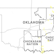
Oklahoma
| Local Time | Report Details |
|---|---|
| 1:46 PM CDT | Quarter sized hail reported near Ada, OK, 39.4 miles NW of Atoka, OK |
| 1:47 PM CDT | Quarter sized hail reported near Ada, OK, 39.4 miles NW of Atoka, OK |
| 1:49 PM CDT | Quarter sized hail reported near Ada, OK, 41.2 miles NW of Atoka, OK |
| 1:50 PM CDT | 6-12 inch diameter branch snapped. report relayed via social media. time estimated via rada in pontotoc county OK, 41.2 miles NW of Atoka, OK |
| 1:52 PM CDT | Measured with handheld anemometer. quarter size hail also observe in pontotoc county OK, 41.2 miles NW of Atoka, OK |
| 2:08 PM CDT | Fire department responding to downed power line with arching on the ground in arkoma at 108 nelle roa in le flore county OK, 2.6 miles SSW of Fort Smith, AR |
| 3:57 PM CDT | Large tree limb down west of via in sequoyah county OK, 35.8 miles WNW of Fort Smith, AR |
| 5:32 PM CDT | Minor damage to car wash. several large tree limbs down in that general are in tulsa county OK, 11.5 miles ESE of Tulsa, OK |
Kansas
| Local Time | Report Details |
|---|---|
| 2:22 PM CDT | Storm damage reported in montgomery county KS, 40.7 miles S of Chanute, KS |
| 2:23 PM CDT | Report via facebook. trees snappe in montgomery county KS, 28.9 miles S of Chanute, KS |
Wisconsin
| Local Time | Report Details |
|---|---|
| 4:01 PM CDT | Quarter sized hail reported near Pearson, WI, 27.9 miles SE of Rhinelander, WI |
Virginia
| Local Time | Report Details |
|---|---|
| 5:23 PM EDT | Tree down blocking one lane of breaks park rd. reported at 547 pm. event time estimated from rada in dickenson county VA, 42.8 miles N of Bristol, TN |
| 6:00 PM EDT | Scattered trees downed by thunderstorm winds in martinsville and eastern henry count in henry county VA, 45.3 miles S of Roanoke, VA |
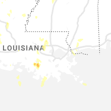
Louisiana
| Local Time | Report Details |
|---|---|
| 4:29 PM CDT | Reports of several trees and power lines downed in the vicinity of the calumet plant in shrevepor in caddo county LA, 4 miles SW of Shreveport, LA |
| 4:42 PM CDT | A tree was downed on waterwood drive and bea lane in greenwoo in caddo county LA, 12.7 miles WSW of Shreveport, LA |
| 4:50 PM CDT | Powerlines downed near avalon and mackey lane in southwest shrevepor in caddo county LA, 7.8 miles SSW of Shreveport, LA |
| 4:52 PM CDT | Powerlines downed on walker road between green terrace road and bert kouns industrial loo in caddo county LA, 8.7 miles SSW of Shreveport, LA |
| 5:00 PM CDT | Powerlines downed at the vicinity of fairfield... ockley and avery streets in shrevepor in caddo county LA, 3.1 miles S of Shreveport, LA |
| 5:05 PM CDT | Powerlines downed in the vicinity of wilkinson and gilbert drives in shrevepor in caddo county LA, 1.7 miles SSE of Shreveport, LA |
| 5:10 PM CDT | Large tree uprooted near stratford and broadmoor blvd near querbes golf course in shrevepor in caddo county LA, 2.9 miles SSE of Shreveport, LA |
| 5:10 PM CDT | Powerlines downed in the vicinity of georgia and dee streets in shrevepor in caddo county LA, 2.8 miles SE of Shreveport, LA |
| 5:11 PM CDT | Powerlines down in the vicinity of fairfield and e. 76th streets in shrevepor in caddo county LA, 5.1 miles S of Shreveport, LA |
| 5:20 PM CDT | Large limbs blown down in and around the converse and noble communities in northern sabine paris in sabine county LA, 50.7 miles S of Shreveport, LA |
| 5:59 PM CDT | A tree was downed on riverfront road in coushatt in red river county LA, 41.5 miles SSE of Shreveport, LA |
| 6:42 PM CDT | Quarter sized hail reported near Morgan City, LA, 61.1 miles WSW of New Orleans, LA, report and photo of quarter size hail (1 inch) passed on from nws lake charles. |
New Mexico
| Local Time | Report Details |
|---|---|
| 3:30 PM MDT | Quarter sized hail reported near Dora, NM, 77.5 miles ENE of Roswell, NM, report from twitter. |
| 5:30 PM MDT | Golf Ball sized hail reported near Clovis, NM, 55 miles SE of Tucumcari, NM |
| 7:01 PM MDT | Quarter sized hail reported near Las Vegas, NM, 54.3 miles S of Taos, NM, report from mping: quarter (1.00 in.). |
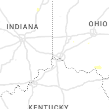
Kentucky
| Local Time | Report Details |
|---|---|
| 5:35 PM EDT | A tree was reported to have been blown down at 7705 marrowbone creek road/ky 195. the event time is radar estimate in pike county KY, 50.7 miles NNW of Bristol, TN |
| 6:01 PM EDT | A tree was reported to have been blown down at 1612 old ferrells creek roa in pike county KY, 52.8 miles N of Bristol, TN |
| 6:16 PM EDT | A tree was reported to have been blown down at 1250 fishtrap road. the event time is radar estimate in pike county KY, 58.2 miles N of Bristol, TN |
| 6:22 PM EDT | Large limbs blown down onto us 460 near the greasy creek road intersection and bridge per a social media post. the event time is radar estimate in pike county KY, 58.6 miles NNW of Bristol, TN |
Indiana
| Local Time | Report Details |
|---|---|
| 5:37 PM EDT | Likely wet microburst blew the side of a barn in... several large diameter trees damaged up to 48 inches in diameter... peeled roofing materials. time estimated from ra in wells county IN, 28 miles S of Fort Wayne, IN |
| 6:05 PM EDT | Picture on twitter of 1 partially rotten tree limb dow in elkhart county IN, 56.6 miles NW of Fort Wayne, IN |
| 6:05 PM EDT | Quarter sized hail reported near Elkhart, IN, 61.7 miles NW of Fort Wayne, IN, mainly pea to penny size hail... with picture shared of 1 quarter size hail stone near the elkhart and st joseph county line. |
Ohio
| Local Time | Report Details |
|---|---|
| 6:23 PM EDT | Large tree branch blown down at the intersectin of mccoy rd and camborne rd in upper arlingto in franklin county OH, 6.8 miles NW of Columbus, OH |
| 6:23 PM EDT | Tree down near intersection of fishinger rd and dublin rd. time estimated from radar dat in franklin county OH, 7 miles NW of Columbus, OH |
| 6:23 PM EDT | Large tree branch over fishinger rd just south of riverside dr. time estimated from radar dat in franklin county OH, 6.6 miles NW of Columbus, OH |
| 8:12 PM EDT | Tree limbs down. also pea-sized hail... and localized street flooding within the city. part of the city lost powe in gallia county OH, 44.3 miles NW of Charleston, WV |
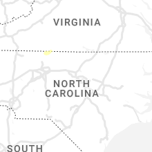
North Carolina
| Local Time | Report Details |
|---|---|
| 6:40 PM EDT | Trees down 1 mile south of 150 bridg in iredell county NC, 24.7 miles N of Charlotte, NC |
| 6:45 PM EDT | Multiple trees uprooted and powerlines dow in rockingham county NC, 54 miles S of Roanoke, VA |
| 6:46 PM EDT | Multiple large trees down in the ellett ave and church st area of ede in rockingham county NC, 53.3 miles S of Roanoke, VA |
| 6:47 PM EDT | Quarter sized hail reported near Eden, NC, 54.1 miles S of Roanoke, VA |
| 6:47 PM EDT | Widespread trees downed across eden... some on houses. along with numerous powerlines also dow in rockingham county NC, 54.8 miles S of Roanoke, VA |
| 6:54 PM EDT | Power lines down west of i7 in iredell county NC, 25.8 miles N of Charlotte, NC |
| 6:58 PM EDT | Trees down in the are in catawba county NC, 26.7 miles NNW of Charlotte, NC |
| 7:07 PM EDT | Quarter sized hail reported near Denver, NC, 22.5 miles NNW of Charlotte, NC |
| 7:12 PM EDT | Tree down with power lines down at pepper rd and pepper ridge c in guilford county NC, 75.4 miles S of Roanoke, VA |
| 7:12 PM EDT | Numerous trees and power lines down throughout forsyth count in forsyth county NC, 75.6 miles S of Roanoke, VA |
| 7:12 PM EDT | Tree down at old us highway 52 and welcome-bethesda r in davidson county NC, 56.9 miles NE of Charlotte, NC |
| 7:21 PM EDT | Tree down at gumtree rd and friendship-ledford r in davidson county NC, 65.7 miles NE of Charlotte, NC |
| 7:28 PM EDT | Multiple trees down on pine hall road between belews lake and pine hal in stokes county NC, 67.3 miles S of Roanoke, VA |
| 8:11 PM EDT | Multiple trees down. time estimate in davie county NC, 44.1 miles NNE of Charlotte, NC |
Connect with Interactive Hail Maps