

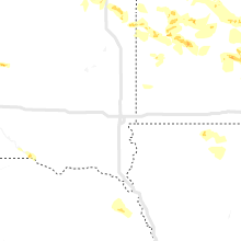
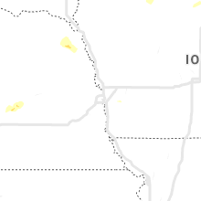
Hail Map for Tuesday, June 4, 2019

Number of Impacted Households on 6/4/2019
0
Impacted by 1" or Larger Hail
0
Impacted by 1.75" or Larger Hail
0
Impacted by 2.5" or Larger Hail
Square Miles of Populated Area Impacted on 6/4/2019
0
Impacted by 1" or Larger Hail
0
Impacted by 1.75" or Larger Hail
0
Impacted by 2.5" or Larger Hail


Cities Most Affected by Hail Storms of 6/4/2019
| Hail Size | Demographics of Zip Codes Affected | ||||||
|---|---|---|---|---|---|---|---|
| City | Count | Average | Largest | Pop Density | House Value | Income | Age |
| Dodge Center, MN | 4 | 2.25 | 2.50 | 43 | $86k | $43.8k | 35.2 |
| Kasson, MN | 2 | 2.25 | 2.75 | 127 | $119k | $52.4k | 34.3 |
| Cass Lake, MN | 1 | 2.50 | 2.50 | 16 | $61k | $27.9k | 32.5 |
| Bemidji, MN | 1 | 2.00 | 2.00 | 90 | $89k | $36.0k | 33.4 |
| Highmore, SD | 1 | 2.00 | 2.00 | 1 | $35k | $30.0k | 48.2 |
| Hope, NM | 1 | 2.00 | 2.00 | 0 | $55k | $36.7k | 44.0 |
| Bristow, NE | 1 | 1.75 | 1.75 | 1 | $16k | $26.9k | 53.3 |
| Holabird, SD | 1 | 1.75 | 1.75 | 1 | $19k | $42.0k | 43.0 |
| North Platte, NE | 1 | 1.75 | 1.75 | 50 | $79k | $36.3k | 38.7 |
| Woodbine, GA | 1 | 1.75 | 1.75 | 71 | $90k | $42.4k | 39.1 |
| Lester Prairie, MN | 1 | 1.75 | 1.75 | 46 | $98k | $47.1k | 37.0 |
| New Prague, MN | 1 | 1.75 | 1.75 | 146 | $137k | $51.6k | 35.9 |
| Silver Lake, MN | 1 | 1.75 | 1.75 | 28 | $89k | $44.7k | 40.4 |
| Jesup, GA | 1 | 1.75 | 1.75 | 171 | $75k | $31.8k | 36.3 |
Hail and Wind Damage Spotted on 6/4/2019
Filter by Report Type:Hail ReportsWind Reports
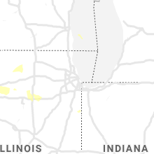
States Impacted
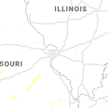
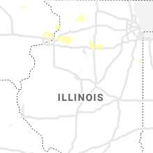
Illinois, Minnesota, New Mexico, Georgia, South Carolina, South Dakota, Missouri, Florida, Colorado, Texas, North Dakota, Arkansas, Nebraska, Wisconsin, IowaIllinois
| Local Time | Report Details |
|---|---|
| 11:08 AM CDT | Viewer reports powerlines down along highway 7 in henry county IL, 60.2 miles NNW of Peoria, IL |
| 11:38 AM CDT | Tree down blocking highway 2 in bureau county IL, 51.3 miles N of Peoria, IL |
| 10:34 PM CDT | 18-24 inch diameter tree down onto another tre in rock island county IL, 74.1 miles ESE of Cedar Rapids, IA |
| 11:08 PM CDT | Corrects previous tstm wnd dmg report from hooppole. viewer reports powerlines down along highway 7 in henry county IL, 60.2 miles NNW of Peoria, IL |
| 11:26 PM CDT | Large tree down blocking highway 4 in bureau county IL, 49.8 miles N of Peoria, IL |
| 11:38 PM CDT | Corrects previous tstm wnd dmg report from 3 n princeton. tree down blocking highway 2 in bureau county IL, 51.3 miles N of Peoria, IL |
| 11:52 PM CDT | Tree down on powerlines causing them to ar in bureau county IL, 47.9 miles N of Peoria, IL |
| 12:11 AM CDT | Delayed report. roof damage to a home and powerlines down across a roadway in the area where the damage occurred. report from illinois valley 911 dispatch relayed by br in la salle county IL, 59.9 miles NNE of Peoria, IL |
Minnesota
| Local Time | Report Details |
|---|---|
| 11:50 AM CDT | Quarter sized hail reported near Elbow Lake, MN, 65.7 miles NNW of Montevideo, MN, quarter sized hail and 0.80 inches of rain. |
| 1:07 PM CDT | Quarter sized hail reported near Kabetogama, MN, 13.5 miles SE of International Falls, MN, radar estimated time. |
| 1:52 PM CDT | Small limbs down across yar in stearns county MN, 55.9 miles WNW of Minneapolis, MN |
| 1:54 PM CDT | Small limbs down across yar in stearns county MN, 54.1 miles WNW of Minneapolis, MN |
| 2:00 PM CDT | Half Dollar sized hail reported near Montevideo, MN, 1 miles SW of Montevideo, MN, with photo on social media. |
| 2:01 PM CDT | Shingles ripped off shed... time estimated from rada in stearns county MN, 54.9 miles NW of Minneapolis, MN |
| 2:05 PM CDT | Corrects previous non-tstm wnd gst report from 2 w clara city. mesonet station mn021 clara city 2ws in chippewa county MN, 15.1 miles E of Montevideo, MN |
| 2:10 PM CDT | Time estimated from rada in stearns county MN, 55.1 miles WNW of Minneapolis, MN |
| 3:15 PM CDT | Storm damage reported in mcleod county MN, 55.2 miles W of Minneapolis, MN |
| 3:15 PM CDT | Power lines down all in one directio in mcleod county MN, 56.8 miles W of Minneapolis, MN |
| 3:15 PM CDT | Grain bins down... power lines dow in renville county MN, 56.8 miles E of Montevideo, MN |
| 3:29 PM CDT | Hector airport id 1d in renville county MN, 51.3 miles ESE of Montevideo, MN |
| 3:45 PM CDT | Golf Ball sized hail reported near Lester Prairie, MN, 41 miles W of Minneapolis, MN, hail between ping pong ball and golfball size. caller reported low vis due to dust and noted limbs down in the area. |
| 3:48 PM CDT | Golf Ball sized hail reported near Silver Lake, MN, 46.7 miles W of Minneapolis, MN |
| 4:10 PM CDT | Road sign blown down at hwy 169 and 1 in le sueur county MN, 41.8 miles SW of Minneapolis, MN |
| 4:12 PM CDT | Power lines down - 26400 block of german roa in scott county MN, 38.6 miles SW of Minneapolis, MN |
| 4:15 PM CDT | Quarter sized hail reported near New Prague, MN, 36.3 miles SSW of Minneapolis, MN, via emergency management. |
| 4:15 PM CDT | At hwy 25 and scenic bywa in carver county MN, 34.1 miles SW of Minneapolis, MN |
| 4:15 PM CDT | Tree down on highway 169 blocking one southbound lane. time estimated based on rada in le sueur county MN, 42.3 miles SW of Minneapolis, MN |
| 4:16 PM CDT | Power lines down at hwy 19 and 271st av in le sueur county MN, 40.5 miles SW of Minneapolis, MN |
| 4:17 PM CDT | Via emergency managemen in le sueur county MN, 36.3 miles SSW of Minneapolis, MN |
| 4:18 PM CDT | Near hwy 169 and 19 intersection. via emergency managemen in le sueur county MN, 41.8 miles SW of Minneapolis, MN |
| 4:18 PM CDT | Power lines down - iago blv in scott county MN, 33.4 miles SW of Minneapolis, MN |
| 4:20 PM CDT | Barn roof blown of in le sueur county MN, 36.3 miles SSW of Minneapolis, MN |
| 4:22 PM CDT | Tree down on railroad track in scott county MN, 32.8 miles SSW of Minneapolis, MN |
| 4:25 PM CDT | Golf Ball sized hail reported near New Prague, MN, 33.2 miles SSW of Minneapolis, MN, spotter called reporting hail between ping pong ball and golf ball sized. |
| 4:25 PM CDT | Tree and limbs down; roof blown off she in scott county MN, 35.1 miles SW of Minneapolis, MN |
| 4:26 PM CDT | Road sign blown down at hwy 13 and 19 intersectio in le sueur county MN, 33.2 miles SSW of Minneapolis, MN |
| 4:28 PM CDT | Trees down at 200th st. and harlo in scott county MN, 26.4 miles SSW of Minneapolis, MN |
| 4:30 PM CDT | Numerous 1 inch branches and a few larger branches about 3 inches in diameter down in belle plain in scott county MN, 34.7 miles SW of Minneapolis, MN |
| 4:30 PM CDT | Quarter sized hail reported near Granite Falls, MN, 15 miles SSE of Montevideo, MN, along highway23. |
| 4:33 PM CDT | Power lines dow in sibley county MN, 58.8 miles WSW of Minneapolis, MN |
| 4:34 PM CDT | Storm damage reported in scott county MN, 25.3 miles SSW of Minneapolis, MN |
| 4:35 PM CDT | Multiple trees down in north mankat in nicollet county MN, 67.4 miles SW of Minneapolis, MN |
| 4:35 PM CDT | Dispatch reports tree down on hwy 169 in north st. pete in nicollet county MN, 54.8 miles SW of Minneapolis, MN |
| 4:40 PM CDT | Measured... time estimated by rada in rice county MN, 51.7 miles SSW of Minneapolis, MN |
| 4:45 PM CDT | 16in diameter pine tree down on house. time estimated from rada in le sueur county MN, 38.2 miles SSW of Minneapolis, MN |
| 4:45 PM CDT | Sporadic tree damage varying in size up to 8 inch in diameter. outhouse tipped ove in scott county MN, 29.4 miles SSW of Minneapolis, MN |
| 4:45 PM CDT | 6-8 inch tree branches dow in dakota county MN, 34.9 miles S of Minneapolis, MN |
| 4:46 PM CDT | Quarter sized hail reported near Lakeville, MN, 20.7 miles S of Minneapolis, MN, 35w and 185th st. |
| 4:47 PM CDT | Multiple reports of large trees down... some with two or three foot diamete in rice county MN, 36.8 miles S of Minneapolis, MN |
| 4:49 PM CDT | Power line down at high and division street in sibley county MN, 55.1 miles WSW of Minneapolis, MN |
| 4:50 PM CDT | Storm damage reported in rice county MN, 36.8 miles S of Minneapolis, MN |
| 4:53 PM CDT | Quarter sized hail reported near Granite Falls, MN, 17 miles SSE of Montevideo, MN, relayed from fsd. |
| 4:53 PM CDT | Several trees blown dow in dakota county MN, 15.8 miles SSE of Minneapolis, MN |
| 4:55 PM CDT | Quarter sized hail reported near Elko New Market, MN, 28.5 miles S of Minneapolis, MN, reported by two spotters in elko new market. |
| 4:55 PM CDT | Hen Egg sized hail reported near Dodge Center, MN, 63.5 miles NNE of Mason City, IA |
| 4:56 PM CDT | Quarter sized hail reported near Dodge Center, MN, 63 miles NNE of Mason City, IA, quarter-size hail. relayed via social media. |
| 4:57 PM CDT | 1 foot and larger diameter trees down at 35e and county rd 1 in dakota county MN, 15.1 miles S of Minneapolis, MN |
| 5:00 PM CDT | Quarter sized hail reported near Kasson, MN, 64.4 miles NNE of Mason City, IA, 0.5 to 1 inch hail. |
| 5:00 PM CDT | 3 power poles snapped and 1 fracture in le sueur county MN, 40.5 miles SW of Minneapolis, MN |
| 5:02 PM CDT | Hen Egg sized hail reported near Dodge Center, MN, 63.5 miles NNE of Mason City, IA |
| 5:02 PM CDT | Tennis Ball sized hail reported near Dodge Center, MN, 63.5 miles NNE of Mason City, IA |
| 5:04 PM CDT | Baseball sized hail reported near Kasson, MN, 65 miles NNE of Mason City, IA |
| 5:05 PM CDT | Tennis Ball sized hail reported near Dodge Center, MN, 63.5 miles NNE of Mason City, IA |
| 5:07 PM CDT | Quarter sized hail reported near Kasson, MN, 65 miles NNE of Mason City, IA, corrects previous hail report of ping pong size from kasson. |
| 5:07 PM CDT | Ping Pong Ball sized hail reported near Kasson, MN, 65 miles NNE of Mason City, IA, ping pong ball size hail. |
| 5:11 PM CDT | Trees down in cloque in carlton county MN, 18.8 miles WSW of Duluth, MN |
| 5:16 PM CDT | Half Dollar sized hail reported near Kasson, MN, 65.4 miles NNE of Mason City, IA |
| 5:16 PM CDT | Golf Ball sized hail reported near Kasson, MN, 65 miles NNE of Mason City, IA |
| 5:20 PM CDT | 8 inch tree down... reported by dispatc in rice county MN, 46.9 miles S of Minneapolis, MN |
| 5:31 PM CDT | Storm damage reported in freeborn county MN, 45.4 miles N of Mason City, IA |
| 5:34 PM CDT | Storm damage reported in freeborn county MN, 46.7 miles N of Mason City, IA |
| 5:35 PM CDT | Storm damage reported in dodge county MN, 63.5 miles NNE of Mason City, IA |
| 5:50 PM CDT | Trees down over county road in itasca county MN, 46.8 miles ENE of Bemidji, MN |
| 5:56 PM CDT | Storm damage reported in olmsted county MN, 67.9 miles WNW of La Crosse, WI |
| 5:57 PM CDT | At apache mall in olmsted county MN, 62.8 miles WNW of La Crosse, WI |
| 5:59 PM CDT | Storm damage reported in olmsted county MN, 62.7 miles W of La Crosse, WI |
| 6:01 PM CDT | Storm damage reported in olmsted county MN, 62.7 miles W of La Crosse, WI |
| 6:27 PM CDT | Trained spotters estimated wind gust of 70 miles per hour four miles west of chatfield in fillmore county MN, 50.9 miles W of La Crosse, WI |
| 6:47 PM CDT | Storm damage reported in fillmore county MN, 42.4 miles WSW of La Crosse, WI |
| 6:47 PM CDT | Corrects previous tstm wnd gst report from 1 s harmony. location was just south of greenleafto in fillmore county MN, 50.8 miles WSW of La Crosse, WI |
| 7:28 PM CDT | Quarter sized hail reported near Monticello, MN, 31.8 miles NW of Minneapolis, MN |
| 7:39 PM CDT | Quarter sized hail reported near Bemidji, MN, 9.8 miles ESE of Bemidji, MN, em observed a wall cloud and quarter sized hail |
| 7:40 PM CDT | Hen Egg sized hail reported near Bemidji, MN, 7 miles E of Bemidji, MN, picture on social media with ruler of 2.1 inch hailstone with time estimated based on radar |
| 7:40 PM CDT | Sheriff deputy reported that strong winds had downed 8-10 mature trees at their base and uprooting half a dozen reported via beltrami em in beltrami county MN, 6.1 miles E of Bemidji, MN |
| 7:46 PM CDT | Tennis Ball sized hail reported near Cass Lake, MN, 9 miles SE of Bemidji, MN, video on social media showing multiple hail stones ping pong sized and greater with some as large as tennis balls |
| 7:48 PM CDT | Ping Pong Ball sized hail reported near Cass Lake, MN, 9 miles SE of Bemidji, MN, beltrami em observed hail on north side of midge lake just under golf ball size estimated as ping pong ball size. |
| 8:05 PM CDT | Quarter sized hail reported near Bemidji, MN, 5.7 miles SE of Bemidji, MN, beltrami em observed ongoing quarter size hail just south of county line in hubbard county. |
New Mexico
| Local Time | Report Details |
|---|---|
| 12:00 PM MDT | Quarter sized hail reported near Nogal, NM, 67.7 miles W of Roswell, NM |
| 12:32 PM MDT | Quarter sized hail reported near Cloudcroft, NM, 66.2 miles WSW of Roswell, NM |
| 2:25 PM MDT | Ping Pong Ball sized hail reported near Mayhill, NM, 52.5 miles SW of Roswell, NM |
| 2:42 PM MDT | Half Dollar sized hail reported near Hope, NM, 52.4 miles SW of Roswell, NM, hail is reported to be covering highway 82. |
| 2:54 PM MDT | Ping Pong Ball sized hail reported near Hope, NM, 49.6 miles SW of Roswell, NM |
| 3:00 PM MDT | Hen Egg sized hail reported near Hope, NM, 52.4 miles SW of Roswell, NM |
| 4:55 PM MDT | Storm damage reported in otero county NM, 79.5 miles NNE of El Paso, TX |
| 5:00 PM MDT | Half Dollar sized hail reported near La Luz, NM, 81.1 miles WSW of Roswell, NM |
| 5:03 PM MDT | Storm damage reported in otero county NM, 86.6 miles NNE of El Paso, TX |
Georgia
| Local Time | Report Details |
|---|---|
| 2:04 PM EDT | A few tree tops were broken along thompson pond road near the county lin in montgomery county GA, 57.3 miles NNE of Douglas, GA |
| 2:12 PM EDT | A tree was reported down along highway 46 near lake wildwoo in treutlen county GA, 65.1 miles NNE of Douglas, GA |
| 3:22 PM EDT | Golf Ball sized hail reported near Woodbine, GA, 43.5 miles N of Jacksonville, FL, emergency management reported golf ball sized hail in woodbine. |
| 3:30 PM EDT | Golf Ball sized hail reported near Jesup, GA, 55.6 miles WSW of Savannah, GA, video showing hail estimated golf ball sized at oglethorpe and osteen branch roads to the northwest of jesup. |
| 3:35 PM EDT | Candler county 911 center reported a tree down along porter highway near the hendricks road intersection. time was estimated from radar dat in candler county GA, 59.2 miles WNW of Savannah, GA |
| 3:38 PM EDT | Screven county 911 center reported a tree blown down along highway 21 near the carver avenue intersection. time of event was estimated from radar dat in screven county GA, 55.1 miles NW of Savannah, GA |
| 3:39 PM EDT | Tree down on east ogeechee st in sylvania. exact location unknown. time estimated by rada in screven county GA, 53.9 miles SSE of Augusta, GA |
| 3:45 PM EDT | Ping Pong Ball sized hail reported near Portal, GA, 58.3 miles WNW of Savannah, GA, trained spotter reported hail the size of ping pong balls along metter road near the banks dairy road intersection. |
| 3:45 PM EDT | Trained spotter reported multiple trees and tree limbs blown down along metter road near the banks dairy road intersectio in bulloch county GA, 58.3 miles WNW of Savannah, GA |
| 4:24 PM EDT | Quarter sized hail reported near Newington, GA, 42.5 miles NW of Savannah, GA, a police officer reported quarter sized hail in newington. |
| 10:06 PM EDT | Trees down on the inner perimeter rd at east park avenue. took down a couple of traffic lights and power line in lowndes county GA, 48.9 miles SSW of Douglas, GA |
South Carolina
| Local Time | Report Details |
|---|---|
| 3:20 PM EDT | Park ranger from givhans ferry state park observed several large branches down greater than 3 inches in diameter and quarter size hail. time estimated from rada in colleton county SC, 24.7 miles WSW of Charleston, SC |
| 3:30 PM EDT | Quarter sized hail reported near Ridgeville, SC, 22.9 miles SW of Charleston, SC, quarter size hail reported near givhans ferry state park. |
| 3:30 PM EDT | Tree down on boat landing rd. time estimated based on radar and sc hwy patrol repor in dorchester county SC, 26.2 miles WSW of Charleston, SC |
| 3:31 PM EDT | Quarter sized hail reported near Ridgeville, SC, 24.6 miles SW of Charleston, SC, along old beech hill road. time estimated based on radar. |
| 3:36 PM EDT | Tree down at wild turkey lane and cottageville hwy. time estimated based on sc highway patrol websit in colleton county SC, 31.3 miles SW of Charleston, SC |
| 3:53 PM EDT | Tree down at cottageville hwy and camp buddy rd. time estimated based on sc highway patrol repor in colleton county SC, 29.5 miles SW of Charleston, SC |
| 3:58 PM EDT | Colleton county 911 center reported a tree blown down near the intersection of cottageville highway and sullivans ferry road. time of event was estimated from radar dat in colleton county SC, 31.3 miles SW of Charleston, SC |
| 4:26 PM EDT | Quarter sized hail reported near Salters, SC, 26.6 miles NNE of Charleston, SC, public reported quarter-sized hail via twitter near lane... sc. |
| 4:30 PM EDT | Corrects previous tstm wnd dmg report from 3 ne hilda. tree down at mill pond rd near hwy 70. time estimtae in bamberg county SC, 45.9 miles ESE of Augusta, GA |
| 4:35 PM EDT | According to bamberg co dispatch... trees were down on ehrhardt rd and on low country hwy (hwy 64). exact locations unknown. time estimate in bamberg county SC, 56.6 miles ESE of Augusta, GA |
| 4:40 PM EDT | Quarter sized hail reported near Lane, SC, 23.8 miles NNE of Charleston, SC, public shared video via twitter and confirmed that quarter-sized hail was falling east of lane. time estimated via radar. |
| 4:45 PM EDT | Tree down at parkers ferry rd and jacksonboro rd. time estimated based on sc hwy patrol report and rada in colleton county SC, 38.4 miles SW of Charleston, SC |
| 4:50 PM EDT | At 450 pm... asos station at marion county airport reported a wind gust of 62 mp in marion county SC, 78.4 miles NNE of Charleston, SC |
| 4:50 PM EDT | Public reported a couple of trees down that fell onto power lines along us-501 in marion county. time estimated via radar and previous report of 62 mph gust at marion c in marion county SC, 77.8 miles NNE of Charleston, SC |
| 6:23 PM EDT | Beaufort county 911 center reported a tree down on hilton head island along shelter cove lane near the william hilton parkway intersection. time of event was estimated in beaufort county SC, 22.8 miles ENE of Savannah, GA |
| 6:25 PM EDT | Tree down on on hampton drive. time estimated by rada in beaufort county SC, 36 miles NE of Savannah, GA |
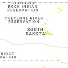
South Dakota
| Local Time | Report Details |
|---|---|
| 2:54 PM CDT | Hen Egg sized hail reported near Highmore, SD, 50.8 miles NE of Pierre, SD, 1.47 inches of rain. |
| 3:10 PM CDT | Quarter sized hail reported near Faulkton, SD, 49.2 miles WSW of Aberdeen, SD |
| 3:41 PM CDT | Quarter sized hail reported near Revillo, SD, 38 miles W of Montevideo, MN |
| 3:45 PM CDT | Quarter sized hail reported near Frederick, SD, 19 miles NNW of Aberdeen, SD, radar estimated time. |
| 3:50 PM CDT | Quarter sized hail reported near Highmore, SD, 45.2 miles E of Pierre, SD, ground covered in hail. some quarters... mostly dimes. |
| 3:54 PM CDT | Ping Pong Ball sized hail reported near Highmore, SD, 50.3 miles E of Pierre, SD |
| 4:12 PM CDT | Golf Ball sized hail reported near Holabird, SD, 37.2 miles E of Pierre, SD |
| 4:32 PM CDT | Storm damage reported in hand county SD, 56.5 miles E of Pierre, SD |
| 4:40 PM CDT | Half Dollar sized hail reported near Aberdeen, SD, 4.9 miles N of Aberdeen, SD |
| 6:36 PM CDT | Storm damage reported in brown county SD, 13.5 miles SSW of Aberdeen, SD |
| 7:06 PM CDT | Quarter sized hail reported near South Shore, SD, 60.3 miles WNW of Montevideo, MN, ground was covered with mostly small hail... but contained some quarter sized pieces. |
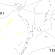
Missouri
| Local Time | Report Details |
|---|---|
| 2:55 PM CDT | Quarter sized hail reported near Caulfield, MO, 76.7 miles SSW of Salem, MO, public report of hail up to the size of quarters in caulfield. |
| 3:25 PM CDT | Report of a few trees blown down. in addition... a weather spotter reported pea sea hail and estimated 50 miles per hour wind in barry county MO, 40 miles WSW of Springfield, MO |
| 3:51 PM CDT | Report relayed by broadcast media of a large tree blown over into a home in iberia. time estimated from rada in miller county MO, 51.8 miles NW of Salem, MO |
| 4:09 PM CDT | Measured 62 mph wind gust at the springfield aso in greene county MO, 6.2 miles WNW of Springfield, MO |
| 4:45 PM CDT | Report of two power poles down on highway 215 between potters road and red top road. time estimated from rada in dallas county MO, 18.1 miles NNE of Springfield, MO |
| 5:09 PM CDT | Trees and power lines down across tow in gasconade county MO, 49.2 miles N of Salem, MO |
| 5:11 PM CDT | Corrects previous tstm wnd dmg report from 2 wsw gerald. tree damage... debris lofted into the ai in gasconade county MO, 52.7 miles N of Salem, MO |
| 5:11 PM CDT | Tree damage... debris lofted into the ai in gasconade county MO, 52.7 miles N of Salem, MO |
| 5:11 PM CDT | Trees... power lines... and signage blown down. time is estimated by rada in gasconade county MO, 52.5 miles N of Salem, MO |
| 5:20 PM CDT | Tree dow in franklin county MO, 52.7 miles NNE of Salem, MO |
| 5:56 PM CDT | Corrects previous report from 3 ese brownbranch. report of a few large trees across the road near the mcclurg cutof in taney county MO, 40.9 miles SE of Springfield, MO |
| 6:53 PM CDT | Tree down. time estimated from rada in washington county MO, 51.3 miles ENE of Salem, MO |
| 7:07 PM CDT | Power line and tree down. time estimated from rada in st. francois county MO, 52.4 miles SSW of Saint Louis, MO |
| 7:08 PM CDT | Power line and tree down. time estimated from rada in st. francois county MO, 56.6 miles SSW of Saint Louis, MO |
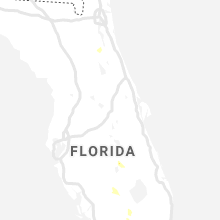
Florida
| Local Time | Report Details |
|---|---|
| 4:15 PM EDT | Tree down and blocking intersection of bardin road and state road 100 near palatka. time given based on rada in putnam county FL, 45.1 miles S of Jacksonville, FL |
Colorado
| Local Time | Report Details |
|---|---|
| 2:50 PM MDT | Half Dollar sized hail reported near Rush, CO, 55.8 miles NE of Pueblo, CO |
| 3:37 PM MDT | Quarter sized hail reported near Karval, CO, 74.3 miles ENE of Pueblo, CO |
Texas
| Local Time | Report Details |
|---|---|
| 3:16 PM MDT | Quarter sized hail reported near El Paso, TX, 15.2 miles ESE of El Paso, TX |
| 3:24 PM MDT | Quarter sized hail reported near Fabens, TX, 25.8 miles SE of El Paso, TX |
| 3:25 PM MDT | Storm damage reported in el paso county TX, 7.2 miles ENE of El Paso, TX |
| 11:10 PM CDT | Storm damage reported in deaf smith county TX, 42.6 miles SW of Amarillo, TX |
North Dakota
| Local Time | Report Details |
|---|---|
| 4:40 PM CDT | Recorded observation from an ndawn mesonet site. time of lsr report matches the observation tim in dickey county ND, 47 miles NNE of Aberdeen, SD |
Arkansas
| Local Time | Report Details |
|---|---|
| 5:30 PM CDT | A tree was blown down in hector... a in pope county AR, 63.8 miles NW of Little Rock, AR |
| 7:01 PM CDT | Trees downed causing power outage and blocking highwa in prairie county AR, 41.9 miles E of Little Rock, AR |
| 8:27 PM CDT | Power poles and trees down along county roads 701 and 716 and state highway 91. structure damage along county road 70 in lawrence county AR, 78.3 miles NW of Memphis, TN |
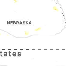
Nebraska
| Local Time | Report Details |
|---|---|
| 6:13 PM MDT | Quarter sized hail reported near Lemoyne, NE, 64.9 miles W of North Platte, NE, mostly pea size with a few quarter size stones. estimated 30 to 40 mph winds. time estimated from radar. |
| 6:33 PM MDT | Estimated 60 to 70 mph gust in keith county NE, 49.9 miles W of North Platte, NE |
| 7:39 PM CDT | Golf Ball sized hail reported near Bristow, NE, 39.1 miles N of Oneill, NE, time estimated via radar. |
| 6:44 PM MDT | Tree branch damage around property. time estimated from rada in keith county NE, 43.7 miles W of North Platte, NE |
| 7:15 PM MDT | Quarter sized hail reported near Paxton, NE, 29.6 miles W of North Platte, NE, time estimated from radar. |
| 8:18 PM CDT | Time estimated from radar in lincoln county NE, 23.5 miles WSW of North Platte, NE |
| 8:22 PM CDT | Time estimated from radar in lincoln county NE, 23.5 miles WSW of North Platte, NE |
| 9:01 PM CDT | Golf Ball sized hail reported near North Platte, NE, 21 miles SSW of North Platte, NE, hail lasted 10 to 15 minutes. winds estimated at 50 mph. time estimated from radar. |
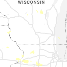
Wisconsin
| Local Time | Report Details |
|---|---|
| 8:01 PM CDT | Several trees reported down. time estimated from rada in monroe county WI, 24.5 miles ENE of La Crosse, WI |
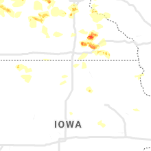
Iowa
| Local Time | Report Details |
|---|---|
| 10:21 PM CDT | Time estimated from rada in scott county IA, 61.5 miles ESE of Cedar Rapids, IA |
Connect with Interactive Hail Maps