

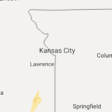
Hail Map for Thursday, May 11, 2017

Number of Impacted Households on 5/11/2017
0
Impacted by 1" or Larger Hail
0
Impacted by 1.75" or Larger Hail
0
Impacted by 2.5" or Larger Hail
Square Miles of Populated Area Impacted on 5/11/2017
0
Impacted by 1" or Larger Hail
0
Impacted by 1.75" or Larger Hail
0
Impacted by 2.5" or Larger Hail


Cities Most Affected by Hail Storms of 5/11/2017
| Hail Size | Demographics of Zip Codes Affected | ||||||
|---|---|---|---|---|---|---|---|
| City | Count | Average | Largest | Pop Density | House Value | Income | Age |
| Langston, OK | 4 | 2.25 | 2.75 | 0 | $31k | $17.6k | 19.8 |
| Bull Shoals, AR | 2 | 3.25 | 4.00 | 349 | $82k | $27.1k | 58.9 |
| Coyle, OK | 2 | 3.13 | 4.25 | 11 | $40k | $30.6k | 37.3 |
| Neosho, MO | 3 | 1.75 | 1.75 | 121 | $68k | $33.8k | 35.9 |
| Omaha, AR | 2 | 2.25 | 2.75 | 24 | $79k | $27.2k | 44.2 |
| Medicine Lodge, KS | 2 | 2.13 | 2.50 | 8 | $40k | $34.5k | 42.6 |
| Magazine, AR | 1 | 2.75 | 2.75 | 21 | $44k | $28.0k | 39.6 |
| Meridian, OK | 1 | 2.50 | 2.50 | 7 | $33k | $21.9k | 49.0 |
| Alpena, AR | 1 | 2.50 | 2.50 | 21 | $59k | $26.7k | 41.9 |
| Kingfisher, OK | 1 | 2.50 | 2.50 | 25 | $73k | $37.7k | 39.0 |
| Ladonia, TX | 1 | 1.75 | 1.75 | 14 | $39k | $29.3k | 44.5 |
| Sumner, TX | 1 | 1.75 | 1.75 | 25 | $61k | $37.6k | 39.4 |
| Celeste, TX | 1 | 1.75 | 1.75 | 31 | $54k | $40.0k | 40.5 |
| Catoosa, OK | 1 | 1.75 | 1.75 | 151 | $106k | $43.7k | 38.4 |
| Forsyth, MO | 1 | 1.75 | 1.75 | 71 | $87k | $30.5k | 47.9 |
| Springfield, KY | 1 | 1.75 | 1.75 | 44 | $75k | $33.1k | 40.6 |
| Mooreland, OK | 1 | 1.75 | 1.75 | 3 | $54k | $32.5k | 39.3 |
Hail and Wind Damage Spotted on 5/11/2017
Filter by Report Type:Hail ReportsWind Reports
States Impacted
Oklahoma, Missouri, Kansas, Texas, Arkansas, Kentucky, Washington, Virginia, North Carolina, Tennessee, LouisianaOklahoma
| Local Time | Report Details |
|---|---|
| 7:32 AM CDT | Half Dollar sized hail reported near Claremore, OK, 24.3 miles ENE of Tulsa, OK |
| 8:45 AM CDT | Quarter sized hail reported near Grove, OK, 74.2 miles ENE of Tulsa, OK, mostly pea to dime covering the ground |
| 9:05 AM CDT | Quarter sized hail reported near Wyandotte, OK, 82.4 miles WSW of Springfield, MO |
| 1:48 PM CDT | Tennis Ball sized hail reported near Kingfisher, OK, 34.7 miles NW of Oklahoma City, OK, tennis ball size hail east side of kingfisher. |
| 1:56 PM CDT | Quarter sized hail reported near Tulsa, OK, 10.3 miles ESE of Tulsa, OK, nickel to quarter sized hail on the broken arrow expressway at 129th east avenue. |
| 2:00 PM CDT | Golf Ball sized hail reported near Catoosa, OK, 13.6 miles E of Tulsa, OK |
| 2:01 PM CDT | Quarter sized hail reported near Enid, OK, 67.1 miles NNW of Oklahoma City, OK, west side of enid |
| 2:10 PM CDT | Golf Ball sized hail reported near Mooreland, OK, 10.5 miles E of Woodward, OK |
| 2:15 PM CDT | Quarter sized hail reported near Cheyenne, OK, 52.1 miles S of Woodward, OK, nickel and quarter hail |
| 2:25 PM CDT | Quarter sized hail reported near Crescent, OK, 33.2 miles N of Oklahoma City, OK |
| 2:25 PM CDT | Storm damage reported in logan county OK, 43.5 miles N of Oklahoma City, OK |
| 2:30 PM CDT | Quarter sized hail reported near Owasso, OK, 11.5 miles NE of Tulsa, OK |
| 2:38 PM CDT | Ping Pong Ball sized hail reported near Guthrie, OK, 26.1 miles NNE of Oklahoma City, OK |
| 2:40 PM CDT | Ping Pong Ball sized hail reported near Guthrie, OK, 29.1 miles NNE of Oklahoma City, OK, i35 and and hwy 105 |
| 2:45 PM CDT | Hen Egg sized hail reported near Coyle, OK, 35.6 miles NNE of Oklahoma City, OK |
| 2:50 PM CDT | Golf Ball sized hail reported near Langston, OK, 36.3 miles NNE of Oklahoma City, OK |
| 2:51 PM CDT | Baseball sized hail reported near Langston, OK, 36.1 miles NNE of Oklahoma City, OK |
| 2:53 PM CDT | Baseball sized hail reported near Langston, OK, 36.3 miles NNE of Oklahoma City, OK |
| 2:56 PM CDT | Golf Ball sized hail reported near Langston, OK, 36.1 miles NNE of Oklahoma City, OK, university police |
| 2:56 PM CDT | Grapefruit sized hail reported near Coyle, OK, 36.5 miles NNE of Oklahoma City, OK |
| 2:56 PM CDT | Storm damage reported in logan county OK, 36.5 miles NNE of Oklahoma City, OK |
| 3:06 PM CDT | Tennis Ball sized hail reported near Meridian, OK, 29.6 miles NNE of Oklahoma City, OK |
| 3:13 PM CDT | Hwy 51 and carsteen creek r in payne county OK, 48.6 miles NNE of Oklahoma City, OK |
| 3:50 PM CDT | Quarter sized hail reported near Canton, OK, 52 miles ESE of Woodward, OK, nickle to quarter size hail |
| 4:20 PM CDT | Numerous tree limbs up to 3 inches downed. several big trees blown down. one home with roof damage. time estimated via rada in osage county OK, 28.5 miles NW of Tulsa, OK |
| 4:20 PM CDT | Half Dollar sized hail reported near Pawhuska, OK, 40.7 miles NNW of Tulsa, OK |
| 4:40 PM CDT | Storm damage reported in osage county OK, 52.8 miles NNW of Tulsa, OK |
| 5:01 PM CDT | Storm damage reported in osage county OK, 7.6 miles NNW of Tulsa, OK |
| 5:08 PM CDT | Quarter sized hail reported near Sand Springs, OK, 6.6 miles W of Tulsa, OK |
| 5:30 PM CDT | Quarter sized hail reported near Sperry, OK, 8.2 miles NNE of Tulsa, OK |
| 6:32 PM CDT | Storm damage reported in mayes county OK, 39.4 miles ENE of Tulsa, OK |
| 7:00 PM CDT | Quarter sized hail reported near Afton, OK, 60 miles ENE of Tulsa, OK |
Missouri
| Local Time | Report Details |
|---|---|
| 10:15 AM CDT | Quarter sized hail reported near Neosho, MO, 66.9 miles WSW of Springfield, MO, quarter size hail reported at a business located at i-49 and highway 86. |
| 10:22 AM CDT | Quarter sized hail reported near Neosho, MO, 65.9 miles WSW of Springfield, MO |
| 10:37 AM CDT | Quarter sized hail reported near Diamond, MO, 58.6 miles WSW of Springfield, MO |
| 11:17 AM CDT | Quarter sized hail reported near Aurora, MO, 30.6 miles SW of Springfield, MO, hail was covering the ground. |
| 12:17 PM CDT | Quarter sized hail reported near Ozark, MO, 12.1 miles SSE of Springfield, MO, hail was covering the ground. |
| 2:40 PM CDT | Half Dollar sized hail reported near Racine, MO, 71.7 miles WSW of Springfield, MO, quarter to half dollar sized hail - relayed by media. |
| 3:18 PM CDT | Golf Ball sized hail reported near Neosho, MO, 67.4 miles WSW of Springfield, MO, corrected for time of report. |
| 3:19 PM CDT | Golf Ball sized hail reported near Neosho, MO, 67.4 miles WSW of Springfield, MO, corrected for time of report. |
| 3:25 PM CDT | Half Dollar sized hail reported near Neosho, MO, 68.5 miles WSW of Springfield, MO |
| 3:25 PM CDT | Golf Ball sized hail reported near Neosho, MO, 67.4 miles WSW of Springfield, MO |
| 3:36 PM CDT | Quarter sized hail reported near Kirbyville, MO, 41.3 miles S of Springfield, MO |
| 3:45 PM CDT | Quarter sized hail reported near Forsyth, MO, 37 miles SSE of Springfield, MO |
| 3:47 PM CDT | Golf Ball sized hail reported near Forsyth, MO, 37 miles SSE of Springfield, MO |
| 3:55 PM CDT | Quarter sized hail reported near Neosho, MO, 65.1 miles WSW of Springfield, MO |
| 4:00 PM CDT | Quarter sized hail reported near Taneyville, MO, 35.4 miles SSE of Springfield, MO, quarter size hail from kirbyville... through forysth and into taneyville per fire department. |
| 4:15 PM CDT | Bleaches at baldwin park in aurora were blown over. time was estimated by rada in lawrence county MO, 28 miles SW of Springfield, MO |
| 4:25 PM CDT | Large tree down in marionville. picture was from social medi in lawrence county MO, 23.6 miles SW of Springfield, MO |
| 4:27 PM CDT | Trees down on hwy m near hwy 41 in stone county MO, 22 miles SW of Springfield, MO |
| 4:40 PM CDT | Several 3-6 inch limbs down plus one 12-14 inch limb down on holder rd east of hwy z in christian county MO, 12.2 miles SSW of Springfield, MO |
| 4:44 PM CDT | Quarter sized hail reported near Republic, MO, 13.7 miles SW of Springfield, MO |
| 4:47 PM CDT | Quarter sized hail reported near Clever, MO, 15.3 miles SW of Springfield, MO |
| 6:37 PM CDT | Quarter sized hail reported near Ellington, MO, 41.4 miles SE of Salem, MO, time estimated based on radar. |
| 6:44 PM CDT | Several trees down with some on homes... roof of grocery store blown of in texas county MO, 32.2 miles SSW of Salem, MO |
| 6:57 PM CDT | Trees uproote in shannon county MO, 34.3 miles S of Salem, MO |
Kansas
| Local Time | Report Details |
|---|---|
| 1:20 PM CDT | Quarter sized hail reported near Medicine Lodge, KS, 73.7 miles WSW of Wichita, KS |
| 1:20 PM CDT | Golf Ball sized hail reported near Medicine Lodge, KS, 73.7 miles WSW of Wichita, KS, public report of golf ball sized hail near the grade school. |
| 1:25 PM CDT | Quarter sized hail reported near Medicine Lodge, KS, 69.8 miles WSW of Wichita, KS |
| 1:35 PM CDT | Tennis Ball sized hail reported near Medicine Lodge, KS, 71.1 miles WSW of Wichita, KS |
| 1:43 PM CDT | Quarter sized hail reported near Hazelton, KS, 70.4 miles WSW of Wichita, KS |
| 2:07 PM CDT | Quarter sized hail reported near Sharon, KS, 69.1 miles WSW of Wichita, KS |
| 2:27 PM CDT | Quarter sized hail reported near Zenda, KS, 55.6 miles WSW of Wichita, KS, a few windows to a residence broken. |
| 2:45 PM CDT | Quarter sized hail reported near Harper, KS, 54.1 miles WSW of Wichita, KS |
| 3:57 PM CDT | A large tree was uprooted at 223 s. briarwood in norwich the nws received the report at 417 pm cd in kingman county KS, 32.3 miles WSW of Wichita, KS |
| 4:11 PM CDT | The norwich city crew reported a power line downed by a fallen tree limb on westview street in norwich. power lines were still intact. the time of the event is a correc in kingman county KS, 32.3 miles WSW of Wichita, KS |
| 4:12 PM CDT | The norwich city crew reported a power line downed by a fallen tree limb on westview street in norwich. power lines were still intac in kingman county KS, 32.3 miles WSW of Wichita, KS |
Texas
| Local Time | Report Details |
|---|---|
| 2:27 PM CDT | Golf Ball sized hail reported near Celeste, TX, 48.9 miles NE of Dallas, TX, golfball size hail report near celeste |
| 2:54 PM CDT | Half Dollar sized hail reported near Ladonia, TX, 65.2 miles NE of Dallas, TX, quater to half dollar size hail report near ladonia |
| 2:56 PM CDT | Golf Ball sized hail reported near Ladonia, TX, 65.2 miles NE of Dallas, TX, golfball size hail report near ladonia |
| 3:05 PM CDT | Golf Ball sized hail reported near Sumner, TX, 52.3 miles SSE of Atoka, OK, golf ball size hail at the lamar and fannin county line near the tigertown community |
| 3:05 PM CDT | Half Dollar sized hail reported near Honey Grove, TX, 56.8 miles SSE of Atoka, OK, delayed report: half dollar size hail report just south of honey grove |
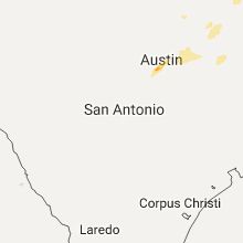
| 5:05 PM CDT | Quarter sized hail reported near Austin, TX, 51.6 miles S of Killeen, TX, time estimated with radar. |
| 5:07 PM CDT | Quarter sized hail reported near Austin, TX, 51.6 miles S of Killeen, TX, corrected time. time estimated with radar. |
| 5:15 PM CDT | Quarter sized hail reported near Austin, TX, 51.5 miles S of Killeen, TX, quarter sized hail... mesa dr at paintrock dr. |
| 5:15 PM CDT | Ping Pong Ball sized hail reported near Austin, TX, 51.6 miles S of Killeen, TX, ping pong ball sized hail near tx 360 at lakewood dr. |
| 5:24 PM CDT | Ping Pong Ball sized hail reported near Austin, TX, 47.3 miles S of Killeen, TX, report and picture from twitter user. no street references available. |
| 5:27 PM CDT | Quarter sized hail reported near Calvert, TX, 64.6 miles E of Killeen, TX, social media report: nickel to quarter size hail report in calvert |
| 5:32 PM CDT | Quarter sized hail reported near Round Rock, TX, 44 miles S of Killeen, TX, quarter sized hail near i-35 at toll road 45. |
| 6:00 PM CDT | Delayed report: major wind damage report just se of groesbeck... near lcr 800 in limestone county TX, 81.4 miles ENE of Killeen, TX |
| 6:00 PM CDT | Delayed report: wind damage report near hw 164 and fm 39. damaged fence... 6-8 inches tree limbs down and one fell on a barn damaging the structure in limestone county TX, 76.9 miles ENE of Killeen, TX |
| 6:25 PM CDT | Power lines down in warren cit in gregg county TX, 67.3 miles W of Shreveport, LA |
| 6:30 PM CDT | Roof off of a churc in gregg county TX, 65.1 miles W of Shreveport, LA |
| 6:52 PM CDT | Quarter sized hail reported near Tyler, TX, 81.6 miles NNW of Lufkin, TX, quarter size hail 1/2 mile north of interstate 20 on hwy 155. |
| 7:00 PM CDT | Trees and powerlines down around minde in rusk county TX, 46 miles N of Lufkin, TX |
| 7:00 PM CDT | Delayed report: wind damage report: a sign and one power line down between buffalo and centerville in leon county TX, 77 miles W of Lufkin, TX |
| 7:02 PM CDT | 2 east of minden... trees are dow in rusk county TX, 46.7 miles N of Lufkin, TX |
| 7:05 PM CDT | Sheriff reports trees down across fm road 851 near alto schoo in cherokee county TX, 30.2 miles NW of Lufkin, TX |
| 7:10 PM CDT | Tree down on a house along county road 362 in east rusk count in rusk county TX, 51.6 miles N of Lufkin, TX |
| 7:40 PM CDT | Emc updated...3 homes with minor damage from trees falling. small branches down across town. powerlines dow in houston county TX, 43.9 miles W of Lufkin, TX |
| 7:45 PM CDT | Sheriff office reports trees down near the intersection of county road 2107 and fm road 124 in cherokee county TX, 42.7 miles NW of Lufkin, TX |
| 8:05 PM CDT | Sheriff reports trees down near st. thomas church on texas hwy 2 in cherokee county TX, 30.5 miles NW of Lufkin, TX |
| 8:18 PM CDT | Tree across road on fm 1087 hundreds yards east of hwy 25 in nacogdoches county TX, 33 miles N of Lufkin, TX |
| 8:30 PM CDT | Several trees down south of sulphur springs near cr 1116 off of hwy 19 in hopkins county TX, 67.1 miles ENE of Dallas, TX |
| 8:36 PM CDT | Damage to bank in garrison. several trees down in the area to in nacogdoches county TX, 36.2 miles NNE of Lufkin, TX |
| 8:38 PM CDT | Large tree down across us 59 with power lines and some meta in nacogdoches county TX, 37.1 miles NNE of Lufkin, TX |
| 8:50 PM CDT | Sheriff reports trees down across n. 2nd street blocking one lan in shelby county TX, 43.4 miles NNE of Lufkin, TX |
| 8:50 PM CDT | Sheriff reports trees down on fm road 415 just off state hwy 8 in shelby county TX, 41.5 miles NNE of Lufkin, TX |
Arkansas
| Local Time | Report Details |
|---|---|
| 2:40 PM CDT | Tennis Ball sized hail reported near Alpena, AR, 61.3 miles S of Springfield, MO |
| 3:05 PM CDT | Golf Ball sized hail reported near Omaha, AR, 52.6 miles S of Springfield, MO |
| 3:05 PM CDT | Baseball sized hail reported near Omaha, AR, 52.6 miles S of Springfield, MO |
| 3:20 PM CDT | Half Dollar sized hail reported near Paris, AR, 32.2 miles E of Fort Smith, AR |
| 3:24 PM CDT | Baseball sized hail reported near Magazine, AR, 35.8 miles ESE of Fort Smith, AR, baseball size hail reported west of paris... ar |
| 3:32 PM CDT | Quarter sized hail reported near Oxford, AR, 100.1 miles SSW of Salem, MO |
| 3:55 PM CDT | Quarter sized hail reported near Cave City, AR, 91.8 miles NNE of Little Rock, AR |
| 4:32 PM CDT | Grapefruit sized hail reported near Bull Shoals, AR, 69.5 miles SE of Springfield, MO |
| 4:35 PM CDT | Quarter sized hail reported near Bull Shoals, AR, 68.6 miles SE of Springfield, MO |
| 4:37 PM CDT | Tennis Ball sized hail reported near Bull Shoals, AR, 69.5 miles SE of Springfield, MO |
| 5:11 PM CDT | Quarter sized hail reported near Mountain Home, AR, 77.5 miles SE of Springfield, MO |
| 5:42 PM CDT | Quarter sized hail reported near Jonesboro, AR, 58.7 miles NW of Memphis, TN, 1 inch hail reported on neely road. |
| 6:32 PM CDT | Storm damage reported in washington county AR, 42.1 miles N of Fort Smith, AR |
Kentucky
| Local Time | Report Details |
|---|---|
| 3:45 PM EDT | Golf Ball sized hail reported near Springfield, KY, 34.1 miles SE of Louisville, KY, two reports... |
| 4:30 PM EDT | Quarter sized hail reported near West Liberty, KY, 43.8 miles ENE of Irvine, KY, 1 inch hail 7 se of west liberty at white oak. |
| 5:30 PM EDT | Social media report of treed down across brown roa in rockcastle county KY, 32.7 miles SW of Irvine, KY |
Washington
| Local Time | Report Details |
|---|---|
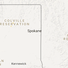
| 3:18 PM PDT | Quarter sized hail reported near Nespelem, WA, 30.6 miles ESE of Omak, WA, trained spotter reported 1 inch hail. |
Virginia
| Local Time | Report Details |
|---|---|
| 7:21 PM EDT | Power line down on staples ave in stuart. time estimated from rada in patrick county VA, 47.4 miles SSW of Roanoke, VA |
| 7:24 PM EDT | Tree down across road in henry county VA, 47.9 miles S of Roanoke, VA |
| 7:28 PM EDT | Tree down across road in henry county VA, 49.4 miles S of Roanoke, VA |
| 7:29 PM EDT | Tree down on horace lane... route 776. time estimated from rada in patrick county VA, 49 miles SSW of Roanoke, VA |
| 8:30 PM EDT | Trees down along old nursery roa in lee county VA, 58 miles W of Bristol, TN |
| 8:30 PM EDT | Trees down near flatwoods road and flanary bridge roa in lee county VA, 54.6 miles W of Bristol, TN |
North Carolina
| Local Time | Report Details |
|---|---|
| 7:28 PM EDT | Tree down on ayers orchard road. time estimated from rada in stokes county NC, 52.4 miles SSW of Roanoke, VA |
| 7:35 PM EDT | A tree was blown down along front stree in rockingham county NC, 53.5 miles SSE of Roanoke, VA |
| 7:35 PM EDT | Quarter sized hail reported near Eden, NC, 53.5 miles SSE of Roanoke, VA |
| 7:35 PM EDT | Three large pine trees were blown down along kingston road...one of which fell against a high voltage power lin in rockingham county NC, 53.9 miles SSE of Roanoke, VA |
| 7:46 PM EDT | Three large trees were blown down along guerrant springs roa in rockingham county NC, 57.9 miles SSE of Roanoke, VA |
| 7:46 PM EDT | Quarter sized hail reported near Ruffin, NC, 57.9 miles SSE of Roanoke, VA |
| 8:15 PM EDT | A tree was blown down blocking high rock school roa in caswell county NC, 57.7 miles NW of Raleigh, NC |
| 9:06 PM EDT | One tree down near the 3200 block of rose of sharon r in durham county NC, 25.2 miles NW of Raleigh, NC |
| 9:08 PM EDT | Emergency management coordinator reported hearing a large tree fall in the wooded area around his hous in durham county NC, 25.9 miles NW of Raleigh, NC |
| 9:11 PM EDT | One tree down near the intersection of cameron blvd and science d in durham county NC, 22.3 miles NW of Raleigh, NC |
| 9:15 PM EDT | One tree down at the 1900 block of angier ave in durha in durham county NC, 18.9 miles NW of Raleigh, NC |
| 9:17 PM EDT | One tree down near the intersection of martin luther king jr blvd and stratford lakes d in durham county NC, 18.4 miles NW of Raleigh, NC |
| 9:28 PM EDT | One tree down blocking the road near the intersection of rock creek rd and timberlane c in wake county NC, 9.4 miles NNW of Raleigh, NC |
| 9:37 PM EDT | One tree down blocking the road near the intersection of durant rd and falls of neuse r in wake county NC, 8.9 miles NNE of Raleigh, NC |
| 9:38 PM EDT | Tree down on power lines at anderson dr. and white oak r in wake county NC, 1.7 miles N of Raleigh, NC |
| 9:39 PM EDT | Trees and powerlines down at jarvis street near cameron village in raleig in wake county NC, 1.1 miles NNW of Raleigh, NC |
| 10:05 PM EDT | One tree down on nc hwy 222 near hwy 23 in johnston county NC, 23.6 miles E of Raleigh, NC |
Tennessee
| Local Time | Report Details |
|---|---|
| 7:13 PM CDT | A large tree is down on craig road off highway 19 west. time is radar estimate in lauderdale county TN, 49.5 miles NNE of Memphis, TN |
| 9:03 PM EDT | Multiple power outages around lafollette according to lafollette utilities. time estimated by rada in campbell county TN, 30.6 miles NNW of Knoxville, TN |
| 8:03 PM CDT | Quarter sized hail reported near Gates, TN, 53.8 miles WSW of Mc Kenzie, TN, quarter size hail at intersection of highways 88 and 209 in gates. |
Louisiana
| Local Time | Report Details |
|---|---|
| 8:15 PM CDT | Sheriff reports trees down on hwy 538 just north of caddo lake bridg in caddo county LA, 18.3 miles NW of Shreveport, LA |
| 8:15 PM CDT | Office lost its rood at caddo lake park in oil cit in caddo county LA, 19.7 miles NW of Shreveport, LA |
Connect with Interactive Hail Maps