

Hail Map for Wednesday, May 10, 2017

Number of Impacted Households on 5/10/2017
0
Impacted by 1" or Larger Hail
0
Impacted by 1.75" or Larger Hail
0
Impacted by 2.5" or Larger Hail
Square Miles of Populated Area Impacted on 5/10/2017
0
Impacted by 1" or Larger Hail
0
Impacted by 1.75" or Larger Hail
0
Impacted by 2.5" or Larger Hail


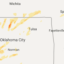


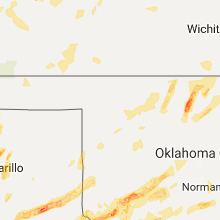


Cities Most Affected by Hail Storms of 5/10/2017
| Hail Size | Demographics of Zip Codes Affected | ||||||
|---|---|---|---|---|---|---|---|
| City | Count | Average | Largest | Pop Density | House Value | Income | Age |
| Memphis, TX | 4 | 1.76 | 1.80 | 8 | $30k | $23.0k | 42.0 |
| Amarillo, TX | 3 | 2.25 | 2.50 | 2071 | $39k | $24.6k | 28.0 |
| Childress, TX | 2 | 2.25 | 2.75 | 7 | $45k | $27.5k | 33.8 |
| Olustee, OK | 2 | 1.88 | 2.00 | 2 | $41k | $27.8k | 35.1 |
| Altus, OK | 2 | 1.75 | 1.75 | 118 | $64k | $30.9k | 33.5 |
| Lakeview, TX | 1 | 2.75 | 2.75 | 1 | $18k | $24.2k | 44.8 |
| Eldorado, OK | 1 | 2.00 | 2.00 | 2 | $33k | $23.2k | 44.4 |
| Stratford, TX | 1 | 1.88 | 1.88 | 0 | $47k | $32.3k | 36.3 |
| Hawley, TX | 1 | 1.75 | 1.75 | 24 | $45k | $37.1k | 40.4 |
| La Junta, CO | 1 | 1.75 | 1.75 | 19 | $69k | $30.5k | 39.2 |
| Winona, KS | 1 | 1.75 | 1.75 | 0 | $32k | $33.1k | 44.1 |
Hail and Wind Damage Spotted on 5/10/2017
Filter by Report Type:Hail ReportsWind Reports
Indiana
| Local Time | Report Details |
|---|---|
| 11:46 AM EDT | Power poles down in downtown. tree damage scattered aroun in johnson county IN, 30.3 miles SSE of Indianapolis, IN |
| 10:25 PM EDT | Car window busted... possibly by tree. time radar estimate in vigo county IN, 51.8 miles E of Mattoon, IL |
| 10:30 PM EDT | Trees dow in vigo county IN, 51.8 miles E of Mattoon, IL |
| 10:37 PM EDT | Estimated wind 60-70 mp in vigo county IN, 53.5 miles E of Mattoon, IL |
| 10:57 PM EDT | Power outage. report via social medi in clay county IN, 53.2 miles WSW of Indianapolis, IN |
| 11:20 PM EDT | Portion of warehouse roof and walls blown down. time estimate in hendricks county IN, 20.7 miles WSW of Indianapolis, IN |
| 11:25 PM EDT | Estimated 60+ mph win in morgan county IN, 27.9 miles SSW of Indianapolis, IN |
| 11:46 PM EDT | Power poles down in downtown. tree damage scattered around. edited to correct tim in johnson county IN, 30.3 miles SSE of Indianapolis, IN |
| 11:47 PM EDT | Trees blocking roa in owen county IN, 40.5 miles SW of Indianapolis, IN |
| 11:50 PM EDT | Trees downe in shelby county IN, 16.8 miles SE of Indianapolis, IN |
| 11:57 PM EDT | Trees downe in shelby county IN, 26.5 miles SE of Indianapolis, IN |
| 12:00 AM EDT | Tree dow in shelby county IN, 26.4 miles ESE of Indianapolis, IN |
| 12:05 AM EDT | Trees and limbs down on roads. power turning off and o in morgan county IN, 34.3 miles SW of Indianapolis, IN |
| 12:22 AM EDT | Good size/ large tree limbs down across tow in decatur county IN, 47.7 miles SE of Indianapolis, IN |
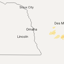
Iowa
| Local Time | Report Details |
|---|---|
| 11:41 AM CDT | Quarter sized hail reported near Orient, IA, 49.3 miles WSW of Des Moines, IA, via social media. |
| 2:27 PM CDT | Quarter sized hail reported near Birmingham, IA, 32.8 miles NNW of Kahoka, MO, delayed report... time estimated |
| 2:30 PM CDT | Quarter sized hail reported near Birmingham, IA, 33.5 miles NNW of Kahoka, MO, couple stones up to quarters. |
| 3:16 PM CDT | Max gusts to 60 mp in van buren county IA, 33.5 miles NNW of Kahoka, MO |
| 4:13 PM CDT | Quarter sized hail reported near New London, IA, 35.8 miles NNE of Kahoka, MO |
Kansas
| Local Time | Report Details |
|---|---|
| 1:56 PM CDT | 10 inch diameter hardwood tree limb broken in johnson county KS, 19.6 miles SW of Kansas City, MO |
| 1:57 PM CDT | 4 inch diameter tree limb snapped in johnson county KS, 18.6 miles SSW of Kansas City, MO |
| 2:00 PM CDT | 8-9 inch silver maple tree diameter snapped in johnson county KS, 18.6 miles SSW of Kansas City, MO |
| 2:04 PM CDT | Large tree uprooted near 151st street in johnson county KS, 16.1 miles SSW of Kansas City, MO |
| 2:06 PM CDT | 4 inch diameter snapped on a healthy hardwood tre in johnson county KS, 17.5 miles SSW of Kansas City, MO |
| 5:20 PM CDT | Delayed report. a 6 to 8 inch diameter tree limb was downed. no estimate on wind speed. time estimated from rada in chautauqua county KS, 55.3 miles SW of Chanute, KS |
| 5:45 PM CDT | Half Dollar sized hail reported near Independence, KS, 42.8 miles SSW of Chanute, KS |
| 6:00 PM CDT | Quarter sized hail reported near Independence, KS, 34.3 miles SSW of Chanute, KS, north edge of independence. |
| 5:01 PM MDT | Quarter sized hail reported near Edson, KS, 32.6 miles WSW of Colby, KS |
| 6:33 PM CDT | Quarter sized hail reported near Colby, KS, 0.9 miles WSW of Colby, KS |
| 6:09 PM MDT | Quarter sized hail reported near Sharon Springs, KS, 58.6 miles SW of Colby, KS, spotter reported quarter sized hail. |
| 7:20 PM CDT | Golf Ball sized hail reported near Winona, KS, 21.5 miles SSW of Colby, KS, hailed for 15-20 minutes...covered the yard...damaged awning |
| 7:34 PM CDT | Quarter sized hail reported near Ashland, KS, 60.8 miles NNW of Woodward, OK |
| 7:38 PM CDT | Quarter sized hail reported near Ashland, KS, 61.8 miles NNW of Woodward, OK, some quarter size. mostly pea size. |
| 7:38 PM CDT | Ping Pong Ball sized hail reported near Ashland, KS, 62 miles NNW of Woodward, OK, marble to walnut/ping pong ball size hail. |
| 10:20 PM CDT | Quarter sized hail reported near Jetmore, KS, 45.4 miles E of Garden City, KS |
| 10:39 PM CDT | Quarter sized hail reported near Grainfield, KS, 39.5 miles SE of Colby, KS, spotter reported quarter sized hail. |
| 11:32 PM CDT | Ping Pong Ball sized hail reported near Grainfield, KS, 39.5 miles SE of Colby, KS, ping pong ball sized hail reported by public via social media. |
| 12:25 AM CDT | Storm damage reported in seward county KS, 53.2 miles S of Garden City, KS |
Missouri
| Local Time | Report Details |
|---|---|
| 2:18 PM CDT | Delayed report...large tree blown over in jackson county MO, 4.2 miles ESE of Kansas City, MO |
| 2:22 PM CDT | 60-65 mph wind gust reporte in jackson county MO, 8.8 miles E of Kansas City, MO |
| 12:30 AM CDT | Quarter sized hail reported near Springfield, MO, 9.1 miles N of Springfield, MO, mping. |
| 12:34 AM CDT | Public report relayed via law enforcement of a 58 mph wind gus in newton county MO, 71.5 miles WSW of Springfield, MO |
| 12:40 AM CDT | A tree around 20ft tall was uprooted and numerous shingles were blown off hous in newton county MO, 65.2 miles WSW of Springfield, MO |
| 12:41 AM CDT | Quarter sized hail reported near Fair Grove, MO, 14.3 miles NNE of Springfield, MO, report relayed by ham radio. |
Texas
| Local Time | Report Details |
|---|---|
| 2:43 PM CDT | Half Dollar sized hail reported near Matador, TX, 43.5 miles WSW of Childress, TX |
| 3:28 PM CDT | Baseball sized hail reported near Childress, TX, 19 miles SW of Childress, TX |
| 4:00 PM CDT | Storm damage reported in cottle county TX, 14.5 miles SE of Childress, TX |
| 4:07 PM CDT | Golf Ball sized hail reported near Childress, TX, 10.3 miles ESE of Childress, TX |
| 4:15 PM CDT | Storm damage reported in hardeman county TX, 16.7 miles ESE of Childress, TX |
| 4:21 PM CDT | Golf Ball sized hail reported near Amarillo, TX, 3 miles NE of Amarillo, TX |
| 4:25 PM CDT | Tennis Ball sized hail reported near Amarillo, TX, 3 miles NE of Amarillo, TX, picture of hail received via facebook. |
| 4:25 PM CDT | Tennis Ball sized hail reported near Amarillo, TX, 3.5 miles NNE of Amarillo, TX, late report on facebook with picture showing tennis ball sized hail. |
| 4:40 PM CDT | Quarter sized hail reported near Quanah, TX, 27 miles E of Childress, TX |
| 4:45 PM CDT | Quarter sized hail reported near Lakeview, TX, 42.4 miles WNW of Childress, TX |
| 4:57 PM CDT | Golf Ball sized hail reported near Stratford, TX, 70.2 miles N of Amarillo, TX, golf ball hail southeast of stratford |
| 4:59 PM CDT | Baseball sized hail reported near Lakeview, TX, 38.7 miles WNW of Childress, TX |
| 5:05 PM CDT | Quarter sized hail reported near Fritch, TX, 32.4 miles NNE of Amarillo, TX |
| 5:28 PM CDT | Golf Ball sized hail reported near Memphis, TX, 28.7 miles NW of Childress, TX |
| 5:28 PM CDT | Quarter sized hail reported near Hedley, TX, 31.1 miles NW of Childress, TX |
| 5:34 PM CDT | Golf Ball sized hail reported near Memphis, TX, 27.9 miles NW of Childress, TX |
| 5:39 PM CDT | Golf Ball sized hail reported near Memphis, TX, 27.9 miles NW of Childress, TX |
| 5:39 PM CDT | Golf Ball sized hail reported near Memphis, TX, 27.9 miles NW of Childress, TX |
| 7:08 PM CDT | Quarter sized hail reported near Odell, TX, 45.8 miles E of Childress, TX |
| 7:09 PM CDT | Quarter sized hail reported near Chillicothe, TX, 39.6 miles ESE of Childress, TX |
| 7:47 PM CDT | Quarter sized hail reported near Laughlin A F B, TX, 6.5 miles E of Del Rio, TX |
| 7:50 PM CDT | Quarter sized hail reported near Del Rio, TX, 5.9 miles E of Del Rio, TX |
| 8:37 PM CDT | Quarter sized hail reported near Abilene, TX, 7 miles W of Abilene, TX |
| 8:55 PM CDT | Quarter sized hail reported near Hawley, TX, 13.1 miles NNW of Abilene, TX, jones county sheriffs office has reported quarter sized hail just north of hawley. |
| 8:58 PM CDT | Quarter sized hail reported near Brackettville, TX, 29.6 miles E of Del Rio, TX |
| 9:00 PM CDT | Golf Ball sized hail reported near Hawley, TX, 11.8 miles NNW of Abilene, TX |
| 10:36 PM CDT | Quarter sized hail reported near Del Rio, TX, 0.8 miles WNW of Del Rio, TX, public report of quarter size hail via twitter observed on the west side of del rio. |
| 11:39 PM CDT | Quarter sized hail reported near Big Lake, TX, 70.6 miles SE of Odessa, TX |
Oklahoma
| Local Time | Report Details |
|---|---|
| 3:09 PM CDT | Quarter sized hail reported near Edmond, OK, 11.6 miles NNE of Oklahoma City, OK, 33rd and bryant |
| 3:11 PM CDT | Quarter sized hail reported near Oklahoma City, OK, 8.7 miles NW of Oklahoma City, OK, 2222nd and macauthur |
| 3:12 PM CDT | Quarter sized hail reported near Oklahoma City, OK, 9.8 miles NNE of Oklahoma City, OK, broadway extension and memorial |
| 4:34 PM CDT | Hen Egg sized hail reported near Eldorado, OK, 28.6 miles E of Childress, TX |
| 5:12 PM CDT | Hen Egg sized hail reported near Olustee, OK, 46.3 miles ENE of Childress, TX |
| 5:14 PM CDT | Golf Ball sized hail reported near Olustee, OK, 45.9 miles E of Childress, TX |
| 5:20 PM CDT | Storm damage reported in jackson county OK, 50.6 miles E of Childress, TX |
| 5:22 PM CDT | Golf Ball sized hail reported near Altus, OK, 51.8 miles ENE of Childress, TX |
| 5:27 PM CDT | Half Dollar sized hail reported near Blair, OK, 55.7 miles ENE of Childress, TX |
| 5:28 PM CDT | Golf Ball sized hail reported near Altus, OK, 52.3 miles ENE of Childress, TX |
| 5:33 PM CDT | Quarter sized hail reported near Altus, OK, 52.7 miles ENE of Childress, TX |
| 5:35 PM CDT | Storm damage reported in jackson county OK, 55.1 miles ENE of Childress, TX |
| 5:35 PM CDT | Half Dollar sized hail reported near Altus, OK, 54.9 miles ENE of Childress, TX |
| 5:40 PM CDT | Ping Pong Ball sized hail reported near Blair, OK, 63.5 miles ENE of Childress, TX |
| 7:20 PM CDT | Quarter sized hail reported near Headrick, OK, 61.7 miles NW of Wichita Falls, TX |
| 7:58 PM CDT | Quarter sized hail reported near Frederick, OK, 44.2 miles NW of Wichita Falls, TX |
| 7:59 PM CDT | Storm damage reported in tillman county OK, 41.1 miles NW of Wichita Falls, TX |
| 8:04 PM CDT | Storm damage reported in tillman county OK, 41.1 miles NW of Wichita Falls, TX |
| 8:24 PM CDT | Storm damage reported in canadian county OK, 24.3 miles WSW of Oklahoma City, OK |
| 9:30 PM CDT | Storm damage reported in payne county OK, 45.3 miles NE of Oklahoma City, OK |
Colorado
| Local Time | Report Details |
|---|---|
| 3:11 PM MDT | Quarter sized hail reported near Rye, CO, 30.3 miles SW of Pueblo, CO |
| 3:49 PM MDT | Quarter sized hail reported near Beulah, CO, 26.2 miles SW of Pueblo, CO, nickle to quarter sized hail. |
| 4:05 PM MDT | Golf Ball sized hail reported near La Junta, CO, 69.7 miles SE of Pueblo, CO, has been falling for the past 30 minutes. |
| 5:30 PM MDT | Half Dollar sized hail reported near Wiley, CO, 101.5 miles W of Garden City, KS |
| 5:57 PM MDT | Quarter sized hail reported near Walsh, CO, 84.1 miles SW of Garden City, KS |
| 6:08 PM MDT | Quarter sized hail reported near Walsh, CO, 87.7 miles WSW of Garden City, KS |
| 6:15 PM MDT | Quarter sized hail reported near Campo, CO, 104.8 miles SW of Garden City, KS |
| 6:15 PM MDT | Half Dollar sized hail reported near Walsh, CO, 85.9 miles WSW of Garden City, KS |
| 6:19 PM MDT | Quarter sized hail reported near Walsh, CO, 87.2 miles WSW of Garden City, KS |
| 6:38 PM MDT | Quarter sized hail reported near Holly, CO, 68.9 miles W of Garden City, KS |
Illinois
| Local Time | Report Details |
|---|---|
| 4:50 PM CDT | Two tall uprooted pine trees at residence near county line along highway 34. time estimated by rada in warren county IL, 57.6 miles ENE of Kahoka, MO |
| 5:07 PM CDT | Large tree limbs blown dow in pike county IL, 56.3 miles SSE of Kahoka, MO |
| 5:35 PM CDT | Tree down on power pole on maple ave near the high school... time esimated on rada in mcdonough county IL, 54.9 miles E of Kahoka, MO |
| 5:45 PM CDT | Tree down on power pole on maple ave near the high school... time esimated on rada in mcdonough county IL, 54.9 miles E of Kahoka, MO |
| 5:46 PM CDT | Tree blown down... onto home roo in mcdonough county IL, 50.1 miles E of Kahoka, MO |
| 5:52 PM CDT | Relayed from e in fulton county IL, 44.2 miles WSW of Peoria, IL |
| 6:15 PM CDT | Multiple trees downe in mason county IL, 36.8 miles SW of Peoria, IL |
| 6:20 PM CDT | Multiple trees downe in mason county IL, 43.5 miles SSW of Peoria, IL |
| 6:25 PM CDT | Trees and power lines downe in morgan county IL, 72.4 miles SW of Peoria, IL |
| 6:28 PM CDT | Multiple trees downe in mason county IL, 25.6 miles SSW of Peoria, IL |
| 6:30 PM CDT | Multiple trees downe in mason county IL, 21.3 miles SSW of Peoria, IL |
| 6:55 PM CDT | Power poles blown down in sangamon county IL, 66.4 miles SSW of Peoria, IL |
| 7:07 PM CDT | 2 trees blown down in town in sangamon county IL, 56.8 miles S of Peoria, IL |
| 7:11 PM CDT | 6 inch tree limb from healthy tree downed near panera bread. relayed by logan county em in sangamon county IL, 63 miles S of Peoria, IL |
| 7:25 PM CDT | Tree downe in sangamon county IL, 65.2 miles S of Peoria, IL |
| 7:25 PM CDT | Tree downe in sangamon county IL, 65.2 miles S of Peoria, IL |
| 7:30 PM CDT | Pushed truck off roadway on pawnee roa in sangamon county IL, 64.9 miles W of Mattoon, IL |
| 7:35 PM CDT | Large tree down at corner of lewis and 2nd street in sangamon county IL, 68.3 miles W of Mattoon, IL |
| 7:42 PM CDT | Medium sized tree branches blown down on some roads in pawnee and blocked a few lanes near il route 10 in sangamon county IL, 64.8 miles W of Mattoon, IL |
| 7:50 PM CDT | Several pine trees snapped near argenta exit from i 72 at mile marker 15 in macon county IL, 40.6 miles NW of Mattoon, IL |
| 8:33 PM CDT | Power line blown dow in douglas county IL, 28.5 miles NNE of Mattoon, IL |
| 8:36 PM CDT | Semi truck rolled over on i 57 at mile marker 19 in coles county IL, 7.4 miles NNE of Mattoon, IL |
| 9:05 PM CDT | Numerous trees uprooted in town. lots of wind damage in paris...trees and powerlines blown dow in edgar county IL, 37.9 miles ENE of Mattoon, IL |
| 9:10 PM CDT | Power lines dow in edgar county IL, 37.9 miles ENE of Mattoon, IL |
Virginia
| Local Time | Report Details |
|---|---|
| 7:44 PM EDT | 2 trees down on police tower road in appomattox county VA, 59.4 miles E of Roanoke, VA |
| 8:00 PM EDT | Quarter sized hail reported near Concord, VA, 53.2 miles E of Roanoke, VA, quarter size hail in concord. time estimated. |
| 8:08 PM EDT | Half Dollar sized hail reported near Concord, VA, 51.9 miles E of Roanoke, VA, quarter to half dollar size hail covering the ground. time from radar. |
| 8:10 PM EDT | Quarter sized hail reported near Concord, VA, 53.2 miles E of Roanoke, VA, mostly nickel size hail but some to quarter size. |
| 9:18 PM EDT | Half Dollar sized hail reported near Clover, VA, 72.2 miles N of Raleigh, NC |
| 9:40 PM EDT | Quarter sized hail reported near Scottsburg, VA, 63.1 miles N of Raleigh, NC, reported via picture on twitter. time radar estimated. |
Connect with Interactive Hail Maps