

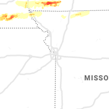
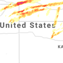
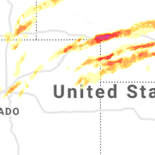
Hail Map for Monday, May 27, 2019

Number of Impacted Households on 5/27/2019
0
Impacted by 1" or Larger Hail
0
Impacted by 1.75" or Larger Hail
0
Impacted by 2.5" or Larger Hail
Square Miles of Populated Area Impacted on 5/27/2019
0
Impacted by 1" or Larger Hail
0
Impacted by 1.75" or Larger Hail
0
Impacted by 2.5" or Larger Hail


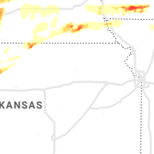

Cities Most Affected by Hail Storms of 5/27/2019
| Hail Size | Demographics of Zip Codes Affected | ||||||
|---|---|---|---|---|---|---|---|
| City | Count | Average | Largest | Pop Density | House Value | Income | Age |
| Champion, NE | 5 | 1.95 | 2.50 | 2 | $35k | $30.3k | 45.6 |
| Big Springs, NE | 5 | 1.90 | 2.50 | 2 | $47k | $29.3k | 49.5 |
| Ogallala, NE | 3 | 1.92 | 2.00 | 30 | $72k | $34.3k | 45.5 |
| Sutherland, NE | 2 | 2.25 | 2.75 | 3 | $74k | $38.9k | 40.6 |
| Holyoke, CO | 2 | 2.13 | 2.50 | 6 | $81k | $32.1k | 41.5 |
| Otterbein, IN | 1 | 4.00 | 4.00 | 23 | $88k | $43.2k | 33.9 |
| Wellfleet, NE | 2 | 1.75 | 1.75 | 1 | $85k | $37.1k | 45.3 |
| Cedarville, OH | 2 | 1.75 | 1.75 | 55 | $120k | $42.5k | 21.7 |
| Fairborn, OH | 2 | 1.75 | 1.75 | 1273 | $97k | $37.7k | 30.3 |
| Enders, NE | 1 | 3.00 | 3.00 | 2 | $43k | $35.0k | 48.8 |
| Brule, NE | 1 | 2.50 | 2.50 | 2 | $52k | $27.0k | 51.6 |
| Plainville, KS | 1 | 2.50 | 2.50 | 8 | $43k | $30.7k | 42.6 |
| Oswego, IL | 1 | 2.00 | 2.00 | 866 | $171k | $70.0k | 34.6 |
| Kearney, NE | 1 | 2.00 | 2.00 | 182 | $89k | $35.1k | 33.5 |
| Paxton, NE | 1 | 2.00 | 2.00 | 2 | $55k | $30.8k | 43.4 |
| Omaha, NE | 1 | 1.75 | 1.75 | 3312 | $120k | $56.3k | 39.1 |
| Marshall, IL | 1 | 1.75 | 1.75 | 44 | $73k | $38.7k | 41.5 |
| Yellow Springs, OH | 1 | 1.75 | 1.75 | 193 | $156k | $54.6k | 48.7 |
| Iliff, CO | 1 | 1.75 | 1.75 | 4 | $57k | $35.7k | 41.0 |
| Ovid, CO | 1 | 1.75 | 1.75 | 1 | $44k | $25.9k | 49.2 |
| Oxford, IN | 1 | 1.75 | 1.75 | 20 | $74k | $41.4k | 41.1 |
| Gothenburg, NE | 1 | 1.75 | 1.75 | 13 | $67k | $36.1k | 40.7 |
| Maywood, NE | 1 | 1.75 | 1.75 | 2 | $53k | $31.5k | 43.6 |
| Willow Island, NE | 1 | 1.75 | 1.75 | 9 | $0k | $0.0k | 56.0 |
Hail and Wind Damage Spotted on 5/27/2019
Filter by Report Type:Hail ReportsWind Reports
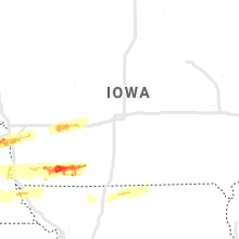
Iowa
| Local Time | Report Details |
|---|---|
| 7:03 AM CDT | Several 3+ inch tree branches broken across beaverdale neighborhood - 2000+ without power delayed repor in polk county IA, 3.1 miles NW of Des Moines, IA |
| 6:19 AM CDT | From a home weather statio in cass county IA, 59.7 miles ENE of Omaha, NE |
| 6:40 AM CDT | 6-8 inch branches down... est 70 mph wind in guthrie county IA, 40.9 miles W of Des Moines, IA |
| 6:48 AM CDT | Storm damage reported in madison county IA, 30.4 miles WSW of Des Moines, IA |
Nebraska
| Local Time | Report Details |
|---|---|
| 8:40 AM CDT | Storm damage reported in burt county NE, 36.6 miles NNW of Omaha, NE |
| 10:04 AM CDT | Ping Pong Ball sized hail reported near Kearney, NE, 40.6 miles WSW of Grand Island, NE, a few to ping pong ball size... but most smaller. |
| 10:44 AM CDT | Detached garage flattened. significant amount of tree limbs dow in nuckolls county NE, 64.1 miles SSE of Grand Island, NE |
| 5:16 PM MDT | Also nickel size hail in deuel county NE, 66.4 miles NNE of Yuma, CO |
| 5:37 PM MDT | Tennis Ball sized hail reported near Big Springs, NE, 68.5 miles W of North Platte, NE |
| 5:49 PM MDT | Golf Ball sized hail reported near Big Springs, NE, 68.5 miles W of North Platte, NE |
| 5:50 PM MDT | Quarter sized hail reported near Big Springs, NE, 66.2 miles W of North Platte, NE |
| 5:50 PM MDT | Golf Ball sized hail reported near Big Springs, NE, 71.6 miles NNE of Yuma, CO, lost some windows with the wind driving the hail into the house |
| 5:55 PM MDT | Golf Ball sized hail reported near Big Springs, NE, 66.2 miles W of North Platte, NE |
| 5:55 PM MDT | Golf Ball sized hail reported near Big Springs, NE, 68.5 miles W of North Platte, NE, correction for time/date hail damaged numerous car windows on interstate 76 from the colorado state line east to big springs. several semi tractor trailers sustained br |
| 6:02 PM MDT | Tennis Ball sized hail reported near Brule, NE, 58.9 miles W of North Platte, NE, mainly golf ball size with a handfull of tennis ball size |
| 6:02 PM MDT | Ping Pong Ball sized hail reported near Brule, NE, 58.9 miles W of North Platte, NE, about a dozen cars in a parking lot had windows broken by the hail |
| 6:13 PM MDT | Quarter sized hail reported near Ogallala, NE, 53.7 miles W of North Platte, NE, hail covers the ground an inch deep with quarter size hail. |
| 6:15 PM MDT | Ping Pong Ball sized hail reported near Ogallala, NE, 53.7 miles W of North Platte, NE, hail up to two inches deep. |
| 6:23 PM MDT | Half Dollar sized hail reported near Ogallala, NE, 49.9 miles W of North Platte, NE |
| 6:25 PM MDT | Half Dollar sized hail reported near Brule, NE, 54.7 miles W of North Platte, NE |
| 6:27 PM MDT | Hen Egg sized hail reported near Ogallala, NE, 49.9 miles W of North Platte, NE |
| 6:30 PM MDT | Hen Egg sized hail reported near Ogallala, NE, 49.9 miles W of North Platte, NE, multiple reports of 2 in. hail. vehicle heavily damaged |
| 6:38 PM MDT | Golf Ball sized hail reported near Champion, NE, 49.3 miles NE of Yuma, CO |
| 6:40 PM MDT | Golf Ball sized hail reported near Champion, NE, 48.8 miles NE of Yuma, CO |
| 6:45 PM MDT | Golf Ball sized hail reported near Ogallala, NE, 42.6 miles W of North Platte, NE, had damage to one window from the hail |
| 6:49 PM MDT | Golf Ball sized hail reported near Champion, NE, 48.5 miles NE of Yuma, CO, hail up to golf ball size covering roads |
| 6:55 PM MDT | Hen Egg sized hail reported near Paxton, NE, 38.5 miles W of North Platte, NE, hail covering the ground. |
| 7:01 PM MDT | Ping Pong Ball sized hail reported near Champion, NE, 48.8 miles NE of Yuma, CO |
| 7:03 PM MDT | Hen Egg sized hail reported near Champion, NE, 48 miles NE of Yuma, CO, also reported fog with visibility of 1/4 mile |
| 7:04 PM MDT | Tennis Ball sized hail reported near Champion, NE, 50.1 miles NE of Yuma, CO |
| 7:22 PM MDT | Storm damage reported in chase county NE, 60.9 miles ENE of Yuma, CO |
| 7:25 PM MDT | Measured with weather station in chase county NE, 60.9 miles ENE of Yuma, CO |
| 7:26 PM MDT | Quarter sized hail reported near Paxton, NE, 28 miles W of North Platte, NE |
| 7:35 PM MDT | Snapped power pole in chase county NE, 60.3 miles SW of North Platte, NE |
| 8:37 PM CDT | Quarter sized hail reported near Sutherland, NE, 25.8 miles W of North Platte, NE, hail covered the ground with half inch to quarter size hail. |
| 8:43 PM CDT | Golf Ball sized hail reported near Sutherland, NE, 19.2 miles W of North Platte, NE, hail covering the street |
| 8:45 PM CDT | Baseball sized hail reported near Sutherland, NE, 19.2 miles W of North Platte, NE, golf ball to baseball size hail |
| 9:29 PM CDT | Quarter sized hail reported near Wilcox, NE, 58 miles SW of Grand Island, NE |
| 9:29 PM CDT | Quarter sized hail reported near Wallace, NE, 30.5 miles SW of North Platte, NE |
| 8:35 PM MDT | Quarter sized hail reported near Champion, NE, 56.8 miles ENE of Yuma, CO |
| 9:53 PM CDT | Golf Ball sized hail reported near Wellfleet, NE, 22 miles SSW of North Platte, NE |
| 8:55 PM MDT | Tea Cup sized hail reported near Enders, NE, 61.3 miles SW of North Platte, NE, correction |
| 9:59 PM CDT | Half Dollar sized hail reported near Kearney, NE, 40.6 miles WSW of Grand Island, NE |
| 10:00 PM CDT | Hen Egg sized hail reported near Kearney, NE, 40.6 miles WSW of Grand Island, NE, via facebook photo. |
| 10:02 PM CDT | Quarter sized hail reported near Kearney, NE, 42.3 miles WSW of Grand Island, NE |
| 10:05 PM CDT | Golf Ball sized hail reported near Wellfleet, NE, 20.5 miles S of North Platte, NE |
| 9:05 PM MDT | Ping Pong Ball sized hail reported near Wauneta, NE, 62.4 miles SW of North Platte, NE |
| 10:05 PM CDT | Quarter sized hail reported near Kearney, NE, 41.5 miles WSW of Grand Island, NE |
| 10:07 PM CDT | Half Dollar sized hail reported near Stapleton, NE, 19.6 miles NE of North Platte, NE, hail up to half dollar size fell. |
| 10:10 PM CDT | Ping Pong Ball sized hail reported near Wellfleet, NE, 23.9 miles S of North Platte, NE |
| 10:44 PM CDT | Corrects previous tstm wnd dmg report from superior for time. detached garage flattened. significant amount of tree limbs dow in nuckolls county NE, 64.1 miles SSE of Grand Island, NE |
| 10:59 PM CDT | Quarter sized hail reported near Gothenburg, NE, 34.6 miles ESE of North Platte, NE |
| 11:00 PM CDT | Golf Ball sized hail reported near Gothenburg, NE, 34.1 miles ESE of North Platte, NE, up to golf ball size... most smaller. |
| 11:05 PM CDT | Gust to 60 mph via asos 05039g52kt in custer county NE, 61.4 miles ENE of North Platte, NE |
| 11:08 PM CDT | Storm damage reported in custer county NE, 61.4 miles ENE of North Platte, NE |
| 11:10 PM CDT | Quarter sized hail reported near Merna, NE, 54.5 miles ENE of North Platte, NE |
| 11:20 PM CDT | Golf Ball sized hail reported near Willow Island, NE, 40 miles ESE of North Platte, NE |
| 11:25 PM CDT | Golf Ball sized hail reported near Maywood, NE, 33.7 miles SSE of North Platte, NE, frontier county sheriff office |
| 11:25 PM CDT | Frontier county sheriff office estimated wind gusts in frontier county NE, 33.7 miles SSE of North Platte, NE |
| 11:29 PM CDT | Storm damage reported in thayer county NE, 58.3 miles SE of Grand Island, NE |
| 11:30 PM CDT | Delayed report from a few hours ago...personal weather statio in dawson county NE, 44.9 miles ESE of North Platte, NE |
| 12:12 AM CDT | Quarter sized hail reported near Miller, NE, 55 miles W of Grand Island, NE |
| 12:48 AM CDT | Quarter sized hail reported near Pickrell, NE, 73.5 miles SW of Omaha, NE |
| 12:58 AM CDT | Quarter sized hail reported near Ravenna, NE, 30.7 miles WNW of Grand Island, NE |
| 1:25 AM CDT | Quarter sized hail reported near Sterling, NE, 59.1 miles SSW of Omaha, NE, corrects previous hail report from 2 e sterling. |
| 4:15 AM CDT | Quarter sized hail reported near Elkhorn, NE, 16.7 miles WSW of Omaha, NE |
| 4:15 AM CDT | Half Dollar sized hail reported near Gretna, NE, 17.1 miles WSW of Omaha, NE |
| 4:15 AM CDT | Storm damage reported in douglas county NE, 16.7 miles WSW of Omaha, NE |
| 4:20 AM CDT | Quarter sized hail reported near Omaha, NE, 14.9 miles WSW of Omaha, NE |
| 4:30 AM CDT | Golf Ball sized hail reported near Omaha, NE, 8.6 miles WSW of Omaha, NE, 10 minutes of golf ball hail near 120th and center. |
| 4:31 AM CDT | Quarter sized hail reported near Omaha, NE, 5.7 miles W of Omaha, NE |
| 4:34 AM CDT | Quarter sized hail reported near Omaha, NE, 3.5 miles SW of Omaha, NE, near 42nd and i-80. |
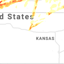
Kansas
| Local Time | Report Details |
|---|---|
| 8:43 AM CDT | Report of a few power lines down in frontena in crawford county KS, 44.5 miles ESE of Chanute, KS |
| 7:49 PM CDT | Half Dollar sized hail reported near Plainville, KS, 19.3 miles NNW of Hays, KS |
| 7:56 PM CDT | Tennis Ball sized hail reported near Plainville, KS, 26.1 miles NNW of Hays, KS, report from twitter. |
Missouri
| Local Time | Report Details |
|---|---|
| 9:13 AM CDT | Corrects previous tstm wnd dmg report from 3 wnw dunnegan. report of a few large trees branches broke near county road 240 in cedar county MO, 40.5 miles NNW of Springfield, MO |
| 10:13 AM CDT | Report of a few large trees branches broke near county road 240 in cedar county MO, 40.5 miles NNW of Springfield, MO |
Ohio
| Local Time | Report Details |
|---|---|
| 11:15 AM EDT | Golf Ball sized hail reported near Fairborn, OH, 54.3 miles WSW of Columbus, OH |
| 11:31 AM EDT | Golf Ball sized hail reported near Cedarville, OH, 45.6 miles WSW of Columbus, OH |
| 4:58 PM EDT | Tree down in monroe on britton lane between oh-63 and ohio avenu in butler county OH, 24.3 miles NNE of Cincinnati, OH |
| 5:07 PM EDT | Trees reported down at trails at shaker run. time estimated from rada in warren county OH, 27 miles NNE of Cincinnati, OH |
| 5:15 PM EDT | Storm damage reported in warren county OH, 27.9 miles NNE of Cincinnati, OH |
| 10:05 PM EDT | Building at ohio 121 and 72 with door blown off. damage possibly caused by a tornad in darke county OH, 60.6 miles N of Cincinnati, OH |
| 10:09 PM EDT | Tree down on house. many power lines and trees down over roads in area. damage possibly caused by a tornad in mercer county OH, 44.5 miles SE of Fort Wayne, IN |
| 10:17 PM EDT | Trees and power lines down... possibly caused by a tornad in darke county OH, 60.6 miles N of Cincinnati, OH |
| 10:28 PM EDT | Quarter sized hail reported near Arcanum, OH, 56.8 miles N of Cincinnati, OH, time estimated from radar data |
| 10:58 PM EDT | Numerous trees down union road and state route 49 in clayton. possible tornad in montgomery county OH, 52.2 miles N of Cincinnati, OH |
| 11:11 PM EDT | Quarter sized hail reported near Dayton, OH, 56.1 miles NNE of Cincinnati, OH |
| 11:12 PM EDT | Numerous large trees downed and some structural damage near smithville road and east 3rd. st. possible tornad in montgomery county OH, 49.7 miles NNE of Cincinnati, OH |
| 11:14 PM EDT | Quarter sized hail reported near Dayton, OH, 56.1 miles NNE of Cincinnati, OH |
| 11:15 PM EDT | Golf Ball sized hail reported near Fairborn, OH, 54.3 miles WSW of Columbus, OH |
| 11:27 PM EDT | Possible tornado. porch blown off house. time estimated from rada in greene county OH, 52.8 miles NNE of Cincinnati, OH |
| 11:29 PM EDT | Golf Ball sized hail reported near Yellow Springs, OH, 48.3 miles WSW of Columbus, OH |
| 11:30 PM EDT | Large tree dow in montgomery county OH, 54.9 miles NNE of Cincinnati, OH |
| 11:31 PM EDT | Golf Ball sized hail reported near Cedarville, OH, 45.6 miles WSW of Columbus, OH |
| 11:55 PM EDT | Muliple tree limbs dow in greene county OH, 49.1 miles NNE of Cincinnati, OH |
| 12:30 AM EDT | Half Dollar sized hail reported near Dayton, OH, 49.1 miles NNE of Cincinnati, OH, first report of penny hail 5/27 2312 hours. next round of quarter to half dollar at 0030 5/28. |
| 1:19 AM EDT | Significant damage to structures near laurelville... including on union rd. time estimated. possible tornad in hocking county OH, 33.4 miles SSE of Columbus, OH |
| 1:30 AM EDT | Multiple reports of trees and power lines down in the city of roseville. village is impassable... route 93 is closed due to downed tree in perry county OH, 50.7 miles ESE of Columbus, OH |
| 1:35 AM EDT | *** 1 inj *** numerous trees down...power lines down...damage to multiple home in muskingum county OH, 50.7 miles ESE of Columbus, OH |
Illinois
| Local Time | Report Details |
|---|---|
| 1:21 PM CDT | Quarter sized hail reported near Somonauk, IL, 55.5 miles WSW of Chicago, IL, corrects previous hail report from 1.9 ne somonauk for time. |
| 1:44 PM CDT | Ping Pong Ball sized hail reported near Naperville, IL, 27.9 miles WSW of Chicago, IL, flooding 1 foot near naperville road. |
| 1:45 PM CDT | 6ft diameter tree uprooted. time estimated by rada in kendall county IL, 45 miles WSW of Chicago, IL |
| 1:50 PM CDT | Quarter sized hail reported near Aurora, IL, 36 miles WSW of Chicago, IL |
| 1:55 PM CDT | Quarter sized hail reported near Aurora, IL, 36 miles WSW of Chicago, IL |
| 1:55 PM CDT | Hen Egg sized hail reported near Oswego, IL, 40.1 miles WSW of Chicago, IL, multiple reports of hail to 2 in owsego. winds to 60 mph. |
| 2:03 PM CDT | Quarter sized hail reported near Plainfield, IL, 35.3 miles WSW of Chicago, IL |
| 2:07 PM CDT | Quarter sized hail reported near Naperville, IL, 28.5 miles WSW of Chicago, IL, 95th and naperville plainfield road in south napeville. |
| 2:08 PM CDT | Storm damage reported in will county IL, 25.9 miles WSW of Chicago, IL |
| 2:09 PM CDT | Half Dollar sized hail reported near Bolingbrook, IL, 25.9 miles WSW of Chicago, IL |
| 2:10 PM CDT | Ping Pong Ball sized hail reported near Bolingbrook, IL, 25.9 miles WSW of Chicago, IL |
| 2:10 PM CDT | Tree uprooted along renwick road. time estimated by rada in will county IL, 33.6 miles SW of Chicago, IL |
| 2:11 PM CDT | Quarter sized hail reported near Romeoville, IL, 28.6 miles SW of Chicago, IL |
| 2:13 PM CDT | Half Dollar sized hail reported near Romeoville, IL, 28.6 miles SW of Chicago, IL, highest gust to 48 mph at nws in romeovile... il. |
| 2:15 PM CDT | Quarter sized hail reported near Bolingbrook, IL, 29 miles WSW of Chicago, IL, time estimated by radar. |
| 2:16 PM CDT | Quarter sized hail reported near Bolingbrook, IL, 25.9 miles WSW of Chicago, IL |
| 2:35 PM CDT | Delayed report. a section of a tree snapped off and fell onto a house approximately at 8600 block of w 145th street. time is estimated by radar and em report to have oc in cook county IL, 20.3 miles SSW of Chicago, IL |
| 2:45 PM CDT | Broadcast media shared picture of gas station canopy blow off in alsip. exact location unknown. time estimated by rada in cook county IL, 15.6 miles SSW of Chicago, IL |
| 2:45 PM CDT | Tree uprooted... numerous branches down in the area making roadways near impassable. time estimated by rada in cook county IL, 22.9 miles SW of Chicago, IL |
| 2:45 PM CDT | Quarter sized hail reported near Lemont, IL, 22.9 miles SW of Chicago, IL, hail of at least 1.0in size... possibly up to 1.5in size. time estimated by radar. |
| 2:46 PM CDT | Reports of numerous trees and power lines down near and around the 19th ward. relayed by chicago oemc and time estimated based on rada in cook county IL, 11.4 miles SSW of Chicago, IL |
| 4:06 PM CDT | Ping Pong Ball sized hail reported near Steger, IL, 28.6 miles S of Chicago, IL |
| 4:09 PM CDT | Half Dollar sized hail reported near Park Forest, IL, 28 miles S of Chicago, IL |
| 4:10 PM CDT | Quarter sized hail reported near Somonauk, IL, 55.5 miles WSW of Chicago, IL |
| 4:10 PM CDT | Trees and limbs dow in lee county IL, 68 miles NNE of Peoria, IL |
| 4:15 PM CDT | Roof blown off a building on park avenue. time estimated. possible tornado damag in cook county IL, 28.6 miles S of Chicago, IL |
| 4:30 PM CDT | Corrects previous tstm wnd dmg report from amboy for time. trees and limbs dow in lee county IL, 71.5 miles N of Peoria, IL |
| 5:05 PM CDT | Golf Ball sized hail reported near Marshall, IL, 38 miles ESE of Mattoon, IL, reported near lincoln trail state park |
| 5:53 PM CDT | Delayed report relayed via social media from 2 separate spotter reports. two snapped evergreens blocking il-49 between crescent city and cissna park. time estimated by in iroquois county IL, 84.1 miles NNE of Mattoon, IL |
Colorado
| Local Time | Report Details |
|---|---|
| 1:00 PM MDT | Quarter sized hail reported near Bennett, CO, 25.1 miles E of Denver, CO |
| 1:13 PM MDT | Quarter sized hail reported near Watkins, CO, 23.5 miles E of Denver, CO, report via twitter. |
| 1:52 PM MDT | Quarter sized hail reported near Strasburg, CO, 38.2 miles ENE of Denver, CO |
| 2:24 PM MDT | Quarter sized hail reported near Wiggins, CO, 63.6 miles NE of Denver, CO |
| 2:35 PM MDT | Quarter sized hail reported near Wiggins, CO, 59.5 miles NE of Denver, CO, hail ranging in size from peas to quarters measured 3 inches deep in the town of wiggins. |
| 2:42 PM MDT | Half Dollar sized hail reported near Wiggins, CO, 59.5 miles NE of Denver, CO |
| 3:34 PM MDT | Quarter sized hail reported near Sterling, CO, 50.6 miles NW of Yuma, CO |
| 4:13 PM MDT | Golf Ball sized hail reported near Iliff, CO, 47.9 miles NNW of Yuma, CO, hail accumulating to 3 inched deep in town. minor localized flooding of streets and fields. significant damage to vegetation in and around iliff. |
| 4:42 PM MDT | Quarter sized hail reported near Crook, CO, 51.4 miles N of Yuma, CO |
| 4:57 PM MDT | Quarter sized hail reported near Brighton, CO, 26.4 miles NNE of Denver, CO |
| 5:11 PM MDT | Golf Ball sized hail reported near Ovid, CO, 59.8 miles NNE of Yuma, CO, torrential rain. |
| 5:25 PM MDT | Quarter sized hail reported near Julesburg, CO, 64.7 miles NNE of Yuma, CO |
| 5:27 PM MDT | Quarter sized hail reported near Greeley, CO, 49.5 miles NNE of Denver, CO |
| 5:40 PM MDT | Quarter sized hail reported near Yuma, CO, 18.8 miles NNE of Yuma, CO |
| 5:53 PM MDT | Quarter sized hail reported near Haxtun, CO, 23.2 miles NNE of Yuma, CO |
| 5:58 PM MDT | Quarter sized hail reported near Holyoke, CO, 26.8 miles NNE of Yuma, CO |
| 6:10 PM MDT | Quarter sized hail reported near Holyoke, CO, 40.5 miles NE of Yuma, CO |
| 6:23 PM MDT | Golf Ball sized hail reported near Holyoke, CO, 42.9 miles NE of Yuma, CO |
| 6:30 PM MDT | Tennis Ball sized hail reported near Holyoke, CO, 44.2 miles NE of Yuma, CO |
| 7:00 PM MDT | Quarter sized hail reported near Yuma, CO, 4.3 miles SE of Yuma, CO, quarter size hail reported 3 miles east and 2 miles south of yuma at 7 pm mdt. |
| 8:02 PM MDT | Quarter sized hail reported near Wray, CO, 35.7 miles ENE of Yuma, CO |
| 10:30 PM MDT | Quarter sized hail reported near Yuma, CO, 0.2 miles ENE of Yuma, CO |
| 1:20 AM MDT | Half Dollar sized hail reported near Denver, CO, 4.5 miles SSE of Denver, CO |
| 1:52 AM MDT | Quarter sized hail reported near Denver, CO, 18.1 miles ENE of Denver, CO |
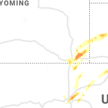
Wyoming
| Local Time | Report Details |
|---|---|
| 1:25 PM MDT | Quarter sized hail reported near Cheyenne, WY, 43.1 miles ESE of Laramie, WY, on hot springs avenue just south of the hospital. |
| 2:55 PM MDT | Quarter sized hail reported near Cheyenne, WY, 39.6 miles ESE of Laramie, WY |
| 3:00 PM MDT | Quarter sized hail reported near Cheyenne, WY, 44.2 miles ESE of Laramie, WY |
| 3:30 PM MDT | Quarter sized hail reported near Cheyenne, WY, 52.8 miles ESE of Laramie, WY, reported from near mile maker 371 on i-80 at the port of entry. |
| 4:00 PM MDT | Quarter sized hail reported near Lagrange, WY, 42.2 miles WSW of Scottsbluff, NE |
| 4:03 PM MDT | Ping Pong Ball sized hail reported near Burns, WY, 58.5 miles SW of Scottsbluff, NE |
| 4:04 PM MDT | Quarter sized hail reported near Lagrange, WY, 42.2 miles WSW of Scottsbluff, NE |
| 4:10 PM MDT | Quarter sized hail reported near Burns, WY, 57.9 miles SW of Scottsbluff, NE |
Indiana
| Local Time | Report Details |
|---|---|
| 3:55 PM EDT | Corrects previous tstm wnd dmg report from 4 sse mccordsville. corrects previous non-tstm wnd gst report from 4 sse mccordsville. awos station kmqj indianapolis re in hancock county IN, 14.5 miles ENE of Indianapolis, IN |
| 3:55 PM EDT | Corrects previous tstm wnd dmg report from 4 sse mccordsville. corrects previous non-tstm wnd gst report from 4 sse mccordsville. awos station kmqj indianapolis re in hancock county IN, 14.5 miles ENE of Indianapolis, IN |
| 4:00 PM EDT | Power pole lines down near intersection of state road 67 and county road 900s. time estimated from rada in madison county IN, 24.6 miles NE of Indianapolis, IN |
| 4:10 PM EDT | A few trees down in southern madison count in madison county IN, 24.6 miles NE of Indianapolis, IN |
| 4:12 PM CDT | Quarter sized hail reported near Michigan City, IN, 39.7 miles ESE of Chicago, IL |
| 5:15 PM EDT | Half Dollar sized hail reported near Andrews, IN, 35.8 miles SW of Fort Wayne, IN |
| 4:30 PM CDT | Tree damage and shed damage reported near scotty lane and heart street. time estimate in lake county IN, 28.5 miles SSE of Chicago, IL |
| 6:13 PM EDT | Multiple branches down 3 to 4 inches in diamete in st. joseph county IN, 70.2 miles ESE of Chicago, IL |
| 5:20 PM CDT | Ping Pong Ball sized hail reported near Valparaiso, IN, 41.2 miles SE of Chicago, IL |
| 7:05 PM EDT | Trees on powerline in st. joseph county IN, 66.8 miles ESE of Chicago, IL |
| 7:12 PM EDT | Numerous 3-4 in diameter tree branches dow in st. joseph county IN, 70 miles ESE of Chicago, IL |
| 7:18 PM EDT | Power poles down near n800w and w600n. time estimated by rada in benton county IN, 82.8 miles S of Chicago, IL |
| 7:20 PM EDT | Quarter sized hail reported near Logansport, IN, 71.4 miles NNW of Indianapolis, IN |
| 7:41 PM EDT | Quarter sized hail reported near Oxford, IN, 79.5 miles NW of Indianapolis, IN, near benton central high school. time estimated based on radar. |
| 7:41 PM EDT | Reports of tree damage near benton central hs relayed by media. time estimated based on rada in benton county IN, 79.5 miles NW of Indianapolis, IN |
| 7:44 PM EDT | Measured gusts at a personal weather station. additional measured 70 mph wind gusts in otterbei in benton county IN, 82.1 miles NW of Indianapolis, IN |
| 7:46 PM EDT | Golf Ball sized hail reported near Oxford, IN, 78.1 miles NW of Indianapolis, IN |
| 7:58 PM EDT | Storm damage reported in tippecanoe county IN, 71.4 miles NW of Indianapolis, IN |
| 8:00 PM EDT | Power poles down in otterbein. relayed by media and time estimated based on rada in benton county IN, 70.9 miles NW of Indianapolis, IN |
| 8:00 PM EDT | Grapefruit sized hail reported near Otterbein, IN, 70.5 miles NW of Indianapolis, IN |
| 8:10 PM EDT | Quarter sized hail reported near Lapel, IN, 26.6 miles NE of Indianapolis, IN |
| 8:10 PM EDT | Ema reports 75 homes damaged in pendleton... possibly caused by tornado. nws survey pending. time estimate in madison county IN, 27.5 miles NE of Indianapolis, IN |
| 8:13 PM EDT | Storm damage reported in madison county IN, 27.1 miles NE of Indianapolis, IN |
| 8:13 PM EDT | Storm damage reported in tippecanoe county IN, 63 miles NW of Indianapolis, IN |
| 8:21 PM EDT | Roofs off of homes and power lines down. possible tornado damag in madison county IN, 27.9 miles NE of Indianapolis, IN |
| 8:30 PM EDT | Ping Pong Ball sized hail reported near La Fontaine, IN, 42.5 miles SW of Fort Wayne, IN, picture from social media. |
| 8:31 PM EDT | Large tree branches down and pea size hail also reporte in tippecanoe county IN, 50.8 miles NW of Indianapolis, IN |
| 8:40 PM EDT | Quarter sized hail reported near Huntington, IN, 27.1 miles SW of Fort Wayne, IN |
| 8:40 PM EDT | Power lines and trees down. major barn damage in the area. time radar estimate in henry county IN, 42.5 miles ENE of Indianapolis, IN |
| 8:40 PM EDT | Several 3 foot trees dow in henry county IN, 38.7 miles ENE of Indianapolis, IN |
| 8:40 PM EDT | Numerous trees and limbs down along state route 67 southwest of muncie. a few tree limbs sticking straight up out of the groun in delaware county IN, 44.8 miles NE of Indianapolis, IN |
| 9:03 PM EDT | Tree down on power lines 2-3 miles east of orlan in steuben county IN, 45.9 miles N of Fort Wayne, IN |
| 9:33 PM EDT | Quarter sized hail reported near Fountain City, IN, 64.4 miles NNW of Cincinnati, OH, time estimated from radar. |
| 9:39 PM EDT | Quarter sized hail reported near Lynn, IN, 66.5 miles ENE of Indianapolis, IN |
Connect with Interactive Hail Maps