

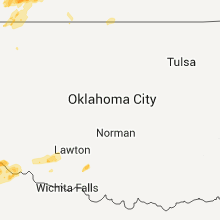
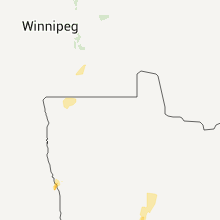
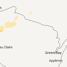
Hail Map for Monday, May 30, 2011

Number of Impacted Households on 5/30/2011
0
Impacted by 1" or Larger Hail
0
Impacted by 1.75" or Larger Hail
0
Impacted by 2.5" or Larger Hail
Square Miles of Populated Area Impacted on 5/30/2011
0
Impacted by 1" or Larger Hail
0
Impacted by 1.75" or Larger Hail
0
Impacted by 2.5" or Larger Hail


Cities Most Affected by Hail Storms of 5/30/2011
| Hail Size | Demographics of Zip Codes Affected | ||||||
|---|---|---|---|---|---|---|---|
| City | Count | Average | Largest | Pop Density | House Value | Income | Age |
| Atkinson, NE | 7 | 2.71 | 4.00 | 2 | $52k | $30.6k | 47.1 |
| Taylor, NE | 2 | 2.50 | 2.50 | 1 | $20k | $26.7k | 46.6 |
| Stuart, NE | 2 | 2.25 | 2.75 | 2 | $53k | $30.7k | 47.1 |
| Bassett, NE | 1 | 2.75 | 2.75 | 1 | $41k | $25.5k | 50.4 |
| Newport, NE | 1 | 2.75 | 2.75 | 1 | $15k | $32.7k | 50.8 |
| Red Wing, MN | 1 | 2.00 | 2.00 | 157 | $116k | $45.2k | 42.5 |
| Salem, SD | 1 | 1.75 | 1.75 | 8 | $65k | $36.7k | 43.9 |
| Matador, TX | 1 | 1.75 | 1.75 | 0 | $31k | $28.6k | 46.9 |
| Moriarty, NM | 1 | 1.75 | 1.75 | 11 | $91k | $30.3k | 39.2 |
| Parkston, SD | 1 | 1.75 | 1.75 | 6 | $54k | $31.1k | 45.8 |
| Crosbyton, TX | 1 | 1.75 | 1.75 | 6 | $36k | $24.7k | 41.2 |
| Tell, TX | 1 | 1.75 | 1.75 | 0 | $25k | $16.3k | 52.3 |
| Armour, SD | 1 | 1.75 | 1.75 | 3 | $38k | $30.4k | 50.5 |
| Henderson, MN | 1 | 1.75 | 1.75 | 18 | $91k | $47.0k | 41.3 |
Hail and Wind Damage Spotted on 5/30/2011
Filter by Report Type:Hail ReportsWind Reports
States Impacted
Minnesota, Michigan, Wisconsin, Colorado, Nebraska, South Dakota, Kansas, New Mexico, North Dakota, Texas, Iowa, Oklahoma, MissouriMinnesota
| Local Time | Report Details |
|---|---|
| 1:54 PM UTC | Half Dollar sized hail reported near Richfield, MN, 6.9 miles S of Minneapolis, MN, mostly small hail. one peice was roughly this size. |
| 2:52 PM UTC | Golf Ball sized hail reported near Henderson, MN, 44.4 miles SW of Minneapolis, MN |
| 3:01 PM UTC | Quarter sized hail reported near Richfield, MN, 6.2 miles S of Minneapolis, MN |
| 3:26 PM UTC | Quarter sized hail reported near White Bear Lake, MN, 14 miles ENE of Minneapolis, MN |
| 5:40 PM UTC | Hen Egg sized hail reported near Red Wing, MN, 45.6 miles SE of Minneapolis, MN |
| 1:40 AM UTC | Trees down and power outage in lac qui parle county MN, 23.5 miles W of Montevideo, MN |
| 1:50 AM UTC | Storm damage reported in stevens county MN, 48.1 miles NNW of Montevideo, MN |
| 1:50 AM UTC | Door off machine she in stevens county MN, 51.2 miles NNW of Montevideo, MN |
| 1:57 AM UTC | Dilworth rwis recorded wind gust of 60 mp in clay county MN, 3.9 miles E of Fargo, ND |
| 2:00 AM UTC | Semi-truck rolled over due to possible thunderstorm winds at mile marker 6 on interstate 9 in clay county MN, 1.5 miles SE of Fargo, ND |
| 2:00 AM UTC | Semi-truck rolled over due to possible thundstorm winds at mile marker in clay county MN, 1.5 miles SE of Fargo, ND |
| 2:00 AM UTC | Semi-truck rolled over due to possible thundstorm wind in clay county MN, 1.5 miles SE of Fargo, ND |
| 2:26 AM UTC | Ada ndawn in norman county MN, 33.9 miles NNE of Fargo, ND |
| 2:30 AM UTC | Report of trees down in halsta in norman county MN, 32.8 miles N of Fargo, ND |
| 2:48 AM UTC | Eldred ndawn in polk county MN, 55.6 miles N of Fargo, ND |
| 2:52 AM UTC | Storm damage reported in douglas county MN, 70.6 miles N of Montevideo, MN |
| 3:00 AM UTC | Storm damage reported in polk county MN, 63.8 miles N of Fargo, ND |
| 3:00 AM UTC | Many reports of damage across the city...powerlines down...trees down...and street signs blown ove in polk county MN, 62.3 miles N of Fargo, ND |
| 3:00 AM UTC | Roof blown off buildin in otter tail county MN, 65.8 miles ESE of Fargo, ND |
| 3:05 AM UTC | Medium to large tree branches down in city of crooksto in polk county MN, 62.3 miles N of Fargo, ND |
| 3:05 AM UTC | Reports of power poles down...big trees down...and a shed possibly destroye in polk county MN, 62.3 miles N of Fargo, ND |
| 3:35 AM UTC | Report of down tree on county road 22 north of bemidj in beltrami county MN, 5.3 miles N of Bemidji, MN |
| 4:10 AM UTC | Report of down tree on county road 22 north of bemidj in beltrami county MN, 5.3 miles N of Bemidji, MN |
| 4:30 AM UTC | Power lines downed in pillager area in cass county MN, 81.2 miles SSE of Bemidji, MN |
| 4:32 AM UTC | Trees blown dow in crow wing county MN, 65.8 miles SSE of Bemidji, MN |
| 4:35 AM UTC | Significant wind damage reported. trees and power lines down across most county roads between cty hwy 11 and the merrifield area. many of the trees were healthy and abo in crow wing county MN, 72.7 miles SSE of Bemidji, MN |
| 4:37 AM UTC | Sustained 40 mph wind...gusting to 60 mph. reported at the brainerd airpor in crow wing county MN, 81.8 miles SSE of Bemidji, MN |
| 4:37 AM UTC | Trees and power lines down in the nisswa are in crow wing county MN, 72.6 miles SSE of Bemidji, MN |
| 4:38 AM UTC | Trees blown dow in crow wing county MN, 77 miles SSE of Bemidji, MN |
| 4:40 AM UTC | Boat lift blown across a highway in the breezy point are in crow wing county MN, 67.9 miles SSE of Bemidji, MN |
| 4:45 AM UTC | Delayed report. two 12 inch diameter living trees uproote in crow wing county MN, 67.8 miles SSE of Bemidji, MN |
| 5:05 AM UTC | Tree blocking highway 18 near the junction with us 169. time estimated from radar. also deputy reported strong winds north of tamarack...with no specific wind speed est in aitkin county MN, 84.2 miles WSW of Duluth, MN |
Michigan
| Local Time | Report Details |
|---|---|
| 2:13 PM UTC | Storm damage reported in houghton county MI, 77.9 miles WNW of Marquette, MI |
Wisconsin
| Local Time | Report Details |
|---|---|
| 4:35 PM UTC | Quarter sized hail reported near Turtle Lake, WI, 58.4 miles ENE of Minneapolis, MN |
| 5:14 PM UTC | Quarter sized hail reported near Cumberland, WI, 70.7 miles NE of Minneapolis, MN |
| 5:35 PM UTC | Report of several 8 inch diameter trees down along county road in washburn county WI, 75 miles S of Duluth, MN |
| 7:04 PM UTC | Ping Pong Ball sized hail reported near Siren, WI, 69.8 miles S of Duluth, MN |
| 7:04 PM UTC | Ping Pong Ball sized hail reported near Siren, WI, 69.8 miles NE of Minneapolis, MN |
Colorado
| Local Time | Report Details |
|---|---|
| 7:20 PM UTC | Quarter sized hail reported near Fort Lupton, CO, 28.7 miles NE of Denver, CO |
| 8:19 PM UTC | Half Dollar sized hail reported near Keenesburg, CO, 36.5 miles NE of Denver, CO, broken car windows and shredded leaves |
| 8:26 PM UTC | Half Dollar sized hail reported near Keenesburg, CO, 35.8 miles NE of Denver, CO |
Nebraska
| Local Time | Report Details |
|---|---|
| 8:28 PM UTC | Quarter sized hail reported near Dunning, NE, 58.4 miles NE of North Platte, NE, biggest hail the size of quarters along with heavy rain. |
| 8:30 PM UTC | Quarter sized hail reported near Dunning, NE, 63.6 miles NE of North Platte, NE, nickel to quarter sized hail and heavy rain at time of report near highway 91. |
| 8:52 PM UTC | Quarter sized hail reported near Dunning, NE, 65.5 miles NE of North Platte, NE |
| 9:01 PM UTC | Quarter sized hail reported near Brewster, NE, 72.1 miles WSW of Oneill, NE, pea to quarter size hail reported by dispatcher. ground covered by hail. |
| 9:10 PM UTC | Quarter sized hail reported near Newport, NE, 40.3 miles WNW of Oneill, NE, big marbles to quarter sized hail with brief duration. |
| 9:20 PM UTC | Quarter sized hail reported near Ainsworth, NE, 57.4 miles WSW of Oneill, NE, marble to quarter sized hail covering the ground. very heavy rain also reported. |
| 9:20 PM UTC | Half Dollar sized hail reported near Taylor, NE, 49.3 miles WSW of Oneill, NE, windows broken out of home by large hail exact size unknown at this time. |
| 9:25 PM UTC | Tennis Ball sized hail reported near Taylor, NE, 48.5 miles WSW of Oneill, NE, delayed report from storm chaser. 2 vehicles had windshield damage from hail. one vehicle rear wwindow busted out. ground was covered by hail. |
| 9:35 PM UTC | Baseball sized hail reported near Newport, NE, 37 miles WSW of Oneill, NE |
| 9:45 PM UTC | Tennis Ball sized hail reported near Taylor, NE, 49.3 miles WSW of Oneill, NE, golf ball to tennis ball sized hail covering ground.5 |
| 10:00 PM UTC | Baseball sized hail reported near Stuart, NE, 21 miles W of Oneill, NE, baseball sized hail 6 miles southwest of atkinson. |
| 10:10 PM UTC | Quarter sized hail reported near Naper, NE, 41 miles NNW of Oneill, NE |
| 10:10 PM UTC | Grapefruit sized hail reported near Atkinson, NE, 17.6 miles WNW of Oneill, NE, at least grapefruit size hail reported in the center of atkinson. time of report was 510 pm cdt. |
| 10:11 PM UTC | Baseball sized hail reported near Atkinson, NE, 17.6 miles WNW of Oneill, NE, baseball size hail falling in southwest part of atkinson. |
| 10:12 PM UTC | Baseball sized hail reported near Bassett, NE, 48.3 miles WSW of Oneill, NE, report of many hail stones over 1 inch with a third of hail stones over one and three quarter inch in diameter. largest hail stones were baseball sized...after melting |
| 10:13 PM UTC | Golf Ball sized hail reported near Stuart, NE, 25 miles WNW of Oneill, NE, golf ball size hail falling just southeast of stuart as reported by deputies. |
| 10:13 PM UTC | Baseball sized hail reported near Atkinson, NE, 17.6 miles WNW of Oneill, NE, baseball hail falling at country club and elsewhere in atkinson. |
| 10:16 PM UTC | Hen Egg sized hail reported near Atkinson, NE, 16 miles WNW of Oneill, NE |
| 10:17 PM UTC | Grapefruit sized hail reported near Atkinson, NE, 14.5 miles WNW of Oneill, NE, nearly grapefruit size hail size measured by storm chaser. actual diameter of stone was 3.5 inches. |
| 10:40 PM UTC | Quarter sized hail reported near Dunning, NE, 60.5 miles NE of North Platte, NE |
| 10:45 PM UTC | Quarter sized hail reported near Lewellen, NE, 73 miles W of North Platte, NE, dime to quarter size hail for 5 minutes. began at 540 pm cdt. |
| 10:45 PM UTC | Quarter sized hail reported near Dunning, NE, 68.7 miles NE of North Platte, NE |
| 10:52 PM UTC | Quarter sized hail reported near Brewster, NE, 70.7 miles NE of North Platte, NE |
| 10:55 PM UTC | Storm damage reported in keith county NE, 49.9 miles W of North Platte, NE |
| 11:02 PM UTC | Spotter reported anemometer wind gust to 60 miles an hou in keith county NE, 49.9 miles W of North Platte, NE |
| 11:26 PM UTC | Golf Ball sized hail reported near Atkinson, NE, 17.6 miles WNW of Oneill, NE, cooperative observer reported golf ball sized hail in atkinson. |
| 11:26 PM UTC | Golf Ball sized hail reported near Atkinson, NE, 18 miles WNW of Oneill, NE |
| 12:05 AM UTC | Quarter sized hail reported near Anselmo, NE, 70.8 miles NE of North Platte, NE |
| 12:05 AM UTC | Quarter sized hail reported near Callaway, NE, 35.1 miles E of North Platte, NE |
| 12:10 AM UTC | Quarter sized hail reported near Anselmo, NE, 57.7 miles NE of North Platte, NE |
| 12:16 AM UTC | Quarter sized hail reported near Gothenburg, NE, 36.8 miles ESE of North Platte, NE, called a resident northeast of gothenberg to get report |
| 12:19 AM UTC | Quarter sized hail reported near Gothenburg, NE, 38.4 miles ESE of North Platte, NE |
| 12:28 AM UTC | Quarter sized hail reported near Cozad, NE, 46.7 miles ESE of North Platte, NE |
| 12:30 AM UTC | Quarter sized hail reported near Anselmo, NE, 57.6 miles NE of North Platte, NE, anselmo cooperative observer reported that pea and quarter sized hail fell on monday evening. |
| 12:40 AM UTC | Several cattle sheds blew away in gosper county NE, 66 miles SE of North Platte, NE |
| 12:46 AM UTC | Observer estimated 50 to 60 mph winds in gosper county NE, 66 miles SE of North Platte, NE |
| 12:52 AM UTC | Chaser estimates 70 to 75 mph wind gusts in dawson county NE, 43.8 miles ESE of North Platte, NE |
| 12:55 AM UTC | Measured at lexington airport by automated sensor in dawson county NE, 56.7 miles ESE of North Platte, NE |
| 1:00 AM UTC | Observer estimated wind gusts at 60 mph. tree limbs of 5 to 6 inches in diameter were knocked dow in valley county NE, 53.5 miles NW of Grand Island, NE |
| 1:00 AM UTC | Considerable damage to grain bins...pivots and side of shed collapsed. time estimated from rada in valley county NE, 62.5 miles NW of Grand Island, NE |
| 1:10 AM UTC | Measured at ord airport by automated equipment in valley county NE, 57.5 miles NNW of Grand Island, NE |
| 1:15 AM UTC | Roof and one side ripped off old hangar at evelyn sharp fiel in valley county NE, 57.5 miles NNW of Grand Island, NE |
| 1:20 AM UTC | Custer county emergency manager reported several empty grain bins blown down. sheriff saw a brief gustnado touchdown in same area. irrigation pipes were strewn abou in custer county NE, 57.1 miles WNW of Grand Island, NE |
| 1:23 AM UTC | Reports of buildings destroyed at airport from valley emergency manager in valley county NE, 57.5 miles NNW of Grand Island, NE |
| 1:30 AM UTC | Blew pieces of church off in buffalo county NE, 55 miles W of Grand Island, NE |
| 1:46 AM UTC | Storm damage reported in sherman county NE, 37.7 miles WNW of Grand Island, NE |
| 1:47 AM UTC | Chaser reports large gustnado possibly 1/2 mile wide with tipped over irrigation system in buffalo county NE, 48.7 miles W of Grand Island, NE |
| 1:51 AM UTC | Power flashes in buffalo county NE, 41.3 miles WSW of Grand Island, NE |
| 2:20 AM UTC | Storm damage reported in hall county NE, 1.9 miles NW of Grand Island, NE |
| 2:30 AM UTC | Measured at airport in hall county NE, 3.3 miles NNE of Grand Island, NE |
| 2:30 AM UTC | Tree down on c street between custer and broadwell in hall county NE, 1.6 miles WSW of Grand Island, NE |
| 2:40 AM UTC | Estimated wind speed report in howard county NE, 17.4 miles NW of Grand Island, NE |
| 2:45 AM UTC | Storm damage reported in hamilton county NE, 7 miles ESE of Grand Island, NE |
| 2:48 AM UTC | Wind still gusting to 59 mph at airport in hall county NE, 3.3 miles NNE of Grand Island, NE |
| 2:55 AM UTC | Measured at aurora airport in hamilton county NE, 18.5 miles E of Grand Island, NE |
| 3:07 AM UTC | Quarter sized hail reported near Guide Rock, NE, 61 miles S of Grand Island, NE |
| 3:10 AM UTC | Thunderstorm wind gusts were measured at 65 mph which damaged signs and buildings in stanton and uprooted trees at golf course south of town. damage estimated at around in stanton county NE, 81.3 miles ESE of Oneill, NE |
| 3:11 AM UTC | Storm damage reported in webster county NE, 61 miles S of Grand Island, NE |
| 3:29 AM UTC | Storm damage reported in nuckolls county NE, 64 miles SSE of Grand Island, NE |
| 3:35 AM UTC | Quarter sized hail reported near Harvard, NE, 25.6 miles SE of Grand Island, NE, quarter size hail and 50 mph winds. relayed from spotter. |
| 3:40 AM UTC | Storm damage reported in colfax county NE, 63.5 miles WNW of Omaha, NE |
| 3:45 AM UTC | Trees uproote in cuming county NE, 71.1 miles NW of Omaha, NE |
| 3:50 AM UTC | 3 grain bins blown off foundations...unsecured trailer rolled off foundation...irrigation pipe blown around. time estimated from radar dat in fillmore county NE, 52.1 miles SE of Grand Island, NE |
| 4:10 AM UTC | Wind gusts up to 60 mph. relayed by emergency manage in thurston county NE, 65 miles NNW of Omaha, NE |
| 4:37 AM UTC | Tree damage in tow in burt county NE, 38.7 miles NNW of Omaha, NE |
South Dakota
| Local Time | Report Details |
|---|---|
| 11:03 PM UTC | Quarter sized hail reported near Lake Andes, SD, 41.3 miles NNE of Oneill, NE |
| 11:09 PM UTC | Storm damage reported in charles mix county SD, 40.8 miles NNE of Oneill, NE |
| 11:18 PM UTC | Camper blown ove in beadle county SD, 62.1 miles S of Aberdeen, SD |
| 11:28 PM UTC | Storm damage reported in charles mix county SD, 50.4 miles NNE of Oneill, NE |
| 11:40 PM UTC | Storm damage reported in hutchinson county SD, 61 miles NNE of Oneill, NE |
| 12:02 AM UTC | Golf Ball sized hail reported near Armour, SD, 56.4 miles N of Oneill, NE |
| 12:15 AM UTC | Grain bin tipped over. emp in day county SD, 28.6 miles E of Aberdeen, SD |
| 12:15 AM UTC | Grain bin tipped over. emp in day county SD, 28.6 miles E of Aberdeen, SD |
| 12:20 AM UTC | Quarter sized hail reported near Delmont, SD, 62.7 miles NNE of Oneill, NE |
| 12:20 AM UTC | 3 power poles snapped. roof off of house and bar. winds estimated at 70 to 80 mp in day county SD, 32.1 miles E of Aberdeen, SD |
| 12:23 AM UTC | Golf Ball sized hail reported near Parkston, SD, 68.2 miles W of Sioux Falls, SD |
| 12:30 AM UTC | Half Dollar sized hail reported near Wagner, SD, 34.7 miles NNE of Oneill, NE |
| 12:30 AM UTC | Damage to home and farm implements on farmstead. damage estimate of 60 to 80 thousand dollar in marshall county SD, 40.4 miles ENE of Aberdeen, SD |
| 12:35 AM UTC | Quarter sized hail reported near Wagner, SD, 48.3 miles NNE of Oneill, NE |
| 12:45 AM UTC | Marshall county raws reported 65mph wind gust in 759pm cdt observation. time estimated based on rada in marshall county SD, 55.5 miles ENE of Aberdeen, SD |
| 1:04 AM UTC | Storm damage reported in mccook county SD, 34.3 miles WNW of Sioux Falls, SD |
| 1:04 AM UTC | Golf Ball sized hail reported near Salem, SD, 40.9 miles WNW of Sioux Falls, SD |
| 1:05 AM UTC | Pole barn blown dow in roberts county SD, 71.9 miles S of Fargo, ND |
| 1:08 AM UTC | Powerlines down and power out in salem in mccook county SD, 35.2 miles WNW of Sioux Falls, SD |
| 1:08 AM UTC | Good size tree blown dow in roberts county SD, 67.5 miles S of Fargo, ND |
| 1:09 AM UTC | Trees down in bridgewate in mccook county SD, 38.6 miles W of Sioux Falls, SD |
| 1:10 AM UTC | Farm damaged. silo damaged. grain bins damaged. machine shed damage in mccook county SD, 32.3 miles WNW of Sioux Falls, SD |
| 1:10 AM UTC | 100-year-old tree uprooted...lifting up concrete around it and falling onto a house. doors were ripped off a building a couple miles awa in roberts county SD, 66 miles S of Fargo, ND |
| 1:39 AM UTC | Quarter sized hail reported near Watertown, SD, 71.3 miles W of Montevideo, MN, dime to quarter sized hail |
| 1:40 AM UTC | Storm damage reported in lake county SD, 34 miles NNW of Sioux Falls, SD |
| 1:40 AM UTC | Trees down and power outage in lake county SD, 37.3 miles NNW of Sioux Falls, SD |
| 2:10 AM UTC | Storm damage reported in brookings county SD, 51.6 miles N of Sioux Falls, SD |
Kansas
| Local Time | Report Details |
|---|---|
| 11:13 PM UTC | Blowing dust reducing visibility to a few mile in cheyenne county KS, 41.7 miles ESE of Yuma, CO |
| 1:58 AM UTC | Measured at phillipsburg airport in phillips county KS, 60 miles N of Hays, KS |
| 2:44 AM UTC | Quarter sized hail reported near Alton, KS, 46.1 miles NNE of Hays, KS |
| 2:53 AM UTC | 60kt wind gusts at airport in smith county KS, 67.9 miles NNE of Hays, KS |
| 3:05 AM UTC | Quarter sized hail reported near Paradise, KS, 26.4 miles NE of Hays, KS |
| 3:09 AM UTC | Quarter sized hail reported near Burr Oak, KS, 70.2 miles S of Grand Island, NE |
| 3:10 AM UTC | Storm damage reported in jewell county KS, 72.8 miles S of Grand Island, NE |
| 3:10 AM UTC | Storm damage reported in ellis county KS, 14.8 miles E of Hays, KS |
| 3:25 AM UTC | Storm damage reported in russell county KS, 28.2 miles ENE of Hays, KS |
| 3:34 AM UTC | Storm damage reported in russell county KS, 24.6 miles ESE of Hays, KS |
| 3:34 AM UTC | Storm damage reported in russell county KS, 24.6 miles ESE of Hays, KS |
| 3:37 AM UTC | Measured at home weather station. reported from medi in jewell county KS, 69.6 miles SSE of Grand Island, NE |
| 3:44 AM UTC | Quarter sized hail reported near Rozel, KS, 43 miles S of Hays, KS, public report was relayed by law enforcement. |
| 3:45 AM UTC | Storm damage reported in russell county KS, 24.6 miles ESE of Hays, KS |
| 3:49 AM UTC | Storm damage reported in mitchell county KS, 56.5 miles NE of Hays, KS |
| 3:55 AM UTC | Storm damage reported in barton county KS, 34.3 miles ESE of Hays, KS |
| 3:55 AM UTC | Quarter sized hail reported near Bison, KS, 25.2 miles SSE of Hays, KS |
| 4:02 AM UTC | Storm damage reported in russell county KS, 42.4 miles E of Hays, KS |
| 4:12 AM UTC | Storm damage reported in cloud county KS, 72.6 miles WNW of Manhattan, KS |
| 4:17 AM UTC | Quarter sized hail reported near Bunker Hill, KS, 34.1 miles E of Hays, KS |
| 4:18 AM UTC | Storm damage reported in russell county KS, 34.1 miles E of Hays, KS |
| 4:20 AM UTC | Storm damage reported in barton county KS, 45.6 miles SSE of Hays, KS |
| 4:22 AM UTC | Storm damage reported in lincoln county KS, 53.1 miles ENE of Hays, KS |
| 4:22 AM UTC | Storm damage reported in lincoln county KS, 51.7 miles E of Hays, KS |
| 4:22 AM UTC | Storm damage reported in lincoln county KS, 51.7 miles E of Hays, KS |
| 4:22 AM UTC | Quarter sized hail reported near Sylvan Grove, KS, 51.7 miles E of Hays, KS |
| 4:27 AM UTC | Storm damage reported in republic county KS, 65.7 miles WNW of Manhattan, KS |
| 4:30 AM UTC | Also received 1/2 inch diameter hai in pawnee county KS, 49.3 miles SSE of Hays, KS |
New Mexico
| Local Time | Report Details |
|---|---|
| 11:45 PM UTC | Golf Ball sized hail reported near Moriarty, NM, 3295.4 miles ENE of Caribou, ME |
North Dakota
| Local Time | Report Details |
|---|---|
| 1:00 AM UTC | Tops of trees taken of in richland county ND, 62.7 miles SSW of Fargo, ND |
| 1:10 AM UTC | 18 inch diameter tree knocked dow in sargent county ND, 59.8 miles SW of Fargo, ND |
| 1:15 AM UTC | Storm damage reported in sargent county ND, 59.8 miles SW of Fargo, ND |
| 1:15 AM UTC | Storm damage reported in sargent county ND, 61.7 miles SW of Fargo, ND |
| 1:23 AM UTC | Wind snapped a 12-inch diameter tree in tow in sargent county ND, 61.7 miles SW of Fargo, ND |
| 1:28 AM UTC | Estimated wind gust of 65 mp in ransom county ND, 41.6 miles SW of Fargo, ND |
| 1:31 AM UTC | Quarter sized hail reported near Colfax, ND, 28.3 miles S of Fargo, ND |
| 1:45 AM UTC | Reports of damage to many cars and buildings in walcot in richland county ND, 23.7 miles SSW of Fargo, ND |
| 2:00 AM UTC | Small trees blown over near 3rd avenue north...6 block stretc in cass county ND, 1.8 miles W of Fargo, ND |
| 2:04 AM UTC | Ndawn site at north dakota state university in cass county ND, 1.8 miles W of Fargo, ND |
| 2:05 AM UTC | Large cottonwod trees down in west in cass county ND, 5.6 miles W of Fargo, ND |
| 2:06 AM UTC | Airport reported wind gust of 63 knots...or 72 miles per hou in cass county ND, 1.8 miles W of Fargo, ND |
| 2:15 AM UTC | 60 foot tree blown ove in cass county ND, 8.6 miles NNW of Fargo, ND |
| 2:15 AM UTC | 60 foot tree blown ove in cass county ND, 12.5 miles NW of Fargo, ND |
| 2:29 AM UTC | Hillsboro ndawn in traill county ND, 33.4 miles NNW of Fargo, ND |
| 3:02 AM UTC | Buxton rwis reported wind gust of 66 mp in traill county ND, 52.2 miles NNW of Fargo, ND |
Texas
| Local Time | Report Details |
|---|---|
| 4:35 AM UTC | Quarter sized hail reported near Ralls, TX, 28.1 miles ENE of Lubbock, TX, time estimated |
| 5:05 AM UTC | Golf Ball sized hail reported near Tell, TX, 11.9 miles WSW of Childress, TX, most of the hail was nickel size with a few golf ball sized stones |
| 5:17 AM UTC | Golf Ball sized hail reported near Matador, TX, 44.9 miles SW of Childress, TX, time estimated |
| 6:00 AM UTC | Quarter sized hail reported near Childress, TX, 2.3 miles WSW of Childress, TX, time estimated... mostly nickel but a few near 1 inch |
| 6:00 AM UTC | Golf Ball sized hail reported near Crosbyton, TX, 41.3 miles E of Lubbock, TX, a some golf ball hail stones...vehicle damaged |
Iowa
| Local Time | Report Details |
|---|---|
| 5:22 AM UTC | Trees down across the highway and a shed blown dow in crawford county IA, 51.7 miles SSW of Storm Lake, IA |
| 5:29 AM UTC | Storm damage reported in crawford county IA, 46.3 miles SSW of Storm Lake, IA |
| 5:31 AM UTC | Trees blown down and power lines dow in crawford county IA, 44 miles S of Storm Lake, IA |
Oklahoma
| Local Time | Report Details |
|---|---|
| 7:40 AM UTC | Half Dollar sized hail reported near Snyder, OK, 57.8 miles NNW of Wichita Falls, TX |
| 8:00 AM UTC | Storm damage reported in comanche county OK, 56.7 miles N of Wichita Falls, TX |
| 8:35 AM UTC | Quarter sized hail reported near Rush Springs, OK, 53.8 miles SSW of Oklahoma City, OK |
| 8:55 AM UTC | Quarter sized hail reported near Duncan, OK, 52 miles NE of Wichita Falls, TX |
Missouri
| Local Time | Report Details |
|---|---|
| 10:47 AM UTC | Quarter sized hail reported near Novelty, MO, 38.4 miles SW of Kahoka, MO, spotter reported hail ranging from pea to quarter size |
| 11:40 AM UTC | Half Dollar sized hail reported near Rocheport, MO, 12.3 miles W of Columbia, MO |
Connect with Interactive Hail Maps