

Hail Map for Monday, May 30, 2016

Number of Impacted Households on 5/30/2016
0
Impacted by 1" or Larger Hail
0
Impacted by 1.75" or Larger Hail
0
Impacted by 2.5" or Larger Hail
Square Miles of Populated Area Impacted on 5/30/2016
0
Impacted by 1" or Larger Hail
0
Impacted by 1.75" or Larger Hail
0
Impacted by 2.5" or Larger Hail


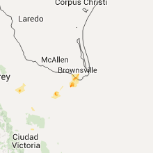


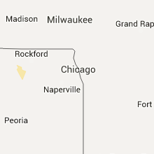


Cities Most Affected by Hail Storms of 5/30/2016
| Hail Size | Demographics of Zip Codes Affected | ||||||
|---|---|---|---|---|---|---|---|
| City | Count | Average | Largest | Pop Density | House Value | Income | Age |
| Hereford, TX | 2 | 2.38 | 2.75 | 15 | $46k | $29.6k | 30.9 |
| Snyder, TX | 2 | 1.88 | 2.00 | 15 | $43k | $31.7k | 36.2 |
| Crookston, MN | 1 | 2.50 | 2.50 | 28 | $65k | $37.0k | 37.0 |
| Selby, SD | 1 | 2.00 | 2.00 | 1 | $33k | $31.5k | 51.7 |
| Bison, SD | 1 | 2.00 | 2.00 | 0 | $35k | $28.6k | 46.8 |
| Meadow, SD | 1 | 1.75 | 1.75 | 0 | $31k | $19.7k | 43.8 |
| Faith, SD | 1 | 1.75 | 1.75 | 0 | $41k | $23.9k | 39.4 |
| Quinn, SD | 1 | 1.75 | 1.75 | 1 | $33k | $30.6k | 44.5 |
Hail and Wind Damage Spotted on 5/30/2016
Filter by Report Type:Hail ReportsWind Reports
States Impacted
Missouri, Kansas, South Dakota, North Dakota, South Carolina, Georgia, Iowa, Colorado, Mississippi, Nebraska, Minnesota, Montana, New York, Arkansas, Texas, Massachusetts, OklahomaMissouri
| Local Time | Report Details |
|---|---|
| 12:50 PM CDT | Multiple trees and powerlines dow in jasper county MO, 56.2 miles W of Springfield, MO |
| 6:48 PM CDT | Quarter sized hail reported near Watson, MO, 56.4 miles SSE of Omaha, NE, relayed through atchison county 911 center |
Kansas
| Local Time | Report Details |
|---|---|
| 1:45 PM CDT | 40x80 barn destroyed...power poles down...and 8 to 10 inch tree limbs down. possible microburst. time estimated...report came into dispatch at 1400 local tim in johnson county KS, 30.7 miles SW of Kansas City, MO |
| 7:59 PM CDT | Reported at atwood airpor in rawlins county KS, 32.6 miles N of Colby, KS |
| 8:03 PM CDT | Lasted 3 or 4 minute in thomas county KS, 18.1 miles W of Colby, KS |
| 10:00 PM CDT | Storm damage reported in graham county KS, 44.3 miles NW of Hays, KS |
| 10:40 PM CDT | Quarter sized hail reported near Kendall, KS, 36.4 miles W of Garden City, KS, hail covering the ground |
South Dakota
| Local Time | Report Details |
|---|---|
| 1:45 PM MDT | Hen Egg sized hail reported near Bison, SD, 95.7 miles NNE of Rapid City, SD |
| 3:12 PM CDT | Quarter sized hail reported near Selby, SD, 76.7 miles W of Aberdeen, SD |
| 2:20 PM MDT | Golf Ball sized hail reported near Faith, SD, 71.5 miles NNE of Rapid City, SD |
| 2:22 PM MDT | Quarter sized hail reported near Wall, SD, 46 miles E of Rapid City, SD, ground covered in hail |
| 2:22 PM MDT | Ground covered in hail in pennington county SD, 46 miles E of Rapid City, SD |
| 2:44 PM MDT | Golf Ball sized hail reported near Meadow, SD, 110 miles NNE of Rapid City, SD |
| 2:45 PM MDT | Golf Ball sized hail reported near Quinn, SD, 58.4 miles E of Rapid City, SD |
| 2:50 PM MDT | Quarter sized hail reported near Meadow, SD, 111.1 miles SW of Bismarck, ND |
| 3:03 PM MDT | Quarter sized hail reported near Philip, SD, 67.3 miles E of Rapid City, SD |
| 3:10 PM MDT | Quarter sized hail reported near Faith, SD, 87.2 miles NE of Rapid City, SD, 1.10 inch rainfall |
| 4:27 PM CDT | Quarter sized hail reported near Eureka, SD, 59.3 miles WNW of Aberdeen, SD |
| 6:50 PM CDT | 60 mph winds with pea hail. large cottonwood blown dow in walworth county SD, 67.3 miles N of Pierre, SD |
| 6:50 PM CDT | Hen Egg sized hail reported near Selby, SD, 72.2 miles NNE of Pierre, SD |
| 6:53 PM CDT | Quarter sized hail reported near Selby, SD, 75 miles W of Aberdeen, SD |
| 7:47 PM CDT | Storm damage reported in edmunds county SD, 41.1 miles W of Aberdeen, SD |
| 9:15 PM CDT | Quarter sized hail reported near Redfield, SD, 46.8 miles S of Aberdeen, SD |
| 9:22 PM CDT | Quarter sized hail reported near Redfield, SD, 46.8 miles S of Aberdeen, SD |
North Dakota
| Local Time | Report Details |
|---|---|
| 2:50 PM CDT | Quarter sized hail reported near Larimore, ND, 58.6 miles ESE of Devils Lake, ND |
| 3:20 PM CDT | Quarter sized hail reported near Larimore, ND, 58.6 miles ESE of Devils Lake, ND |
| 4:20 PM CDT | Quarter sized hail reported near Emerado, ND, 71.6 miles E of Devils Lake, ND, one mile stretch of hail covering highway 2 making it slippery. one car in the ditch. |
South Carolina
| Local Time | Report Details |
|---|---|
| 4:27 PM EDT | Quarter sized hail reported near Walhalla, SC, 26.3 miles W of Greenville, SC, hail observed near sertoma field. strong winds were observed at the time of the hail. |
| 4:28 PM EDT | A few trees down by storm winds to the southeast of walhalla and one tree reported down near senec in oconee county SC, 24.7 miles WSW of Greenville, SC |
Georgia
| Local Time | Report Details |
|---|---|
| 4:35 PM EDT | Emergency manager called the office to report multiple trees down on roadways within the city of dalto in whitfield county GA, 25.7 miles SE of Chattanooga, TN |
Iowa
| Local Time | Report Details |
|---|---|
| 4:08 PM CDT | Quarter sized hail reported near Minburn, IA, 23.9 miles WNW of Des Moines, IA, trained spotter reported hail up to quarter sized mixed in with smaller hail. |
| 4:46 PM CDT | Quarter sized hail reported near Boone, IA, 34.6 miles NNW of Des Moines, IA |
| 5:20 PM CDT | Quarter sized hail reported near Williams, IA, 53.1 miles SSW of Mason City, IA, trained spotter reports hail up to quarter size blanketed the ground... some damage to leaves and vegetation. delayed report. time estimated from radar. |
| 5:55 PM CDT | Quarter sized hail reported near Perry, IA, 28.9 miles WNW of Des Moines, IA, emergency management reports quarter sized hail. in addition very strong winds also reported. |
| 5:55 PM CDT | Powerlines down near the 19000 area of h ave west of minburn. time estimated from rada in dallas county IA, 30 miles WNW of Des Moines, IA |
| 6:26 PM CDT | 2 inch limbs and some power lines down in clarind in page county IA, 59.2 miles SE of Omaha, NE |
| 7:10 PM CDT | Quarter sized hail reported near Mason City, IA, 0.2 miles NNE of Mason City, IA |
| 7:30 PM CDT | Awos measured 57 knots. isolated downburst...no damage reported in buchanan county IA, 35.6 miles NNW of Cedar Rapids, IA |
| 7:55 PM CDT | Reported at olz in fayette county IA, 51.7 miles NNW of Cedar Rapids, IA |
| 8:05 PM CDT | 51 knots from the wnw reported at olz in fayette county IA, 51.7 miles NNW of Cedar Rapids, IA |
Colorado
| Local Time | Report Details |
|---|---|
| 3:21 PM MDT | No damage reported in logan county CO, 51.3 miles N of Yuma, CO |
| 4:28 PM MDT | Lasted 15-30 second in yuma county CO, 2.9 miles NW of Yuma, CO |
| 4:36 PM MDT | Wind blew like a hurricane taking some leaves off the trees. winds briefly reach 60 mph then declined to estimated 45 mp in cheyenne county CO, 81.4 miles SSW of Yuma, CO |
| 5:37 PM MDT | Estimated time of report from rada in kit carson county CO, 71.3 miles S of Yuma, CO |
| 5:50 PM MDT | Quarter sized hail reported near Eads, CO, 101.1 miles E of Pueblo, CO |
| 5:55 PM MDT | Ping Pong Ball sized hail reported near Eads, CO, 100.6 miles E of Pueblo, CO |
| 6:20 PM MDT | Power outage lasted 15-25 minute in cheyenne county CO, 80.6 miles WSW of Colby, KS |
Mississippi
| Local Time | Report Details |
|---|---|
| 4:29 PM CDT | Several trees and tree limbs down across the town. one tree fell onto a hom in washington county MS, 67.5 miles ENE of Bastrop, LA |
Nebraska
| Local Time | Report Details |
|---|---|
| 4:30 PM CDT | Quarter sized hail reported near Omaha, NE, 13.7 miles WSW of Omaha, NE |
| 4:40 PM CDT | Quarter sized hail reported near Omaha, NE, 14.4 miles WSW of Omaha, NE |
| 5:09 PM MDT | Winds were estimated at around 60 mph...with pea size hai in grant county NE, 78 miles NW of North Platte, NE |
| 6:10 PM CDT | Quarter sized hail reported near Wood Lake, NE, 14.2 miles SE of Valentine, NE, nickel to quarter hail with gusty winds |
| 5:30 PM MDT | Winds were estimated to be sustained at between 45 to 50 mp in keith county NE, 31.2 miles W of North Platte, NE |
| 5:47 PM MDT | Storm damage reported in chase county NE, 62.6 miles SW of North Platte, NE |
| 6:48 PM CDT | Storm damage reported in lincoln county NE, 19.2 miles W of North Platte, NE |
| 6:49 PM CDT | Storm damage reported in lincoln county NE, 19.2 miles W of North Platte, NE |
| 7:05 PM CDT | Storm damage reported in lincoln county NE, 5.1 miles N of North Platte, NE |
| 7:06 PM CDT | Storm damage reported in lincoln county NE, 17 miles SSW of North Platte, NE |
| 7:08 PM CDT | Storm damage reported in lincoln county NE, 5.1 miles N of North Platte, NE |
| 7:15 PM CDT | Storm damage reported in lincoln county NE, 5.1 miles N of North Platte, NE |
| 7:17 PM CDT | Storm damage reported in logan county NE, 20.8 miles NNE of North Platte, NE |
| 7:37 PM CDT | Sustained winds of 40 to 50 mph...with gusts around 60 mph. winds preceeded the rai in lincoln county NE, 22 miles ESE of North Platte, NE |
| 7:50 PM CDT | Storm damage reported in lincoln county NE, 23.6 miles SE of North Platte, NE |
| 8:02 PM CDT | Storm damage reported in red willow county NE, 59.8 miles NNE of Colby, KS |
| 8:05 PM CDT | Wind gusts were estimated between 50 and 60 mph. given storm history...60 mph wind gusts seemed most logica in lincoln county NE, 29.5 miles SE of North Platte, NE |
| 8:25 PM CDT | Sustained 60 mph winds in furnas county NE, 67.8 miles SSE of North Platte, NE |
| 8:35 PM CDT | Winds gusted to at least 60 mph in frontier county NE, 55.3 miles SE of North Platte, NE |
| 11:13 PM CDT | Storm damage reported in clay county NE, 23.4 miles S of Grand Island, NE |
Minnesota
| Local Time | Report Details |
|---|---|
| 4:40 PM CDT | Quarter sized hail reported near Fisher, MN, 64.9 miles N of Fargo, ND, mainly 0.50 to 0.75 inch hail. |
| 5:41 PM CDT | Quarter sized hail reported near Crookston, MN, 62.3 miles N of Fargo, ND, dime size hail beginning to cover ground with some stones to quarter size. |
| 5:45 PM CDT | Tennis Ball sized hail reported near Crookston, MN, 62.3 miles N of Fargo, ND, photo via social media of two large hail stones...possibly formed from several smaller stones aloft. |
| 5:50 PM CDT | Quarter sized hail reported near Crookston, MN, 64.7 miles N of Fargo, ND, hailed multiple times with a lot of pea to dime sized hail. |
| 6:25 PM CDT | Quarter sized hail reported near Crookston, MN, 63 miles N of Fargo, ND, mostly pea to dime size. |
Montana
| Local Time | Report Details |
|---|---|
| 4:40 PM MDT | Storm damage reported in fallon county MT, 85.1 miles E of Miles City, MT |
New York
| Local Time | Report Details |
|---|---|
| 6:50 PM EDT | Multiple trees down and some trees down on jordan lan in rensselaer county NY, 24.8 miles SE of Schenectady, NY |
| 6:56 PM EDT | Trees and wires down. time estimated by rada in rensselaer county NY, 26.8 miles SE of Schenectady, NY |
Arkansas
| Local Time | Report Details |
|---|---|
| 5:50 PM CDT | Quarter sized hail reported near Benton, AR, 23.9 miles SW of Little Rock, AR, thunderstorm produced hail from pea up to quarter size hail. |
Texas
| Local Time | Report Details |
|---|---|
| 6:18 PM CDT | Ping Pong Ball sized hail reported near Big Spring, TX, 59.3 miles ENE of Odessa, TX, nickel to ping pong hail. |
| 6:55 PM CDT | Ping Pong Ball sized hail reported near Big Spring, TX, 54.4 miles ENE of Odessa, TX |
| 6:55 PM CDT | Ping Pong Ball sized hail reported near Snyder, TX, 71.6 miles WNW of Abilene, TX, half dollar to ping pong hail fm 1607 |
| 7:27 PM CDT | Ping Pong Ball sized hail reported near Snyder, TX, 71.6 miles WNW of Abilene, TX, quarter to ping pong hail. |
| 7:34 PM CDT | Golf Ball sized hail reported near Snyder, TX, 71.1 miles WNW of Abilene, TX |
| 7:35 PM CDT | Hen Egg sized hail reported near Snyder, TX, 75.4 miles WNW of Abilene, TX, may be up to 2 1/2 inch hail. |
| 8:15 PM CDT | Hen Egg sized hail reported near Hereford, TX, 47 miles SW of Amarillo, TX, twitter photo forwarded by kvii-tv. |
| 8:27 PM CDT | Baseball sized hail reported near Hereford, TX, 44.7 miles SW of Amarillo, TX, photo forwarded from nws amarillo. time estimated from radar. |
| 8:47 PM CDT | Quarter sized hail reported near Tahoka, TX, 30 miles S of Lubbock, TX |
| 9:03 PM CDT | Half Dollar sized hail reported near Tahoka, TX, 30 miles S of Lubbock, TX, reported on the north side of town via spotter |
| 9:29 PM CDT | Quarter sized hail reported near Lubbock, TX, 8.3 miles SW of Lubbock, TX, reported by nws employee |
| 9:35 PM CDT | Storm damage reported in midland county TX, 30.6 miles ENE of Odessa, TX |
| 9:45 PM CDT | Quarter sized hail reported near Lubbock, TX, 1.6 miles WSW of Lubbock, TX |
| 9:45 PM CDT | Quarter sized hail reported near Lubbock, TX, 4.5 miles SSW of Lubbock, TX |
| 9:49 PM CDT | Quarter sized hail reported near Lubbock, TX, 2.6 miles SSW of Lubbock, TX, via nws employee |
| 9:50 PM CDT | Half Dollar sized hail reported near Lubbock, TX, 6.5 miles SSW of Lubbock, TX |
| 10:25 PM CDT | Half Dollar sized hail reported near Channing, TX, 46.7 miles NW of Amarillo, TX |
| 10:55 PM CDT | At midkiff and loop 250... direction nw in midland county TX, 20.2 miles ENE of Odessa, TX |
| 11:44 PM CDT | Quarter sized hail reported near Stanton, TX, 38.4 miles NE of Odessa, TX |
| 12:43 AM CDT | Quarter sized hail reported near Bushland, TX, 17.1 miles WNW of Amarillo, TX, quarter size hail reported on fm1061 west of the helium plant on the nw side of amarillo. |
Massachusetts
| Local Time | Report Details |
|---|---|
| 7:35 PM EDT | Trees down on elm street and dorchester avenue. time estimated by rada in berkshire county MA, 44.4 miles SE of Schenectady, NY |
| 7:35 PM EDT | Large tree down on wires at west street and westbrook terrance. time estimated by rada in berkshire county MA, 40.3 miles SE of Schenectady, NY |
| 7:53 PM EDT | Tree and wires down on route 41 near quarry roa in berkshire county MA, 44.8 miles SE of Schenectady, NY |
Oklahoma
| Local Time | Report Details |
|---|---|
| 4:15 AM CDT | Storm damage reported in woodward county OK, 25.3 miles NE of Woodward, OK |
Connect with Interactive Hail Maps