

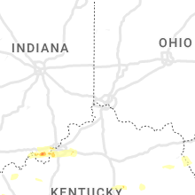
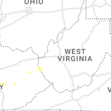
Hail Map for Monday, May 8, 2023

Number of Impacted Households on 5/8/2023
0
Impacted by 1" or Larger Hail
0
Impacted by 1.75" or Larger Hail
0
Impacted by 2.5" or Larger Hail
Square Miles of Populated Area Impacted on 5/8/2023
0
Impacted by 1" or Larger Hail
0
Impacted by 1.75" or Larger Hail
0
Impacted by 2.5" or Larger Hail


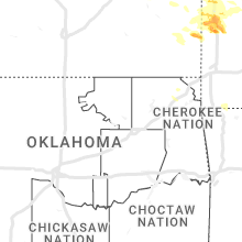


Cities Most Affected by Hail Storms of 5/8/2023
| Hail Size | Demographics of Zip Codes Affected | ||||||
|---|---|---|---|---|---|---|---|
| City | Count | Average | Largest | Pop Density | House Value | Income | Age |
| Salem, MO | 4 | 2.44 | 2.75 | 21 | $63k | $27.0k | 42.8 |
| Boss, MO | 2 | 2.13 | 2.50 | 5 | $43k | $27.5k | 44.7 |
| Bunker, MO | 1 | 2.50 | 2.50 | 4 | $45k | $21.9k | 43.8 |
| Bourbon, MO | 1 | 2.50 | 2.50 | 22 | $68k | $36.2k | 39.6 |
| Sunrise Beach, MO | 1 | 2.00 | 2.00 | 167 | $127k | $33.6k | 57.3 |
| Bixby, MO | 1 | 2.00 | 2.00 | 6 | $48k | $23.1k | 40.6 |
| Saint James, MO | 1 | 2.00 | 2.00 | 48 | $70k | $27.9k | 40.4 |
| Hawkins, TX | 1 | 2.00 | 2.00 | 67 | $50k | $34.0k | 51.5 |
| Lampasas, TX | 1 | 1.75 | 1.75 | 21 | $63k | $34.1k | 41.2 |
| Gladewater, TX | 1 | 1.75 | 1.75 | 173 | $65k | $33.0k | 37.9 |
| Corydon, IN | 1 | 1.75 | 1.75 | 101 | $99k | $42.4k | 39.7 |
| Richards, MO | 1 | 1.75 | 1.75 | 6 | $24k | $36.1k | 35.8 |
| Louisville, KY | 1 | 1.75 | 1.75 | 3016 | $86k | $35.1k | 39.5 |
| Mineola, TX | 1 | 1.75 | 1.75 | 71 | $71k | $31.9k | 44.6 |
| Roach, MO | 1 | 1.75 | 1.75 | 48 | $137k | $37.1k | 51.3 |
Hail and Wind Damage Spotted on 5/8/2023
Filter by Report Type:Hail ReportsWind Reports
States Impacted
Kentucky, Tennessee, Texas, Missouri, Louisiana, Utah, South Dakota, Wisconsin, Kansas, Iowa, Arkansas, Minnesota, Illinois, IndianaKentucky
| Local Time | Report Details |
|---|---|
| 11:32 AM CDT | Several trees down throughout the city and count in mccracken county KY, 51.4 miles ESE of Cape Girardeau, MO |
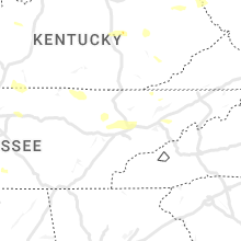
| 8:04 PM CDT | Half Dollar sized hail reported near Dixon, KY, 32.3 miles SSW of Evansville, IN, half dollar and quarter sized hail in dixon. |
| 8:35 PM CDT | Half Dollar sized hail reported near Hanson, KY, 38.7 miles S of Evansville, IN |
| 9:39 PM CDT | Quarter sized hail reported near Graham, KY, 52.5 miles SSE of Evansville, IN, quarter sized hail in graham. |
| 10:06 PM CDT | Several trees down around the count in muhlenberg county KY, 57.6 miles SSE of Evansville, IN |
| 11:05 PM CDT | Roof/side of building damaged/removed from wind. trees also down in the are in ballard county KY, 32.4 miles ESE of Cape Girardeau, MO |
| 11:09 PM CDT | Corrects previous tstm wnd dmg report from 1 wsw la center. trees and powerlines down across the count in ballard county KY, 34.5 miles ESE of Cape Girardeau, MO |
| 11:15 PM CDT | Quarter sized hail reported near Lewisburg, KY, 56.2 miles N of Nashville, TN, public social media picture relayed by broadcast media. |
| 11:36 PM CDT | Trees down in mayfiel in graves county KY, 42.3 miles N of Mc Kenzie, TN |
| 11:50 PM CDT | Trees and powerlines down across the count in ballard county KY, 34.5 miles ESE of Cape Girardeau, MO |
| 2:20 AM EDT | Quarter sized hail reported near Mc Kee, KY, 15.8 miles SSW of Irvine, KY, media image shared of estimated quarter sized hail. time estimated from radar. |
| 3:39 AM EDT | Golf Ball sized hail reported near Louisville, KY, 14.2 miles NNW of Louisville, KY |
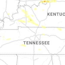
Tennessee
| Local Time | Report Details |
|---|---|
| 11:58 AM CDT | Quarter sized hail reported near Newbern, TN, 42.6 miles W of Mc Kenzie, TN, quarter sized hail. |
| 12:01 AM CDT | Quarter sized hail reported near Dyersburg, TN, 48.6 miles W of Mc Kenzie, TN, quarter sized hail. |
| 2:20 AM CDT | Delayed report for an individual that had about 30 trees down along fence damag in wilson county TN, 23.4 miles E of Nashville, TN |
| 6:02 AM EDT | Tree down on power line in knox county TN, 4.1 miles NE of Knoxville, TN |
| 6:04 AM EDT | Tree down in roa in knox county TN, 0.6 miles E of Knoxville, TN |
| 6:10 AM EDT | Tree down blocking roa in knox county TN, 12.2 miles ENE of Knoxville, TN |
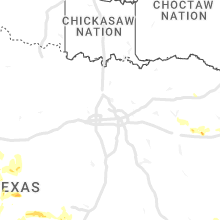
Texas
| Local Time | Report Details |
|---|---|
| 3:10 PM CDT | Hardin 911 reports possible tornado touched down on fm 421 between sour lake and lumberton. numerous trees were downed onto the roadway and power lines. time estimated in hardin county TX, 34.3 miles WNW of Beaumont, TX |
| 3:15 PM CDT | Quarter sized hail reported near Lumberton, TX, 33 miles WNW of Beaumont, TX, media reports 1 inch hail west of lumberton. |
| 3:25 PM CDT | Numerous power outages reported in and around lumberton. time estimated by rada in hardin county TX, 33 miles WNW of Beaumont, TX |
| 3:42 PM CDT | Softwood tree split in hal in jefferson county TX, 26.7 miles W of Beaumont, TX |
| 3:43 PM CDT | Quarter sized hail reported near La Grange, TX, 91.3 miles W of Houston, TX, nickel to quarter size hail in la grange. |
| 4:19 PM CDT | Mesonet reports thunderstorm wind gust of 59 mp in orange county TX, 8 miles W of Beaumont, TX |
| 4:30 PM CDT | Tin roof blown off of a hair salo in orange county TX, 2.1 miles WNW of Beaumont, TX |
| 4:34 PM CDT | A trampoline was blown trough a fence off of snake roa in orange county TX, 2.3 miles WNW of Beaumont, TX |
| 4:36 PM CDT | Large branch broken off a tre in jefferson county TX, 24.2 miles W of Beaumont, TX |
| 4:36 PM CDT | Large tree fell on house... damaging a roo in orange county TX, 2.3 miles WNW of Beaumont, TX |
| 4:36 PM CDT | Part of a tin roof was blown across 9th street in orange... tx. taking down a power lin in orange county TX, 0.3 miles SW of Beaumont, TX |
| 4:37 PM CDT | Large portion of orange texas without power after storm has passe in orange county TX, 0.6 miles NE of Beaumont, TX |
| 5:35 PM CDT | Quarter sized hail reported near Muldoon, TX, 90.9 miles ENE of San Antonio, TX, quarter size hail currently falling. |
| 5:56 PM CDT | Half Dollar sized hail reported near Tomball, TX, 26.9 miles NNW of Houston, TX, public and media reports of hail between quarter and half dollar size. |
| 6:23 PM CDT | *** 1 fatal *** law enforcement reported that a tree fell on a vehicle near the intersection of east cypresswood dr and whitewood dr. one fatality reporte in harris county TX, 20.2 miles N of Houston, TX |
| 6:40 PM CDT | Wind gust occurred at the kiah asos sit in harris county TX, 15.1 miles N of Houston, TX |
| 7:15 PM CDT | Golf Ball sized hail reported near Gladewater, TX, 73.7 miles W of Shreveport, LA, a picture was posted to social media of golf ball size hail that fell in the friendship community southwest of gladewater. |
| 7:21 PM CDT | Golf Ball sized hail reported near Lampasas, TX, 21.6 miles SW of Killeen, TX, a lot of small hail... but biggest hail was up to golf ball size. |
| 7:35 PM CDT | Hen Egg sized hail reported near Hawkins, TX, 85.5 miles W of Shreveport, LA, mostly quarter size hail with some much larger hailstones in excess of golfballs are covering the ground in hawkins. |
| 8:06 PM CDT | Half Dollar sized hail reported near Burnet, TX, 28.9 miles SW of Killeen, TX, hail currently falling... most is pea size... but the biggest is a little bigger than quarter size. |
| 8:19 PM CDT | Quarter sized hail reported near Ballinger, TX, 50.5 miles SSW of Abilene, TX |
| 8:20 PM CDT | Golf Ball sized hail reported near Mineola, TX, 80.9 miles E of Dallas, TX, golfball size hail fell near the hainesville community. |
| 8:23 PM CDT | Quarter sized hail reported near Coleman, TX, 46.4 miles SSE of Abilene, TX |
| 9:30 PM CDT | Trained spotters reported winds of 60 to 65 mph in the city of bang in brown county TX, 62.3 miles SE of Abilene, TX |
| 1:19 AM CDT | The asos station at brownsville-south padre international airport gusted to 64 mph at 1:19am cd in cameron county TX, 4.1 miles E of Brownsville, TX |
| 1:41 AM CDT | Port isabel police department reported several powerlines down around town. timing based on rada in cameron county TX, 21.3 miles ENE of Brownsville, TX |
| 1:41 AM CDT | The port isabel police department shared pictures on social media showing damage to the sunoco gas station awning at the corner of hwy48 and hwy100 and an ice chest tha in cameron county TX, 20.3 miles NE of Brownsville, TX |
| 1:45 AM CDT | Member of the public from isla blanca reported power being out... two trailers flipped onto their ceilings... awnings ripped off... trailer jacks bent... road signs ben in cameron county TX, 23.9 miles ENE of Brownsville, TX |
| 1:45 AM CDT | South padre police department reports multiple powerlines down across the island. timing based on rada in cameron county TX, 24.6 miles ENE of Brownsville, TX |
| 1:54 AM CDT | Corrects previous marine tstm wind report from 1 sse port isabel. the noaa national ocean service station at port isabel recorded a wind gust of 52 knots... or 60 mph in cameron county TX, 20.4 miles ENE of Brownsville, TX |
Missouri
| Local Time | Report Details |
|---|---|
| 3:56 PM CDT | Quarter sized hail reported near Rolla, MO, 17.2 miles NNW of Salem, MO, quarter to nickel size hail. on mo 72. |
| 4:20 PM CDT | Hen Egg sized hail reported near Saint James, MO, 14.3 miles NNW of Salem, MO, trained spotter measured hail ranging from 1.75 inches mostly... to a few 2 inches stones. |
| 4:45 PM CDT | Hen Egg sized hail reported near Salem, MO, 7.6 miles NNE of Salem, MO, chaser looked like golf balls possibly bigger... but no bigger than 2 inches. |
| 5:02 PM CDT | Quarter sized hail reported near Deepwater, MO, 72.8 miles NNW of Springfield, MO, some hail approaching half dollar size. |
| 5:11 PM CDT | Quarter sized hail reported near Salem, MO, 4.4 miles N of Salem, MO, report from mping: quarter (1.00 in.). |
| 5:12 PM CDT | Quarter sized hail reported near Appleton City, MO, 69.7 miles SSE of Kansas City, MO, via social media picture. |
| 5:30 PM CDT | Ping Pong Ball sized hail reported near Foster, MO, 61.5 miles ENE of Chanute, KS, relayed via social media. |
| 5:31 PM CDT | Tennis Ball sized hail reported near Salem, MO, 6.9 miles E of Salem, MO, corrects the time of previous hail report from 5 wnw stone hill. confirmed this round of golf ball to tennis ball size hail fell around 530pm per social media. |
| 5:40 PM CDT | Quarter sized hail reported near Climax Springs, MO, 64 miles SW of Columbia, MO, delayed report. coffman bend area of climax springs had a bunch of quarter sized hail. time estimated via radar. |
| 5:46 PM CDT | Half Dollar sized hail reported near Rolla, MO, 19.4 miles NNW of Salem, MO |
| 5:58 PM CDT | Tennis Ball sized hail reported near Bunker, MO, 16.5 miles ESE of Salem, MO, lime to tennis ball sized hail in marcoot missouri. |
| 6:12 PM CDT | Ping Pong Ball sized hail reported near Camdenton, MO, 59.8 miles NNE of Springfield, MO, via social media. |
| 6:14 PM CDT | Golf Ball sized hail reported near Boss, MO, 19 miles E of Salem, MO, delayed report of hail slightly larger than golf balls in boss. |
| 6:15 PM CDT | Golf Ball sized hail reported near Roach, MO, 62.6 miles SSW of Columbia, MO, via social media pic. |
| 6:17 PM CDT | Half Dollar sized hail reported near Rich Hill, MO, 66.3 miles ENE of Chanute, KS, relayed via social media. |
| 6:20 PM CDT | Quarter sized hail reported near Camdenton, MO, 64.4 miles SSW of Columbia, MO, via social media pic. |
| 6:24 PM CDT | Hen Egg sized hail reported near Sunrise Beach, MO, 58.5 miles SSW of Columbia, MO, via social media picture. |
| 6:25 PM CDT | Half Dollar sized hail reported near Richland, MO, 51.5 miles WNW of Salem, MO, delayed report of hail at least half dollar size hail west of crocker. |
| 6:25 PM CDT | Ping Pong Ball sized hail reported near Camdenton, MO, 63.3 miles NNE of Springfield, MO, quarter to ping pong size. |
| 6:25 PM CDT | Quarter sized hail reported near Linn Creek, MO, 64.7 miles NNE of Springfield, MO, social media picture. |
| 6:30 PM CDT | Ping Pong Ball sized hail reported near Sunrise Beach, MO, 58.5 miles SSW of Columbia, MO, via social media pic. |
| 6:35 PM CDT | Hen Egg sized hail reported near Bixby, MO, 22.3 miles E of Salem, MO, radar estimated time. occurred in buick... mo. |
| 6:36 PM CDT | Ping Pong Ball sized hail reported near Crocker, MO, 45.6 miles WNW of Salem, MO |
| 6:47 PM CDT | Quarter sized hail reported near Montreal, MO, 62.6 miles WNW of Salem, MO, report from mping: quarter (1.00 in.). |
| 6:48 PM CDT | Ping Pong Ball sized hail reported near Osage Beach, MO, 60.6 miles SSW of Columbia, MO, via social media pic. |
| 6:55 PM CDT | Ping Pong Ball sized hail reported near Saint Robert, MO, 37.7 miles WNW of Salem, MO |
| 6:55 PM CDT | Quarter sized hail reported near Boss, MO, 25.9 miles ESE of Salem, MO, corrects previous hail report from 3 sw oates. radar estimated time. video of falling hail provided via twitter. |
| 6:55 PM CDT | Quarter sized hail reported near Rolla, MO, 19 miles NW of Salem, MO |
| 6:55 PM CDT | Quarter sized hail reported near Schell City, MO, 70.2 miles ENE of Chanute, KS, delayed report 7 miles west of schell city of a few rounds of dime to quarter size hail. |
| 6:59 PM CDT | Quarter sized hail reported near Rolla, MO, 13.2 miles NW of Salem, MO |
| 7:00 PM CDT | Quarter sized hail reported near Rolla, MO, 14.6 miles NW of Salem, MO, nickel to quarter size hail. |
| 7:00 PM CDT | Quarter sized hail reported near Boss, MO, 25.9 miles ESE of Salem, MO, radar estimated time. video of falling hail provided via twitter. |
| 7:02 PM CDT | Quarter sized hail reported near Boss, MO, 26.8 miles ESE of Salem, MO, report from mping: quarter (1.00 in.). |
| 7:04 PM CDT | Quarter sized hail reported near Waynesville, MO, 39.9 miles WNW of Salem, MO, dime to quarter size hail. still hailing. |
| 7:05 PM CDT | Quarter sized hail reported near Schell City, MO, 70.2 miles ENE of Chanute, KS, delayed report 7 miles west of schell city of a few rounds of dime to quarter size hail. large hail fell for about 20 minutes straight. |
| 7:15 PM CDT | Quarter sized hail reported near Waynesville, MO, 41.4 miles WNW of Salem, MO, report from mping: quarter (1.00 in.). |
| 7:24 PM CDT | Half Dollar sized hail reported near Waynesville, MO, 41.4 miles WNW of Salem, MO, via social media picture. |
| 7:25 PM CDT | Golf Ball sized hail reported near Richards, MO, 58.6 miles ENE of Chanute, KS |
| 7:30 PM CDT | Quarter sized hail reported near Bixby, MO, 23.4 miles E of Salem, MO, reported via weather net. reported from bixby country store. |
| 7:30 PM CDT | Half Dollar sized hail reported near Waynesville, MO, 42.1 miles WNW of Salem, MO, via email to contact. |
| 7:33 PM CDT | Quarter sized hail reported near Nevada, MO, 61.6 miles ENE of Chanute, KS, report from mping: quarter (1.00 in.). |
| 7:34 PM CDT | Quarter sized hail reported near Nevada, MO, 61.6 miles ENE of Chanute, KS, report from mping: quarter (1.00 in.). |
| 7:36 PM CDT | Quarter sized hail reported near Annapolis, MO, 49.2 miles ESE of Salem, MO, quarter sized hail covering the ground. |
| 7:36 PM CDT | Quarter sized hail reported near Annapolis, MO, 49.7 miles ESE of Salem, MO, report from mping: quarter (1.00 in.). |
| 7:41 PM CDT | Baseball sized hail reported near Salem, MO, 6.9 miles E of Salem, MO, via social media pic. |
| 7:41 PM CDT | Tennis Ball sized hail reported near Salem, MO, 6.9 miles E of Salem, MO, corrects size of previous hail report from 5 wnw stone hill. via social media pic. |
| 7:44 PM CDT | Tennis Ball sized hail reported near Bourbon, MO, 40.4 miles NNE of Salem, MO, public report submitted via social media. report was accompanied by a photo. time estimated by radar. |
| 7:45 PM CDT | Half Dollar sized hail reported near Nevada, MO, 61.3 miles E of Chanute, KS |
| 8:00 PM CDT | Tennis Ball sized hail reported near Boss, MO, 18.7 miles E of Salem, MO, via broadcast media with a picture. |
| 8:15 PM CDT | Quarter sized hail reported near Deerfield, MO, 51.6 miles ENE of Chanute, KS, delayed report of quarter size hail between nevada and fort scott kansas. time estimated via radar. |
| 8:48 PM CDT | Ping Pong Ball sized hail reported near Nevada, MO, 62.7 miles E of Chanute, KS, via phone call. between mm 91.5 and 81.5. winds estimated 60 mph. |
| 8:49 PM CDT | Relayed report of large trees down over highway 21. time estimated by rada in reynolds county MO, 44.1 miles SE of Salem, MO |
| 9:01 PM CDT | Quarter sized hail reported near Moundville, MO, 55.1 miles E of Chanute, KS, delayed report of quarter size hail in the moundville area. |
| 9:10 PM CDT | Quarter sized hail reported near Greenville, MO, 41.7 miles W of Cape Girardeau, MO, quarter sized hail covering the ground in cascade. |
| 9:25 PM CDT | Quarter sized hail reported near Glenallen, MO, 32.5 miles W of Cape Girardeau, MO, reported at arrowhead campground. |
| 9:35 PM CDT | Quarter sized hail reported near Willow Springs, MO, 50.6 miles SSW of Salem, MO, via social media. |
| 9:45 PM CDT | S.o. reports trees down countywid in wayne county MO, 51.3 miles WSW of Cape Girardeau, MO |
| 9:46 PM CDT | Large tree uprooted and partially snappe in butler county MO, 59.9 miles SW of Cape Girardeau, MO |
| 9:49 PM CDT | Several trees down and reports of at least quarter sized hai in bollinger county MO, 24.7 miles WSW of Cape Girardeau, MO |
| 10:05 PM CDT | Tree fell across road in bloomfiel in stoddard county MO, 35.5 miles SW of Cape Girardeau, MO |
| 10:28 PM CDT | Tree fell on hous in scott county MO, 29.2 miles S of Cape Girardeau, MO |
| 10:30 PM CDT | Nearly 100 power outages in the peace valley area. time estimated via rada in howell county MO, 54 miles SSW of Salem, MO |
| 10:45 PM CDT | Cgi asos reported a 62 kt wind gus in scott county MO, 4.3 miles S of Cape Girardeau, MO |
| 10:45 PM CDT | Storm damage reported in mississippi county MO, 37 miles SSE of Cape Girardeau, MO |
| 11:11 PM CDT | Numerous trees down i-55 sb at the 86 mile marke in scott county MO, 18.1 miles S of Cape Girardeau, MO |
Louisiana
| Local Time | Report Details |
|---|---|
| 5:15 PM CDT | Trees down in blanchard... including across highway 173 between smith and bostwick roads... as well as blanchard furrh road about 1/2 mile west of the railroad crossing in caddo county LA, 8.1 miles WNW of Shreveport, LA |
Utah
| Local Time | Report Details |
|---|---|
| 5:15 PM MDT | Storm damage reported in tooele county UT, 50.6 miles SSW of Salt Lake City, UT |
| 5:40 PM MDT | Crow mountain - 5629 f in cache county UT, 76.7 miles N of Salt Lake City, UT |
South Dakota
| Local Time | Report Details |
|---|---|
| 6:16 PM CDT | Quarter sized hail reported near Elk Point, SD, 60.5 miles S of Sioux Falls, SD |
Wisconsin
| Local Time | Report Details |
|---|---|
| 6:22 PM CDT | Quarter sized hail reported near Beldenville, WI, 47.7 miles ESE of Minneapolis, MN |
| 6:40 PM CDT | Half Dollar sized hail reported near Maiden Rock, WI, 51.7 miles ESE of Minneapolis, MN |
| 6:54 PM CDT | Quarter sized hail reported near Maiden Rock, WI, 53.5 miles ESE of Minneapolis, MN, lots of hail up to the size of quarters... lasted for about 5 minutes. |
Kansas
| Local Time | Report Details |
|---|---|
| 6:31 PM CDT | Half Dollar sized hail reported near Prescott, KS, 49.1 miles ENE of Chanute, KS, photo via twitter. |
Iowa
| Local Time | Report Details |
|---|---|
| 6:35 PM CDT | Ping Pong Ball sized hail reported near Terril, IA, 44.8 miles NNE of Storm Lake, IA |
| 7:10 PM CDT | Quarter sized hail reported near Graettinger, IA, 43.9 miles NNE of Storm Lake, IA |
| 7:29 PM CDT | Quarter sized hail reported near Mapleton, IA, 44.6 miles SW of Storm Lake, IA, monona county dispatch relayed report from officer in mapleton of pea to quarter sized hail. |
| 8:09 PM CDT | Quarter sized hail reported near West Bend, IA, 43.4 miles ENE of Storm Lake, IA |
| 10:10 PM CDT | Quarter sized hail reported near Fort Dodge, IA, 52 miles E of Storm Lake, IA |
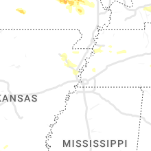
Arkansas
| Local Time | Report Details |
|---|---|
| 6:49 PM CDT | Quarter sized hail reported near El Dorado, AR, 54.2 miles NW of Bastrop, LA, quarter size hail fell near the fairgrounds... as well as on highway 167 on the north side of el dorado. |
| 7:10 PM CDT | A tree was downed on wesson road in the wesson communit in union county AR, 53.1 miles WNW of Bastrop, LA |
| 7:47 PM CDT | A tree was downed in horatio. hail was also reported... but a size was not know in sevier county AR, 29.5 miles W of Nashville, AR |
| 12:36 AM CDT | Quarter sized hail reported near Jonesboro, AR, 57.6 miles NW of Memphis, TN, quarter sized hail reported. |
Minnesota
| Local Time | Report Details |
|---|---|
| 6:54 PM CDT | Quarter sized hail reported near Jackson, MN, 63.1 miles NNE of Storm Lake, IA |
Illinois
| Local Time | Report Details |
|---|---|
| 10:00 PM CDT | Numerous trees and power lines down across alexander count in alexander county IL, 29 miles SE of Cape Girardeau, MO |
| 10:05 PM CDT | Several trees down between pulaski and mounds. also semi trailer blown ove in pulaski county IL, 23.2 miles SE of Cape Girardeau, MO |
Indiana
| Local Time | Report Details |
|---|---|
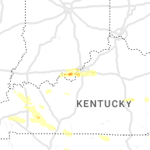
| 3:04 AM EDT | Quarter sized hail reported near Corydon, IN, 26.1 miles WNW of Louisville, KY |
| 3:07 AM EDT | Ping Pong Ball sized hail reported near Corydon, IN, 24.1 miles WNW of Louisville, KY |
| 3:07 AM EDT | Golf Ball sized hail reported near Corydon, IN, 24.2 miles WNW of Louisville, KY, public relayed by broadcast media. |
Connect with Interactive Hail Maps