

Hail Map for Sunday, May 7, 2023

Number of Impacted Households on 5/7/2023
0
Impacted by 1" or Larger Hail
0
Impacted by 1.75" or Larger Hail
0
Impacted by 2.5" or Larger Hail
Square Miles of Populated Area Impacted on 5/7/2023
0
Impacted by 1" or Larger Hail
0
Impacted by 1.75" or Larger Hail
0
Impacted by 2.5" or Larger Hail


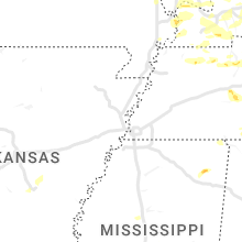


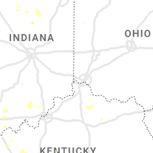


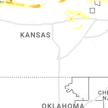


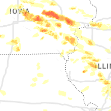

Cities Most Affected by Hail Storms of 5/7/2023
| Hail Size | Demographics of Zip Codes Affected | ||||||
|---|---|---|---|---|---|---|---|
| City | Count | Average | Largest | Pop Density | House Value | Income | Age |
| Chatham, IL | 6 | 2.17 | 3.25 | 361 | $111k | $60.4k | 36.1 |
| Newton, IA | 5 | 2.25 | 2.75 | 119 | $82k | $40.9k | 41.7 |
| Ames, IA | 4 | 2.19 | 2.50 | 496 | $134k | $37.5k | 28.5 |
| Grinnell, IA | 3 | 2.42 | 2.75 | 56 | $91k | $37.5k | 38.1 |
| Bridgewater, IA | 3 | 2.33 | 2.50 | 5 | $21k | $30.2k | 47.0 |
| Abilene, TX | 4 | 1.75 | 1.75 | 407 | $79k | $40.5k | 34.7 |
| Malvern, IA | 3 | 1.92 | 2.25 | 12 | $77k | $38.6k | 41.1 |
| Nokomis, IL | 2 | 2.75 | 2.75 | 31 | $48k | $32.5k | 42.3 |
| Miles, TX | 2 | 2.38 | 3.00 | 7 | $59k | $35.9k | 39.0 |
| Baxter, IA | 2 | 2.25 | 2.75 | 15 | $81k | $39.7k | 40.4 |
| Good Hope, IL | 2 | 2.25 | 2.50 | 11 | $65k | $43.0k | 45.9 |
| Kellogg, IA | 2 | 2.25 | 2.50 | 19 | $77k | $42.5k | 45.7 |
| Rose Hill, IA | 2 | 2.00 | 2.00 | 8 | $54k | $34.1k | 46.6 |
| Montezuma, IA | 2 | 1.88 | 2.00 | 17 | $85k | $40.2k | 46.9 |
| Merkel, TX | 2 | 1.88 | 2.00 | 15 | $42k | $32.0k | 40.5 |
| Dunbar, NE | 2 | 1.88 | 2.00 | 7 | $58k | $45.7k | 41.4 |
| Lake Village, IN | 2 | 1.75 | 1.75 | 36 | $101k | $41.9k | 41.8 |
| Collins, IA | 2 | 1.75 | 1.75 | 11 | $78k | $40.6k | 40.1 |
| Wever, IA | 2 | 1.75 | 1.75 | 20 | $84k | $51.5k | 47.7 |
| Rotan, TX | 1 | 3.00 | 3.00 | 5 | $31k | $24.2k | 45.7 |
| Marengo, IA | 1 | 2.75 | 2.75 | 32 | $78k | $40.9k | 43.1 |
| Clyde, TX | 1 | 2.50 | 2.50 | 27 | $57k | $34.1k | 40.7 |
| Raymond, NE | 1 | 2.50 | 2.50 | 24 | $115k | $58.3k | 43.1 |
| Lynnville, IA | 1 | 2.50 | 2.50 | 18 | $74k | $40.7k | 42.4 |
| Morrisonville, IL | 1 | 2.50 | 2.50 | 10 | $61k | $37.2k | 40.7 |
| Carroll, IA | 1 | 2.50 | 2.50 | 69 | $86k | $40.1k | 42.0 |
| Benton, KY | 1 | 2.25 | 2.25 | 101 | $83k | $36.0k | 43.9 |
| Auburn, IL | 1 | 2.00 | 2.00 | 111 | $85k | $45.4k | 35.7 |
| Goodland, KS | 1 | 2.00 | 2.00 | 9 | $65k | $33.1k | 41.5 |
| Marysville, KS | 1 | 2.00 | 2.00 | 20 | $60k | $33.8k | 44.0 |
| Divernon, IL | 1 | 2.00 | 2.00 | 31 | $84k | $46.9k | 42.5 |
| Mount Pleasant, IA | 1 | 2.00 | 2.00 | 54 | $85k | $38.4k | 39.1 |
| Dresden, KS | 1 | 2.00 | 2.00 | 2 | $29k | $24.9k | 49.9 |
| Benjamin, TX | 1 | 1.75 | 1.75 | 0 | $27k | $31.6k | 40.5 |
| Wyatt, MO | 1 | 1.75 | 1.75 | 0 | $31k | $18.3k | 40.9 |
| Raymond, IL | 1 | 1.75 | 1.75 | 14 | $67k | $38.5k | 42.9 |
| New Underwood, SD | 1 | 1.75 | 1.75 | 1 | $55k | $34.9k | 41.3 |
| Fruitland, IA | 1 | 1.75 | 1.75 | 462 | $114k | $58.0k | 36.9 |
| Fairfield, IA | 1 | 1.75 | 1.75 | 66 | $77k | $33.5k | 43.7 |
| Rapid City, SD | 1 | 1.75 | 1.75 | 583 | $75k | $30.9k | 32.9 |
| Waggoner, IL | 1 | 1.75 | 1.75 | 11 | $43k | $37.5k | 40.8 |
| Okawville, IL | 1 | 1.75 | 1.75 | 28 | $80k | $36.9k | 41.0 |
| Hubbard, IA | 1 | 1.75 | 1.75 | 7 | $64k | $35.5k | 46.0 |
| Mount Sterling, IL | 1 | 1.75 | 1.75 | 20 | $50k | $34.0k | 35.8 |
| Hillsboro, IL | 1 | 1.75 | 1.75 | 75 | $59k | $35.5k | 39.7 |
| Hamburg, IA | 1 | 1.75 | 1.75 | 13 | $0k | $31.5k | 44.1 |
| West Point, IA | 1 | 1.75 | 1.75 | 23 | $83k | $45.0k | 47.0 |
| Prairie City, IL | 1 | 1.75 | 1.75 | 17 | $26k | $38.1k | 42.2 |
| Scranton, IA | 1 | 1.75 | 1.75 | 8 | $45k | $30.2k | 47.0 |
| West Liberty, IA | 1 | 1.75 | 1.75 | 59 | $87k | $41.8k | 34.9 |
| O Fallon, IL | 1 | 1.75 | 1.75 | 1242 | $124k | $55.3k | 36.8 |
| Dyess AFB, TX | 1 | 1.75 | 1.75 | 618 | $38k | $33.8k | 21.3 |
| Freeburg, IL | 1 | 1.75 | 1.75 | 110 | $113k | $53.2k | 43.4 |
| Aladdin, WY | 1 | 1.75 | 1.75 | 1 | $189k | $15.0k | 55.4 |
| Herndon, KY | 1 | 1.75 | 1.75 | 13 | $91k | $41.6k | 38.4 |
| Luzerne, IA | 1 | 1.75 | 1.75 | 17 | $56k | $45.0k | 44.0 |
| Wingate, TX | 1 | 1.75 | 1.75 | 1 | $33k | $27.2k | 54.7 |
| Marietta, IL | 1 | 1.75 | 1.75 | 9 | $37k | $38.2k | 45.5 |
| Plattsmouth, NE | 1 | 1.75 | 1.75 | 131 | $107k | $45.9k | 40.3 |
| Alton, KS | 1 | 1.75 | 1.75 | 2 | $15k | $33.2k | 48.8 |
| Melbourne, IA | 1 | 1.75 | 1.75 | 16 | $73k | $48.9k | 37.4 |
| Wall, SD | 1 | 1.75 | 1.75 | 1 | $63k | $36.2k | 43.8 |
| Imogene, IA | 1 | 1.75 | 1.75 | 7 | $42k | $35.2k | 48.0 |
| Tuscola, TX | 1 | 1.75 | 1.75 | 31 | $76k | $46.7k | 41.0 |
| Morris, IL | 1 | 1.75 | 1.75 | 135 | $137k | $51.9k | 39.9 |
| New Burnside, IL | 1 | 1.75 | 1.75 | 26 | $31k | $30.3k | 40.7 |
Hail and Wind Damage Spotted on 5/7/2023
Filter by Report Type:Hail ReportsWind Reports
States Impacted
Indiana, Kentucky, Illinois, Nebraska, Iowa, Tennessee, Texas, North Carolina, Kansas, Missouri, Wyoming, Mississippi, South Dakota, South CarolinaIndiana
| Local Time | Report Details |
|---|---|
| 8:21 AM EDT | Hayesville fire department responding to help clear a couple of trees that fell near the 400 block of east state road 5 in dubois county IN, 50.1 miles NE of Evansville, IN |
| 8:48 AM EDT | Power is out and a tree is down across state road 64 near new salisbur in harrison county IN, 31 miles NW of Louisville, KY |
| 8:52 AM EDT | Mcdonalds sign had a couple panels blown out. multiple trees damaged in the area as wel in floyd county IN, 24.9 miles NNW of Louisville, KY |
| 9:01 AM EDT | The shooting club at the farm had wind damage to a structure... including a roof blown off... and tree damag in floyd county IN, 18.1 miles NNW of Louisville, KY |
| 7:05 PM CDT | Golf Ball sized hail reported near Lake Village, IN, 52.2 miles S of Chicago, IL, corrects previous hail report from lake village. |
| 7:27 PM CDT | Golf Ball sized hail reported near Lake Village, IN, 52.2 miles S of Chicago, IL |
| 9:36 PM CDT | Half Dollar sized hail reported near Morocco, IN, 64.5 miles S of Chicago, IL, report from mping: half dollar (1.25 in.). |
| 9:37 PM CDT | Quarter sized hail reported near Morocco, IN, 61.5 miles S of Chicago, IL |
Kentucky
| Local Time | Report Details |
|---|---|
| 9:03 AM EDT | Tree down blocking eastern pkwy at barret ave. time estimated from rada in jefferson county KY, 16.7 miles N of Louisville, KY |
| 9:09 AM EDT | Tree reported down in buckne in oldham county KY, 31 miles NNE of Louisville, KY |
| 9:13 AM EDT | Power lines down off of old shepherdsville road near hikes lan in jefferson county KY, 15 miles NNE of Louisville, KY |
| 9:14 AM EDT | Social media post about a tree down on road near calvary churc in bullitt county KY, 4.4 miles NNE of Louisville, KY |
| 9:26 AM EDT | Damage to a gas station with some of the sign damage noted downwind on pearce industrial rd. also significant roof damage at the black and decker plant off of harry lon in shelby county KY, 28.4 miles ENE of Louisville, KY |
| 9:31 AM EDT | Reports of multiple buildings with damage... including a macro plastics building that has lost a roof. the valero gas station in the area has lost its sign and a gas pu in shelby county KY, 28.9 miles ENE of Louisville, KY |
| 10:10 AM EDT | Storm damage reported in fayette county KY, 41.5 miles NW of Irvine, KY |
| 10:26 AM EDT | Trees down along gay evans road. time estimated by rada in clark county KY, 26.4 miles NNW of Irvine, KY |
| 11:05 AM EDT | A tree was reported to have been blown down near 1400 knob lick road. the event time is radar estimate in estill county KY, 8.5 miles WSW of Irvine, KY |
| 12:10 PM CDT | Half Dollar sized hail reported near Nortonville, KY, 54.6 miles S of Evansville, IN |
| 1:14 PM CDT | Tree down over the road on highland lick rd near gordonsville rd. time estimated from rada in logan county KY, 50.3 miles NNW of Nashville, TN |
| 1:24 PM CDT | Multiple trees down near morgantown road outside of russellville. time estimated by rada in logan county KY, 49.3 miles N of Nashville, TN |
| 1:37 PM CDT | Tree down at intersection of watermelon road and dawson roa in logan county KY, 42.7 miles NNW of Nashville, TN |
| 3:34 PM CDT | Quarter sized hail reported near Oak Grove, KY, 46 miles NW of Nashville, TN, report at the rest stop along i-24. |
| 3:38 PM CDT | Quarter sized hail reported near Cadiz, KY, 65.6 miles NE of Mc Kenzie, TN, slightly larger than quarter sized hail. |
| 3:45 PM CDT | Half Dollar sized hail reported near Cadiz, KY, 64.7 miles NE of Mc Kenzie, TN |
| 4:10 PM CDT | Golf Ball sized hail reported near Herndon, KY, 58.3 miles NW of Nashville, TN |
| 4:43 PM CDT | Tree down over the road at 600 paul young rd. time estimated from rada in logan county KY, 42.5 miles NNW of Nashville, TN |
| 4:45 PM CDT | Quarter sized hail reported near Wickliffe, KY, 34.4 miles SE of Cape Girardeau, MO |
| 4:46 PM CDT | Tree down over the road at 180 lickskillet rd. time estimated from rada in logan county KY, 41.2 miles NNW of Nashville, TN |
| 5:10 PM CDT | Several trees down in the gage area. near intersection of gage road and hwy 28 in ballard county KY, 42.1 miles ESE of Cape Girardeau, MO |
| 5:15 PM CDT | Quarter sized hail reported near Kevil, KY, 43.9 miles ESE of Cape Girardeau, MO, along childress road in far west mccracken county. |
| 5:19 PM CDT | Several trees and power lines down in the franklin area. time estimated from rada in simpson county KY, 39.6 miles NNE of Nashville, TN |
| 5:51 PM CDT | Hen Egg sized hail reported near Benton, KY, 46.8 miles N of Mc Kenzie, TN, photo of roughly 2.25 inch hail from southwestern marshall co.... ky. |
| 6:12 PM CDT | Quarter sized hail reported near Bandana, KY, 34.7 miles ESE of Cape Girardeau, MO |
| 6:15 PM CDT | Quarter sized hail reported near Almo, KY, 40.7 miles NNE of Mc Kenzie, TN, report received via social media. |
| 6:15 PM CDT | Quarter sized hail reported near Almo, KY, 39.8 miles NNE of Mc Kenzie, TN, report from mping: quarter (1.00 in.). |
Illinois
| Local Time | Report Details |
|---|---|
| 9:17 AM CDT | Quarter sized hail reported near Carbondale, IL, 33.9 miles NNE of Cape Girardeau, MO |
| 9:25 AM CDT | Quarter sized hail reported near Sesser, IL, 60.7 miles NNE of Cape Girardeau, MO, time estimated via radar and report relayed by media. |
| 9:45 AM CDT | Golf Ball sized hail reported near New Burnside, IL, 46.7 miles ENE of Cape Girardeau, MO, relayed by media. |
| 1:00 PM CDT | Golf Ball sized hail reported near Okawville, IL, 37.7 miles ESE of Saint Louis, MO, pictures received on twitter of hail near the size of golf balls. time estimated. |
| 1:40 PM CDT | Ping Pong Ball sized hail reported near Nashville, IL, 48.1 miles ESE of Saint Louis, MO, gumball sized hail at i-64 and 127. |
| 2:00 PM CDT | Tree and power line down across old hwy 5 in jackson county IL, 27.6 miles NE of Cape Girardeau, MO |
| 2:10 PM CDT | Quarter sized hail reported near Murphysboro, IL, 34.1 miles NNE of Cape Girardeau, MO |
| 2:18 PM CDT | Quarter sized hail reported near Carbondale, IL, 33.9 miles NNE of Cape Girardeau, MO, report from mping: quarter (1.00 in.). |
| 2:25 PM CDT | Tree limbs down and power outages in the herrin are in williamson county IL, 44.4 miles NE of Cape Girardeau, MO |
| 2:50 PM CDT | Tree down across hwy 37 north of in in jefferson county IL, 70.6 miles NNE of Cape Girardeau, MO |
| 2:59 PM CDT | Quarter sized hail reported near Chatham, IL, 70.1 miles S of Peoria, IL, quarter size hail in chatham. |
| 3:02 PM CDT | Golf Ball sized hail reported near Chatham, IL, 70.1 miles S of Peoria, IL, golf ball size hail in chatham. |
| 3:04 PM CDT | Half Dollar sized hail reported near Chatham, IL, 70.1 miles S of Peoria, IL |
| 3:04 PM CDT | Quarter sized hail reported near Chatham, IL, 69.3 miles S of Peoria, IL, report from mping: quarter (1.00 in.). |
| 3:09 PM CDT | Half Dollar sized hail reported near Auburn, IL, 71 miles NNE of Saint Louis, MO, social media report via twitter. |
| 3:10 PM CDT | Tea Cup sized hail reported near Chatham, IL, 70.1 miles S of Peoria, IL, social media report via twitter with photo. |
| 3:14 PM CDT | Hen Egg sized hail reported near Auburn, IL, 70.8 miles NNE of Saint Louis, MO, up to 2 inch diameter hail measured. social media report with photo on twitter. |
| 3:15 PM CDT | Hen Egg sized hail reported near Chatham, IL, 70.1 miles S of Peoria, IL, social media report via twitter. |
| 3:15 PM CDT | Golf Ball sized hail reported near Chatham, IL, 70.1 miles S of Peoria, IL, golf ball size hail in chatham with photo. |
| 3:25 PM CDT | Quarter sized hail reported near Chatham, IL, 70.3 miles W of Mattoon, IL, report from mping: quarter (1.00 in.). |
| 3:30 PM CDT | Tennis Ball sized hail reported near Chatham, IL, 70.1 miles S of Peoria, IL, numerous hail stones 2 inch diameter with largest one 2.5 inch. photo included with ruler. |
| 3:35 PM CDT | Hen Egg sized hail reported near Divernon, IL, 68.8 miles W of Mattoon, IL, hen egg size hail. social media report via twitter. esimated time of report by radar. |
| 4:05 PM CDT | Ping Pong Ball sized hail reported near Morrisonville, IL, 58.5 miles W of Mattoon, IL, ping pong size hail at e1100 north road and n300 east road. |
| 4:11 PM CDT | Quarter sized hail reported near Industry, IL, 59 miles E of Kahoka, MO |
| 4:35 PM CDT | Quarter sized hail reported near Vermont, IL, 52.3 miles WSW of Peoria, IL, quarter size hail measured. |
| 4:36 PM CDT | Ping Pong Ball sized hail reported near Loami, IL, 71.2 miles SSW of Peoria, IL, ping pong size hail. |
| 4:48 PM CDT | Quarter sized hail reported near O Fallon, IL, 15.1 miles ESE of Saint Louis, MO, at the intersection of green mount road and frank scott parkway. |
| 4:52 PM CDT | Baseball sized hail reported near Nokomis, IL, 52 miles W of Mattoon, IL |
| 4:52 PM CDT | Quarter sized hail reported near O Fallon, IL, 15 miles ESE of Saint Louis, MO, numerous reports of one inch hail in ofallon... il. |
| 4:52 PM CDT | Half Dollar sized hail reported near Belleville, IL, 15.5 miles ESE of Saint Louis, MO, report from mping: half dollar (1.25 in.). |
| 4:56 PM CDT | Quarter sized hail reported near Chatham, IL, 70.3 miles W of Mattoon, IL, report from mping: quarter (1.00 in.). |
| 4:56 PM CDT | Quarter sized hail reported near New Athens, IL, 28.6 miles SE of Saint Louis, MO |
| 4:57 PM CDT | Tennis Ball sized hail reported near Morrisonville, IL, 54.8 miles W of Mattoon, IL, near baseball size hail 3 miles nw of nokomis. social media report with photo on twitter. |
| 4:59 PM CDT | Quarter sized hail reported near New Berlin, IL, 68.7 miles SSW of Peoria, IL, report from mping: quarter (1.00 in.). |
| 5:02 PM CDT | Golf Ball sized hail reported near O Fallon, IL, 15.8 miles E of Saint Louis, MO, corrects previous hail report from 1 nne o'fallon. |
| 5:02 PM CDT | Quarter sized hail reported near O Fallon, IL, 15.8 miles E of Saint Louis, MO |
| 5:03 PM CDT | Baseball sized hail reported near Nokomis, IL, 50.8 miles W of Mattoon, IL, report from mping: baseball (2.75 in.). |
| 5:03 PM CDT | Half Dollar sized hail reported near Astoria, IL, 51.7 miles SW of Peoria, IL, report relayed by broadcast media. |
| 5:09 PM CDT | Quarter sized hail reported near New Berlin, IL, 68.4 miles SSW of Peoria, IL, report from mping: quarter (1.00 in.). |
| 5:13 PM CDT | Wires down and bank sign damaged due to wind-driven hai in st. clair county IL, 16.6 miles ESE of Saint Louis, MO |
| 5:53 PM CDT | Golf Ball sized hail reported near Freeburg, IL, 20.8 miles SE of Saint Louis, MO, mostly smaller hail but one clustered to the size of a golf ball. |
| 6:04 PM CDT | Quarter sized hail reported near Butler, IL, 52.6 miles NE of Saint Louis, MO, report from mping: quarter (1.00 in.). |
| 6:11 PM CDT | Quarter sized hail reported near Port Byron, IL, 69.9 miles NNW of Peoria, IL |
| 6:12 PM CDT | Golf Ball sized hail reported near Hillsboro, IL, 51.6 miles NE of Saint Louis, MO |
| 6:18 PM CDT | Quarter sized hail reported near Hillsboro, IL, 53.4 miles NE of Saint Louis, MO |
| 6:22 PM CDT | Half Dollar sized hail reported near Chatham, IL, 70.7 miles S of Peoria, IL, report from mping: half dollar (1.25 in.). |
| 6:30 PM CDT | Hen Egg sized hail reported near Good Hope, IL, 56.1 miles E of Kahoka, MO |
| 6:34 PM CDT | Tennis Ball sized hail reported near Good Hope, IL, 56 miles W of Peoria, IL, report from mping: tennis ball (2.50 in.). |
| 6:40 PM CDT | Powerlines downed by thunderstorm winds. time based on radar and power outage map in mercer county IL, 61.3 miles SE of Cedar Rapids, IA |
| 6:43 PM CDT | Golf Ball sized hail reported near Raymond, IL, 58.6 miles NE of Saint Louis, MO |
| 6:44 PM CDT | Golf Ball sized hail reported near Waggoner, IL, 57.2 miles NNE of Saint Louis, MO |
| 6:49 PM CDT | Golf Ball sized hail reported near Prairie City, IL, 48.4 miles W of Peoria, IL |
| 6:55 PM CDT | Quarter sized hail reported near Macomb, IL, 53.8 miles E of Kahoka, MO |
| 6:58 PM CDT | Quarter sized hail reported near Macomb, IL, 55.4 miles E of Kahoka, MO, report from mping: quarter (1.00 in.). |
| 7:00 PM CDT | Golf Ball sized hail reported near Marietta, IL, 44.2 miles WSW of Peoria, IL, golf ball size hail relayed by ema. |
| 7:00 PM CDT | Quarter sized hail reported near Mendota, IL, 64.7 miles NNE of Peoria, IL, relayed by off-duty meteorologist. time estimated. |
| 7:00 PM CDT | Quarter sized hail reported near Smithfield, IL, 38.9 miles WSW of Peoria, IL, quarter size hail 2 miles west of blyton. social media report with photo on twitter. |
| 7:01 PM CDT | Quarter sized hail reported near Macomb, IL, 54.9 miles E of Kahoka, MO, report from mping: quarter (1.00 in.). |
| 7:04 PM CDT | Quarter sized hail reported near Macomb, IL, 54.4 miles E of Kahoka, MO |
| 7:05 PM CDT | Quarter sized hail reported near Macomb, IL, 54.9 miles E of Kahoka, MO, also some mping reports of quarter sized hail in macomb. |
| 7:05 PM CDT | Golf Ball sized hail reported near Chatham, IL, 70.1 miles S of Peoria, IL, golf ball size hail. |
| 7:20 PM CDT | Reports of trees and powerlines down all across the count in mercer county IL, 66.4 miles NW of Peoria, IL |
| 7:25 PM CDT | Golf Ball sized hail reported near Mount Sterling, IL, 60.9 miles ESE of Kahoka, MO, report relayed via local media from viewer. |
| 7:32 PM CDT | Golf Ball sized hail reported near Morris, IL, 52.7 miles WSW of Chicago, IL, photo shared on social media. location estimated. time based on phone timestamp. |
| 7:39 PM CDT | Quarter sized hail reported near Momence, IL, 49.3 miles S of Chicago, IL, report from mping: quarter (1.00 in.). |
| 7:54 PM CDT | Tree limbs of approx. 6 inch in diameter down in yar in knox county IL, 43.4 miles W of Peoria, IL |
| 7:56 PM CDT | Report of tree down in dallas city. time estimated by rada in hancock county IL, 32.8 miles ENE of Kahoka, MO |
| 7:59 PM CDT | Estimated 65 mph wind gust with trees down across the count in putnam county IL, 39 miles NNE of Peoria, IL |
| 8:02 PM CDT | Report of powerlines down on a car with the driver trapped near the west prairie high school. time estimated by rada in mcdonough county IL, 51.8 miles E of Kahoka, MO |
| 8:08 PM CDT | Quarter sized hail reported near Lewistown, IL, 36.2 miles WSW of Peoria, IL, report from mping: quarter (1.00 in.). |
| 8:12 PM CDT | Storm damage reported in hancock county IL, 42.7 miles E of Kahoka, MO |
| 8:15 PM CDT | Storm damage reported in mcdonough county IL, 56.8 miles E of Kahoka, MO |
| 8:15 PM CDT | Two large tree branches down. time estimate in mcdonough county IL, 55.4 miles E of Kahoka, MO |
| 8:15 PM CDT | Trees blown dow in woodford county IL, 9.5 miles NNE of Peoria, IL |
| 8:18 PM CDT | Report from mping: 1-inch tree limbs broken; shingles blown of in knox county IL, 22.8 miles WNW of Peoria, IL |
| 8:20 PM CDT | Report from mping: 1-inch tree limbs broken; shingles blown of in marshall county IL, 31.2 miles NNE of Peoria, IL |
| 8:20 PM CDT | Several large tree limbs down. shed thrown about 30 feet. winds with gust front. time estimate in mcdonough county IL, 55.4 miles E of Kahoka, MO |
| 8:24 PM CDT | Private weather station gusting 55-60 mph for more than 10 minutes. peak of 62 mph. winds were just out ahead of the main line of storm in la salle county IL, 43.9 miles NE of Peoria, IL |
| 8:24 PM CDT | Trees blown dow in woodford county IL, 13.7 miles ENE of Peoria, IL |
| 8:25 PM CDT | 2 powerlines down with 1 pole leanin in fulton county IL, 25.5 miles WSW of Peoria, IL |
| 8:29 PM CDT | Unknown size of tree. tree down across il 116... 2 miles west of farmington - 911 cal in fulton county IL, 23.8 miles W of Peoria, IL |
| 8:30 PM CDT | Along north bloomington road... railroad crossing gates snapped and some trees dow in la salle county IL, 49.9 miles NE of Peoria, IL |
| 8:35 PM CDT | Reports of multiple road and parking signs bent at nearly 45 degree angles. time estimated based on rada in la salle county IL, 50.7 miles NE of Peoria, IL |
| 8:36 PM CDT | Report from mping: 1-inch tree limbs broken; shingles blown of in peoria county IL, 9.7 miles N of Peoria, IL |
| 8:39 PM CDT | Gust measured at a private weather statio in la salle county IL, 35.7 miles NE of Peoria, IL |
| 8:45 PM CDT | Siding damag in woodford county IL, 10.2 miles NNE of Peoria, IL |
| 8:45 PM CDT | Broadcast meteorologist passed along a report from a viewer of roof damage at apartment complex. radar estimated the tim in tazewell county IL, 10.6 miles S of Peoria, IL |
| 8:48 PM CDT | Corrects previous tstm wnd dmg report from el paso. several trees blown down in city of el paso and half the city is without powe in woodford county IL, 30.5 miles E of Peoria, IL |
| 8:49 PM CDT | Tree blown down over road at 4th st and park av in tazewell county IL, 8.9 miles SSW of Peoria, IL |
| 8:50 PM CDT | Tree down across a power pole and several branches dow in tazewell county IL, 8.9 miles SSW of Peoria, IL |
| 8:52 PM CDT | Power pole leaning over from high winds at colony south apartments at main and idlewood s in tazewell county IL, 16.4 miles SE of Peoria, IL |
| 8:53 PM CDT | Tree blown down on a house on 13th stree in tazewell county IL, 8.9 miles SSW of Peoria, IL |
| 8:54 PM CDT | Large tree blown down on bacon stree in tazewell county IL, 8.9 miles SSW of Peoria, IL |
| 8:55 PM CDT | Tree limbs down - unknown siz in tazewell county IL, 7.7 miles SSE of Peoria, IL |
| 8:55 PM CDT | A 16 inch healthy tree limb blown blown down on capitol stree in tazewell county IL, 8.9 miles SSW of Peoria, IL |
| 8:57 PM CDT | Quarter sized hail reported near Wilmington, IL, 47.4 miles SW of Chicago, IL, multiple hailstones at least quarter sized. also standing water several inches deep on se frontage road. |
| 8:57 PM CDT | Two 2.5 inch measured healthy limbs dow in tazewell county IL, 8.8 miles SE of Peoria, IL |
| 8:57 PM CDT | Tree blown down across entire road at 9th and sheridan street in tazewell county IL, 8.9 miles SSW of Peoria, IL |
| 8:58 PM CDT | Power line blown down on jay stree in tazewell county IL, 1.6 miles SSE of Peoria, IL |
| 9:00 PM CDT | Station id: fw271 in mclean county IL, 33.9 miles ESE of Peoria, IL |
| 9:06 PM CDT | Large tree limb blown down on house on derby s in tazewell county IL, 8.9 miles SSW of Peoria, IL |
| 9:08 PM CDT | Power pole on fire on winkler roa in tazewell county IL, 16.4 miles SE of Peoria, IL |
| 9:11 PM CDT | Powerline blown down on second s in tazewell county IL, 16.4 miles SE of Peoria, IL |
| 9:14 PM CDT | Tree blown down on main street in north peki in tazewell county IL, 8.2 miles SSW of Peoria, IL |
| 9:20 PM CDT | Powerlines blown down and power pole on fir in logan county IL, 40.9 miles S of Peoria, IL |
| 9:23 PM CDT | Tree blown down across road at tazewell and madison stree in tazewell county IL, 16.4 miles SE of Peoria, IL |
| 10:00 PM CDT | Pontiac comms center relayed tree damage in the town of cullom on route 11 in livingston county IL, 70.3 miles E of Peoria, IL |
| 10:14 PM CDT | Multiple live trees downed on locust and n 5th street in chatsworth. time estimated based on rada in livingston county IL, 68.2 miles E of Peoria, IL |
| 10:15 PM CDT | Time estimated. numerous limbs down... one 4-5 inch diameter limb downed onto a ca in livingston county IL, 68.2 miles E of Peoria, IL |
Nebraska
| Local Time | Report Details |
|---|---|
| 10:27 AM CDT | Quarter sized hail reported near Falls City, NE, 79.6 miles NE of Manhattan, KS, delayed report. |
| 3:10 PM CDT | Quarter sized hail reported near Dunning, NE, 54.9 miles NE of North Platte, NE, public report of pea sized mixed with some quarters to even walnut sized hail... had tree damage due to hail... ground was white due to hail in some areas. |
| 3:20 PM CDT | Quarter sized hail reported near Dunning, NE, 59 miles NE of North Platte, NE, marble to quarter size hail covering the ground. picture with details via social media. time from radar. |
| 3:00 PM MDT | Quarter sized hail reported near Parks, NE, 45.7 miles E of Yuma, CO, spotter reported torrential rain and accumulating hail... largest stone was estimated to be 1.0 inch in diameter. time estimated by radar. |
| 6:03 PM CDT | Asos station kmck mccook airpor in red willow county NE, 60.7 miles NNE of Colby, KS |
| 7:23 PM CDT | Quarter sized hail reported near Adams, NE, 61.6 miles SSW of Omaha, NE |
| 7:28 PM CDT | Quarter sized hail reported near Syracuse, NE, 43.3 miles SSW of Omaha, NE, nickel to quarter size hail. |
| 7:40 PM CDT | Golf Ball sized hail reported near Dunbar, NE, 40.7 miles S of Omaha, NE |
| 7:47 PM CDT | Hen Egg sized hail reported near Dunbar, NE, 41 miles S of Omaha, NE |
| 7:59 PM CDT | Quarter sized hail reported near Union, NE, 31.4 miles S of Omaha, NE, quarter sized hail. |
| 8:09 PM CDT | Quarter sized hail reported near Union, NE, 31.3 miles S of Omaha, NE |
| 8:16 PM CDT | Quarter sized hail reported near Plattsmouth, NE, 18.3 miles S of Omaha, NE, report from mping: quarter (1.00 in.). |
| 8:18 PM CDT | Tennis Ball sized hail reported near Raymond, NE, 50.7 miles WSW of Omaha, NE, report of ping pong to tennis ball size hail at hwy 79 and bluff road. |
| 8:20 PM CDT | Golf Ball sized hail reported near Plattsmouth, NE, 17.4 miles S of Omaha, NE |
| 8:21 PM CDT | Quarter sized hail reported near Plattsmouth, NE, 17.5 miles S of Omaha, NE, report from mping: quarter (1.00 in.). |
| 8:41 PM CDT | Quarter sized hail reported near Malcolm, NE, 53.9 miles WSW of Omaha, NE |
| 9:03 PM CDT | Half Dollar sized hail reported near Ceresco, NE, 43 miles WSW of Omaha, NE |
| 9:09 PM CDT | From a personal weather statio in nemaha county NE, 65.8 miles S of Omaha, NE |
| 9:42 PM CDT | Storm damage reported in nuckolls county NE, 61.6 miles SSE of Grand Island, NE |
| 9:43 PM CDT | Storm damage reported in nuckolls county NE, 64.2 miles SSE of Grand Island, NE |
| 9:45 PM CDT | Cattle trailer overturned one mile east of the thayer and nuckolls county line on highway in thayer county NE, 68.6 miles SSE of Grand Island, NE |
| 9:58 PM CDT | Storm damage reported in thayer county NE, 75.8 miles SE of Grand Island, NE |
| 10:01 PM CDT | Storm damage reported in richardson county NE, 78.3 miles NNE of Manhattan, KS |
| 10:04 PM CDT | Quarter sized hail reported near Du Bois, NE, 64.8 miles NNE of Manhattan, KS, along with 35 mph gust. |
| 10:09 PM CDT | Personal weather statio in richardson county NE, 78.5 miles NE of Manhattan, KS |
| 10:09 PM CDT | Personal weather statio in richardson county NE, 78.2 miles NE of Manhattan, KS |
| 10:23 PM CDT | Storm damage reported in richardson county NE, 81 miles NE of Manhattan, KS |
| 10:25 PM CDT | Storm damage reported in jefferson county NE, 74.9 miles NNW of Manhattan, KS |
| 10:25 PM CDT | Storm damage reported in jefferson county NE, 74.1 miles NNW of Manhattan, KS |
| 10:48 PM CDT | Storm damage reported in gage county NE, 78 miles N of Manhattan, KS |
| 10:49 PM CDT | Storm damage reported in gage county NE, 78 miles N of Manhattan, KS |
| 10:54 PM CDT | Personal weather statio in gage county NE, 76.1 miles N of Manhattan, KS |
| 10:58 PM CDT | Personal weather statio in jefferson county NE, 67.3 miles NNW of Manhattan, KS |
| 11:00 PM CDT | Personal weather statio in seward county NE, 66.4 miles WSW of Omaha, NE |
| 11:01 PM CDT | Davis measurement of 62mp in gage county NE, 75.9 miles N of Manhattan, KS |
Iowa
| Local Time | Report Details |
|---|---|
| 1:20 PM CDT | Quarter sized hail reported near Manning, IA, 48.7 miles S of Storm Lake, IA, dime-quarter sized heal. |
| 1:37 PM CDT | Ping Pong Ball sized hail reported near Carroll, IA, 44 miles SSE of Storm Lake, IA, via broadcast media. |
| 1:40 PM CDT | Quarter sized hail reported near Carroll, IA, 43.8 miles SSE of Storm Lake, IA, quarter hail in carroll relayed via law enforcement. |
| 1:41 PM CDT | Tennis Ball sized hail reported near Carroll, IA, 45 miles SSE of Storm Lake, IA, via social media. |
| 2:07 PM CDT | Golf Ball sized hail reported near Scranton, IA, 53.8 miles SE of Storm Lake, IA, report from twitter. time estimated from radar. |
| 2:56 PM CDT | Quarter sized hail reported near Story City, IA, 41.4 miles N of Des Moines, IA, story county law enforcement reports nickel to quarter sized hail falling. |
| 3:04 PM CDT | Quarter sized hail reported near Gilbert, IA, 35.9 miles N of Des Moines, IA |
| 3:07 PM CDT | Ping Pong Ball sized hail reported near Story City, IA, 41.4 miles N of Des Moines, IA |
| 3:07 PM CDT | Half Dollar sized hail reported near Ames, IA, 31.8 miles N of Des Moines, IA |
| 3:08 PM CDT | Golf Ball sized hail reported near Ames, IA, 33.2 miles N of Des Moines, IA, image submitted via social media. |
| 3:08 PM CDT | Ping Pong Ball sized hail reported near Gilbert, IA, 35.9 miles N of Des Moines, IA |
| 3:10 PM CDT | Tennis Ball sized hail reported near Ames, IA, 32.5 miles N of Des Moines, IA |
| 3:10 PM CDT | Tennis Ball sized hail reported near Ames, IA, 32.5 miles N of Des Moines, IA, image submitted via twitter. |
| 3:10 PM CDT | Hen Egg sized hail reported near Ames, IA, 31.8 miles N of Des Moines, IA, 1.0 to 2.0 inch hail. |
| 3:30 PM CDT | Quarter sized hail reported near Nevada, IA, 38.4 miles NNE of Des Moines, IA, submitted via social media. |
| 3:42 PM CDT | Golf Ball sized hail reported near Collins, IA, 26.6 miles NE of Des Moines, IA |
| 3:42 PM CDT | Grain bin blown into field. timing estimated by rada in story county IA, 27.5 miles NE of Des Moines, IA |
| 3:45 PM CDT | Report of power lines down heading eastbound on 310th street from collins. timing estimated from rada in story county IA, 27.8 miles NE of Des Moines, IA |
| 3:47 PM CDT | Golf Ball sized hail reported near Collins, IA, 25 miles NE of Des Moines, IA, time estimated from radar. |
| 3:49 PM CDT | Ping Pong Ball sized hail reported near Toledo, IA, 46.2 miles W of Cedar Rapids, IA |
| 3:55 PM CDT | Half Dollar sized hail reported near Rhodes, IA, 26.6 miles NE of Des Moines, IA |
| 3:56 PM CDT | Ping Pong Ball sized hail reported near Colfax, IA, 21.4 miles ENE of Des Moines, IA, image submitted via social media indicating ping pong sized hail outside of colfax. location estimated based on radar. |
| 4:00 PM CDT | Golf Ball sized hail reported near Baxter, IA, 29.2 miles NE of Des Moines, IA, golf-ball sized hail and strong winds. |
| 4:00 PM CDT | Baseball sized hail reported near Baxter, IA, 28.8 miles NE of Des Moines, IA, delayed report. image submitted via social media. |
| 4:00 PM CDT | Golf Ball sized hail reported near Melbourne, IA, 34.2 miles NE of Des Moines, IA, timing based on radar. |
| 4:05 PM CDT | Quarter sized hail reported near Belle Plaine, IA, 31.7 miles W of Cedar Rapids, IA |
| 4:08 PM CDT | Ping Pong Ball sized hail reported near Belle Plaine, IA, 31.7 miles W of Cedar Rapids, IA |
| 4:14 PM CDT | Quarter sized hail reported near Laurel, IA, 39.4 miles ENE of Des Moines, IA, image submitted via social media. timing based on radar. |
| 4:16 PM CDT | Ping Pong Ball sized hail reported near Newton, IA, 30.3 miles ENE of Des Moines, IA |
| 4:17 PM CDT | Hen Egg sized hail reported near Newton, IA, 28.8 miles ENE of Des Moines, IA, image submitted via social media. |
| 4:17 PM CDT | Hen Egg sized hail reported near Newton, IA, 30.3 miles ENE of Des Moines, IA, image submitted via social media... timing based on radar. |
| 4:19 PM CDT | Quarter sized hail reported near Luzerne, IA, 26.5 miles W of Cedar Rapids, IA, one inch hail and 54 mph gust. |
| 4:20 PM CDT | Baseball sized hail reported near Newton, IA, 31.8 miles ENE of Des Moines, IA, via social media. |
| 4:20 PM CDT | Baseball sized hail reported near Newton, IA, 30.1 miles ENE of Des Moines, IA, golf ball-baseball sized hail. |
| 4:21 PM CDT | Golf Ball sized hail reported near Newton, IA, 32 miles ENE of Des Moines, IA, via mping. |
| 4:23 PM CDT | Golf Ball sized hail reported near Luzerne, IA, 26.5 miles W of Cedar Rapids, IA, golf ball hail. relayed by emergency management. |
| 4:28 PM CDT | Baseball sized hail reported near Marengo, IA, 28.5 miles WSW of Cedar Rapids, IA |
| 4:30 PM CDT | Hen Egg sized hail reported near Kellogg, IA, 37.6 miles E of Des Moines, IA, reports submitted via social media of 1.75 to 2 inch hail south of kellogg... time estimated from radar. |
| 4:32 PM CDT | Estimated 70 mph winds near g avenue and 21 in iowa county IA, 28.5 miles WSW of Cedar Rapids, IA |
| 4:32 PM CDT | Ping Pong Ball sized hail reported near Marengo, IA, 22.2 miles WSW of Cedar Rapids, IA |
| 4:33 PM CDT | Tennis Ball sized hail reported near Lynnville, IA, 40.2 miles E of Des Moines, IA, via social media. |
| 4:33 PM CDT | Storm damage reported in iowa county IA, 24.6 miles WSW of Cedar Rapids, IA |
| 4:34 PM CDT | Tennis Ball sized hail reported near Kellogg, IA, 39.2 miles E of Des Moines, IA, image submitted from social media with wide range of hail stones along i-80. timing estimated from radar. |
| 4:35 PM CDT | Estimated higher than 60 mph wind gust in iowa county IA, 24.5 miles WSW of Cedar Rapids, IA |
| 4:35 PM CDT | Quarter sized hail reported near Marengo, IA, 24.5 miles WSW of Cedar Rapids, IA, quarter sized hail. |
| 4:35 PM CDT | Quarter sized hail reported near Marengo, IA, 24.6 miles WSW of Cedar Rapids, IA, mostly dimes. |
| 4:40 PM CDT | Baseball sized hail reported near Grinnell, IA, 46.5 miles E of Des Moines, IA, accompanied by strong winds as well. via social media. |
| 4:42 PM CDT | Golf Ball sized hail reported near Grinnell, IA, 47.1 miles ENE of Des Moines, IA, via social media. |
| 4:42 PM CDT | Trailers blown over at a dealership south of grinnell. report via social medi in poweshiek county IA, 46.4 miles E of Des Moines, IA |
| 4:44 PM CDT | Quarter sized hail reported near Denmark, IA, 30.1 miles NE of Kahoka, MO |
| 4:45 PM CDT | Ping Pong Ball sized hail reported near Grinnell, IA, 47.3 miles ENE of Des Moines, IA |
| 4:45 PM CDT | 10x10 shed was blown into a fence and several houses nearby on hwy 6 had large trees dow in iowa county IA, 17.5 miles SW of Cedar Rapids, IA |
| 4:47 PM CDT | Quarter sized hail reported near Denmark, IA, 29.7 miles NE of Kahoka, MO |
| 4:47 PM CDT | Golf Ball sized hail reported near West Point, IA, 24.5 miles NNE of Kahoka, MO |
| 4:50 PM CDT | Baseball sized hail reported near Grinnell, IA, 50.2 miles E of Des Moines, IA, spotter reported strong winds and large hail with wide range of sizes. potentially some wind damage. |
| 4:53 PM CDT | Semi trailer blown over at mile marker 185 on interstate 80 between grinnell and malcolm exits. via iowa dot camer in poweshiek county IA, 49 miles E of Des Moines, IA |
| 4:56 PM CDT | Time estimated from rada in iowa county IA, 16.9 miles SW of Cedar Rapids, IA |
| 4:56 PM CDT | Ping Pong Ball sized hail reported near Amana, IA, 16.9 miles SW of Cedar Rapids, IA, time estimated from radar. |
| 4:57 PM CDT | Quarter sized hail reported near Amana, IA, 15.8 miles SW of Cedar Rapids, IA |
| 4:57 PM CDT | Gutters blown off. 10 inch diameter branch down. dumpster blew down alle in iowa county IA, 15.8 miles SW of Cedar Rapids, IA |
| 4:57 PM CDT | Golf Ball sized hail reported near Montezuma, IA, 51.8 miles WSW of Cedar Rapids, IA, via social media. |
| 4:58 PM CDT | Semi blown over carrying us mail on interstate 80 near mile marker 232. time estimated from rada in johnson county IA, 20.4 miles SSW of Cedar Rapids, IA |
| 5:00 PM CDT | Quarter sized hail reported near Montezuma, IA, 52.2 miles WSW of Cedar Rapids, IA, reported 56 mph winds with nickel to quarter sized hail. |
| 5:00 PM CDT | Several medium sized tree limbs dow in johnson county IA, 23.9 miles SSE of Cedar Rapids, IA |
| 5:00 PM CDT | Hen Egg sized hail reported near Montezuma, IA, 53.7 miles E of Des Moines, IA, delayed report. |
| 5:00 PM CDT | Damage to hangar at greencastle airport... time estimated from rada in johnson county IA, 15.8 miles S of Cedar Rapids, IA |
| 5:00 PM CDT | Asos station kcid cedar rapids arp in linn county IA, 7.1 miles SSW of Cedar Rapids, IA |
| 5:03 PM CDT | Quarter sized hail reported near Wever, IA, 33 miles NE of Kahoka, MO |
| 5:04 PM CDT | Half Dollar sized hail reported near Denmark, IA, 30.1 miles NE of Kahoka, MO |
| 5:05 PM CDT | Several trees down and topped in fw kent park. time estimate in johnson county IA, 17.9 miles S of Cedar Rapids, IA |
| 5:08 PM CDT | Time estimated. also dime to nickel hai in johnson county IA, 19.8 miles S of Cedar Rapids, IA |
| 5:09 PM CDT | Golf Ball sized hail reported near Wever, IA, 32.6 miles NE of Kahoka, MO, time estimated from radar. |
| 5:09 PM CDT | Several significant trees down over 1 foot and a half in diamete in johnson county IA, 18.4 miles S of Cedar Rapids, IA |
| 5:10 PM CDT | Storm damage reported in johnson county IA, 18.4 miles S of Cedar Rapids, IA |
| 5:10 PM CDT | Golf Ball sized hail reported near Wever, IA, 33 miles NE of Kahoka, MO |
| 5:10 PM CDT | 70 to 80 mph wind gusts. dust with reduced visibility. also dime to nickel hai in johnson county IA, 18.4 miles S of Cedar Rapids, IA |
| 5:11 PM CDT | Several large tree branches down in town... with multiple smaller limbs. time estimated from rada in johnson county IA, 15.4 miles SSE of Cedar Rapids, IA |
| 5:13 PM CDT | Quarter sized hail reported near Iowa City, IA, 19.9 miles S of Cedar Rapids, IA |
| 5:13 PM CDT | Tree dow in des moines county IA, 37.7 miles NE of Kahoka, MO |
| 5:19 PM CDT | Storm damage reported in johnson county IA, 15.2 miles S of Cedar Rapids, IA |
| 5:19 PM CDT | Asos station kiow iowa city arp in johnson county IA, 24.7 miles SSE of Cedar Rapids, IA |
| 5:20 PM CDT | Quarter sized hail reported near North Liberty, IA, 14.9 miles SSE of Cedar Rapids, IA, report from mping: quarter (1.00 in.). |
| 5:22 PM CDT | Quarter sized hail reported near North Liberty, IA, 14.9 miles SSE of Cedar Rapids, IA, report from mping: quarter (1.00 in.). |
| 5:23 PM CDT | Quarter sized hail reported near Iowa City, IA, 23.6 miles SSE of Cedar Rapids, IA |
| 5:24 PM CDT | Quarter sized hail reported near New Sharon, IA, 51.3 miles ESE of Des Moines, IA, report of quarter sized hail with potentially a few larger hailstones present. |
| 5:24 PM CDT | Quarter sized hail reported near North Liberty, IA, 16.2 miles SSE of Cedar Rapids, IA |
| 5:25 PM CDT | Quarter sized hail reported near North Liberty, IA, 16.7 miles SSE of Cedar Rapids, IA |
| 5:29 PM CDT | 55 knot wind gus in johnson county IA, 24.7 miles SSE of Cedar Rapids, IA |
| 5:35 PM CDT | Storm damage reported in cedar county IA, 26.9 miles SE of Cedar Rapids, IA |
| 5:36 PM CDT | Ping Pong Ball sized hail reported near Iowa City, IA, 29.2 miles SSE of Cedar Rapids, IA, time estimated from radar. |
| 5:41 PM CDT | Hen Egg sized hail reported near Rose Hill, IA, 61.6 miles SW of Cedar Rapids, IA, delayed report. time estimated from radar. |
| 5:43 PM CDT | Hen Egg sized hail reported near Rose Hill, IA, 60.9 miles SW of Cedar Rapids, IA, delayed report. image provided via social media. time estimated from radar. |
| 5:45 PM CDT | Quarter sized hail reported near West Liberty, IA, 34.9 miles SE of Cedar Rapids, IA, report from mping: quarter (1.00 in.). |
| 5:50 PM CDT | Quarter sized hail reported near Kalona, IA, 34.3 miles S of Cedar Rapids, IA |
| 5:52 PM CDT | Half Dollar sized hail reported near Maquoketa, IA, 48.6 miles E of Cedar Rapids, IA |
| 5:55 PM CDT | Golf Ball sized hail reported near West Liberty, IA, 34.9 miles SE of Cedar Rapids, IA, report from mping: golf ball (1.75 in.). |
| 5:58 PM CDT | Half Dollar sized hail reported near Sigourney, IA, 52.2 miles SSW of Cedar Rapids, IA, time estimated from radar. |
| 5:59 PM CDT | 15-18 diameter limbs down. minor siding and shingle damag in iowa county IA, 20.3 miles SSW of Cedar Rapids, IA |
| 5:59 PM CDT | Large tree fell on a shed. time estimated from rada in cedar county IA, 31.9 miles ESE of Cedar Rapids, IA |
| 6:00 PM CDT | Quarter sized hail reported near Atalissa, IA, 38.6 miles SE of Cedar Rapids, IA |
| 6:02 PM CDT | Quarter sized hail reported near Riverside, IA, 30.3 miles SSE of Cedar Rapids, IA |
| 6:03 PM CDT | Wind gust estimated 50-60 mp in muscatine county IA, 39.1 miles SSE of Cedar Rapids, IA |
| 6:11 PM CDT | 12 inch diameter tree blown down. time estimate in washington county IA, 52 miles N of Kahoka, MO |
| 6:15 PM CDT | Storm damage reported in clinton county IA, 58.9 miles E of Cedar Rapids, IA |
| 6:17 PM CDT | Quarter sized hail reported near Ollie, IA, 57.3 miles NNW of Kahoka, MO |
| 6:17 PM CDT | Half Dollar sized hail reported near Ollie, IA, 57.3 miles NNW of Kahoka, MO, corrects previous hail report from ollie. |
| 6:21 PM CDT | Golf Ball sized hail reported near Fruitland, IA, 51.6 miles SSE of Cedar Rapids, IA |
| 6:23 PM CDT | Quarter sized hail reported near Washington, IA, 46.7 miles S of Cedar Rapids, IA, report from mping: quarter (1.00 in.). |
| 6:25 PM CDT | Quarter sized hail reported near Washington, IA, 46.7 miles S of Cedar Rapids, IA |
| 6:26 PM CDT | Quarter sized hail reported near Washington, IA, 48.1 miles S of Cedar Rapids, IA |
| 6:28 PM CDT | Asos station kdvn davenport arp in scott county IA, 61.6 miles ESE of Cedar Rapids, IA |
| 6:28 PM CDT | Tree limbs down across town and powerlines dow in cedar county IA, 27.6 miles ESE of Cedar Rapids, IA |
| 6:31 PM CDT | Awos station kcwi clinton arp in clinton county IA, 70.6 miles E of Cedar Rapids, IA |
| 6:31 PM CDT | Quarter sized hail reported near Fruitland, IA, 51.6 miles SSE of Cedar Rapids, IA, report from mping: quarter (1.00 in.). |
| 6:32 PM CDT | Asos station kdvn davenport arp in scott county IA, 61.6 miles ESE of Cedar Rapids, IA |
| 6:32 PM CDT | Off duty nws employee estimated winds of 70 mph. he also reported nickel size hail and large tree branches down near 53rd street and us 61 in davenpor in scott county IA, 63.5 miles ESE of Cedar Rapids, IA |
| 6:35 PM CDT | 3 inch tree snapped at bas in scott county IA, 64.6 miles ESE of Cedar Rapids, IA |
| 6:35 PM CDT | Golf Ball sized hail reported near Fairfield, IA, 48 miles NNW of Kahoka, MO, time estimated. |
| 6:35 PM CDT | Wind from the north estimated to be 80 mph. described as like a hurricane. the strong winds lasted for about 20 minutes. power out about 630 pm before wind. a 6 inch di in henry county IA, 44.3 miles NNE of Kahoka, MO |
| 6:38 PM CDT | Roof torn off a manufactured home due to the straight line wind in henry county IA, 37.3 miles NNE of Kahoka, MO |
| 7:21 PM CDT | Quarter sized hail reported near Mediapolis, IA, 49.8 miles NE of Kahoka, MO, nickle to quarter with heavy rain. |
| 7:30 PM CDT | Quarter sized hail reported near West Burlington, IA, 38.9 miles NE of Kahoka, MO, 60-65 mph gust and sheet rain. |
| 7:30 PM CDT | Quarter sized hail reported near Glenwood, IA, 23.4 miles SE of Omaha, NE |
| 7:30 PM CDT | Parking signs bent over. time estimate in henry county IA, 39 miles NNE of Kahoka, MO |
| 7:31 PM CDT | Asos station kbrl burlington arp in des moines county IA, 39.3 miles NE of Kahoka, MO |
| 7:34 PM CDT | Quarter sized hail reported near Glenwood, IA, 17.9 miles SE of Omaha, NE |
| 7:34 PM CDT | Quarter sized hail reported near West Burlington, IA, 39.8 miles NE of Kahoka, MO |
| 7:35 PM CDT | Golf Ball sized hail reported near Malvern, IA, 25.6 miles SE of Omaha, NE, delayed report. |
| 7:40 PM CDT | Hen Egg sized hail reported near Malvern, IA, 23.9 miles SE of Omaha, NE, hail varying in sizes from 1.75 inches to 2.25 inches. |
| 7:42 PM CDT | Hen Egg sized hail reported near Mount Pleasant, IA, 37.3 miles NNE of Kahoka, MO |
| 7:50 PM CDT | Tennis Ball sized hail reported near Bridgewater, IA, 61.3 miles WSW of Des Moines, IA, largest stones were tennis ball sized. damage to siding on house. |
| 7:50 PM CDT | Hen Egg sized hail reported near Bridgewater, IA, 61.3 miles WSW of Des Moines, IA, hail fell for about 20 minutes. damage to siding. |
| 7:53 PM CDT | Quarter sized hail reported near Glenwood, IA, 23.1 miles SE of Omaha, NE |
| 7:54 PM CDT | Quarter sized hail reported near Malvern, IA, 25.7 miles SE of Omaha, NE |
| 7:54 PM CDT | Ping Pong Ball sized hail reported near Malvern, IA, 21.3 miles SE of Omaha, NE |
| 7:56 PM CDT | Quarter sized hail reported near Bridgewater, IA, 59.6 miles WSW of Des Moines, IA |
| 8:00 PM CDT | Hen Egg sized hail reported near Bridgewater, IA, 61.3 miles WSW of Des Moines, IA, corrects time of previous hail report from 4 s bridgewater. hail fell for about 20 minutes. damage to siding. |
| 8:26 PM CDT | Golf Ball sized hail reported near Hamburg, IA, 39.4 miles SSE of Omaha, NE |
| 8:27 PM CDT | Golf Ball sized hail reported near Malvern, IA, 25.6 miles SE of Omaha, NE, report from mping: golf ball (1.75 in.). |
| 8:38 PM CDT | Quarter sized hail reported near Hamburg, IA, 47.4 miles SSE of Omaha, NE |
| 8:41 PM CDT | Quarter sized hail reported near Stanton, IA, 47.3 miles ESE of Omaha, NE |
| 8:45 PM CDT | Golf Ball sized hail reported near Imogene, IA, 38.1 miles SE of Omaha, NE |
| 9:03 PM CDT | Quarter sized hail reported near Stanton, IA, 49.8 miles ESE of Omaha, NE, report from mping: quarter (1.00 in.). |
| 9:21 PM CDT | Quarter sized hail reported near Creston, IA, 50 miles SW of Des Moines, IA |
| 9:30 PM CDT | Quarter sized hail reported near Denver, IA, 56.8 miles NNW of Cedar Rapids, IA, report via social media. time estimated from radar. |
| 9:31 PM CDT | Quarter sized hail reported near Clarinda, IA, 60.1 miles SE of Omaha, NE |
| 9:33 PM CDT | Golf Ball sized hail reported near Hubbard, IA, 53.2 miles NNE of Des Moines, IA |
| 9:49 PM CDT | Quarter sized hail reported near Walnut, IA, 40.7 miles ENE of Omaha, NE |
| 9:50 PM CDT | Half Dollar sized hail reported near Independence, IA, 42.8 miles NNW of Cedar Rapids, IA |
| 10:00 PM CDT | Quarter sized hail reported near Ogden, IA, 37.7 miles NW of Des Moines, IA |
| 10:13 PM CDT | Half Dollar sized hail reported near Mc Clelland, IA, 14.4 miles ENE of Omaha, NE |
| 10:16 PM CDT | Estimated severe straight-line winds with minor flying debris near the i-35/highway 34 interchang in clarke county IA, 39.7 miles SSW of Des Moines, IA |
| 10:41 PM CDT | Quarter sized hail reported near Weldon, IA, 45.6 miles S of Des Moines, IA, 1 inch hail northwest of le roy. location estimated from radar. |
| 10:48 PM CDT | Quarter sized hail reported near Osceola, IA, 38.7 miles S of Des Moines, IA, report from mping. time estimated from radar. |
| 11:05 PM CDT | Quarter sized hail reported near Lucas, IA, 39 miles S of Des Moines, IA, report from mping: quarter (1.00 in.). |
Tennessee
| Local Time | Report Details |
|---|---|
| 3:08 PM CDT | Quarter sized hail reported near Henry, TN, 9.8 miles NNE of Mc Kenzie, TN, quarter sized hail reported near herrondale. |
| 4:26 PM EDT | Over a dozen trees down in eastern hamblen county. time estimated by rada in hamblen county TN, 48.5 miles ENE of Knoxville, TN |
| 4:39 PM EDT | Quarter sized hail reported near Clinton, TN, 15.6 miles NW of Knoxville, TN |
| 4:54 PM EDT | Quarter sized hail reported near Knoxville, TN, 4.7 miles NNW of Knoxville, TN |
| 5:04 PM EDT | Numerous 24 inch tree limbs down along chestnut grove ci in jefferson county TN, 28.7 miles ENE of Knoxville, TN |
| 5:06 PM EDT | Large 75ft tall (est) tree snapped and fell in baker creek preserve park near the end of james white parkway. tree appeared to be healthy and alive. pea size hai in knox county TN, 2.2 miles SE of Knoxville, TN |
| 5:21 PM EDT | Many trees dow in cocke county TN, 41 miles E of Knoxville, TN |
| 4:35 PM CDT | Quarter sized hail reported near Paris, TN, 13.2 miles ENE of Mc Kenzie, TN, quarter sized hail reported in west henry co. |
| 5:21 PM CDT | Quarter sized hail reported near Vanleer, TN, 38.6 miles W of Nashville, TN, quarter size hail fell at the intersection of hwy 49 and slayton-marion rd. |
| 8:54 PM CDT | Tree down blocking richards lan in marion county TN, 13.8 miles NW of Chattanooga, TN |
| 8:59 PM CDT | Power lines down along hwy 4 in marion county TN, 10.9 miles W of Chattanooga, TN |
Texas
| Local Time | Report Details |
|---|---|
| 4:07 PM CDT | Quarter sized hail reported near Roby, TX, 42.6 miles WNW of Abilene, TX |
| 4:15 PM CDT | Quarter sized hail reported near Ballinger, TX, 49.7 miles SSW of Abilene, TX, time based on radar. |
| 4:15 PM CDT | Quarter sized hail reported near Roby, TX, 42.6 miles WNW of Abilene, TX |
| 4:25 PM CDT | Quarter sized hail reported near Rotan, TX, 50.7 miles WNW of Abilene, TX, quarter size hail reported by the public in rotan. |
| 4:30 PM CDT | Tea Cup sized hail reported near Rotan, TX, 51 miles NW of Abilene, TX, picture of 3 inch size hail on facebook. |
| 5:02 PM CDT | Golf Ball sized hail reported near Wingate, TX, 35.5 miles SW of Abilene, TX |
| 5:11 PM CDT | Golf Ball sized hail reported near Tuscola, TX, 20 miles SSW of Abilene, TX, picture of golf ball size hail on twitter. |
| 5:25 PM CDT | Half Dollar sized hail reported near Paint Rock, TX, 65.8 miles S of Abilene, TX, corrects previous hail report from 1 wnw paint rock. |
| 5:38 PM CDT | Half Dollar sized hail reported near Paint Rock, TX, 65.8 miles S of Abilene, TX |
| 5:39 PM CDT | Quarter sized hail reported near Rowena, TX, 62.3 miles S of Abilene, TX |
| 5:41 PM CDT | Ping Pong Ball sized hail reported near Merkel, TX, 15.8 miles W of Abilene, TX, picture posted on facebook. time based on radar. |
| 5:43 PM CDT | Hen Egg sized hail reported near Merkel, TX, 23.9 miles WNW of Abilene, TX, picture posted on twitter. |
| 5:52 PM CDT | Golf Ball sized hail reported near Merkel, TX, 23.9 miles WNW of Abilene, TX |
| 5:59 PM CDT | Quarter sized hail reported near Rotan, TX, 51 miles NW of Abilene, TX, pea to quarter size hail reported in rotan... tx. |
| 6:20 PM CDT | Quarter sized hail reported near Rowena, TX, 58 miles SSW of Abilene, TX, picture posted on facebook. |
| 6:50 PM CDT | Half Dollar sized hail reported near Benjamin, TX, 63.3 miles SSE of Childress, TX |
| 6:50 PM CDT | Storm damage reported in knox county TX, 63.3 miles SSE of Childress, TX |
| 7:10 PM CDT | Golf Ball sized hail reported near Miles, TX, 69.4 miles SSW of Abilene, TX |
| 7:13 PM CDT | Tea Cup sized hail reported near Miles, TX, 65.8 miles SSW of Abilene, TX |
| 7:15 PM CDT | Power poles down at intersection of fm 1692 and broom roa in tom green county TX, 67.7 miles SSW of Abilene, TX |
| 7:25 PM CDT | Golf Ball sized hail reported near Benjamin, TX, 63.3 miles SSE of Childress, TX |
| 7:30 PM CDT | 60 mph wind gust at nws offic in tom green county TX, 86.4 miles SSW of Abilene, TX |
| 8:24 PM CDT | Ping Pong Ball sized hail reported near Benjamin, TX, 63.3 miles SSE of Childress, TX |
| 9:45 PM CDT | Tennis Ball sized hail reported near Clyde, TX, 15.9 miles SE of Abilene, TX, tennis ball size hail reported south of eula near hwy 36 at 9:45 cdt. |
| 10:04 PM CDT | Quarter sized hail reported near , , 7.2 miles WSW of Abilene, TX, quarter size hail. |
| 10:24 PM CDT | Quarter sized hail reported near Abilene, TX, 2.1 miles SSW of Abilene, TX, quarter size hail at s. 27th and buffalo gap rd. in abilene... tx. |
| 10:28 PM CDT | Golf Ball sized hail reported near Abilene, TX, 8.3 miles SSE of Abilene, TX, gold ball size hail reported via a video on facebook. |
| 1:00 AM CDT | Ping Pong Ball sized hail reported near Abilene, TX, 3.5 miles SW of Abilene, TX, quarter to ping pong ball sized hail fell for 15 minutes nonstop. |
| 1:00 AM CDT | Golf Ball sized hail reported near Dyess AFB, TX, 6.1 miles WSW of Abilene, TX |
| 1:08 AM CDT | Golf Ball sized hail reported near Abilene, TX, 3.5 miles SW of Abilene, TX |
| 1:10 AM CDT | Golf Ball sized hail reported near Abilene, TX, 3.5 miles SW of Abilene, TX, video posted to twitter showed golf ball size hail hitting cars and cracking windshields. |
| 1:15 AM CDT | Golf Ball sized hail reported near Abilene, TX, 1.4 miles SSW of Abilene, TX, posted to twitter. golf ball sided hail with some larger stones on the ground at mcmurray university. |
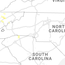
North Carolina
| Local Time | Report Details |
|---|---|
| 5:10 PM EDT | Trees and powerlines down blocking entire roadwa in iredell county NC, 41.2 miles NNW of Charlotte, NC |
| 7:15 PM EDT | 911 call center reports numerous trees down across buncombe county... including arde in buncombe county NC, 43.6 miles N of Greenville, SC |
| 7:35 PM EDT | 911 call center reports a tree down and shingles blown off roof of a hous in henderson county NC, 36.7 miles NNE of Greenville, SC |
Kansas
| Local Time | Report Details |
|---|---|
| 3:13 PM MDT | Ping Pong Ball sized hail reported near Goodland, KS, 45.1 miles W of Colby, KS, ping pong size hail reported 10 miles north of ruleton at 3:13 pm mdt (time estimated via radar). |
| 3:18 PM MDT | Hen Egg sized hail reported near Goodland, KS, 45.3 miles W of Colby, KS, social media report of hail ranging from pea to around to bigger than golf ball size hail. hail lasted around 20 minutes. |
| 3:20 PM MDT | Half Dollar sized hail reported near Goodland, KS, 45.3 miles W of Colby, KS, public report via social media with photo of 1-1.25 inch hail. time estimated. |
| 3:35 PM MDT | Quarter sized hail reported near Goodland, KS, 35.9 miles W of Colby, KS, nws employee reported penny to quarter size hail covering the ground at the intersection of hwy 27 and county road 73 at 3:35 pm mdt (time estimated via radar). |
| 3:35 PM MDT | Ping Pong Ball sized hail reported near Goodland, KS, 38.7 miles W of Colby, KS, retired nws employee reports 1-1.5 inch hail... some light accumulation. prior to hail... blowing dust with 1/4 mile visibility occurred. |
| 5:29 PM CDT | Storm damage reported in rawlins county KS, 30.6 miles N of Colby, KS |
| 5:59 PM CDT | Storm damage reported in sheridan county KS, 25.9 miles ENE of Colby, KS |
| 6:03 PM CDT | Hen Egg sized hail reported near Dresden, KS, 31.1 miles ENE of Colby, KS, report via social media of 2 inch hail. |
| 6:27 PM CDT | Public report via social media of 65 mph winds and blowing dust reducing visibility to a quarter mile at time in sheridan county KS, 32.5 miles E of Colby, KS |
| 6:35 PM CDT | Public report via social media with photo/video of accumulating pea to nickel size hail... winds 60+ mph... and blowing dust with visibility about 30 feet at times... t in graham county KS, 50.7 miles E of Colby, KS |
| 7:16 PM CDT | Quarter sized hail reported near Haddam, KS, 62.8 miles NW of Manhattan, KS, a few nickel to quarter sized hailstones. |
| 7:26 PM CDT | Ambient weather statio in rooks county KS, 40.2 miles N of Hays, KS |
| 7:32 PM CDT | Davis weatherlin in phillips county KS, 48.3 miles N of Hays, KS |
| 7:32 PM CDT | Davis watherlin in rooks county KS, 38.7 miles N of Hays, KS |
| 7:36 PM CDT | Ping Pong Ball sized hail reported near Morrowville, KS, 56 miles NW of Manhattan, KS |
| 7:39 PM CDT | Storm damage reported in rooks county KS, 44 miles NNE of Hays, KS |
| 7:39 PM CDT | Quarter sized hail reported near Clyde, KS, 53.1 miles WNW of Manhattan, KS, pea to quarter size hail. |
| 7:56 PM CDT | Golf Ball sized hail reported near Alton, KS, 46.1 miles NNE of Hays, KS, law enforcement reports golf ball size hail in alton. |
| 8:03 PM CDT | Quarter sized hail reported near Linn, KS, 46.7 miles NW of Manhattan, KS |
| 8:05 PM CDT | Davis weatherlink statio in osborne county KS, 50.6 miles NE of Hays, KS |
| 8:15 PM CDT | Quarter sized hail reported near Hanover, KS, 58.3 miles NNW of Manhattan, KS |
| 8:15 PM CDT | Storm damage reported in smith county KS, 67.9 miles NNE of Hays, KS |
| 8:22 PM CDT | Quarter sized hail reported near Greenleaf, KS, 44.7 miles NNW of Manhattan, KS, spotter network report. |
| 8:23 PM CDT | Ping Pong Ball sized hail reported near Greenleaf, KS, 44.4 miles NNW of Manhattan, KS, quarter to ping pong ball size hail. |
| 8:26 PM CDT | Half Dollar sized hail reported near Bremen, KS, 51.7 miles NNW of Manhattan, KS, slightly larger than quarter size. |
| 8:37 PM CDT | Storm damage reported in jewell county KS, 84.1 miles NE of Hays, KS |
| 8:44 PM CDT | Storm damage reported in mitchell county KS, 77.6 miles ENE of Hays, KS |
| 8:45 PM CDT | Corrects time of previous tstm wnd dmg report from beloit. report from mping: 1-inch tree limbs broken; shingles blown of in mitchell county KS, 77.2 miles ENE of Hays, KS |
| 8:55 PM CDT | Half Dollar sized hail reported near Marysville, KS, 45.8 miles N of Manhattan, KS |
| 8:56 PM CDT | Hen Egg sized hail reported near Marysville, KS, 45.8 miles N of Manhattan, KS, report via spotter network. |
| 9:09 PM CDT | Kcnk asos measuremen in cloud county KS, 63.7 miles WNW of Manhattan, KS |
| 9:29 PM CDT | Kcnk asos measuremen in cloud county KS, 63.7 miles WNW of Manhattan, KS |
| 9:29 PM CDT | Half Dollar sized hail reported near Bremen, KS, 51.7 miles NNW of Manhattan, KS |
| 9:30 PM CDT | Personal weather statio in cloud county KS, 64.7 miles WNW of Manhattan, KS |
| 9:44 PM CDT | Personal weather statio in republic county KS, 72.9 miles SSE of Grand Island, NE |
| 10:10 PM CDT | Personal weather statio in nemaha county KS, 55.8 miles NNE of Manhattan, KS |
| 10:19 PM CDT | Report from mping: 1-inch tree limbs broken; shingles blown of in mitchell county KS, 77.2 miles ENE of Hays, KS |
| 10:50 PM CDT | Quarter sized hail reported near Saint George, KS, 7.7 miles E of Manhattan, KS, delayed report. |
Missouri
| Local Time | Report Details |
|---|---|
| 4:20 PM CDT | Quarter sized hail reported near Wyatt, MO, 32.5 miles SSE of Cape Girardeau, MO |
| 4:20 PM CDT | Golf Ball sized hail reported near Wyatt, MO, 32.5 miles SSE of Cape Girardeau, MO, golf ball sized hail. |
| 9:24 PM CDT | Estimated 60 mph winds with heavy rain and frequent lightnin in atchison county MO, 63.6 miles SSE of Omaha, NE |
Wyoming
| Local Time | Report Details |
|---|---|
| 3:59 PM MDT | Storm damage reported in campbell county WY, 50.6 miles NNE of Gillette, WY |
| 4:44 PM MDT | Golf Ball sized hail reported near Aladdin, WY, 65.2 miles ENE of Gillette, WY, mostly smaller with a few golf ball sized pieces. |
Mississippi
| Local Time | Report Details |
|---|---|
| 5:07 PM CDT | Tree fell down on home. no reported injurie in warren county MS, 39.9 miles WNW of Jackson, MS |
| 5:09 PM CDT | Tree fallen on home. no injuries reporte in warren county MS, 39.5 miles W of Jackson, MS |
| 6:39 PM CDT | Tree reported down on e gallman r in copiah county MS, 28 miles SSW of Jackson, MS |
| 6:50 PM CDT | Powerlines reported down. reported by social medi in madison county MS, 8 miles NNE of Jackson, MS |
| 6:53 PM CDT | Tree reported down via law enforcemen in madison county MS, 12.9 miles NNE of Jackson, MS |
South Dakota
| Local Time | Report Details |
|---|---|
| 4:46 PM MDT | Ping Pong Ball sized hail reported near Rapid City, SD, 5.3 miles NE of Rapid City, SD |
| 4:48 PM MDT | Ping Pong Ball sized hail reported near Rapid City, SD, 6.6 miles NE of Rapid City, SD, pictures show at least ping pong ball sized hail. time estimated from radar. |
| 4:52 PM MDT | Golf Ball sized hail reported near Rapid City, SD, 6 miles NE of Rapid City, SD, delayed report. time estimated from radar. |
| 5:00 PM MDT | Half Dollar sized hail reported near Box Elder, SD, 9.7 miles ENE of Rapid City, SD |
| 5:02 PM MDT | Quarter sized hail reported near Box Elder, SD, 9.7 miles ENE of Rapid City, SD |
| 5:03 PM MDT | Quarter sized hail reported near Box Elder, SD, 10.1 miles ENE of Rapid City, SD |
| 5:42 PM MDT | Ping Pong Ball sized hail reported near New Underwood, SD, 20.4 miles ENE of Rapid City, SD, time estimated from radar. |
| 5:45 PM MDT | Golf Ball sized hail reported near New Underwood, SD, 21.3 miles ENE of Rapid City, SD, lasted around 15 minutes (began at 530 pm) |
| 6:05 PM MDT | Quarter sized hail reported near Belle Fourche, SD, 50.9 miles NW of Rapid City, SD, image shows several hailstones near the size of quarters. time estimated from radar. |
| 6:10 PM MDT | Quarter sized hail reported near Belle Fourche, SD, 51.5 miles NW of Rapid City, SD, time estimated from radar. |
| 6:35 PM MDT | Quarter sized hail reported near Nisland, SD, 50.4 miles NNW of Rapid City, SD, time estimated from radar. |
| 6:44 PM MDT | Quarter sized hail reported near Nisland, SD, 43.6 miles NNW of Rapid City, SD |
| 6:55 PM MDT | Golf Ball sized hail reported near Wall, SD, 52.4 miles E of Rapid City, SD, time estimated from radar. |
| 6:59 PM MDT | Storm damage reported in harding county SD, 106 miles N of Rapid City, SD |
South Carolina
| Local Time | Report Details |
|---|---|
| 8:00 PM EDT | 911 call center reports numerous trees down in landru in spartanburg county SC, 33 miles NE of Greenville, SC |
| 8:10 PM EDT | 911 call center reports numerous trees down in campobell in spartanburg county SC, 32.4 miles NE of Greenville, SC |
| 8:35 PM EDT | 911 call center reports numerous trees down in inma in spartanburg county SC, 32.7 miles ENE of Greenville, SC |
Connect with Interactive Hail Maps